Navigation
Install the app
How to install the app on iOS
Follow along with the video below to see how to install our site as a web app on your home screen.
Note: This feature may not be available in some browsers.
More options
Style variation
You are using an out of date browser. It may not display this or other websites correctly.
You should upgrade or use an alternative browser.
You should upgrade or use an alternative browser.
Guess the spot: Utah Edition
- Thread starter Ben
- Start date
Ship Mountain Point
That's the one. You are up.

- Joined
- Aug 18, 2018
- Messages
- 1,826
Looks like something you might find up Factory Butte way?
Nice photo!
Thanks, I will tell Rick! Not up the Factory Butte way.... but your guess is "warm".
It was a photography stop, not far from a popular backpacking route with more colorful formations.
John Morrow
Member
- Joined
- May 22, 2015
- Messages
- 1,144
Thanks, I will tell Rick! Not up the Factory Butte way.... but your guess is "warm".
It was a photography stop, not far from a popular backpacking route with more colorful formations.
Same rock formation as Factory perhaps? What is Factory exactly: Morrison, Dakota, or Mancos sandstones...
- Joined
- May 31, 2015
- Messages
- 3,354
I've been going through this list trying to think of anything that fits. Not helping a lot. Haha.
 www.blm.gov
So I'll throw out a guess. Mancos Mesa WSA.
National Conservation Lands: Utah: Wilderness Study Areas | Bureau of Land Management
BLM Utah administers 78 Wilderness Study Areas encompassing millions of acres. From 12,000 foot peaks to deep slot canyons, Wilderness Study Areas provide the intrepid hiker or backcountry horseman with views of unique rock formations, opportunity to glimpse sensitive species and walk in the...
So I'll throw out a guess. Mancos Mesa WSA.
- Joined
- Aug 18, 2018
- Messages
- 1,826
Same rock formation as Factory perhaps? What is Factory exactly: Morrison, Dakota, or Mancos sandstones...
@Jackson - not Mancos Mesa WSA.
@John Morrow - if I turn on the "Bedrock" feature in the Gaia App, then it shows it's the same color/bedrock as in the Factory Butte area. I do not know exactly what the bedrock is called. Another hint: If you turn around and walk west the Bedrock is dramatically different, many different colors in Gaia (and very scenic to watch in person and that area is much more familiar to most).
UtahBrian
God bless America. Let's save some of it.
- Joined
- Feb 15, 2018
- Messages
- 54
Mount Ellen-Blue Hills WSA? South Cainesville Mesa?
- Joined
- Aug 18, 2018
- Messages
- 1,826
Mount Ellen-Blue Hills WSA? South Cainesville Mesa?
no..... but the first guess is getting hot!
UtahBrian
God bless America. Let's save some of it.
- Joined
- Feb 15, 2018
- Messages
- 54
no..... but the first guess is getting hot!
Well, if it's hot I guess I'll throw in the Mt. Pennel WSA, being the second major peak in the Henrys, before letting someone else have a turn to guess.
John Morrow
Member
- Joined
- May 22, 2015
- Messages
- 1,144
So the colorful backpack must be Muley Twist?
- Joined
- Aug 18, 2018
- Messages
- 1,826
That’s it @UtahBrian - you are up!
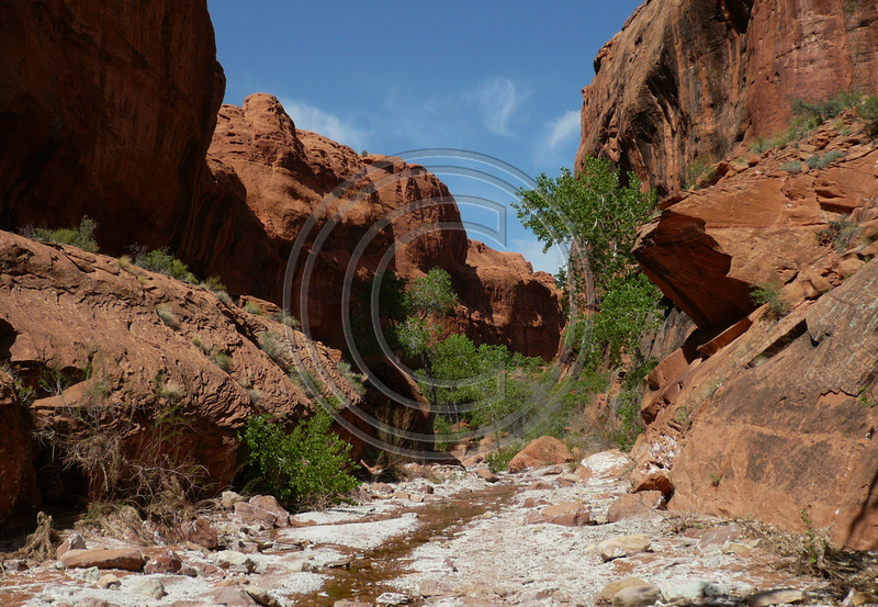
Here is the photo with coordinates, it's shot in a SE direction right off a pull out on Burr trail rd, (kind of in between Halls Creek Overlook south of the pull out and the switchbacks north of the pull out). The gps coordinates of the rock formation in the photo is attached below.
The border of the Mount Pennel Wilderness Study Area runs right up against Burr trail rd at that particular pull out, according to Gaia.
Here is more info about the Henry Mountains Wilderness units http://action.suwa.org/site/PageServer?pagename=WATE_henrymtns#u3
@John Morrow - I was thinking Halls Creek Narrows, doesn't it start at the overlook with views over the Waterpocket Fold?
Lower Muley Twist loop would also fit (though I'm guessing you or @fossana might handle the Lower Muley Twist loop as a long day hike") )
)

Here is the photo with coordinates, it's shot in a SE direction right off a pull out on Burr trail rd, (kind of in between Halls Creek Overlook south of the pull out and the switchbacks north of the pull out). The gps coordinates of the rock formation in the photo is attached below.
The border of the Mount Pennel Wilderness Study Area runs right up against Burr trail rd at that particular pull out, according to Gaia.
Here is more info about the Henry Mountains Wilderness units http://action.suwa.org/site/PageServer?pagename=WATE_henrymtns#u3
@John Morrow - I was thinking Halls Creek Narrows, doesn't it start at the overlook with views over the Waterpocket Fold?
Lower Muley Twist loop would also fit (though I'm guessing you or @fossana might handle the Lower Muley Twist loop as a long day hike
)Attachments
UtahBrian
God bless America. Let's save some of it.
- Joined
- Feb 15, 2018
- Messages
- 54
Looking down at those mesas at the base of the Henrys was the view of the happiest moment of my life.
I'd brought my five year old on a backpacking trip in the Waterpocket Fold. It was a winter trip and the fresh water spring near our camp froze solid overnight but we warmed up as we hiked up over the Fold on the Post cutoff. There was ice over part of the trail and I passed it with a little climbing, including a section of stemming with left and right foot on opposite walls. My daughter wanted to learn how to do it, so I taught her to put her little feet on one side and her hands on the other and walk her way up horizontally.
Then on top we looked out over the Henrys mesas in full warm sun. I got out the organic peanut butter and Braeburn apples and wheat crackers. There was an eight foot high block boulder with vertical sides behind my sunny view spot on the ridge and she would scale the back side of it repeatedly and then fling herself giggling off the edge into my waiting hands below. We'd share a peanut butter apple slice and a cracker and she'd climb up again.
When we got back to camp I discovered that she had overstuffed her tiny little pack with an explosion of stuffed animals and that she'd transferred all the sweet snacks for the whole trip into her bag while I wasn't looking.
--
Okay, friends. It's winter around here, so tell me where this one is.
Last edited:
UtahBrian
God bless America. Let's save some of it.
- Joined
- Feb 15, 2018
- Messages
- 54
Is it Farmington Canyon?
Good guess, but not Farmington Canyon.
- Joined
- May 31, 2015
- Messages
- 3,354
Thanks. Interesting to see what looks like an unplowed, narrow canyon road with a bridge, a speed limit sign, and no sled tracks. I'll have to rack my brains.Good guess, but not Farmington Canyon.
UtahBrian
God bless America. Let's save some of it.
- Joined
- Feb 15, 2018
- Messages
- 54
Could that be a bridge and such over City Creek near downtown Salt Lake City. Have been up there a time or two.
Yes it is, Kmy. It’s seven miles upcanyon from downtown, 200 yards from the end of the road. Inside the municipal borders of SLC. (There are not a lot of Salt Lake City street scenes in this thread.)
You’re up.