Guess the spot: Utah Edition

Found it - going up into Indian Canyon, been right by there a number of times. Very cool country. Here are my two screenshots:

View attachment 57460 View attachment 57461
That's it! The rock art seems like it's in an unusual location. Makes me wonder if there are some pit houses nearby. There's more rock art (Ute petroglyphs) in a nearby canyon that I haven't been to yet.
 
Really? Are you sure? :)

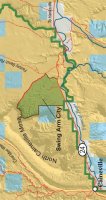
OK, here's one - some of you may love this place while others hate it. Me, I think it's an entertaining place to camp when just passing through - and my tire-biter dogs love it (big hint). Name the actual place, not just the area.

View attachment 57436

Beautiful. Are we near Hanksvill?
Really? Are you sure? :)

OK, here's one - some of you may love this place while others hate it. Me, I think it's an entertaining place to camp when just passing through - and my tire-biter dogs love it (big hint). Name the actual place, not just the area.

View attachment 57436

Why swingarm city and who is Ben?
 
As for Ben, I have no idea who he really is...but he says he loves this site, and I do, too. :)

And the above photo is not near Hanksville, but I know you've been there or close. In fact, you were just in the vicinity on your way back from your latest camping trip.

I have no idea where the name Swing Arm City came from, but I suspect it's a dirt bike term, as bikes have swing arms.

swing-arm-lrg-map.jpg
 
Last edited:
Very cool!

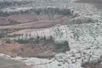
Where is this?

View attachment 57462

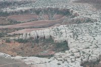
Don't know but it sure is beautiful. Taken from a plane? Reminds me of the rocks just as you enter the two main camps in the Doll House.
As for Ben, I have no idea who he really is...but he says he loves this site, and I do, too. :)

And the above photo is not near Hanksville, but I know you've been there or close. In fact, you were just in the vicinity on your way back from your latest camping trip.

I have no idea where the name Swing Arm City came from, but I suspect it's a dirt bike term, as bikes have swing arms.

View attachment 57463

Okay. I've been all over that area. Big trip coming up in late September with Ross from England. My last trip was to the Wedge for two nights, Warner Lake for four nights, then the Wedge for one night on the way home. I seek lightning and Warner Lake did not disappoint. Are you familiar with Buckeye on the east side of the LaSals? Is it worth the drive other than I don't have to hide my pipe?
 
  • Like
Reactions: Ben
Yes, taken from a plane. In fact, the airport is very close. You know where it is, even if you don't know you know. :) You've been within about 10 miles or less of it. Not anywhere close to the Maze.

LOL on hiding the pipe - better hide it till you get there. I've been to Buckeye, but it's not really a destination in my book, given that the San Juans aren't too much further east, but it's pretty in its own way.

Might add that the scrub oak in this part of Colorado is already turning, so Buckeye might be turned by then also. Aspen colors should be prime for the higher mtns by then, though.
 
Last edited:
Yes, taken from a plane. In fact, the airport is very close. You know where it is, even if you don't know you know. :) Not anywhere close to the Maze.

LOL on hiding the pipe - better hide it till you get there. I've been to Buckeye, but it's not really a destination in my book, give that the San Juans aren't too much further east, but it's pretty in its own way.

Okay. Did they have the cool stove stands when you were at Warner?
 
I edited my message above to say you've been within 10 miles of it, maybe closer. I don't recall any stove stands, but I always cook on my one-burner Coleman on the tailgate, so I don't pay attention to such things. Actually, I usually don't cook at all, but eat gorp and little white donuts and stuff like that. :)

As for teasing you, what day did you return from Warner? That was the day you were so close to it, in fact, you probably even gazed over at it. :D Oh, and also the day you went to Warner, unless you drove the River Road, then you weren't close at all.
 
Last edited:
I edited my message above to say you've been within 10 miles of it, maybe closer. I don't recall any stove stands, but I always cook on my one-burner Coleman on the tailgate, so I don't pay attention to such things. Actually, I usually don't cook at all, but eat gorp and little white donuts and stuff like that. :)

As for teasing you, what day did you return from Warner? That was the day you were so close to it, in fact, you probably even gazed over at it. :D Oh, and also the day you went to Warner, unless you drove the River Road, then you weren't close at all.

It's a 4' pipe with a platform for the stove. I must heat water in the morning. It's coffee or violence. The choice is yours. Okay, coffee or pouting but I am a master pouter. I can pout you to violence.

I went up from Spanish Valley. I'm sure I went through that layer. Maybe Spanish Valley overlook.
 
No, not Spanish V. or close. You're above that layer. Go north, young man, go north.

I, too, am a coffee-based life form. I do have to admit I use my stove in the mornings for hot water. I fire up my stove w/o even getting out of my bag.

That's the same layer (Moab Tongue) that makes up the Biscuits over in Arches, but this isn't in Arches. The Moab Tongue used to be considered the uppermost member of the Entrada Fm but is now considered the lowest layer of the Carmel Fm. IIRC.
 
Last edited:
No, not Spanish V. or close. You're above that layer. Go north, young man, go north.

I, too, am a coffee-based life form. I do have to admit I use my stove in the mornings for hot water. I fire up my stove w/o even getting out of my bag.

That's the same layer (Moab Tongue) that makes up the Biscuits over in Arches, but this isn't in Arches. The Moab Tongue used to be considered the uppermost member of the Entrada Fm but is now considered the lowest layer of the Carmel Fm. IIRC.

Okay, I'm confused.

Will you marry me? I'm a slob but I have lots of campfire stories. ;)
 
Sure. I'm a sucker for campfire stories. Meet me at the above spot. :smilecoffee:

Let's see...airport, white biscuit rocks, you can see it as you pass by, not Arches, north of town...
 
Last edited:
OK, since that one doesn't seem to be getting any guesses, it's the view of Tusher Canyon as you're taking off from the Moab airport.

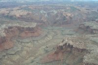
Here's a new one - kind of hazy but should be easier:

wherever.JPG
 
Similar threads
Thread starter Title Forum Replies Date
C Guess the Spot: somewhere in Southern Utah General Discussion 4
Outdoor_Fool The value of the various Guess the Spot threads General Discussion 6
wsp_scott NYTimes article: Guess the spot saves someone's life General Discussion 1
JDWalters Guess the Spot: Eastern US Edition General Discussion 515
LarryBoy Guess the Spot: Trip Reports Edition Hiking & Camping 5
balzaccom Guess the Spot--DIY version General Discussion 33
Artemus Guess the Spot: International Edition General Discussion 283
Jammer Guess the Spot (not where you think) General Discussion 10
Backcountry Post Guess the spot: Maps Edition General Discussion 4670
Backcountry Post Guess the spot General Discussion 7683
Perry Can You Guess Where The Uintas Are? General Discussion 5
J Identify the spot Utah: I don't know where it is General Discussion 2
Happyidiot Looking for camping spot close to Denver. General Discussion 2
Jammer Havasu Falls Extra Spot General Discussion 3
Nick Spot X Gear 27
SKLund Sticking with SPOT Gear 0
Ross Unofficial Where’s The Spot General Discussion 0
Perry Good Deal on a Spot Gen 3 Gear 5
Jammer Spot/InReach for May? Trip Planning 7
Bridgette Good camping spot in the Uintas with 4WD Trip Planning 0
jonmessina Spot Tracker Rental? Trip Planning 1
uintahiker The bloodiest spot in Arizona Hiking & Camping 0
Jammer InReach vs Spot Messenger 2013 Gear 32
wnorton Do you use Spot Connect or DeLorme InReach? Gear 6
Nurrgle Good car camping spot in the Uintas General Discussion 9
Nick SPOT Connect Gear 2
SteveR SE Utah Bugs in May? General Discussion 5
B Southern Utah March suggestions? Trip Planning 5
desertvic Howdy from rural Utah Noobs: Introduce yourself! 1
Ugly Floating Island- Utah Trip Planning 8
Normie Invite Looking for shuttle partner -- two trips in Southern Utah Meet Up (Members Only) 5
BeardoMcGrath Oh look yet another Utah conditions thread: mid May 2023 Trip Planning 9
Vegan.Hiker 8 day trip to Utah Trip Planning 10
ww.joedirt.do Hello from Utah! Noobs: Introduce yourself! 0
Martyn Hi from Hurricane Utah! Noobs: Introduce yourself! 1
B Good trips in Southern Utah given current conditions Trip Planning 26
saltybird SE Utah NPs in April Trip Planning 13
C Grand Gulch Cedar Mesa Utah 11 Day Backpack October 2022 Backpacking 10
T Amazing Discovery in Utah-Glen Canyon Trip Planning 65
V four day backpacking trip in southern Utah starting this weekend Trip Planning 4
regehr recent Utah meteorite General Discussion 0
TrailScot "I Would Walk 500 Miles ..." - A Utah Adventure - April 2022 - Final Part Backpacking 11
TrailScot "I Would Walk 500 Miles ..." - A Utah Adventure - April 2022 - Part 5 Backpacking 3
TrailScot "I Would Walk 500 Miles ..." - A Utah Adventure - April 2022 - Part 4 Backpacking 10
TrailScot "I Would Walk 500 Miles ..." - A Utah Adventure - April 2022 - Part 3 Backpacking 4
TrailScot "I Would Walk 500 Miles ..." - A Utah Adventure - April 2022 - Part 2 Backpacking 5
TrailScot "I Would Walk 500 Miles ..." - A Utah Adventure - April 2022 - Part 1 Backpacking 6
Rudolf_The_Red Hello from BFE, Utah! Noobs: Introduce yourself! 4
H location of thirteen faces-horse canyon Utah Hiking & Camping 4
TrailScot Dripping Canyon to Grand Gulch, Cedar Mesa, Utah - March 2022 Hiking & Camping 7

Similar threads

Back
Top