Grand Canyon Loop: Thunder River -> Tapeats -> Kanab -> Sowats

stretch

Member
Joined
Dec 16, 2020
Messages
18
This summer I had the opportunity to spend 6 weeks traveling around the American west with my Danish partner and to take her on her first backpacking trip. We decided on the Grand Canyon, as it was too early in the season to be in the mountains (May), and neither of us had ever been in the big ditch before.

Quite by chance, we arrived to the North Rim the night before opening day. Driving in early the next morning, there was a long line of bumper to bumper traffic to get in. Still, we were only third in line at the permit office and within 30 minutes we walked out with our permits for the exact itinerary we wanted. Only having one car, we decided to do a loop - leaving from Indian Hollow Campground on the north rim, down tapeats creek, then along the colorado river to kanab canyon, up to Sowatt's point, then cross country back to the car.

The Grand Canyon is truly a rugged, wild place, with scenery unlike anything I've ever encountered before.
2021-05-16_07-15-57_336.jpeg
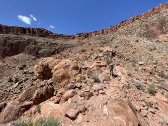
After a five minute walk from the trailhead, we emerged on the rim.

2021-05-16_14-22-01_853.jpg
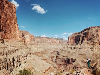
From the rim, we descended roughly 5k feet down some very steep, loose, and rocky paths. It must have been a brutally difficult task to build these trails, but I'm so thankful for the folks that did it. Hats off to the CCC.

2021-05-16_17-37-40_657.jpeg
See that patch of green below and to the left? That's Thunder Spring, a fast flowing stream of water that comes gushing right out of the canyon wall.

2021-05-16_16-19-43_375.jpeg
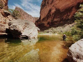
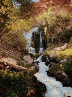
Thunder Spring (out of which flows Thunder River) up close. After walking for miles through hot, dry, exposed desert, we entered this oasis of fresh cool air, cottonwoods, flowers, and birdsong.
2021-05-16_16-45-01_847.jpeg2021-05-17_08-01-02_049.jpg
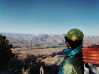
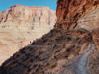
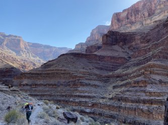
The topography and sheer size of the canyon walls allow one to share a bit of the sense of scale that is usually completely lost with cell phone photos.

2021-05-17_09-53-20_032.jpeg
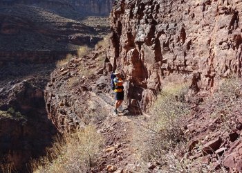
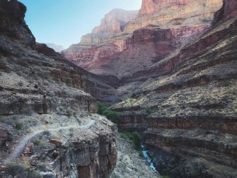
The Tapeats creek trail follows these ledges down to the inner reaches of the canyon. Not pictured here, but there are some moments that are unexpectedly precarious and sketchy for an official national park trail.
2021-05-17_08-40-03_696.jpeg
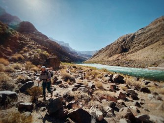
The colorado! That is some cold, cold water.

2021-05-17_10-09-36_531.jpg
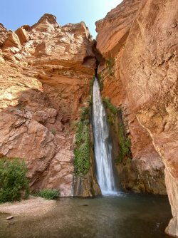
We followed a rough use trail along the river to Deer Creek falls, a popular place for rafting trips to stop. From here, we had to yogi a ride on a boat down to Kanab Canyon. You can walk it on game trails high above the river, but we thought it would be more fun to ride.
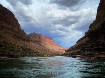

2021-05-17_14-04-59_190.jpeg
It was definitely more fun to ride. We hitched our way downstream with an awesome group of folks.

The next morning, we started up Kanab Creek.
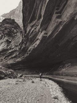
2021-05-18_10-31-03_000.jpeg2021-05-18_08-52-30_541.jpeg
2021-05-18_15-26-14_000.jpeg
2021-05-18_16-08-23_000.jpeg
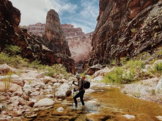
There is a bit of a social trail from time to time, but most of the time we were wading through the water, rock hopping, crawling through boulder nests, and traversing ledges above the canyon floor. It took a while, but it was thoroughly enjoyable.

2021-05-18_16-49-36_516.jpeg
Eventually we made it to the aptly named showerbath spring. One of many WOW! moments on the trip.

2021-05-19_08-14-06_911.jpeg
A mile or two beyond showerbath, the canyon dried out completely. It felt like walking on a highway after spending a full day in Kanab.
We followed a series of side canyons back up to the esplanade, none of which would I want to be anywhere near during a rain storm.

2021-05-19_11-14-28_669.jpg
This canyon has been a sacred place for a very long time.

2021-05-19_15-56-16_000.jpeg
Saying goodbye to the canyon after a long steep climb up from the esplanade to the rim.

A cautionary tale from the way up: I was walking along a steep section when I hopped with one foot onto a large rock in the trail. As I landed, it rolled outwards with my full weight on it, sending me over the side. Without thinking or doing anything consciously, my body shifted to stay upright, landing with one foot on a ledge a full body-length below the trail and reaching an arm out to grab a small incut rock edge with just the fingertips on one hand. There was a shocked silence between my partner and I, the only sounds were the stones skittering down the steep rock slab and over the cliff edge below. It happened in an instant, and it was a truly humbling and eye-opening moment - the closest I've come to serious consequences in thousands of miles of hiking, and it happened within a half-mile of the trailhead, when mentally the hike was already "over".

We hugged, took a couple deep breaths, and made our way to the rim where we enjoyed a beautiful sunset and dinner from Sowat's point. The next morning, we had an easy six mile hike cross country to the Indian Hollow Camp. All in all, it ended up being one of my favorite trips ever, and I can't wait to get back out and explore some other parts of the canyon.
 
Last edited:
Nice trip

Been top to bottom kanab creek, been down to deer creek and tapeats quite a few times... kanab is always spectacular. You can hike from kanab crk to deer creek along the river.....about 1 1/2 days.... Or if you are really tough take the cranberry route up thru the red wall to the esplanade....
 
do you mind commenting on how crowded it is? like how many groups did you see while hiking? is there competition for campsites?
 
Nice trip

Been top to bottom kanab creek, been down to deer creek and tapeats quite a few times... kanab is always spectacular. You can hike from kanab crk to deer creek along the river.....about 1 1/2 days.... Or if you are really tough take the cranberry route up thru the red wall to the esplanade....
I had heard from friends that the walk from Deer Creek to Kanab was the slowest part of the entire Hayduke trail. It looked rough from river level! I would like to go back and try the Cranberry route sometime. Very beautiful area, totally new to me. Do you have a favorite time of year to be out there?
 
do you mind commenting on how crowded it is? like how many groups did you see while hiking? is there competition for campsites?
We saw two backpacking groups in the 4.5 days we were out there (we shared a campsite with one of those groups our first night (tapeats) but there were enough separated tent sites that we didn't know they were there until they hiked by the next morning). I'd say we probably were a little bit lucky, the area around thunder river/tapeats/deer creek probably sees a fair amount of people due to the beauty and relatively easy access.
 
We saw two backpacking groups in the 4.5 days we were out there (we shared a campsite with one of those groups our first night (tapeats) but there were enough separated tent sites that we didn't know they were there until they hiked by the next morning). I'd say we probably were a little bit lucky, the area around thunder river/tapeats/deer creek probably sees a fair amount of people due to the beauty and relatively easy access.
thanks!!
did some of the Teton Crest Trail this summer and it was crowded and I'm looking to avoid repeating that. this sounds just fine.
 
do you mind commenting on how crowded it is? like how many groups did you see while hiking? is there competition for campsites?
I did the Deer Creek/Tapeats loop in Oct. 4 years ago. The only time it felt a little crowded is when I passed a group of rafters who were headed up to the DC narrows. One of them gave me a beer so it worked out OK. There are no day hikers coming down from the top so that keeps traffic to a minimum. I spent 2 full days on the trail and I don't think I saw more than 3 other parties each day. Camping is by permit only so there's really no competition. I only spent one night (Lower Tapeats) and there was only one other group there.
 
Great report. Glad you caught yourself there at the top. Also smart to save a day and ride on a raft. We got offered and I said no, but although I am glad I did the walk across to Kanab and gashed my shin on some granite, I would not say no next time.

Those springs along those routes are all awe-inspiring and I spent time just sitting and looking at them. Nice to revisit.
 
This summer I had the opportunity to spend 6 weeks traveling around the American west with my Danish partner and to take her on her first backpacking trip. We decided on the Grand Canyon, as it was too early in the season to be in the mountains (May), and neither of us had ever been in the big ditch before.

Quite by chance, we arrived to the North Rim the night before opening day. Driving in early the next morning, there was a long line of bumper to bumper traffic to get in. Still, we were only third in line at the permit office and within 30 minutes we walked out with our permits for the exact itinerary we wanted. Only having one car, we decided to do a loop - leaving from Indian Hollow Campground on the north rim, down tapeats creek, then along the colorado river to kanab canyon, up to Sowatt's point, then cross country back to the car.

The Grand Canyon is truly a rugged, wild place, with scenery unlike anything I've ever encountered before.

View attachment 101925
After a five minute walk from the trailhead, we emerged on the rim.


View attachment 101926
From the rim, we descended roughly 5k feet down some very steep, loose, and rocky paths. It must have been a brutally difficult task to build these trails, but I'm so thankful for the folks that did it. Hats off to the CCC.


View attachment 101932
See that patch of green below and to the left? That's Thunder Spring, a fast flowing stream of water that comes gushing right out of the canyon wall.


View attachment 101928
Thunder Spring (out of which flows Thunder River) up close. After walking for miles through hot, dry, exposed desert, we entered this oasis of fresh cool air, cottonwoods, flowers, and birdsong.

View attachment 101929View attachment 101933
The topography and sheer size of the canyon walls allow one to share a bit of the sense of scale that is usually completely lost with cell phone photos.


View attachment 101935
The Tapeats creek trail follows these ledges down to the inner reaches of the canyon. Not pictured here, but there are some moments that are unexpectedly precarious and sketchy for an official national park trail.

View attachment 101936
The colorado! That is some cold, cold water.


View attachment 101938
We followed a rough use trail along the river to Deer Creek falls, a popular place for rafting trips to stop. From here, we had to yogi a ride on a boat down to Kanab Canyon. You can walk it on game trails high above the river, but we thought it would be more fun to ride.


View attachment 101939
It was definitely more fun to ride. We hitched our way downstream with an awesome group of folks.

The next morning, we started up Kanab Creek.
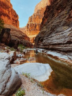
View attachment 101941View attachment 101940
View attachment 101942
View attachment 101943
There is a bit of a social trail from time to time, but most of the time we were wading through the water, rock hopping, crawling through boulder nests, and traversing ledges above the canyon floor. It took a while, but it was thoroughly enjoyable.
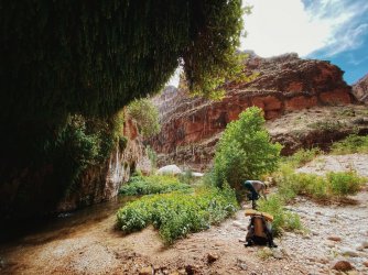
View attachment 101944
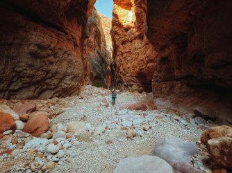
Eventually we made it to the aptly named showerbath spring. One of many WOW! moments on the trip.
View attachment 101945
A mile or two beyond showerbath, the canyon dried out completely. It felt like walking on a highway after spending a full day in Kanab.
We followed a series of side canyons back up to the esplanade, none of which would I want to be anywhere near during a rain storm.
View attachment 101946
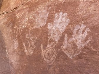
This canyon has been a sacred place for a very long time.
View attachment 101947
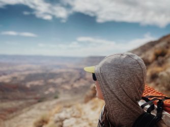
Saying goodbye to the canyon after a long steep climb up from the esplanade to the rim.

A cautionary tale from the way up: I was walking along a steep section when I hopped with one foot onto a large rock in the trail. As I landed, it rolled outwards with my full weight on it, sending me over the side. Without thinking or doing anything consciously, my body shifted to stay upright, landing with one foot on a ledge a full body-length below the trail and reaching an arm out to grab a small incut rock edge with just the fingertips on one hand. There was a shocked silence between my partner and I, the only sounds were the stones skittering down the steep rock slab and over the cliff edge below. It happened in an instant, and it was a truly humbling and eye-opening moment - the closest I've come to serious consequences in thousands of miles of hiking, and it happened within a half-mile of the trailhead, when mentally the hike was already "over".

We hugged, took a couple deep breaths, and made our way to the rim where we enjoyed a beautiful sunset and dinner from Sowat's point. The next morning, we had an easy six mile hike cross country to the Indian Hollow Camp. All in all, it ended up being one of my favorite trips ever, and I can't wait to get back out and explore some other parts of the canyon.
Nice report and pictures. Thanks!
 
A cautionary tale from the way up: I was walking along a steep section when I hopped with one foot onto a large rock in the trail. As I landed, it rolled outwards with my full weight on it, sending me over the side. Without thinking or doing anything consciously, my body shifted to stay upright, landing with one foot on a ledge a full body-length below the trail and reaching an arm out to grab a small incut rock edge with just the fingertips on one hand. There was a shocked silence between my partner and I, the only sounds were the stones skittering down the steep rock slab and over the cliff edge below. It happened in an instant, and it was a truly humbling and eye-opening moment - the closest I've come to serious consequences in thousands of miles of hiking, and it happened within a half-mile of the trailhead, when mentally the hike was already "over".
I had a similar experience in the same area back in October, but unfortunately I wasn't as lucky as you. My two sons and I were on day one of a 5 day trip in Kanab Creek. We spent the night at Sowats Point and early the next morning started down the trail. Somewhere around Mt. Sheep Spring I lost my footing (don't remember how and the boys didn't see it) and slid headfirst about 30' down a steep gully, bouncing my head off rocks the entire way. I was in rough shape and we ended up using my Garmin inreach to notify search and rescue.

After they arrived and assessed my condition I got airlifted out to the hospital in Flagstaff, where I spent 5 days with a fractured skull and a very bad concussion. It was the first time in my life to have serious consequences, and the fact that it happened without warning on a relatively benign section of trail has really opened my eyes and changed my point of view. Most of my previous trips have been solo, and I'm sadly aware that my days of doing that are likely over. Before the accident I was always optimistic and carefree, and I don't know if I'll ever have that outlook again.
 
.
 
Last edited:
I had a similar experience in the same area back in October, but unfortunately I wasn't as lucky as you. My two sons and I were on day one of a 5 day trip in Kanab Creek. We spent the night at Sowats Point and early the next morning started down the trail. Somewhere around Mt. Sheep Spring I lost my footing (don't remember how and the boys didn't see it) and slid headfirst about 30' down a steep gully, bouncing my head off rocks the entire way. I was in rough shape and we ended up using my Garmin inreach to notify search and rescue.

After they arrived and assessed my condition I got airlifted out to the hospital in Flagstaff, where I spent 5 days with a fractured skull and a very bad concussion. It was the first time in my life to have serious consequences, and the fact that it happened without warning on a relatively benign section of trail has really opened my eyes and changed my point of view. Most of my previous trips have been solo, and I'm sadly aware that my days of doing that are likely over. Before the accident I was always optimistic and carefree, and I don't know if I'll ever have that outlook again.
Very sobering - what an upsetting experience that must have been for all of you. Thank goodness for SAR.
 
Wonderful photos and report! We'd like to do another magical trip in GC (previous Hermit -> Granite Rapids -> Monument -> Indian Garden) but I'm not sure we could manage the sketchy parts on this one. Also, years ago I read about the family trip turned tragedy at Tapeats and have been intimidated by that area ever since. I'd love to hear more about the hard parts on your route so we can judge whether it's something we can consider... I realize the hardest part for you was the unexpected fall near the top (glad you got back up safe and sound!), but I'm thinking of the other, earlier part.
 
Wonderful photos and report! We'd like to do another magical trip in GC (previous Hermit -> Granite Rapids -> Monument -> Indian Garden) but I'm not sure we could manage the sketchy parts on this one. Also, years ago I read about the family trip turned tragedy at Tapeats and have been intimidated by that area ever since. I'd love to hear more about the hard parts on your route so we can judge whether it's something we can consider... I realize the hardest part for you was the unexpected fall near the top (glad you got back up safe and sound!), but I'm thinking of the other, earlier part.
There isn't anything that sketchy on the Thunder River Deer Creek loop. The Bill Hall portion is very steep, but you can use Indian Hollow instead (longer but not as steep). If flow is high on Tapeats you don't need to cross as there are trails on both sides of the creek. Not crossing means making several climbs/descents to get around cliffs and there is one spot with some exposure but it's not too bad as long as those things don't freak you out. The route from Tapeats to Deer Creek along the River has a lower option that has about 30' of serious exposure, but there is an option to climb higher and avoid that spot. Everything else is pretty straightforward. It's rougher than the corridor trails on the South Rim, but the trails are easy to follow. It's a great hike with some stunning scenery.DSC00080 (3).JPG

Sketchy trail along River...it's several hundred feet straight down to the water here!
 
There isn't anything that sketchy on the Thunder River Deer Creek loop. The Bill Hall portion is very steep, but you can use Indian Hollow instead (longer but not as steep). If flow is high on Tapeats you don't need to cross as there are trails on both sides of the creek. Not crossing means making several climbs/descents to get around cliffs and there is one spot with some exposure but it's not too bad as long as those things don't freak you out. The route from Tapeats to Deer Creek along the River has a lower option that has about 30' of serious exposure, but there is an option to climb higher and avoid that spot. Everything else is pretty straightforward. It's rougher than the corridor trails on the South Rim, but the trails are easy to follow. It's a great hike with some stunning scenery.View attachment 108296

Sketchy trail along River...it's several hundred feet straight down to the water here!
Thanks so much - this is really helpful. It sounds promising, and we'll add this to our list. :)
 
Last edited:
There isn't anything that sketchy on the Thunder River Deer Creek loop. The Bill Hall portion is very steep, but you can use Indian Hollow instead (longer but not as steep). If flow is high on Tapeats you don't need to cross as there are trails on both sides of the creek. Not crossing means making several climbs/descents to get around cliffs and there is one spot with some exposure but it's not too bad as long as those things don't freak you out. The route from Tapeats to Deer Creek along the River has a lower option that has about 30' of serious exposure, but there is an option to climb higher and avoid that spot. Everything else is pretty straightforward. It's rougher than the corridor trails on the South Rim, but the trails are easy to follow. It's a great hike with some stunning scenery.View attachment 108296

Sketchy trail along River...it's several hundred feet straight down to the water here!
Now that we've enjoyed our summer trip in the mountains, I'm thinking more about our October trip (Deer Creek -> Tapeats -> Thunder River going counter-clockwise). Am I correct that the spot in this photo is on the upper trail along the Colorado? If so, do you remember approximately where it's located? I looked on Google Earth but couldn't figure it out, and I think it would help me prep if I have a sense of where to expect this. Thanks in advance for your help.
 
Similar threads
Thread starter Title Forum Replies Date
TractorDoc Paintbrush Canyon / Cascade Canyon Loop -- Grand Teton NP September 11, 2023 Hiking & Camping 9
M Mee/Knowles Canyon Loop, Grand Junction Colorado Backpacking 4
Kerrie at Thru We Go Grand Canyon Backpack/Packraft Loop at New Hance Backpacking 11
fossana New Hance - Tonto - Grandview loop (Grand Canyon NP) Hiking & Camping 5
Bob Kanab Creek - Grand Canyon - Cranberry - Fishtail Mesa Loop Backpacking 17
Jammer Grand Canyon: Fishtail Mesa Loop Backpacking 35
Janice Such a GRAND Canyon - Deer Creek / Tapeats / Thunder River Backpacking 21
OldBill Short hike at the Grand Canyon of Pennsylvania Hiking & Camping 1
Bob The New Grand Canyon Trip Planning 1
F Grand Canyon hermits rest to granite rapids to bright angel Trip Planning 10
dennisrodman A week in the Grand Canyon / Boucher / Hermit / Tonto Trail Trip Planning 4
futurafree Grand Canyon norovirus General Discussion 6
TrailScot Dripping Canyon to Grand Gulch, Cedar Mesa, Utah - March 2022 Hiking & Camping 7
H Access to Grand Gulch via Water Canyon Trip Planning 2
M Grand Canyon NP, Royal Arch Route Backpacking 0
westy Grand Canyon-Parashant NM, Parashant canyon Hiking & Camping 4
marquis20 Day 1: Grand Teton Wilderness and Black Canyon of the Yellowstone - June 2021 Backpacking 0
westy Grand Canyon-Parashant Trip Planning 2
Rockskipper Application Period Open For 2023 Private River Trips Through Grand Canyon National Park General Discussion 0
TrailScot Step Canyon access to Grand Gulch, Cedar Mesa Trip Planning 17
balzaccom Grand Canyon of the Tuolumne Backpacking 2
kansas Good map of Grand Canyon-Parashant National Monument? Trip Planning 5
J Grand Canyon NP Backpack Pt. 2 Deer Cyn explore-->Esplanade-->Indian Hollow Tr. April 18-23, 2021 Backpacking 10
J Grand Canyon NP Backpack Pt. 1 Thunder River Tr.-->Esplanade-->Tapeats-->Deer. April 18-23, 2021 Backpacking 13
Nick Running the Grand Canyon in a Tule Raft General Discussion 2
D Grand Canyon Ideas Trip Planning 9
Bob Grand Canyon North Rim wildfire Trip Planning 4
gnwatts Grand Canyon by canoe On The Water 2
westy Cave Canyon, Grand Canyon west Hiking & Camping 5
montanaclimber advice Grand Canyon backpacking Spring 2020 Trip Planning 16
D New dams proposed for Little Colorado River/Grand Canyon General Discussion 2
Ross Permit places available for a Cape Solitude/Comanche Pt Grand Canyon backpack (+Canaan Mountain) Meet Up (Members Only) 0
fossana Deer Creek out-and-back (Grand Canyon NP) Hiking & Camping 5
G Grand Canyon hiking - need a ride Trip Planning 0
G Grand Canyon backpacking - need ride Backpacking 0
3 Grand Canyon Traverse - Map? Trip Planning 0
woodmaker_58 Grand canyon in February Trip Planning 4
woodmaker_58 grand canyon Trip Planning 2
stevecochranephotography Bright Angel Trail.. Grand Canyon, Arizona Hiking & Camping 1
N Grand Canyon and southern Utah in late November Trip Planning 3
Scott Chandler Finally Into the Grand Canyon Hiking & Camping 9
ramblinman New push for Uranium Mining near Grand Canyon General Discussion 3
cmgz Tuckup to Stairway -Grand Canyon Backpacking 5
A Escalante Route - Grand Canyon in late May 2017 Trip Planning 4
Wanderlust073 Grand Canyon in Winter - Hermit Trail to Bright Angel Backpacking 8
D Grand Canyon Escalade Project - ACT NOW General Discussion 12
Sandro Invite Grand Canyon, Utah Flats & Little Colorado, October Meet Up (Members Only) 7
b.stark A Grand Adventure-Grand Canyon 2016 Backpacking 7
Jon Carbaugh Grand Teton NP, Granite Canyon, Marion Lake Backpacking 12
IntrepidXJ Grand Gulch: Pollys Canyon to Collins Canyon Backpacking 1

Similar threads

Back
Top