Does knowing the geology of the CO Plateau give practical insight for trip planning?

RyanP

Member
Joined
Mar 1, 2015
Messages
578
Sometimes in guidebooks or in online trip reports, authors mention the specific type of sandstone/formation/layer of a particular area (e.g., "The next mile is on Kayenta ledges"). This has kind of bugged me for a long time because I have no idea what information they are trying to convey when they do this. By mentioning the Kayenta/Navajo/Wingate/Cedar Mesa/etc., are people just trying to show off their impressive knowledge of the geology, or are there practical implications contained in these statements? When you read that a certain area consists of a given type of sandstone/layer, does that give you information about practical matters such as water availability (waterpockets/potholes), sheerness of cliffs, etc? Frankly, I'm not personally very interested in learning about the geology for geology sake (maybe I should be), but I am very interested in learning practical skills that will help me better plan backpacking routes. Can you glean any practical info such as the following from a knowledge of the sandstone/formation type?
  • Easier to traverse from Point A to Point B on a map
  • Easier to find weak points to climb into or out of canyons (as opposed to sheer cliffs)
  • Better water availability
Sorry if the question is confusing. It just reflects my complete ignorance/confusion in this area---I get this vague feeling that I may be missing out on some important insights that I'm not even aware of. Thanks in advance for any input!
 
sure, it totally helps. I'm pretty crap at this stuff, so don't mind me. but even at my meager level of knowledge I know that:
  • a Navajo dome zone is likely to be convoluted and confusing
  • a Kayenta bench may well provide a nice way to walk for a ways
  • a Wingate wall is likely to stop you unless there's a really good breakdown or talus slope covering it up or something
people like @John Morrow are actually good at this stuff. I've never hiked with John but I've hiked with people who are probably at a similar level of knowledge and I've firsthand seen them do stuff like say that that area over there is where people would have sat and done some knapping on a cold sunny winter day, and then in fact when we get there there are plenty of chippings. or say that this side canyon probably goes and then it does. or we're about to hit a major dryfall and then we do. or people probably would have found a weakness in the cliffs over there and then it works out. of course this is much more than geology, it's overall desert sense, but it's totally real and geology is part of it
 
... It's a inner knowledge how landforms and features come together.... I couldn't tell you what layer of rock is what.. I do agree... Ruins, etc are located In certain rock layers. Slots form in certain layers.... So on...

 
I haven't spent a ton of time on the Colorado Plateau but still have definitely noted that different kinds of rock make different kinds of land forms. Surely people who spend the time to learn about the geology of the area have an advantage when it comes to navigating such a complex landscape.
 
I'm a geoarchaeologist and have done most of my work on the Colorado Plateau. I actually think a lot of what @regehr mentions comes from experience on the ground, as @Bob mentions. You don't need to know what different formations are called to be able to predict what you'll find there, but actually hiking and exploring will give you an innate sense. I've been out with geologists who can tell you everything you'd ever want to know about a formation academically yet aren't that savvy about where to actually hike. The ones who make good hiking companions have actually done fieldwork for years. Then you get people like @Outdoor_Fool who has worked in other fields outdoors and gained an incredible knowledge of what to expect, but from experience.

So my take is that if you're not all that interested in geology, don't worry about it. You won't be able to remember it all anyway. it's technical enough when you love it. Just go explore and you'll soon gain a sense of where to go. A lot of it is just common sense. For those who can remember all the technical details, yes, it's helpful, but only if you actually enjoy geology. My brother's great to hike with, as he's a geologist who has also done a lot of field work and loves the country. My cousin was an archaeologist in Alaska and didn't know much about geology yet was also a great hiking companion because he knew the country. And then there's @Kmatjhwy who probably knows the country of Yellowstone and the Tetons and environs better than anyone on Earth and I've never heard her mention any geology, so I suspect it's all from experience. But if you like geology, it's great to hike with someone who knows it. If it's not your interest, it can get pretty tedious.
 
Last edited:
speaking of academic experts, years ago I went on a trip with a professor in the U of Utah's atmospheric sciences department. it was sort of a stormy-looking day, clearly active weather, so of course we got rained on and of course he had not brought along a rain jacket :)
 
sure, it totally helps. I'm pretty crap at this stuff, so don't mind me. but even at my meager level of knowledge I know that:
  • a Navajo dome zone is likely to be convoluted and confusing
  • a Kayenta bench may well provide a nice way to walk for a ways
  • a Wingate wall is likely to stop you unless there's a really good breakdown or talus slope covering it up or something
That's about the extent of my knowledge of Utah geology, but even that helps in knowing what to expect in advance. In a similar vein- I often go hiking with a couple of wildflower experts, one of whom holds an actual degree in botany, and the other while not having any formal accreditation, is recognized locally as an authority. While I'm interested in a general sense about the flora, sometimes they lose me in the minutiae of identification- I'm happy just knowing that something is a member of the aster family, for instance.
 
That's about the extent of my knowledge of Utah geology, but even that helps in knowing what to expect in advance. In a similar vein- I often go hiking with a couple of wildflower experts, one of whom holds an actual degree in botany, and the other while not having any formal accreditation, is recognized locally as an authority. While I'm interested in a general sense about the flora, sometimes they lose me in the minutiae of identification- I'm happy just knowing that something is a member of the aster family, for instance.
yeah... my dad was a plant scientist so of course I know about three plants total, but I sure enjoy being out there with people who know all the species!
 
Now I want to go hiking with Bert from the Big Bang Theory...

I often think I should pay more attention to these things. I try reading past the second sentence explaining geological elements and fall asleep.
 
Fascinating thread - I can't keep any of this straight, and I don't have enough experience (YET) on the CO Plateau to anticipate these kinds of things. Hope for the future!
 
Very interesting question and thread. Both my husband and I are longtime geologists and hikers. In fact, I went into geology because I wanted to understand why mountains are where they are. It is an absolute ”yes” answer to all 3 of your questions. I think @rehegr described it well. I do agree that you can learn to understand the landscape if you are experienced enough.

I would add, that in addition to rock type, it is helpful to know where geologic faults and folds are. Springs and water sources are often along geologic faults and the only way out of a canyon is often in a fault zone (ie, the rocks are weakest and have either been folded or broken up in faults). Sometimes a geologic map will give you these clues beforehand.
 
Thanks all! Sounds like this kind of thing mostly just comes in the form of intuition gained from experience.
 
sure, it totally helps. I'm pretty crap at this stuff, so don't mind me. but even at my meager level of knowledge I know that:
  • a Navajo dome zone is likely to be convoluted and confusing
  • a Kayenta bench may well provide a nice way to walk for a ways
  • a Wingate wall is likely to stop you unless there's a really good breakdown or talus slope covering it up or something
people like @John Morrow are actually good at this stuff. I've never hiked with John but I've hiked with people who are probably at a similar level of knowledge and I've firsthand seen them do stuff like say that that area over there is where people would have sat and done some knapping on a cold sunny winter day, and then in fact when we get there there are plenty of chippings. or say that this side canyon probably goes and then it does. or we're about to hit a major dryfall and then we do. or people probably would have found a weakness in the cliffs over there and then it works out. of course this is much more than geology, it's overall desert sense, but it's totally real and geology is part of it
Thanks regehr; this is helpful. Do you usually take note of these things (Navajo dome zones, kayanta benches, wingate walls, etc) before a trip (when looking at the map and planning your route), or is it the kind of thing that is hard to plan in advance but useful once you're actually out there? And if it's the kind of thing you can figure out in the trip planning stage, what resources do you use for this?
 
Very interesting question and thread. Both my husband and I are longtime geologists and hikers. In fact, I went into geology because I wanted to understand why mountains are where they are. It is an absolute ”yes” answer to all 3 of your questions. I think @rehegr described it well. I do agree that you can learn to understand the landscape if you are experienced enough.

I would add, that in addition to rock type, it is helpful to know where geologic faults and folds are. Springs and water sources are often along geologic faults and the only way out of a canyon is often in a fault zone (ie, the rocks are weakest and have either been folded or broken up in faults). Sometimes a geologic map will give you these clues beforehand.
Thanks for the tip about the geologic faults. Is there a specific resource that you use to learn about these? The only tools I really use for trip planning are caltopo and google earth (other than guidebooks, online trip reports, weather forecasts, etc)... is there some similar readily-available online tool with geologic maps showing where the faults and folds are?
 
I love geology and am always happy to see certain rock formations. I know which formations I need to see if I wanna find fossils, petrified wood, and so on.
Southern Utah is so rich in certain rock layers and formations, it's just like opening a geological history book and walking back in time.

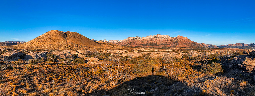
shadow%20selfie%20copy-XL.jpg


Just looking at this image makes me totally excited. It covered Triassic, Jurassic, and Quaternary rocks all at once.
The white rocks in the foreground are from the Shinarump Formation which formed in the Triassic. It formed during fast-flowing braided rivers. It amazes me to walk on it and imagine what it was like to be in the Triassic Time Period.
The Cinder Cone to the left is Quarternary volcanic rock, the youngest rock in the picture. In the back are the cliffs of Zion with the Kayenta Formation at the bottom. That's when dinosaurs roamed the area and all was covered by shallow seas and lakes. And then the Jurassic Navajo Sandstone, remnants of a massive erg that covered the area. It's so cool to think about it and what happened back then.

I always walk around and get super excited when I discover something interesting in the rocks. Kayenta for example is often crumbly and breaks easily. Navajo Sandstone with all its cross-bedding tells me in which direction the wind was blowing. It still blows me away that some of the sand comes from the ancient Appalachian Mountains which once were the height of the Himalayans before they eroded away and the rock crumbled to sand and was carried away.
Dang, I guess I just love geology too much, lol.
 
Thanks regehr; this is helpful. Do you usually take note of these things (Navajo dome zones, kayanta benches, wingate walls, etc) before a trip (when looking at the map and planning your route), or is it the kind of thing that is hard to plan in advance but useful once you're actually out there? And if it's the kind of thing you can figure out in the trip planning stage, what resources do you use for this?
I do almost all of my trip planning on google earth these days, and end up looking at the USGS maps much less often than I used to. I have a workflow that I don't like but that sort of works where I save a kml file out of GE and then convert to GPX and then load it into osmand on my phone, which frequently crashes due to the size of the GPX file, this software sucks. but on the other hand GAIA GPS just laughed when I tried to load in my GPX file, it's like 25x larger than that software supports -- not sure why all of this stuff has to be done so badly.

anyhow: in the imagery, the rock types (broadly speaking) are often pretty obvious, and yeah this informs route choices sometimes for sure. but mostly I think this info is useful on the ground. also sometimes guidebook authors refer to the kayenta bench or whatever and at that point it's pretty crucial to know what that refers to.

the whole game of sussing out from GE whether a route will go or not is pretty fun. of course I'm often wrong. I've traveled with people who have dramatically better desert sense than I do and it's really a thing to see. there are also geological maps of the rock types but I find those to mostly be sort of academically interesting, I've not really managed to figure out how to use those in trip planning.
Thanks! This is basically something I plan on gradually working on, little by little, over the rest of my life
 

Similar threads

Back
Top