Coyote Gulch to Halls Creek via Stevens Canyon

RyanP

Member
Joined
Mar 1, 2015
Messages
577
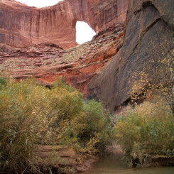
I would love to someday hike from Coyote Gulch to Halls Creek (or vice versa) via Steven's Canyon and the Baker route (no, not anytime soon during the pandemic; next Spring would likely be the earliest this happens). My main concern with this route is the level of exposure and scrambling. If anyone has done this route, could you please help me figure out if I would be in over my head or not?
  • I've done most of the trails in the Needles District and some of the ascents/descents in the Maze District, and felt comfortable doing them all with my heavy pack (maybe I handed the pack to my partner once or twice in the Maze, but I never used my rope to haul it).
  • I recently did the Beehive Traverse solo in Capitol Reef; one particular pour-off in that trip pushed me to about my limit---I was fine doing that trip, but would not want to do anything much harder from an exposure/scrambling perspective
  • I haven't done the Maze Overlook trail; from what I've read, I'm not sure if I'd be able to do it with a heavy pack or not.
  • I think I would be fine doing the Halls Creek "airport" shortcut route with a pack
  • I think I would be fine doing the Crack-in-the-Wall route with a pack.
  • I think I would NOT be fine doing the Jacob Hamblin Arch exit from Coyote Gulch (even without the pack).
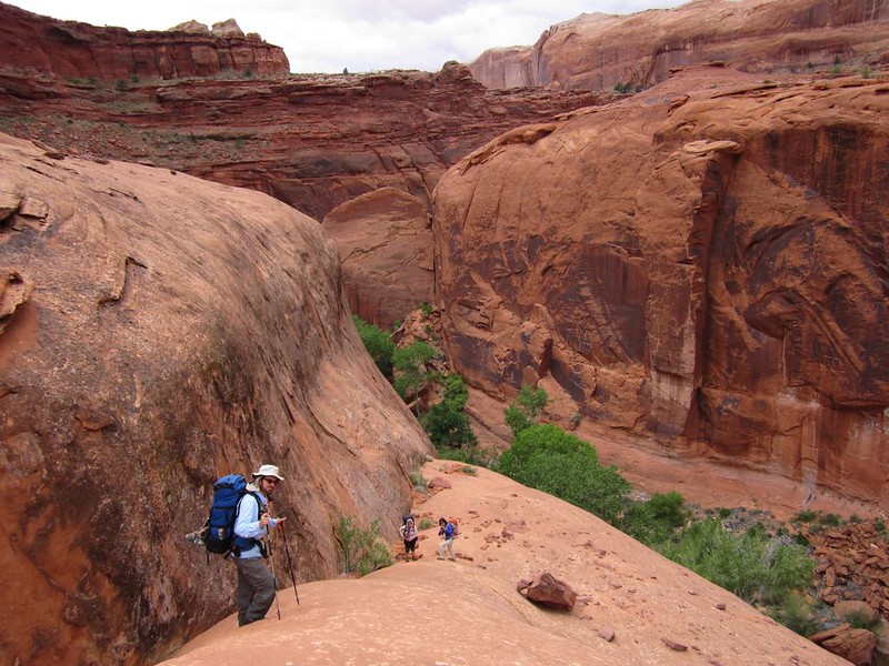
  • I'm not as scared of the route finding (I'll give myself plenty of time), the poison ivy (I'll just deal with it), or the water availability (I'll be picky with the timing of my trip). I've done a number of backpacking trips in Southern UT (Zion, Grand Gulch, Canyonlands, Escalante, etc) and more in the mountains... I just don't have tons of experience on steep slickrock.
From what I've read, the route has several challenging spots:
  • Getting down to the Escalante river from Coyote Gulch requires either traversing/descending a sketchy slope, finding a possible "rabbit hole" alternative right there that may or may not exist (has anyone taken that recently?), or taking a longer alternate route that drops down to the river a little further North (how hard is that alternate route?).
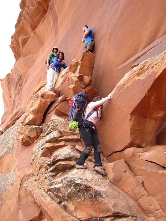
  • There is a "stack of rocks" climb that sounds pretty hard
  • There are a couple of Class 3-ish spots in Steven's Canyon; I've read varying reports on how hard they are. Some say that Allen overestimated the difficulty of Steven's Canyon.
Please let me know if this route is out of my league, or if you have any other comparisons of difficulty from an exposure/scrambling perspective. Also, if a particular direction is much easier or preferable, please let me know as well.

Thanks!
Ryan
 
Maybe try private message @Jammer ?

Also tagging @fossana - I thought to remember she did some Steven's canyon & Coyote Gulch ....
 
From the TH to Baker Route I remember three locations:
Crack Route
A short Class 4 friction slab step low in Stevens
Class three climb out of Stevens floor onto the large wingate shelf, then taken to the major canyon forks junction before Baker.

If you feel good about the crack then the other two should not be an issue from my memory. I didn't take a picture of the Class 4 friction move unfortunately but here are the other two:

Crack:

Class 3/4 Crack descent
by John Morrow, on Flickr

It was a cluster as a large group was ascending when we arrived to descend. They set a hand line we did not feel a need to use, and they were kind enough to let us descend through.

Class 3 exit:

The Class 3? exit
by John Morrow, on Flickr

Maybe look for a @slc_dan trip report. He may have photoed the Class 4 friction move. @fossana may have a pic in her report.
 
I can only speak to Coyote Gulch, Crack in the wall and Jacob Hamblin Arch. I don't think you will have an issue with either. You will have to pull or drop your pack with rope. My wife and I went in at Crack in the Wall, (pretty easy) and out Jacob Hamblin in March of last year and we are 50 years old. I was worried my wife, or both of us, could not get out at Jacob Hamblin but it was not as bad as I had in my head. Still sketchy but very doable. I could have climbed up at the second section to attach a rope, but there were two ropes already there. We were willing to walk out Hurricane Wash if all else failed. My wife loved the climb out of Jacob Hamblin.
Good Luck, I hope you get to do it, that would be awesome!Rose Jacob Hamblin.jpg
 
Thanks John. That picture of the Crack-in-the-Wall looks harder than I was expecting (I've just read a few descriptions; I hadn't looked up photos of that one). I am actually probably going to start at one of the other Coyote Gulch entrances (perhaps the Hurricane Wash TH), since I've never been to Coyote Gulch before. I just mentioned Crack-in-the-Wall in my post because from what I had read, my impression was that I could handle it (whereas I found fewer descriptions about the Steven's Canyon route).

The "short class 4 friction slab" comment concerns me. I suppose if I go from West to East, then I'll be going up it instead of down, and I could turn back at that point if I don't think I would be able to get back down safely.
 
On a side note, if anyone else is interested in doing this at some point (April-ish next year?) and would be up for a car/key swap (so we could each go in opposite directions and meet up somewhere like Hanksville afterward to exchange cars), let me know!
 
@John Morrow went outside the crack in the crack in the wall. You can make that a little safer, but it's pretty simple.

The class 3 ramp onto the wingate felt like a super simple ramp to me.

Poison ivy slip hill was probably the crux for me, but still simple, easy to follow. If you've done the major hiking trails in the maze, and the needles, nothing in Steven's is crazy.
 
Thanks Jon and slc_dan! This has all been very helpful. If anyone else has any opinions on the sketchiness/exposure along the route or any other suggestions for the route, please let me know!

Also, is there good campsite availability in lower Steven's Canyon (not far from the Escalante)? I'm thinking this might make a nice 5-day trip: night 1 in Coyote Gulch, night 2 in lower Steven's, night 3 a dry slickrock camp up on top somewhere along the Baker route, night 4 somewhere along Halls Creek. If anyone has any suggestions on preferred campsite spacing, please chime in!
 
I didn't do the Baker route, but some of my Stevens/Fold loop route overlapped. Confirming the traverse to access the Escalante is a little heads-up; I was there again this fall. It's not that exposed (as in not like the 4th class downclimb next to Jacob Hamblin Arch), just take it slow and watch your footing. There are a handful of small, sandy beaches along Stevens before you reach the third class exit in John's photo. That step-up onto the friction slab is brief; there was a pile of rocks when I went to make the step-up easier for shorter folks. If you're going down it, it would be an easy butt scoot (if needed) to small drop. The 3rd class exit ramp is pretty mellow. As mentioned, for less exposure you get in the chimney for Crack-in-the-Wall. Near the top you're in there anyway. I recommend a short haul/lower line if you're by yourself. It will make things less awkward with a pack.

Adding a video (featuring Joey not as a narrator) from last fall that would give you a good idea of the terrain. The guy who posted is typically very responsive to questions. He's also on reddit as user Melantopia.

 
Last edited:
Thanks fossana! Are those sandy beaches in Stevens a couple of miles or so from the river? (that's where I'm thinking that exit is roughly)

I actually discovered that video last night. I usually hate watching videos of places I'm going to go hiking, because it spoils the sense of discovery/surprise, but I tried to selectively click on certain parts of the video to just see the cruxes of the route (I wasn't too successful with that... maybe I'll just need to watch the whole thing). I did a similar attempt with the video Jamal has posted on his AcrossUtah site; maybe I'll just have to watch that whole thing too! (both great videos from what I could tell, but I really do hate seeing it all like that).
 
Yes, I think it's ~3 miles to the ramp. The Coyote/Escalante River junction to the ramp section seemed like it took way longer than it should have, but I found the Escalante River walking to be slow with the current and quicksand.

The Crack-in-the Wall to Stevens ramp is in the first 20 min of that video, so you can skip the rest to keep it a surprise. There will be plenty for you to discover even if you watch those videos.

I just watched the first half hour of that video, and now I NEED to do this hike...
 
Based on your comfort/discomfort as described, I think you'd be find Stevens to be fine - particularly going up, as all three obstacles in lower/middle Stevens (stack of rocks, poison ivy hill, and the slickrock ramp) are more challenging when descending.

Crack in the Wall route in Coyote is easy and fun, but you'll probably want a handline to haul packs unless your packs are very small (think daypacks or truly ultralight.
Thanks LarryBoy! I doubt I'll do Crack-in-the-Wall for this trip---not because I don't want to, but because I've never been to Coyote Gulch so I'll probably start at one of the other trailheads instead so that I can go through all the good stuff. Either way, I will have a rope on hand so I can haul my pack as needed later in the trip.
 
I'm confused by the "Crack" descriptions here. When I did Coyote Gulch over 10 years ago, my wife went in and out via Crack-in-the-Wall (fun times), and I don't remember anything that looks like the image above from John's post. Is there another "crack" obstacle up along Stevens Canyon?

Back to Crack-In-The-Wall, we took a line and slung our packs over an edge that looked like others had been doing it there too based on grooves in the rock (see 1st image below). Either we weren't as graceful about it, or we picked a bad spot, but our packs sustained some nice little hits, tumbles, and drags on their way down, putting some nice gashes and scuff marks all over them. On our way back up, to avoid any more damage to our packs, we took the time to unpack our packs and pass things up, one by one through the crack and repacked at the top. Luckily it wasn't as popular back then and in the time it took for us to transfer everything up through the crack, nobody else came down through.

1588606581319.png

Selfie from within the Crack:
1588606693944.png

And just for fun, a couple photos of our camp at Jacob Hamblin:
1588606774197.png
1588606807298.png

We got there at twilight expecting that site to be occupied and nobody was there. We hung around for much of the following morning and I don't remember anyone passing through there while we remained. In our 3 days down in the gulch, we only encountered about half dozen different parties. Like I said, it really was a lot less popular back then. Don't think we'll ever be able to experience it like that again now days.

Ryan,

I can't speak much for Stevens Canyon obstacles, having not done been up in there at all, but I have a friend who's gone up into the lower end of Steven's on a day trip exploring out of Coyote sometime last year. I'm not sure what major obstacles he encountered getting out to the Escalante, if any, but I can certainly ask him. I do have a good idea of what that alternate route that you may be referring to a little north is based on some video/pics I've seen elsewhere form some people who've done this route and what showed off an epic looking campsite along the way. It's one I'm keen to camp at, well away from the most trafficked route and more popular campsites down in Coyote, if I ever get down there again. Not sure if this is something described in an Allen book. I'll have to dig out the copy I have and look into it more.
 
In our 3 days down in the gulch, we only encountered about half dozen different parties. Like I said, it really was a lot less popular back then. Don't think we'll ever be able to experience it like that again now days.

When I was there last, we saw one other group in two days and two nights. It was high season, with perfect weather.

But I wouldn't recommend going when we went: Half the people I hiked with are dead of old age and half my hair has turned gray; probably there was something bad in the water back then.

I think you could still have it all to yourself like that, but you'd have to go in January.

On our way back up, to avoid any more damage to our packs, we took the time to unpack our packs and pass things up, one by one through the crack and repacked at the top.

There's a loop hike at the arch...
 
When I was there last, we saw one other group in two days and two nights. It was high season, with perfect weather.

But I wouldn't recommend going when we went: Half the people I hiked with are dead of old age and half my hair has turned gray; probably there was something bad in the water back then.

I think you could still have it all to yourself like that, but you'd have to go in January.


There's a loop hike at the arch...

I'm well aware of that exit at the arch now. Still don't know that I'd do it that way as opposed to just going in or out at Hurricane or back at the Crack. But with how many others exit at the arch, I imagine we could handle it ok. I suppose that makes the most sense for those limited on time and want to keep things as short as possible too while still getting to see the bigger features and meat of the gulch as it were. And I'd have to agree...January might be the time to go down for those who like solitude.
 
Thanks for the input and photos! Yeah, if I were just planning on Coyote, I'd likely try to go in the off-season... but since that's only one section of this route and most of the route isn't crowded, I'll probably aim for peak season (late April or so). This is definitely my "Plan A" for next Spring now!
 
Similar threads
Thread starter Title Forum Replies Date
RyanP Coyote Gulch to Halls Creek via Steven's Canyon and the Baker Route (car/key swap) Meet Up (Members Only) 8
Janice Coyote Gulch Plus... Trip Planning 21
XID_AZ Coyote Gulch Northish Side Canyons Trip Planning 0
A Coyote Gulch crowds? Trip Planning 0
C Coyote Gulch via Chimney rock trail Trip Planning 0
J Trip first week of April 2021 Southern UT/Anywhere AZ - Death Hollow, Coyote Gulch, or other suggestions? Trip Planning 9
D Coyote Gulch to Lake Powell Trip Planning 8
D Coyote Gulch additional parking Trip Planning 3
F Coyote Gulch via Dry Fork? Trip Planning 2
Jon Carbaugh A Leisurely Stroll Through Coyote Gulch Backpacking 11
DrNed Coyote Gulch Pit Toilet Trip Planning 14
Mikjik86 Backpacking Coyote Gulch, 3 Days, 2 Nights- October 2018 Backpacking 2
cjhaines Coyote Gulch Trailhead Trip Planning 2
Stephanie Quick trip to Coyote Gulch via Red Well Trip Planning 4
C New Member - Coyote Gulch Solo Trip Noobs: Introduce yourself! 8
Devin Ashby Coyote Gulch Loop Starting From Water Tanks Trip Planning 4
Eric_LV Hiker Coyote Gulch trip May 20-23 Trip Planning 16
Nick New Waste Disposal Requirements for Coyote Gulch Visitors General Discussion 11
J Big Escalante Backpack Loop: Stevens/Fold/Bobway/Coyote Gulch April 25-30, 2015 Backpacking 8
mike54704 Backpacking in Coyote Gulch the first week of March Trip Planning 26
slc_dan Too Good for the Cinema Thread-Andrew Bird in Coyote Gulch! General Discussion 3
steve Coyote Gulch Backpacking 10
natylka Backpacking: Hurricane Wash into Coyote Gulch of 26 miles back in May Backpacking 3
IntrepidXJ Coyote Gulch Backpacking 18
BrendanLB Coyote gulch via 40 mile ridge road Trip Planning 17
DrNed Coyote Gulch April 10-12 Backpacking 27
DrNed Springs in Coyote Gulch Trip Planning 2
DrNed Map for Coyote Gulch Trip Planning 6
Tater Head Coyote Gulch... Trip Planning 11
Bob Coyote Gulch Resource Discussions 0
M Coyote Gulch next week and footwear recommendations? Trip Planning 1
Howells Outdoors Coyote Gulch Backpacking 15
powderglut Return To Coyote Gulch Backpacking 7
Aldaron Coyote Gulch Backpacking 4
NAYR Coyote Gulch Backpacking 7
Dave Coyote Gulch, March 22-24 2013 Backpacking 22
Ericephoto Coyote Gulch via Jacob Hamblin Arch trail and Crack in the Wall Backpacking 11
powderglut Coyote Gulch Route? Trip Planning 56
Nick Coyote Gulch Pit Toilet Destroyed? General Discussion 32
J Coyote Gulch btw 22 and 27 May - anyone wanna share a ride? Trip Planning 0
Bill Coyote Gulch Conditions 7.2012 Trip Planning 0
Nurrgle Backpacker's America's Best Camp Sites - Coyote Gulch General Discussion 7
wes242 First time to Coyote Gulch Backpacking 4
Tyler Coyote Gulch, Escalante Utah - 5 year anniversary backpacking trip Backpacking 6
Yvonne Invite Coyote Gulch Meet Up (Members Only) 49
gloo Coyote Gulch Trip Planning 20
Nick Coyote Gulch Loop Backpacking 20
SteveR Coyote Buttes South- New Daily Permit Process Trip Planning 8
S Driving to poverty flats (South Coyote Buttes) on AWD Trip Planning 11
Janice Vermillion Cliffs Trip - Part 2 - White Pocket & Coyote Buttes South Hiking & Camping 7

Similar threads

Back
Top