Coyote Gulch to Halls Creek via Stevens Canyon

Even in peak season, you can still have find some solitude in Coyote if you time it right. I hiked in from the Hurricane TH late April last year. I started late morning on a Sunday and passed lots of people exiting, but by the time I reached Coyote proper I only saw a handful of people all the rest of that day and just a few more the next day.

If you have time, add in a few hours for a climb up to Stevens Arch. Heading upstream from Coyote along the Escalante, once the arch is in view look for the rock fall on the right side of the river behind a vegetation on a sandbar. It's a much easier climb (and cairned in some places) than it looks to access the wide flat bench that runs along the base of the arch.
 
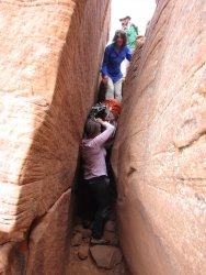
Pretty sure my pic is 150 feet below and behind you two, Will. Looking back up. Just further down on the route. My guess is the feature you are standing in is the one that gave the route the "crack" name

This pic is right where you are:

IMG_1210.JPG
 
I'll just say, having done Coyote in both the high season and the depths of winter, that much of the magic of Coyote is lost if you go in the off-season. The great thing about Coyote is the incredible lush green juxtaposed against the red rock, and you just don't get that in the off-season. All things being equal, I'd go in the fall, midweek.
 
I know the backcountry is about solitude (and I usually revel in that myself) but a huge part of my personal experience of Coyote Gulch was the variety of people I met in there. I did a very short overnight, but met some very interesting characters in my ~24 hours in the canyon and that's part of why I loved the experience so much. That said, I'd love to go back and extend it to a Stevens/Fold or something similar to get both Coyote and some more "solitary" areas of Escalante someday. Don't have anything else to add here other than that, unfortunately.
 
Last edited:
Pretty sure my pic is 150 feet below and behind you two, Will. Looking back up. Just further down on the route. My guess is the feature you are standing in is the one that gave the route the "crack" name

This pic is right where you are:

View attachment 88587

So your pic was of a descent direct down to the Escalante River then? Because as far as accessing Coyote Gulch itself, I only remember a descent down a huge sand dune from the actual crack off the rim down to the stream bed in the gulch. Hence my confusion.
 
I was just there last week, and maybe I am rehashing, so apologize. The initial drop in the crack is @WasatchWill's pic (2 below), and then there is a little opening and then a little scurry under the overhang and another drop in the crack to the dune.
Or as @John Morrow did, instead of going through that other tighter crack, you can downclimb the outside the last bit down and then you are on the dune (1 below).
Maybe that helps clarify?

The packrafters coming out ahead of us stayed entirely on the outside of the crack with their packs on the entire time.
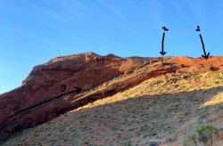
As well, a note. Two of that group of packrafters ahead of us dropped down to the left of the crack and then just walked with a little bit of scramble from the left and met up with the others climbing the crack (3 below). I am tempted to check out that route, if I am there again. Those two hikers were faster than their buddies coming from climbing the normal "crack" itself.
InkedIMG_3595_LI.jpg
 
I was just there last week, and maybe I am rehashing, so apologize. The initial drop in the crack is @WasatchWill's pic (2 below), and then there is a little opening and then a little scurry under the overhang and another drop in the crack to the dune.
Or as @John Morrow did, instead of going through that other tighter crack, you can downclimb the outside the last bit down and then you are on the dune (1 below).
Maybe that helps clarify?

The packrafters coming out ahead of us stayed entirely on the outside of the crack with their packs on the entire time.
As well, a note. Two of that group of packrafters ahead of us dropped down to the left of the crack and then just walked with a little bit of scramble from the left and met up with the others climbing the crack (3 below). I am tempted to check out that route, if I am there again. Those two hikers were faster than their buddies coming from climbing the normal "crack" itself.
View attachment 88723

Ahhh...that might explain it. When we went down and back up through the crack, we stuck with staying in both the upper and lower crack because it seemed the most obvious (and most fun with the squeeze in the lower). I never knew there was any other non-technical way around it or halfway down through it that could bypass any section of it.
 
Back
Top