fossana
Member
- Joined
- Jan 11, 2018
- Messages
- 1,035
I don't normally do overnight trips, but decided to make an exception to explore the remote backcountry of southern UT. After much digging through Kelsey's and Allen's books, and inspired by John M's trip report, I settled on the Stevens/Fold Canyon loop in Glen Canyon. I upgraded my 10 year old backpack and tent, and booked some long overdue vacation time.
Logistics
Start/end: official is 40 Mile trailhead off of Hole in the Rock Road; I went from Lobo South (a.k.a. Coyote Gulch sneak route)
Mileage: ~50 miles
Difficulties: 5.0 chimney downclimb, other sections of class 3-4, exposure
Annoyances: much bushwhacking/boulder hopping, poison ivy
Elevation gain: a handful of big climbs, but a lot of smaller ups and downs
Navigation: helpful to have a GPS since some of the landmarks aren't obvious
Filterable water: most canyons, but depends on the season
Permits: self-service permit for overnight permits at trailheads
Dogs: no
Nearest town/gas: Escalante, UT
Date hiked: 27-30 Oct 2018
On the headphones: Dirtbag Diaries podcast, Cadillac Desert
Approximate Route


Report
I had no idea how long the loop would take me with significant sections of dense brush, so I packed for 4 nights and got a leisurely (late) start from the south Lobo trailhead on Saturday. My choice to bump out a week after the storms turned out to be a good one since the frequently dry rim potholes were full. The forecast called for a slight chance of rain on Tuesday, but nothing like the torrential downpours like the week prior.

The sneak route takes a steep slap right next to Jacob Hamblin Arch, which is a spectacular way to enter the canyon.

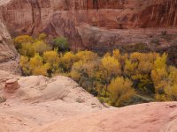
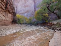
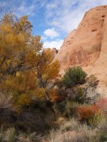
I had been through Coyote Gulch almost a year ago and this time it was busy (relatively speaking), so I didn't doddle. Last year the fall leaves were past peak, so I was happy to see the colors in full display, bright red poison ivy aside.

The Swiss Cheese Falls were as lovely as I remember.

I soon passed through Coyote Bridge and then Cliff Arch.


There was a large group at the 40 Mile trailhead junction, but afterward I saw no other people for days. The Escalante River was deep in spots, and more than once I started to get sucked into a quicksand trap. Thankfully that river portion was short and after passing Stevens Arch I started looking for the Stevens Canyon junction.


Lower Stevens Canyon was a mix of easy slickrock walking, scrambling and poison ivy dodging. Fortunately the notorious poison ivy dirt scramble had a cleared path to avoid most of the ivy.


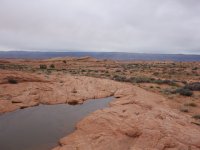
I kept my eye out for the pour-off/grotto near the ramp leading up to the canyon rim, and decided to camp nearby to be able to top off my water in the morning.

The rim walk was a pleasant change. The only disappointing part was that the sun wasn't high enough to capture the canyon in all of its glory. The route crossed back into the canyon. The recent rains made the travel easy over the sandy wash. I passed the 3-way junction and Baker Trail exit. Someone had recently passed this way.


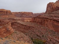
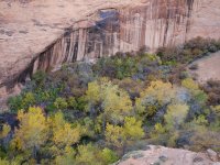
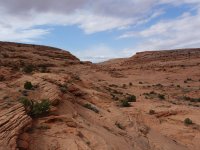
Upper Stevens Canyon on the other hand, was not so pleasant. When possible I followed deer and human trails through the thick Phragmites grass, shrubs, and horsetails but at times had to fight my way through. The going was slow. Finally the canyon opened up again. The recent tracks were gone. I passed the pioneer graffiti boulder marking an old mining claim and started to look for the canyon exit. The climb out was mossy and the rock was extra fragile with the rains.

I continued along the rim of Stevens Canyon, planning to get as close as possible to Fold Pass before dark. I was hoping by staying out of the canyon bottom my tent would have a chance to dry out. I found a spot free from cryptobiotic soil and settled in. I woke up in time for a stunning sunrise.


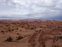
Then I headed up toward the pass that would take me into Fold Canyon, and across the huge pour-off to the other rim.


I overshot the crucial mid-canyon crossing by a few minutes and had to backtrack briefly. The route continued down the left rim over mostly easy slickrock terrain, passing hidden grottos along the way.


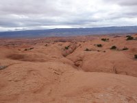
Finally I could see the walls of the Escalante River canyon and started to look for the pass that leads to the hidden downclimb. Skirting the side drainage took a while, but I didn't waste too much time locating the two cryptic arches that lead to the chimney exit. I followed drainages out to the river. John's map noted deep pools so I stuck to the banks when possible, which was a total slog with the dense willows and boulder hopping. I made it as far as the Fools Canyon entrance and stopped for the day.
In the morning I was greeted with overcast skies and more tedious Escalante River skirting. Fortunately, I only had a few river bends to pass before reaching the hidden Bobway exit, an old cattle route. Still, all open pockets of my pack were filled with willow leaves.


The exit out of the Bobway onto Les George Point a huge steep sand dune. Yet again I was thankful for the damp, firm sand.

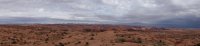
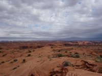
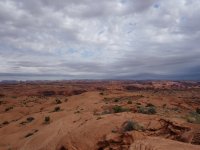
I headed across the plateau toward King Mesa. The dark clouds rolled in and it started to rain, fortunately lightly. I was glad to be done with the narrower slots part of my trip just in case, but picked up my pace to try to reach the trailhead by dark. My weather forecast was 3 days old, and I didn't want to get stuck in the canyons or on the road out if the rain picked up.


Fortunately, I never got hit with any heavy rain, and things started to clear as I got close to the King Mesa saddle that marks the top of the easier long branch of Sleepy Hollow.

I followed the undulating left rim of Sleepy Hollow for a while until I saw the walls of Coyote Gulch come into view.


I searched around for the log exit, hoping that the log was still there. It was, and I dropped into the canyon bottom.

I went into autopilot mode and headed for Jacob Hamblin Arch. Things were much quieter given that it was a Tuesday, so I only saw one party. When I reached the bottom of the sneak route I cleaned the sand off my shoes and headed up the slab. I made it back to my vehicle ~5:30pm, changed, grabbed a snack, and headed to Escalante Outfitters for pizza. Overall it was exactly what I needed.


Logistics
Start/end: official is 40 Mile trailhead off of Hole in the Rock Road; I went from Lobo South (a.k.a. Coyote Gulch sneak route)
Mileage: ~50 miles
Difficulties: 5.0 chimney downclimb, other sections of class 3-4, exposure
Annoyances: much bushwhacking/boulder hopping, poison ivy
Elevation gain: a handful of big climbs, but a lot of smaller ups and downs
Navigation: helpful to have a GPS since some of the landmarks aren't obvious
Filterable water: most canyons, but depends on the season
Permits: self-service permit for overnight permits at trailheads
Dogs: no
Nearest town/gas: Escalante, UT
Date hiked: 27-30 Oct 2018
On the headphones: Dirtbag Diaries podcast, Cadillac Desert
Approximate Route
Report
I had no idea how long the loop would take me with significant sections of dense brush, so I packed for 4 nights and got a leisurely (late) start from the south Lobo trailhead on Saturday. My choice to bump out a week after the storms turned out to be a good one since the frequently dry rim potholes were full. The forecast called for a slight chance of rain on Tuesday, but nothing like the torrential downpours like the week prior.
The sneak route takes a steep slap right next to Jacob Hamblin Arch, which is a spectacular way to enter the canyon.
I had been through Coyote Gulch almost a year ago and this time it was busy (relatively speaking), so I didn't doddle. Last year the fall leaves were past peak, so I was happy to see the colors in full display, bright red poison ivy aside.
The Swiss Cheese Falls were as lovely as I remember.
I soon passed through Coyote Bridge and then Cliff Arch.
There was a large group at the 40 Mile trailhead junction, but afterward I saw no other people for days. The Escalante River was deep in spots, and more than once I started to get sucked into a quicksand trap. Thankfully that river portion was short and after passing Stevens Arch I started looking for the Stevens Canyon junction.
Lower Stevens Canyon was a mix of easy slickrock walking, scrambling and poison ivy dodging. Fortunately the notorious poison ivy dirt scramble had a cleared path to avoid most of the ivy.
I kept my eye out for the pour-off/grotto near the ramp leading up to the canyon rim, and decided to camp nearby to be able to top off my water in the morning.
The rim walk was a pleasant change. The only disappointing part was that the sun wasn't high enough to capture the canyon in all of its glory. The route crossed back into the canyon. The recent rains made the travel easy over the sandy wash. I passed the 3-way junction and Baker Trail exit. Someone had recently passed this way.
Upper Stevens Canyon on the other hand, was not so pleasant. When possible I followed deer and human trails through the thick Phragmites grass, shrubs, and horsetails but at times had to fight my way through. The going was slow. Finally the canyon opened up again. The recent tracks were gone. I passed the pioneer graffiti boulder marking an old mining claim and started to look for the canyon exit. The climb out was mossy and the rock was extra fragile with the rains.
I continued along the rim of Stevens Canyon, planning to get as close as possible to Fold Pass before dark. I was hoping by staying out of the canyon bottom my tent would have a chance to dry out. I found a spot free from cryptobiotic soil and settled in. I woke up in time for a stunning sunrise.
Then I headed up toward the pass that would take me into Fold Canyon, and across the huge pour-off to the other rim.
I overshot the crucial mid-canyon crossing by a few minutes and had to backtrack briefly. The route continued down the left rim over mostly easy slickrock terrain, passing hidden grottos along the way.
Finally I could see the walls of the Escalante River canyon and started to look for the pass that leads to the hidden downclimb. Skirting the side drainage took a while, but I didn't waste too much time locating the two cryptic arches that lead to the chimney exit. I followed drainages out to the river. John's map noted deep pools so I stuck to the banks when possible, which was a total slog with the dense willows and boulder hopping. I made it as far as the Fools Canyon entrance and stopped for the day.
In the morning I was greeted with overcast skies and more tedious Escalante River skirting. Fortunately, I only had a few river bends to pass before reaching the hidden Bobway exit, an old cattle route. Still, all open pockets of my pack were filled with willow leaves.
The exit out of the Bobway onto Les George Point a huge steep sand dune. Yet again I was thankful for the damp, firm sand.
I headed across the plateau toward King Mesa. The dark clouds rolled in and it started to rain, fortunately lightly. I was glad to be done with the narrower slots part of my trip just in case, but picked up my pace to try to reach the trailhead by dark. My weather forecast was 3 days old, and I didn't want to get stuck in the canyons or on the road out if the rain picked up.
Fortunately, I never got hit with any heavy rain, and things started to clear as I got close to the King Mesa saddle that marks the top of the easier long branch of Sleepy Hollow.
I followed the undulating left rim of Sleepy Hollow for a while until I saw the walls of Coyote Gulch come into view.
I searched around for the log exit, hoping that the log was still there. It was, and I dropped into the canyon bottom.
I went into autopilot mode and headed for Jacob Hamblin Arch. Things were much quieter given that it was a Tuesday, so I only saw one party. When I reached the bottom of the sneak route I cleaned the sand off my shoes and headed up the slab. I made it back to my vehicle ~5:30pm, changed, grabbed a snack, and headed to Escalante Outfitters for pizza. Overall it was exactly what I needed.
Attachments
-
 DSC08862.jpg425.9 KB · Views: 129
 -
 DSC08868.jpg264.7 KB · Views: 118
 -
 DSC08887.jpg91.2 KB · Views: 117
 -
 DSC08912.jpg1.4 MB · Views: 104
 -
 DSC08917.jpg1.6 MB · Views: 105
 -
 DSC08923.jpg1.6 MB · Views: 93
 -
 DSC08933.jpg1.7 MB · Views: 90
 -
 DSC08889.jpg1 MB · Views: 81
 -
 DSC08889.jpg1 MB · Views: 76
 -
 DSC08896.jpg379.5 KB · Views: 75
 -
 DSC08898.jpg1.1 MB · Views: 75
 -
 DSC08904.jpg1.1 MB · Views: 78
 -
 DSC08912.jpg1.4 MB · Views: 75
 -
 DSC08917.jpg1.6 MB · Views: 77
 -
 DSC08923.jpg1.6 MB · Views: 80
 -
 DSC08933.jpg1.7 MB · Views: 96
 -
 DSC08912.jpg1.4 MB · Views: 228
Last edited: