hikeer
Member
- Joined
- Nov 2, 2019
- Messages
- 39
My daughter and I spent six days in the Beartooths in early August hiking from Island Lake cross country, eventually intersecting the Beaten Path, which we followed North as far as Impasse Falls, then back out the Path to the Clarks Fork trailhead.
Flew into Billings on Wednesday late afternoon, grabbed the rental car and headed for Cooke City. Easy trip with some outstanding scenery on the drive over the Beartooth Highway. Stayed at a cabin just before Cooke City I found on Airbnb. Headed into Cooke City the next morning under bluebird skies (a theme for the trip") ) to pick up a canister for the stove and some bear spray. Parked the rental car at the Clark's Fork trailhead and found a hitch over to Island Lake with a lady dropping her son and some friends off who were hiking the Beaten Path. She was from Georgia and spent her summers working in Yellowstone. Interesting conversation on her experiences working in one of the hotels.
) to pick up a canister for the stove and some bear spray. Parked the rental car at the Clark's Fork trailhead and found a hitch over to Island Lake with a lady dropping her son and some friends off who were hiking the Beaten Path. She was from Georgia and spent her summers working in Yellowstone. Interesting conversation on her experiences working in one of the hotels.
First day was an easy hike over to Flake Lake sitting underneath the Beartooth Plateau. We spent a lazy afternoon acclimatizing and wandering around the lake a bit. Passing clouds threatened rain that never came. The next morning we made our way up from Flake Lake to the Plateau, going up between Wall and Heart lakes. Nothing really steep, just a steady uphill grind to gain the plateau a couple thousand feet up. Spectacular views down to Glacier Lake, the plateaus beyond it, and really just 360* around. As you approach the end of the plateau, the whole range seems to open up in front of you and you can see for miles, all the way over to Yellowstone. Pretty epic in my book. The descent to Jasper Lake is quite steep in spots, I never felt really exposed but there were a couple of spots that I descended, dropped my pack and went up and carried my daughters pack down so she could descend a little more confidently without the weight. We worked our way down one section at a time, scouting ahead to make sure we didn't cliff out somewhere. We ended coming down beside the waterfall and worked our way around the lake and camped on the far side in a great spot just above a small tarn. This down climb is a a little sketchy depending on your comfort level but very doable if you pick the correct route. This day was beautiful, just a few puffy clouds and it never threatened rain, although we did hear some thunder after dark.
Glacier Lake far below.

Better than my typical lunch view!

Jasper Lake and all the terrain we would be walking through for the next four days

Coming down past the waterfall above Jasper Lake

The next morning dawned bright and clear, as it would every morning of our hike. This day took us past Triskele Lake, Cloverleaf Lakes (minor navigation error!) and past Donelson and Maryott Lakes. Passed a party of four who were fishing at Maryott Lake, they would be the last people we saw until we intersected the Beaten Path. After Maryott, we stopped and ate breakfast overlooking Crystal Lake. A little steep coming down here, but we headed right (north) of the creek and found an easy mostly grass covered down climb towards the Pleiades lakes. This is a simply outstanding area, I could easily spend a few days just hanging out in this valley. Alp Lake, Crystal Lake, the Pleiades lakes, waterfalls, wildflowers, nice size creek, you name it, this little area has it all! We made a slight route change from the original plan of going up by Flat Rock and Copepod lakes so that we could check out the 1/4 mile long cascade waterfall coming down into Summerville Lake. Pretty cool waterfall with a nice view as we hiked up towards Erratic Lake. After a bit of map consulting, we settled on going left around Erratic lake, which turned out to be a good decision and we hiked up to Robble Lake, where we found a nice campsite. We were pretty tired but enjoyed a nice evening swatting skeeters, which were plentiful here, and tiptoeing around barefoot so our shoes would dry. Here is also where the 2nd of my four Opsak odor proof bags failed. Both bags that failed just came apart at the seam below the closure. So much for being odorproof. At least they did send me replacements at no charge when I called them later and explained the issue.
Crystal and the Pleiades lakes with Castle Lake in background:

Alp Lake: I did a full-on face plant right behind where my daughter is standing when I caught my toe on a rock - luckily the most grass of anywhere we hiked all week!

Pretty, pretty...

Opsak failure:

Camp at Robble Lake - must not have had my phone level as the ground under the tent was more level than it appears in this picture:

The next morning, we headed past Till and Gravel Lakes towards Big Butte Lake. Only one other group of three had been up in this area judging by the tracks. Ate breakfast overlooking Big Butte Lake towards Desolation Lake. At Desolation, we turned north and traversed through the high country over to Red Rock Lake. Lots of snowbanks up here and Red Rock Lake was still partially frozen over. Pretty sure we were the first backpackers in this area for the year as there were no tracks anywhere that we saw, including the natural chokepoints. I worried too much this day about getting down to Gallery Lake as it seemed it would be steep in any direction. In addition, earlier that day coming up from Desolation Lake, the route I had marked in one area was impassable due to a steep snow wall blocking the whole pass. We were able to find an alternate way around it without issue, but my nerves were a little on edge all day. However, once we started down from Red Rock Lake, we were able to follow the outlet creek (being careful to avoid walking on the snow that covered the water in some places) that drops down to Gallery Lake until we hit a waterfall with an overhanging snow bank that forced us to climb up and descend the nose of the mountain, which actually turned out to be much easier. We found a superb spot to camp close to the saddle between Gallery Lake and Lake of the Winds and managed to get dinner in just before a storm blew in.
Breakfast at Big Butte(Lake):

She-who-walks-on-water

Off-trail in the Beartooths:

A little bit of snow still left up here...

Red Rock Lake

Heading down the outlet creek from Red Rock Lake:

Camp in the middle of God's glory

Once again, blue skies without a hint of clouds greeted us the next morning. Ate breakfast at camp this morning and moved out for the short trip up and over a couple small passes towards Fossil Lake. One more steep climb down to an unnamed lake east of Fossil Lake. Walking along the shores of this lake we stirred up apocalyptic hordes of mosquitoes. My daughter has a bit of a phobia about mosquito's since she tends to have pretty bad reactions to being bitten, often getting golf ball size lumps at the site. She had her headnet on but was still on the verge of hyperventilating walking through the dense clouds of mosquito's. They weren't really aggressive however and no damage was done. We intersected the Beaten Path late morning and celebrated by getting our picture taken by a passing group. We proceeded north on the path as far as Impasse Falls before tracing our steps back to Dewey Lake where we made camp. We hung out on the shores of the lake for most of the late afternoon just taking in the views and enjoying a nice breeze that kept the bugs at bay. Incredibly peaceful to just sit and look out over the gorgeous lake with its backdrop of snow streaked mountains.
Unnamed lake with Fossil Lake and Granite Peak in the background:

Fossil Lake wildflowers:

We found a trail!

Lunch and a foot soak

Dewey Lake - probably the prettiest lake I've ever seen

Impasse Falls:

We got on the trail early the next morning for the twelve mile hike out to the trailhead. The scenery from Fossil Lake down to the Clark's Fork Trailhead is nice to start and then you progressively descend into the woods for some fairly ordinary hiking. Fizzle Lake down to Ouzel Lake is nice hiking but after that it's just laying down miles to get to the car. Hit the car about 2:30, headed back to Cooke City for showers and dinner at the Beartooth Cafe. Cool place and we would end up eating here again the next day. Spent the next day cruising around the northern parts of Yellowstone Park, including the Lamar Valley, Norris Geyser basin, and the Grand Canyon of the Yellowstone. Saw a black bear and lots of bison. We stopped back in Cooke City to eat, with intentions on trying Montasia, but they were closed so we hit up the aforementioned Beartooth Cafe again for burgers. Took the Chief Joseph highway back towards Red Lodge and really enjoyed it - very scenic. Spent the night in Red Lodge at a great B&B (Two Bears Inn) and headed back to Billings the next day to fly back home.
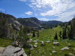
Typical scenery past Fossil Lake

Obligatory Wilderness sign pic

I really enjoyed this hike - it was definitely more difficult than the Winds, which we were in last year. It is much more rugged. The macro route finding is relatively straightforward but the micro route finding is quite complex. You are always scanning your map and the terrain in front of you to figure out how to get around a lake, over the next pass, etc. Lots of up and down, often steep, almost always rocky. The Winds (at least the part we were in) seem to be characterized more by big mountains and long, epic passes. If they were women, I'd say both are beautiful, the Winds in an almost elegant way while the Beartooths are a little more saucy and probably has a skull tattoo somewhere on her back. I'm in love with both...
Flew into Billings on Wednesday late afternoon, grabbed the rental car and headed for Cooke City. Easy trip with some outstanding scenery on the drive over the Beartooth Highway. Stayed at a cabin just before Cooke City I found on Airbnb. Headed into Cooke City the next morning under bluebird skies (a theme for the trip
) to pick up a canister for the stove and some bear spray. Parked the rental car at the Clark's Fork trailhead and found a hitch over to Island Lake with a lady dropping her son and some friends off who were hiking the Beaten Path. She was from Georgia and spent her summers working in Yellowstone. Interesting conversation on her experiences working in one of the hotels.First day was an easy hike over to Flake Lake sitting underneath the Beartooth Plateau. We spent a lazy afternoon acclimatizing and wandering around the lake a bit. Passing clouds threatened rain that never came. The next morning we made our way up from Flake Lake to the Plateau, going up between Wall and Heart lakes. Nothing really steep, just a steady uphill grind to gain the plateau a couple thousand feet up. Spectacular views down to Glacier Lake, the plateaus beyond it, and really just 360* around. As you approach the end of the plateau, the whole range seems to open up in front of you and you can see for miles, all the way over to Yellowstone. Pretty epic in my book. The descent to Jasper Lake is quite steep in spots, I never felt really exposed but there were a couple of spots that I descended, dropped my pack and went up and carried my daughters pack down so she could descend a little more confidently without the weight. We worked our way down one section at a time, scouting ahead to make sure we didn't cliff out somewhere. We ended coming down beside the waterfall and worked our way around the lake and camped on the far side in a great spot just above a small tarn. This down climb is a a little sketchy depending on your comfort level but very doable if you pick the correct route. This day was beautiful, just a few puffy clouds and it never threatened rain, although we did hear some thunder after dark.
Glacier Lake far below.
Better than my typical lunch view!
Jasper Lake and all the terrain we would be walking through for the next four days
Coming down past the waterfall above Jasper Lake
The next morning dawned bright and clear, as it would every morning of our hike. This day took us past Triskele Lake, Cloverleaf Lakes (minor navigation error!) and past Donelson and Maryott Lakes. Passed a party of four who were fishing at Maryott Lake, they would be the last people we saw until we intersected the Beaten Path. After Maryott, we stopped and ate breakfast overlooking Crystal Lake. A little steep coming down here, but we headed right (north) of the creek and found an easy mostly grass covered down climb towards the Pleiades lakes. This is a simply outstanding area, I could easily spend a few days just hanging out in this valley. Alp Lake, Crystal Lake, the Pleiades lakes, waterfalls, wildflowers, nice size creek, you name it, this little area has it all! We made a slight route change from the original plan of going up by Flat Rock and Copepod lakes so that we could check out the 1/4 mile long cascade waterfall coming down into Summerville Lake. Pretty cool waterfall with a nice view as we hiked up towards Erratic Lake. After a bit of map consulting, we settled on going left around Erratic lake, which turned out to be a good decision and we hiked up to Robble Lake, where we found a nice campsite. We were pretty tired but enjoyed a nice evening swatting skeeters, which were plentiful here, and tiptoeing around barefoot so our shoes would dry. Here is also where the 2nd of my four Opsak odor proof bags failed. Both bags that failed just came apart at the seam below the closure. So much for being odorproof. At least they did send me replacements at no charge when I called them later and explained the issue.
Crystal and the Pleiades lakes with Castle Lake in background:
Alp Lake: I did a full-on face plant right behind where my daughter is standing when I caught my toe on a rock - luckily the most grass of anywhere we hiked all week!
Pretty, pretty...
Opsak failure:
Camp at Robble Lake - must not have had my phone level as the ground under the tent was more level than it appears in this picture:
The next morning, we headed past Till and Gravel Lakes towards Big Butte Lake. Only one other group of three had been up in this area judging by the tracks. Ate breakfast overlooking Big Butte Lake towards Desolation Lake. At Desolation, we turned north and traversed through the high country over to Red Rock Lake. Lots of snowbanks up here and Red Rock Lake was still partially frozen over. Pretty sure we were the first backpackers in this area for the year as there were no tracks anywhere that we saw, including the natural chokepoints. I worried too much this day about getting down to Gallery Lake as it seemed it would be steep in any direction. In addition, earlier that day coming up from Desolation Lake, the route I had marked in one area was impassable due to a steep snow wall blocking the whole pass. We were able to find an alternate way around it without issue, but my nerves were a little on edge all day. However, once we started down from Red Rock Lake, we were able to follow the outlet creek (being careful to avoid walking on the snow that covered the water in some places) that drops down to Gallery Lake until we hit a waterfall with an overhanging snow bank that forced us to climb up and descend the nose of the mountain, which actually turned out to be much easier. We found a superb spot to camp close to the saddle between Gallery Lake and Lake of the Winds and managed to get dinner in just before a storm blew in.
Breakfast at Big Butte(Lake):
She-who-walks-on-water
Off-trail in the Beartooths:
A little bit of snow still left up here...
Red Rock Lake
Heading down the outlet creek from Red Rock Lake:
Camp in the middle of God's glory
Once again, blue skies without a hint of clouds greeted us the next morning. Ate breakfast at camp this morning and moved out for the short trip up and over a couple small passes towards Fossil Lake. One more steep climb down to an unnamed lake east of Fossil Lake. Walking along the shores of this lake we stirred up apocalyptic hordes of mosquitoes. My daughter has a bit of a phobia about mosquito's since she tends to have pretty bad reactions to being bitten, often getting golf ball size lumps at the site. She had her headnet on but was still on the verge of hyperventilating walking through the dense clouds of mosquito's. They weren't really aggressive however and no damage was done. We intersected the Beaten Path late morning and celebrated by getting our picture taken by a passing group. We proceeded north on the path as far as Impasse Falls before tracing our steps back to Dewey Lake where we made camp. We hung out on the shores of the lake for most of the late afternoon just taking in the views and enjoying a nice breeze that kept the bugs at bay. Incredibly peaceful to just sit and look out over the gorgeous lake with its backdrop of snow streaked mountains.
Unnamed lake with Fossil Lake and Granite Peak in the background:
Fossil Lake wildflowers:
We found a trail!
Lunch and a foot soak
Dewey Lake - probably the prettiest lake I've ever seen
Impasse Falls:
We got on the trail early the next morning for the twelve mile hike out to the trailhead. The scenery from Fossil Lake down to the Clark's Fork Trailhead is nice to start and then you progressively descend into the woods for some fairly ordinary hiking. Fizzle Lake down to Ouzel Lake is nice hiking but after that it's just laying down miles to get to the car. Hit the car about 2:30, headed back to Cooke City for showers and dinner at the Beartooth Cafe. Cool place and we would end up eating here again the next day. Spent the next day cruising around the northern parts of Yellowstone Park, including the Lamar Valley, Norris Geyser basin, and the Grand Canyon of the Yellowstone. Saw a black bear and lots of bison. We stopped back in Cooke City to eat, with intentions on trying Montasia, but they were closed so we hit up the aforementioned Beartooth Cafe again for burgers. Took the Chief Joseph highway back towards Red Lodge and really enjoyed it - very scenic. Spent the night in Red Lodge at a great B&B (Two Bears Inn) and headed back to Billings the next day to fly back home.
Typical scenery past Fossil Lake
Obligatory Wilderness sign pic
I really enjoyed this hike - it was definitely more difficult than the Winds, which we were in last year. It is much more rugged. The macro route finding is relatively straightforward but the micro route finding is quite complex. You are always scanning your map and the terrain in front of you to figure out how to get around a lake, over the next pass, etc. Lots of up and down, often steep, almost always rocky. The Winds (at least the part we were in) seem to be characterized more by big mountains and long, epic passes. If they were women, I'd say both are beautiful, the Winds in an almost elegant way while the Beartooths are a little more saucy and probably has a skull tattoo somewhere on her back.
I'm in love with both...Attachments
Last edited: