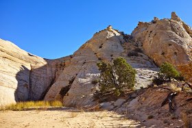
Anxious About Escalante

... the great and the good of the hiking community, who are normally hibernating at this time of year, have peeked out of their respective 4-season sleeping bags to provide you with some amazing advice for your trip ... it looks like a fantastic adventure.

I'm not sure if this is literally your first trip to the South-West. If so, can I suggest that you use your 14 days to visit the National Parks and assorted highlights of the area; doing big day-hikes and perhaps a couple of short overnight backpacks. I realize that the potential crowds put people off, who are looking for a more wilderness experience, but for anyone willing to hike more than a couple of miles from an established trailhead, you're very likely to have the place to yourself for most of the time. It goes without saying that the scenery and hiking possibilities in Arches, Canyonlands, Capitol Reef, Bryce, and Zion are quite stupendous.
That "amazing advice" is what brought me to BCP originally.
I'll second what @TrailScot has to say about checking out some of the highlights of the region even if it means more people, both for the scenic value and as an easygoing intro to the desert environment. I know that many including ourselves are particularly fond of the Needles district in Canyonlands, where there are backpacking opportunities as well. (although maybe hard to book?)
 
I've been to Choprock twice now. Hiking in Choprock canyon itself is very easy and pleasant - like you said, unless you're looking for extra. The real issue will be the Escalante. If its running high (impossible to predict), then getting up and down it even for short stretches can be pretty miserable. Much of this will come down to your style and preference. If you consider a bit of tough slogging and bushwhacking all part of the adventure (that's me) then you'll certainly be fine down there. But if you think that's the kind of thing that would ruin your trip, you can still do Choprock, but you'll want to avoid the Escalante. I was there once in very early April (the 1st or 2nd I believe) and the river was crazy high - I still loved my trip, but, my god, the mud! Crossed the river right at Choprock on my way to Neon, decided to cross back a few hundred yards downriver and with my first step I sunk in above my knee. I laughed at my stupidity (should have checked with my hiking pole first), went on my way and loved my trip. It can get very cold that time of year - below freezing and you may be wet, so be prepared. Early October would be wonderful there. By the way, just to show you how fickle that river can be, two days later (I was hiking up the Escalante) the river was down to perfectly normal levels, so don't think that early April = High River. I checked out Bob's video and those are perfectly normal river levels - what you could expect most of the time.

The trip that Bob describes is the purple loop on the map that radioradio posted,. That is a great way to go. There is dirt road access (Moody Creek Rd) at the east of that loop and easy parking (assuming the weather hasn't been crappy). You could start there, hike down Choprock (8-9 miles to the river I believe) and if the Escalante is more than you bargained for you could easily backtrack and have a nice one or two nights in Choprock. Crossing the river and camping near Neon sounds like a wonderful idea to me, but there isn't a lot to do down there. Ringtail is nice to go poke your head into, but you can't get very far in without it getting technical (that is from memory, so double check that). You also might want to look into heading west (plenty of trails up that way), to Egypt Road and check out either Egypt Canyon or Egypt Slot, but I have no personal knowledge of those - just on my to do list.

You also asked about water. It will likely be mostly dry in both Choprock and Silver Falls until you get down pretty close to the Escalante, so if you do the route I suggested make sure you leave with plenty of water, and have a filter for water down lower. There are some springs, but just more convenient to have filter in my opinion.

Hope that helps!
 
not sure what you consider interesting but while poking around this route in google earth it's easy to spot a constructed trail escaping Choprock to the south just a little bit above where it runs into the Escalante, this would be a nice way to get some view, get out of the cold air pool, etc.
Yes but then you miss some nice narrows and above the narrows it's a nice canyon
 
I've been to Choprock twice now. Hiking in Choprock canyon itself is very easy and pleasant - like you said, unless you're looking for extra. The real issue will be the Escalante. If its running high (impossible to predict), then getting up and down it even for short stretches can be pretty miserable. Much of this will come down to your style and preference. If you consider a bit of tough slogging and bushwhacking all part of the adventure (that's me) then you'll certainly be fine down there. But if you think that's the kind of thing that would ruin your trip, you can still do Choprock, but you'll want to avoid the Escalante. I was there once in very early April (the 1st or 2nd I believe) and the river was crazy high - I still loved my trip, but, my god, the mud! Crossed the river right at Choprock on my way to Neon, decided to cross back a few hundred yards downriver and with my first step I sunk in above my knee. I laughed at my stupidity (should have checked with my hiking pole first), went on my way and loved my trip. It can get very cold that time of year - below freezing and you may be wet, so be prepared. Early October would be wonderful there. By the way, just to show you how fickle that river can be, two days later (I was hiking up the Escalante) the river was down to perfectly normal levels, so don't think that early April = High River. I checked out Bob's video and those are perfectly normal river levels - what you could expect most of the time.

The trip that Bob describes is the purple loop on the map that radioradio posted,. That is a great way to go. There is dirt road access (Moody Creek Rd) at the east of that loop and easy parking (assuming the weather hasn't been crappy). You could start there, hike down Choprock (8-9 miles to the river I believe) and if the Escalante is more than you bargained for you could easily backtrack and have a nice one or two nights in Choprock. Crossing the river and camping near Neon sounds like a wonderful idea to me, but there isn't a lot to do down there. Ringtail is nice to go poke your head into, but you can't get very far in without it getting technical (that is from memory, so double check that). You also might want to look into heading west (plenty of trails up that way), to Egypt Road and check out either Egypt Canyon or Egypt Slot, but I have no personal knowledge of those - just on my to do list.

You also asked about water. It will likely be mostly dry in both Choprock and Silver Falls until you get down pretty close to the Escalante, so if you do the route I suggested make sure you leave with plenty of water, and have a filter for water down lower. There are some springs, but just more convenient to have filter in my opinion.

Hope that helps!
Great info - I want to do this!
 
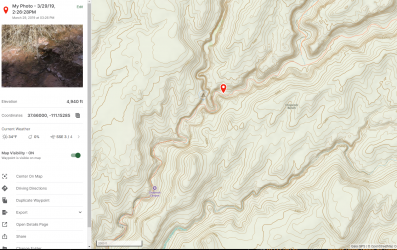
From the archives - I marked the spot in Choprock where water starts to flow. Crappy picture, and coordinates! (on the left). Gave you some bad info when I said no water until near the Escalante. It's a trickle but it will do!
 
From the archives - I marked the spot in Choprock where water starts to flow. Crappy picture, and coordinates! (on the left). Gave you some bad info when I said no water until near the Escalante. It's a trickle but it will do!
I see this was dated March 29, 2019. I forget if that was a high snowpack winter. I wonder how different it would be in a different year and in other months, such as October.
 
October 2021, it started just below where the North Fork branches off and was probably only a few hundred meters from what that mapped showed.
 
I'm not sure if this is literally your first trip to the South-West. If so, can I suggest that you use your 14 days to visit the National Parks and assorted highlights of the area; doing big day-hikes and perhaps a couple of short overnight backpacks. I realize that the potential crowds put people off, who are looking for a more wilderness experience, but for anyone willing to hike more than a couple of miles from an established trailhead, you're very likely to have the place to yourself for most of the time. It goes without saying that the scenery and hiking possibilities in Arches, Canyonlands, Capitol Reef, Bryce, and Zion are quite stupendous.
While I strongly agree with the consensus here (namely, that it would probably be a lot better to do a sequence of shorter trips as opposed to a long trip), I also think pushing it too far the other way and doing day-hikes in national parks would be a lot less fun (for me anyway). On a few occasions I have cut backpacking trips short to fit in must-do day-hikes in the region, and I've regretted it in every case. I personally just enjoy backpacking way more. But for most people, the sweet spot for trip length in a new region would probably be in the 2-5 day range (3-4 day trips are really nice!), for the reasons LarryBoy outlined above.
 
Janice,
I don't remember what snowpack was like that year. I camped in the poison ivy fork of Choprock the night that picture was taken, so I would have hit the Escalante on the afternoon of the 30th, and for some reason I remember not being surprised that it was up, so maybe there had been some recent rain? But I was surprised at just how high and fast it was running. Actually put a bit of a scare into me because this was a thru-hike - I didn't have a spectacular exit strategy - and I was going to have to hike upstream the next day. That would have been the 31st and the river had already come down quite a bit - not to normal, it was a tough upstream hike. But by the time I left the Escalante behind (April 1) I'd say the level was normal. So whatever was going on was a pretty short term phenomenon. For what it's worth I do almost all my hiking in southern Utah in either April or October (nearly every year, sometimes both!) I really don't think there is much of a difference - temperatures about the same. You may slightly improve your chances regarding river levels by going in October. March 2019 was the only time anything like that has happened to me. Hit some very deep water once in the upper Escalante, but that was because some beavers had built a dam - no accounting for that. Also, just to reiterate about temperatures that time of year, the night of the 30th, after getting completely wet on my side hike to Neon, I set my socks on top of my tent hoping they'd dry at least a little bit. I have a pretty funny picture of them frozen stiff.
So interesting and helpful - thanks. Let's see that photo!

@radioradio - I'm so glad you put out this query. I've learned a ton! :)
 
While I strongly agree with the consensus here (namely, that it would probably be a lot better to do a sequence of shorter trips as opposed to a long trip), I also think pushing it too far the other way and doing day-hikes in national parks would be a lot less fun (for me anyway). On a few occasions I have cut backpacking trips short to fit in must-do day-hikes in the region, and I've regretted it in every case. I personally just enjoy backpacking way more. But for most people, the sweet spot for trip length in a new region would probably be in the 2-5 day range (3-4 day trips are really nice!), for the reasons LarryBoy outlined above.
I generally agree with RyanP's point about dayhikes in national parks, but in Capitol Reef, the Upper Muley Twist Trail is an exception. It has fantastic views of the Waterpocket Fold and the Henry Mountains, and it crosses some very diverse terrain. It's sufficiently remote and long that it doesn't get a ton of visitation.
 
Thanks all for this incredible feedback! I am humbled by and appreciative of this community. It's so rare to find a group of people who know so much and are also generous with that knowledge.

I am regrouping and going back to the drawing board on this trip to try to balance safety and joy with remoteness and ambition.

This may be the only opportunity I have for a trip of this length any time in the next bunch of years. Getting off the grid for an extended period of time is the top priority for this trip. I'm willing to trade off most things for this.

That said, it's clear that my initial trip was WAYYY too ambitious.

It seems my choices are either to a) look at other destinations to accomplish my goal of a 10-14 night jaunt in april or b) tone down my escalante ambitions like so:

1. Start with a shorter 2-3 day trip to shakeout my gear, understand the area and adjust my plans for a longer trip. Right now I'm looking at an out and back on the Boulder Mail Trail as a good representation of the area.
2. Do a version of this trip from doingmiles (click for link). They did it in 6 days. My plan would be to set aside 10 days. I would make a small modification to hike Little Death Hollow instead of wolverine canyon.

My intention is to cache food (and water) at the Lower Gulch Trailhead and water at spencer flats road.

If I'm not feeling great, I can arrange a shuttle from The Lower Gulch, Wolverine or Phipps Arch Trailhead with my PLB (or my emergency contact can).

If I'm making good time, there are lots of opportunities to day hike and double up at a campsite.

It seems like the major cruxes of this route are:
1. the long dry stretches–particularly from phipps wash to the harris wash trailhead
mitigate with water cache at spencer flats road, 8L carrying capacity
2. route finding between red breaks and the escalante and harris wash and the escalante
mitigate with google earth research, caltopo on my phone, printed maps + compass
3. obstacles in the gulch, red breaks and big horn canyons
mitigate with intel, webbing/rope to lift a pack, extreme caution

Here are my open questions:
1. Is this still too ambitious? Is there another part of the world where I can more safely plan a 10-14 day trip in April?
2. @Bob why do you carry webbing not rope? what kind of webbing?
3. Does anyone have beta on the obstacles mentioned above? Are there major obstacles I'm missing?
4. The guidebooks I have seem to say that Death Hollow is some of the most intense hiking in the area. As such, I was skipping it on my warm up trip. Would y'all agree?
5. @priz1234 do you have a sense if going one direction or the other through the gulch would be easier?
6. @MikeP I'd love your big horn canyon intel.

PS: sorry it took so long to respond to all of this, I was digesting and figuring out a plan...
 
Webbing is flat and takes less space. You never know when something in a narrow canyon changes or you get cliffed out, having webbing lets you lower packs or even yourself. You can leave it to get back up something as well. Climbers webbing, like 1 in wide.

The upper part of Death Hollow from the road to the Boulder Mail trail is the hard part. From the Mail trail to the river isnt bad, unless high water. Death Hollow and Little Death Hollow are different.
 
I would make a small modification to hike Little Death Hollow instead of wolverine canyon.
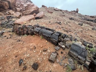
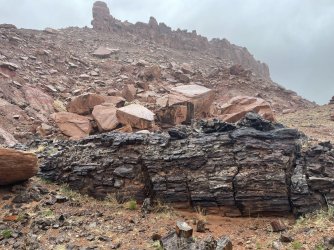
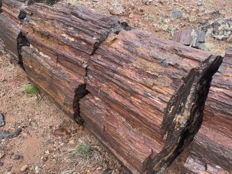
I agree that hiking all of LDH is a great idea. If you end up at the Wolverine TH (depending on how you go) and have time, consider doing a short out-and-back to see the amazing petrified wood there - huge logs in slices. It's less than a mile from the TH.
IMG_2785.jpg IMG_2789.jpg

IMG_2788.jpg
 
do you have a sense if going one direction or the other through the gulch would be easier?
I think going down the gulch would be easier. The drop in that canyon that is the major obstacle is one of those where I think it would be much easier going up than down. Probably still doable to go down but you would definitely want to lower your pack down first and would be easier if you had some webbing for you to hold onto as you go down as well. Problem is I don't think there was really anything you could loop some webbing around at the top of the climb. Looking at this photo from Road Trip Ryan's site it doesn't look like there is.


The easiest way up is basically right where that log is but that log that is leaning up the wall is no longer there. At least it there wasn't in 2021.
 
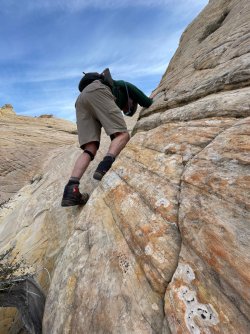
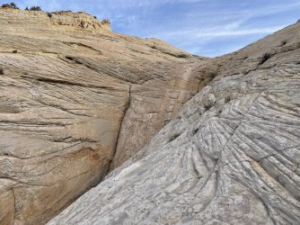
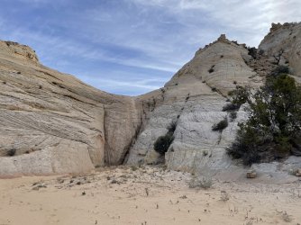
I'd love my Big Horn Intel too! My wife decided to "clean up" up the computer which evidently meant deleting an entire folder of pictures from one of my trips - in case you can't tell I'm still pretty angry about it. Still trying to recover. In the meantime, I'll have to use someone else's. The picture below is Jamal Green's. He calls this a "minor obstacle" and it is if you know the trick. I didn't and first tried to friction climb the slickrock on the near right. I felt the very close presence of the Angel of Death and backed away. Look to the very far right of this picture - that is where you want to be. I intentionally took a picture from further away to show this more clearly - and now I can't find it. You'll see a notch with a couple of trees (one looks dead). This is mostly soft dirt with a bunch of boulders (dislodging one would be very easy). Anyway, that ramp runs down pretty far and you can access it from about 50-75 yards from behind where this picture was taken. Very easy scramble really, but tough to spot (took me a good 15 minutes I'm embarrassed to say). You'll notice that this route will take you well above where you need to be to clear the dry fall.

Big Horn Obstacle.jpg

I point this out because if you're coming in the other direction this bypass ramp is even harder to spot. Below is another one of Jamal's pictures - this time from the top of the dry fall. Again, backing up a few dozen yards, you would scramble up to the left to get to the ramp I described. Very unintuitive to climb up to get down, but that is exactly what you want to do.

Big Horn Obstacle Two.jpg

Hope that helps.

As Bob has pointed out Death Hollow and LDH are different. Death Hollow is pretty easy, but you will get wet. Canyon narrows at one point and it could even be a short swim, but don't let that dissuade you - we're talking a few feet. Local legend has it this can be skirted by hugging one of the cliffs but I'd have to see it to believe it, especially with a big pack on. I just walked through the middle - high chest deep briefly.

Route finding between Red Breaks and the Escalante won't be much trouble unless you're a particularly bad route finder, in which case you shouldn't go. I suppose you could wander off into a branching part of the wash, but you'd realize your mistake pretty quickly I'd think.

Red Breaks would need to be done as a side hike - no big pack in there. If you're thinking about doing the entirety of Red Breaks solo I'd have to recommend against it. It can be done, because I did it, but it is seriously difficult, and I rank it among the dumbest things I've done. Very easy to get hurt in there, and if you do...boy are you in trouble. Satellite phone will not help you in a slot canyon - especially one like that. But even hiking back to the first big chockstone is worthwhile. Very cool slot canyon.
 
Local legend has it this can be skirted by hugging one of the cliffs but I'd have to see it to believe it
Are you talking about this spot?
1674492323975.png

We successfully got around it by waddling along a little ledge on the left. Ledge was under an inch of water or so, with an angled rock overhang only a few feet above. Not worth it, overall. I've seen pictures of people standing there where the water pours over with it only knee to thigh deep.

If you're talking about a different spot then disregard all of that haha.
 
  • Like
Reactions: Bob
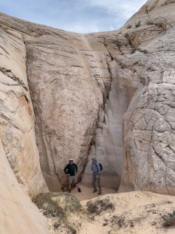
With smart, skilled @rwfrenchjr leading the way, we went down Big Horn's dryfall slickrock and fortunately didn't feel the Angel of Death's presence. :)
IMG_1635.jpg

IMG_1641.jpg

Cool view midway down
IMG_1644.jpg

View from the bottom - the ramp that @MikeP refers to is partly visible on the right
IMG_1656.jpg

Once we were safely down, it was fun to check out the dryfall from underneath. Such a cool spot!
IMG_1649.jpg

This is not my photo, but it shows the ramp quite well.
DSC06365.jpg
 
1 inch tubular webbing is what you want, they should be able to cut you any length at REI or whatever. this stuff is STRONG and not expensive and as Bob says it packs up well. also maybe a biner or two. I carry a 50' length of this even on the most innocuous trips, cheap insurance!

As people are saying, need to be very clear on Death Hollow vs Little Death Hollow. Both are great but for 100% sure don't do a top-down of Death Hollow on your first trip to the area, that would be a big mistake. Little Death Hollow (next to Wolverine) is top-notch, absolutely excellent.
 
Similar threads
Thread starter Title Forum Replies Date
B Is there water at Colt Mesa tank - Escalante Trip Planning 6
desertvic The Grand Staircase Escalante NM needs you! Meet Up (Members Only) 1
TrailScot Hole-in-the-Rock Road - Escalante General Discussion 11
G Escalante area 4-5 night backpack trip suggestions in late September. Loop if possible. Limit technical sections if any. Thanks! Backpacking 6
canadug Escalante area exploring Trip Planning 0
TrailScot Escalante Loop via Dry Hollow and Boulder Mail Trail - September 2023 Backpacking 8
Kullaberg63 Suggestions for Escalante east of river, south of Choprock Trip Planning 4
fossana A challenging week on the Escalante Overland Route Backpacking 21
fossana Public comment for revised Grand Staircase Escalante NM management plan (comments open 11 Aug - 9 Nov) General Discussion 11
BJett Part 3 - Tour de Canyon Country. Lower Escalante Loop Hiking & Camping 0
radioradio Sad Cowboy Traverse - A Week in Escalante Backpacking 12
F Upper Escalante River Backpack conditions Trip Planning 6
regehr Escalante dumpsters Trip Planning 9
regehr potable water in Escalante town? Trip Planning 6
D Fox Canyon Escalante? General Discussion 7
Janice Water questions - Escalante area Trip Planning 38
Duketogo13 BMT- Death Hollow-Escalante Triangle loop Trip Planning 20
Janice Cosmic Ashtray via Wolverine/Little Death Hollow & Escalante River? Trip Planning 16
Duketogo13 Questions about packrafting the Escalante/Lake Powell in September. Need help! Trip Planning 5
priz1234 The Gulch Escalante 4/17-4/18 Backpacking 2
RyanP Conditions (water/bugs) for Escalante/Death Hollow Trip Planning 27
J Escalante Natl. Mon. to Bryce N.P. the (unknown) Final Dayhikes April 15-16, 2021 Hiking & Camping 9
Bob Lost in the Escalante .......... Blast from the Past Backpacking 6
Bob A short Escalante trip end of April Backpacking 5
swmalone Restaurant Suggestions for Escalante or Boulder General Discussion 11
S Packrafting Escalante - FiftyMile Creek and low water level Lake Powell Trip Planning 8
swmalone Camping suggestions for Escalante in May Trip Planning 2
Muddy Waters Stevens, Fold, Escalante River, Fools, Kings Mesa Trip Reports 3
W 9 Days Solo Escalante Loop in October (water advice) - Stevens Canyon, Baker Route over Waterpocket fold, Halls Narrows to Moody Canyons Trip Planning 11
T Status of Traffic - Hole in the rock road - Escalante - September? Trip Planning 2
ramblinman Boulder Creek Day Hike, Escalante National Monument Hiking & Camping 5
M Ideas for 4 nights in Escalante Trip Planning 30
M Non-technical 1-2 night backpacking w dogs and kids - Escalante-ish area in April? Trip Planning 14
A 1st time backpacker in Escalante, UT Trip Planning 13
Stephanie B Grand Staircase Escalante National Monument - Kanab Area Hiking & Camping 2
Titans Permits car camping Grand Staircase Escalante NM? Trip Planning 6
Devin Ashby The Lower Gulch - Escalante (Seeking info on the route) Trip Planning 14
R Escalante River / Calf Creek Falls Current Conditions Trip Planning 10
cmgz Boulder Mail Trail - Escalante Trailhead to Mamie Creek Hiking & Camping 1
W Escalante River Backpacking Trip Planning 12
ADubs Looking for info from anyone who has done the Egypt loop and exited via 25mile wash (Escalante). Trip Planning 3
swmalone Rain, Mud, and Wind....First Trip to Escalante Area Hiking & Camping 16
canadug Current Escalante and Cap Reef Road conditons Trip Planning 17
JDWalters Access to Escalante River/Lake Powell near Cathedral in the Desert Trip Planning 7
regehr Escalante Jan 19 2019 Trip Planning 2
Jazzy Joe Looking for Escalante Area Short Backpacking Suggestions Early Spring Trip Planning 21
Nick Me love me some Escalante!! Backpacking 24
LarryBoy Water source information - Escalante/CRNP area Trip Planning 14
fossana Stephens Canyon Loop, part of Escalante Overland Route or ? Trip Planning 18
Artemus PUBLIC COMMENT - Bears Ears and Grand Staircase Escalante Management Plans General Discussion 19

Similar threads

Back
Top