2019 Highline Planning - Leidy to Mirror Lake

@LarryBoy I was reviewing your Highline map and I noticed
on your route you go down and then back up as shown in your
map here:
View attachment 78794

Does that bypass not really exist? Some other reason?

Thanks
I honestly just used the "snap to trail" feature on Caltopo. We GPS'ed in that spot last time because we noticed that the trail wasn't following the maps and, sure enough, the maps are wrong there. I dont remember the exact way the trail actually goes, but just follow the trail and use your best judgment and you'll be fine. That spot in particular is important not to overthink.
 
@Perry @Udink Thank you!

Apparently if I'd looked closer at the map I'd have seen these streams.

I want to give myself some camping options for day 1.

If I'm feeling ambitious I'd like to push past Whiterocks
but if I do, I don't want to be committed to Chepeta

Thanks again!
Ned,
The year I crossed on the Highline was a dry year. We had no rain for the entire 8 days. But there was so much water that I completely changed my travel habit. I no longer carried 2 or 3 liters just in case. We walked in water, near water or crossed water so often that I simply kept one liter bottle in my right hand hip "holster" and my magic wand in my left. Get a little low on water stop, dip and explode those bugs with a 90 second burst of UV. That was one of many best things regarding the trail. And my experience elsewhere in the Uintas has been similar. Even finding camp near water is no problem... The Leidy Peak trailhead to the first big pass may have been an exception but there is a lake you can easily drop down to.
I’m thinking this year will be similar. Thanks for the advice!
 
I’m thinking this year will be similar. Thanks for the advice!
The exception for me was the day we submitted Kings Peak, I made sure I had at least 2 liters of water that day...I needed it all!
 
The exception for me was the day we submitted Kings Peak, I made sure I had at least 2 liters of water that day...I needed it all!
NOOOOOOOOOOOOOO DONT DO IT!

Ok that's a little hyperbolic but seriously, do NOT carry a ton of water up Anderson. It's a long climb and, if you've just struggled up past 12k with 2 liters, you're gonna be really pissed when you find the reliable spring on-trail just E of Anderson, on that tableland between kings and Henry's Fork peak.

I've done it in July, August, and September. The latter was so dry we did the entire Highline without getting our feet wet once. And it was flowing. Based on those experiences, I would feel very comfortable carrying only the water I need for the climb and then filling up at the spring.
 
NOT OVERTHINK??!!

What will I do with my life if I don’t
overthink every insignificant detail? ;)

Thanks for bringing me back to reality.
I hate it when maps are wrong. We spent like 15 minute frittering around about what to do, and eventually just followed the trail irrespective of the map, and it was just fine.
 
NOOOOOOOOOOOOOO DONT DO IT!

Ok that's a little hyperbolic but seriously, do NOT carry a ton of water up Anderson. It's a long climb and, if you've just struggled up past 12k with 2 liters, you're gonna be really pissed when you find the reliable spring on-trail just E of Anderson, on that tableland between kings and Henry's Fork peak.

I've done it in July, August, and September. The latter was so dry we did the entire Highline without getting our feet wet once. And it was flowing. Based on those experiences, I would feel very comfortable carrying only the water I need for the climb and then filling up at the spring.

Ooohhhh and the water there is the best! I was there during the last week in August 2017 and it was flowing nicely. I was surprised to see it up that high.


Sent from my iPhone using Tapatalk
 
Ooohhhh and the water there is the best! I was there during the last week in August 2017 and it was flowing nicely. I was surprised to see it up that high.


Sent from my iPhone using Tapatalk
Yeah I would be careful of the dip-and-sip just because of the heavy human traffic in the area, but the water is wonderful and delicious.
 
@LarryBoy I typically carry 1L of water in the Uintas, but for the Kings Peak day of the Highline I packed 2L and it was MUCH needed. YOU may not need additional water, but I highly advise everyone to take additional water when you summit Kings Peak. It follows the old addage "Better to have it and not need it, than need it and not have it."
 
NOOOOOOOOOOOOOO DONT DO IT!

Ok that's a little hyperbolic but seriously, do NOT carry a ton of water up Anderson. It's a long climb and, if you've just struggled up past 12k with 2 liters, you're gonna be really pissed when you find the reliable spring on-trail just E of Anderson, on that tableland between kings and Henry's Fork peak.

I've done it in July, August, and September. The latter was so dry we did the entire Highline without getting our feet wet once. And it was flowing. Based on those experiences, I would feel very comfortable carrying only the water I need for the climb and then filling up at the spring.
Larry, geolocation please!
 
@LarryBoy I typically carry 1L of water in the Uintas, but for the Kings Peak day of the Highline I packed 2L and it was MUCH needed. YOU may not need additional water, but I highly advise everyone to take additional water when you summit Kings Peak. It follows the old addage "Better to have it and not need it, than need it and not have it."
Unless that extra 2 pounds keeps you from achieving your objective.... due to heart attack... :)
 
@LarryBoy I typically carry 1L of water in the Uintas, but for the Kings Peak day of the Highline I packed 2L and it was MUCH needed. YOU may not need additional water, but I highly advise everyone to take additional water when you summit Kings Peak. It follows the old addage "Better to have it and not need it, than need it and not have it."
I mean, carry however much you want or need. My only point is that you only need to carry enough from Painter to get you to the reliable spring near Kings, and then from that spring, enough to get to Yellowstone creek. No need to pack all you water from painter since you can rely on the Kings Spring.
 
Larry, geolocation please!
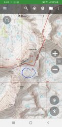
Here-ish. If you are on the UHT, you'll walk right past it up on the tableland before that last approach to the saddle itself. Can't miss it.

If someone else wants to grab coords next time they're there in person, that would be highly appreciated!

Screenshot_20190618-064844_BackCountry Navigator PRO.jpg
 
In 2019 I turn 50 and to commemorate that milestone I'm hiking
the Highline in the Uintas from Leidy to Mirror Lake Highway in 8 days.

I'm looking for some honest, critical comments about my itinerary to
ensure I consider the potential challenges.

Also if you have any thoughts on my selected camp sites, particularly
if any of them are impractical, I'd appreciate it.

My idea was to get 30+ miles in the first 2 days so I could take 0 day, leaving
me about 10 miles a day until the end.

@LarryBoy I've read your Trail Guide many times now. I so desperately want
to do those long ridge walks for the views but I fear I'd be way too slow
doing it that way.

My rough itinerary is as follows:

Friday: Leidy Peak / Hacking Lake --> shelf above Reader Lakes. ~ 15 miles

Saturday: Reader Lakes --> Painter Basin. ~ 17 miles

Sunday: Zero Day. Recover from previous 2 days.

Monday: Painter Basin --> Northstar Lake. ~ 10 miles

Tuesday: Northstar Lake --> Unnamed pond north of Lambert Lake. ~9

Wednesday: Lambert --> Dead Horse Lake. ~ 9 miles

Thursday: Dead Horse --> Brinkley Lake (via Upper Rock Creek trail) ~ 10 miles

Friday: Brinkley --> Hayden Pass Trail Head. ~ 10 miles.
When are you planning to go?
 
Back
Top