Navigation
Install the app
How to install the app on iOS
Follow along with the video below to see how to install our site as a web app on your home screen.
Note: This feature may not be available in some browsers.
More options
Style variation
You are using an out of date browser. It may not display this or other websites correctly.
You should upgrade or use an alternative browser.
You should upgrade or use an alternative browser.
2016-2017 Snowpack
- Thread starter Nick
- Start date
- Joined
- Jun 25, 2012
- Messages
- 4,430
Kullaberg63
Member
- Joined
- Mar 6, 2014
- Messages
- 667
Might wanna take a look at what's going on at Oroville dam (tallest in the US) right now:
http://www.kcra.com
Or look at this earlier vid of the damage to the spillway:
https://weather.com/news/news/oroville-dam-spillway-california-hole-emergency
http://www.kcra.com
Or look at this earlier vid of the damage to the spillway:
https://weather.com/news/news/oroville-dam-spillway-california-hole-emergency
- Joined
- Jun 25, 2012
- Messages
- 4,430
Yeah, I've been following it. Wild! Not clear whether there are any communities threatened down river or not.Might wanna take a look at what's going on at Oroville dam (tallest in the US) right now:
http://www.kcra.com
Or look at this earlier vid of the damage to the spillway:
https://weather.com/news/news/oroville-dam-spillway-california-hole-emergency
Now here in Jackson - big warmup also with quite abit of melting here in town. But still tons of new snow up high. Now while it rained in town, it was all snow up high. The new snow totals up in the Tetons, (at Rendezvous Bowl), are now 433 inches of Total Snow Fall with a snow depth of 144 inches .... that is alot of snow. It is not how much snow is in the valleys that matter. It is the snow up on the mountain tops that matter. And lots of that snow does not melt till May and June with into July. The rivers are going to chuck full of water then at that time all over the west.
- Joined
- May 5, 2012
- Messages
- 1,732
It is not how much snow is in the valleys that matter. It is the snow up on the mountain tops that matter.
Low and mid-elevation snow does matter when it comes to discussion of flood potential. First, because it impacts soil moisture. Saturated soils down low can't absorb snowmelt from up high. Second, because staged release of the snowpack through a warm-cool cycle brings the total volume out over a much longer period.
The monster high-elevation snowpack is still going to be a problem come spring, but if it stays warm down low that could mitigate the risk of property damage.
- Joined
- May 5, 2012
- Messages
- 1,732
It's going to be a big rafting year. BOR just updated their outlook for Flaming Gorge:
Current Status
(Last Updated:February 13, 2017)
Releases are currently 1,800 cfs and expected to increase within the allowable parameters of the ROD up to 2,950 cfs through the end of February. The February water supply forecast of the April through July unregulated inflow volume into Flaming Gorge Reservoir is 1.65 million acre-feet (169 percent of average). Additional storms throughout the basin increased the current projection to 2 maf (~200 percent of average). Current snowpack is 180 percent of median and we have received 117 percent of the season peak for the Upper Green Basin with additional storm systems anticipated through February.
Flaming Gorge will be operated with the utmost caution to address the forecasted runoff. Extended bypass releases will be required to manage the runoff this year. Reclamation is advising all its stakeholders early of the extended bypass releases so that planning for the season may occur.
Base Flow Forecast
The Record of Decision outlines base flow operations based on the observed April-July unregulated inflow volume. The observed April-July unregulated inflow volume into Flaming Gorge Dam was 1.048 million acre-feet. This volume falls in the average (above median) hydrologic classification at 49 percent exceedance for the base flow period. Base flow hydrologic classification may change based on observed hydrology through the end of February 2017.
Unregulated inflow into Flaming Gorge Reservoir during the month of January was 49,000 af, or 122 percent of average. The reservoir elevation is 6,022.9 (82 percent of live capacity) and decreasing.
The February final forecast for inflows for the next three months projects above average conditions: February, March and April forecasted inflow volumes at 50,000 af (112 percent of average), 135,000 af (132 percent of average), and 225,000 af (169 percent of average), respectively.
To view the most current reservoir elevation, content, inflow and release, click on: Flaming Gorge Reservoir Data.
Now thought I would give you an update on the winter and snow conditions here in NW Wyoming. After a record breaking February, the snowpack up high above Teton Village in the Teton's has never been deeper at this point in all of the JH Resort's 40 year history. The settled snow depth at Rendezvous Bowl passed the 150 inches depth mark on February 21st. Also now at the end of February, almost 500 inches of snow has fallen and we haven't even come to the wet spring as of yet. The wettest month here is always May. Right now we are even surpassing the big record year of 1996-97. If this continues like this we one will need snowshoes if one wants to hike in the High Country even in July, and maybe maybe even into August.
As of February, it has been the fourth wettest month ever in the history of Jackson Hole period. And then add to this that last October was the fifth wettest month ever. And also December was so wet and snowy. And now with today, March 1st with even more snow in town and up high ... the snow just keeps on coming and coming. And personally for this coming summer, I don't think that all of the snow we have received and will receive will all melt this coming summer. And that is IF we even have a summer with the way it is going. The local meteorologist Jim Woodmancy had a good article in the local weekly paper today called "February Breaks Record For Snow, Moisture. And at the end says this ... This year I don't expect all that snow at the higher elevations to melt until late July or even August. Or, perhaps sometime after this next Ice Age is over.
Also in the article, Jim Woodmancy says that at the resort, before this year the biggest year was 1996-97, the snow did not reach the 150 inches depth mark until Mid-March. Also some of the local Snotel - Backcountry Snow Monitoring Sites, are recording the current snow pack to be 200% plus or near 200% which is double the amount then normal. Deer Park Snotel Site in the Wind Rivers has now 257% for their snowpack - snow water equivalent as of this morning. This will mean for sure flooding in areas downstream, and sad for the fisherman with muddle waters probably all summer, and to add thousands upon thousands and upon thousands of mosquitoes when it does melt and flood.
Wishing Everyone the Best!
Last edited:
Thanks for posting that Nick, Love It!
Now for those that wonder, here is a listing of the Snotel Sites in Wyoming and what they are currently showing as of this morning. The url is:
www.wrds.uwyo.edu/wrds/nrcs/snowprec/snowprec.html
And just a sampling of some of the sites and what they are showing for the snowpack - snow water equivalent ... some of these are in the Gros Ventres and the Wind River Range knowing how many like to hike in these areas.
Base Camp - Up Pacific Creek near Moran, Wyo. - 179%
Granite Creek - Gros Ventres - 202%
Younts Peak - East of peak below a cliff, Absarokas - 192%
Two Ocean Plateau - Offline
Cold Springs - Wind Rivers - 211%
Deer Park - Wind Rivers - 257%
Hobbs Park - Wind Rivers - 220%
South Pass, Wyo. - 223%
Kirwin, Wyo -SE Absarokas - 226%
Blackwater - Near Fortress Mtn., Absarokas - 174%
Parker Peak - East Yellowstone Park, Head of the Lamar River - 164%
Elkhart Park Guard Station - Wind Rivers - 171%
Gros Ventre Summit - 174%
Kendell Ranger Station - Upper Green River - 213%
New Fork Lake - Wind Rivers - 182%
Triple Peak - Upper Green River - 196%
Blind Bull Summit - Snake River Area - 204%
East Rim Divide - Snake River Area - 214%
Thumb Divide - South YNP - 161%
Togwotee Pass, Wy. - 156%
Spring Creek Divide - Snake River Area - 179%
But less as you go north into Yellowstone Park and the area, but still all above normal.
For what it is worth. Wishing Everyone the Best!
Last edited:
powderglut
In search of Fresh
- Joined
- Oct 17, 2012
- Messages
- 367
@Kmatjhwy You guys are totally killin it this year. I call it..... "in the funnel". The storms can be north or south of you, but... eventually hit the funnel and dump right on you. Jackson has become the daily bullseye. Crazy big numbers.
We were well on our way until the late January/Feb thaw. Still holdin our own in the Yampa/White River Basin at 122% but ....so many days of 40-50 degrees and ridiculous non freezing night time temps have definitely taken a toll on our snow pack. Skiing corn in February just isn't right!!!
It appears the next storm track will cream you guys again and probably stay north of us (Steamboat) for the next 10 days. Who knows what March and April will bring. I have no doubt there is still plenty of winter left. I'll be interested to see where we sit by end of April. And you guys...it might be wise to start building an ark.

- Joined
- Aug 8, 2016
- Messages
- 2,078
http://www.usatoday.com/story/news/...o-deep-scientists-measuring-devices/98623436/
Sent from my iPhone using Tapatalk
Sent from my iPhone using Tapatalk
Now just saw the local forecast at the weather channel posted for the next 10 days. Soooo depressing if one is looking forward to spring and hiking in the High Country. And also looked over at some other sites for here and the nearby country including Yellowstone Park. Also looked at the forecast from the local meteorologist, Jim Woodmancy at his local website 'Mountain Weather' - www.mountainweather.com For here in Jackson it is rain and snow for the next 10 days straight. And up higher, it is all but snow and more snow and then more snow up high on a every freaking day basis. Guess this will mean more snow not only for us but all over here in the Intermountain - Rocky Mountain Area like here, the Wind Rivers, the Uintas, the Wasatch, Etc. Rain down low, and then snow and more and more snow up high which is Already at Record Levels.
Sheesh! As for myself, have begun to put all of my plans on hold. Well, maybe this might be the summer that here, at least up high, there might NOT be much of a summer for hiking and such. It has happened before when there was a year with NOT much of a summer. Think onne year was 1816. Guess we will be able to hike here at some point in the future, and that will be when this freaking present Ice Age is Over!!!
Just posting for whatever it is worth.
DrNed
The mountains are calling and I must go
- Joined
- Mar 31, 2013
- Messages
- 1,026
To those much smarter than I, can you help me interpret the following?
I went to the site
https://www.usbr.gov/uc/water/crsp/cs/fgd.html
to get a forecast for Flaming Gorge releases and how it will affect
floating the Green River this summer. Didn't understand any of
the info in a practical manner.
Also, looking at floating the North Platte in Wyoming. Looked at
NWS site to get some forecast on the flows there. I got these
three graphs:
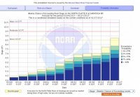
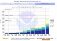
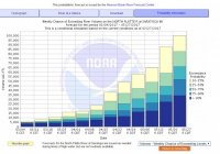
If I'm reading these graphs right they seem to be saying, as of right now high water is likely (through the dates forecasted)
and some chance for flooding, but not the sure thing that I've been lead to believe. Or am I reading these wrong?
Thanks
I went to the site
https://www.usbr.gov/uc/water/crsp/cs/fgd.html
to get a forecast for Flaming Gorge releases and how it will affect
floating the Green River this summer. Didn't understand any of
the info in a practical manner.
Also, looking at floating the North Platte in Wyoming. Looked at
NWS site to get some forecast on the flows there. I got these
three graphs:


If I'm reading these graphs right they seem to be saying, as of right now high water is likely (through the dates forecasted)
and some chance for flooding, but not the sure thing that I've been lead to believe. Or am I reading these wrong?
Thanks
Don't like ads? Become a BCP Supporting Member and kiss them all goodbye. Click here for more info.


