- Joined
- Dec 23, 2013
- Messages
- 4,550
Now where was I before I was so rudely interrupted? Oh yes, day seven of a ten day adventure.
First, here is the link to days 1 trough 6
Days 1 through 6
Day 7 - Campsite on Tributary of the North Fork of the Yellowstone to Campsite on Unnamed Pond below Unnamed Peak 10,962 - 8.46 Miles
Another big day today as we would make our way down to the North Fork of the Yellowstone, then hike up to the pass between Younts Peak and Thorofare Mountain before traversing the bowl above the headwaters of the South Fork of the Yellowstone, dropping down towards Marston Pass, and on to our campsite at an unnamed pond at the foot of unnamed peak 10,962.

Overview map for Day 7

First view of Younts Peak as we make our way down to the North Fork of the Yellowstone

Falls on a side stream to the west of us

Looking back up (north) the drainage of the tributary that flows into the North Fork of the Yellowstone

Younts Peak, and the pass that we will climb up to later in the day

Zoomed in on the pass

Grizzly dig along the North Fork

The beautiful view from the North Fork of the Yellowstone

The North Fork of the Yellowstone

The North Fork of the Yellowstone and Younts Peak

Thorofare Mountain above with some falls running down the west side

Younts Peak

Approaching our climb to the pass

Falls on the North Fork. Those snowfields are the part of the headwaters.

Bob, starting his climb to the pass, looking down the North Fork Drainage

Another angle of Younts. We thought we might catch the tail end of the grizzlies feeding on the cutworm moths as we passed
through, but we were a little to late to see them.

Headwaters basin

Elephant heads near the pass

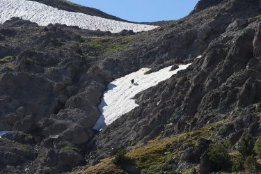
Scott, climbing up to the pass

I have no idea who this is, but she made it to the pass, with an unfocused Younts for proof. Also notice the stink bug on my hand
to keep her company.

Looking down on the headwaters of the South Fork of the Yellowstone and beyond

Younts from the other side

Zoomed in on the Tetons through the hazy skies

A tarn down below as we made our way to the South Fork Trail

Bob on the South Fork Trail

Another tarn

View to the south, with the trail up Marston Pass visible it you squint long enough.")

Better view of the trail

Hillside full of wildflowers, and then around the corner in the trail . . . . . . . . . . . .

Another grizzly!


It took this bear about twenty seconds to run up the mountain and clear the ridge. Just amazing.

Looking over into the Washakie Wilderness

Unnamed Peak 10,962 ahead. We will be skirting around the right hand side of it to get to our campsite for the night.

The unnamed pond we will stay at for the night

Dinner time. I had my second Beef Stroganoff of the trip for dinner
Day 8 - Campsite at Unnamed Pond to Campsite at the headwaters of the South Buffalo Fork - 11.32 miles
The plan for day eight was originally to hike up on top of the Buffalo Plateau, head over to Turner Fork and down the canyon. The problem was that we, or better yet I, had no idea where to pick up the trail up top on the plateau. And since Turner Fork is a rugged canyon, to not find the trail right off could be perilous. So we changed plans and went south across the plateau two more canyons and descended into what we named Bob's Canyon, for this was Bob's intended route for the day. Everything that needed a name once in the canyon was named after @Bob Like Bob's Trail, Bob's Waterfall, well, you get the idea.

100K map overview for day 8
Broken up into 24K parts - A and B


Climbing up on to the Buffalo Plateau

Drop down into Lost Creek Drainage across the way

Originally driving to this pond to drop down into Turner Fork

Look the Turner Fork Drainage

A lot of up and down heading to Bob's Canyon

More ponds up top

Another hill to climb

Looking back (north) at Younts Peak

Bob, making his way across the plateau

Not sure why, but I like this picture

The pond we have been searching for to drop down into Bob's Canyon

Looking down into Bob's Canyon

Reaching the stream in upper Bob's Canyon. We will be heading downstream from here.


The beginnings of the trail down the canyon

Looking back up canyon

Heading towards the South Buffalo Fork

Bob's Trail

Bob's Falls

Bob's Fork


Looking up to the top of the plateau

Leaving the canyon and about to reach the South Buffalo Fork

Crossing the South Buffalo Fork

Looking back down the South Buffalo Fork

Our pitched tents at the headwaters of the South Buffalo Fork

Eating dinner


My dinner for night eight

And a circus peanut for good measure

A visitor at camp
Day 9 - Campsite at the Headwaters of South Buffalo Fork to Campsite on Cub Creek - 9.38 miles
In the early morning hours I got that feeling that I'm sure most backpackers dread. I had to use the bathroom and I had to use it now. Normally, I don't use my headlamp when I have to go in the night, but I needed to go ways to find a proper location. I'm pretty sure I woke Bob or Dave, maybe even both as I fast walked past their tents. Usually Scatman doesn't move that fast. After doing my business I returned to my tent for a restless rest of the night.
When I awoke in the morning, I just plain didn't feel well, as I made my way over to the group to eat breakfast. Two packets of oatmeal in my standard backcountry breakfast, but today I only had one, not sure if I could keep it down, or that it might possibly just pass straight through me.
Bob was ahead of the rest of us, as we had one more night in the backcountry, Bob was headed all the way out a day early, which meant he had a big mileage day ahead of him. We said our goodbyes as I headed back to the trees once again.
Dave and were way ahead of me in the packing department too, and they headed up the trail saying that they would meet me at the top of the hill. I positioned my shovel (like I would have time to dig a hole) and toilet paper in my backpack so that I could get to it quickly if need be. I then proceeded to make my way up the hill that separated the South Buffalo Fork drainage from the Cub Creek drainage. It sure felt like it took me a long time to top that hill.
Once at the top, we had to find the trail down Cub Creek, as it wasn't obvious to us. After hooking up with the trail we made our way down Cub Creek. I wasn't eating or drinking much thinking that whatever I put into my stomach wasn't going to stay long, so the nine mile day turned out to be a long one for me. As a matter of fact, this day turned out to be the hardest for me.
At some point those who designed the Cub Creek Trail decided that they would make the trail start to climb up to the top of the ridge instead of just following the creek. Brilliant! Just at the point where the trail leaves the creek and starts ascending, there was an intersection. Now I was way behind @wsp_scott and @TractorDoc at this point and earlier they had talked about a cutoff trail somewhere along our route today. I was only half paying attention, as I was concentrating on not having to go to the bathroom and just simply moving my feet. So I let out a barbaric yawl to see if they would respond. No response. I then made a command decision to take the ascending trail. Every now and then I would yell "Yo!" at the top of my lungs, but still no response. I hadn't run into any boot prints on this upper trail, so I turned around and headed back to the intersection and took the path less travelled. Maybe twenty feet along the trail I ran into a boot print and felt better about my decision to turn around. But it soon became apparent that this trail was in bad shape. Even though it had sewn logs along it, I felt that this was probably the old trail and that the Forest Service must have moved it uphill into the forest at some point. I gave out one last "Yo!", and was semi shocked when I got a reply. Dave answered and said that they were on the upper trail, which meant turning back around for me and retracing my footsteps again. I think it might have been possible that I did 10.5 miles this day.
Once I hooked back up with Scott and Dave, we continued to climb until we reached essentially the top of the ridge. The day was clear, sunny and hot and I was losing energy. We eventually reached an unofficial cutoff trail (elk trail maybe?) that looked like it would cutoff some distance between the Cub Creek Trail and the Brooks Lake Trail. At first this seemed like a good choice, but eventually we ran into a downfall mess.
We eventually made it to the trail we wanted, took it back down to Cub Creek, crossed the creek and set up camp in a small meadow with some CDT hikers to keep us company.

Day 9 overview map

Looking back down on the headwaters of the South Buffalo Fork where we had camped last night

Junction sign at the top of the hill

View down the Cub Creek Drainage. Now we just have to find the trail.

On trail.

Cub Creek

I call this Fireweed Shadow.

Mountain dandelion

View down Cub Creek

This is the old trail that I thought might be the discussed cutoff trail

Looking back up Cub Creek, and as you can see we are gaining elevation

View up the Cub Creek Drainage

Not the best shot, but some FS trail crew workers passed me on the trail heading back down to Cub Creek. On is carrying a
crosscut saw or misery whip

Looking down on Cub Creek and our eventual campsite

Time for dinner

My dinner.
Day 10 - Campsite on Cub Creek to the Brooks Lake Trailhead - 5.41 miles
Day ten would be the shortest day of our trip. I had eaten dinner the previous night and gotten a good night's sleep without having any emergencies, and I woke up feeling better than I had the day before. I wasn't quite 100%, but I felt I had some energy that I hadn't had the previous day. Of course, we had to start out our last day by climbing again. This time making our way up from the Cub Creek Drainage and dropping down into the Brooks Lake Creek Drainage.
Our eight days without rain came to an abrupt end during the night as it poured. Fortunately for us, it let up before we got up. It did leave everything wet though and made for a muddy climb up to the pass.

Day 10 overview map

The trail crew once again. The camped just to the west of us in an adjacent meadow

We were now on the CDT route as we made our way to Brooks Lake

Sign high in a tree along the trail

Muddy conditions heading up thanks to the overnight rain

Crossing out of the wilderness

Upper Brooks Lake

View to the west from Upper Brooks Lake

The meadows that Brooks Lake Creek flows through. Our trailhead is at the south end of the meadow.

Mules on day one, and mules on day ten. In other words bookended by mules. Now that is hard to beat.


Crossing Brooks Lake Creek

Some real cowboys and cowgirls

Trail sign in the middle of the meadow

Looking back north

My dream house.

Brooks Lake

View to the west of the lake

The trailhead gate

Back at the Sube in one piece. I think.

Settling in at Signal Mountain Lodge for . . . . . . . . .

Wait, who is this?

Celebratory Nachos! And fries? And salad?

And I couldn't resist taking a picture of this on our way out. Scatman Yoga! Coming to a forest near you soon.
Well, that about wraps it up.
I'd like to thank Bob, Dave, and Scott for joining me on one last trip to the Thorofare. I hope they had as much enjoyment out of it as I did.
The End.
First, here is the link to days 1 trough 6
Days 1 through 6
Day 7 - Campsite on Tributary of the North Fork of the Yellowstone to Campsite on Unnamed Pond below Unnamed Peak 10,962 - 8.46 Miles
Another big day today as we would make our way down to the North Fork of the Yellowstone, then hike up to the pass between Younts Peak and Thorofare Mountain before traversing the bowl above the headwaters of the South Fork of the Yellowstone, dropping down towards Marston Pass, and on to our campsite at an unnamed pond at the foot of unnamed peak 10,962.
Overview map for Day 7
First view of Younts Peak as we make our way down to the North Fork of the Yellowstone
Falls on a side stream to the west of us
Looking back up (north) the drainage of the tributary that flows into the North Fork of the Yellowstone
Younts Peak, and the pass that we will climb up to later in the day
Zoomed in on the pass
Grizzly dig along the North Fork
The beautiful view from the North Fork of the Yellowstone
The North Fork of the Yellowstone
The North Fork of the Yellowstone and Younts Peak
Thorofare Mountain above with some falls running down the west side
Younts Peak
Approaching our climb to the pass
Falls on the North Fork. Those snowfields are the part of the headwaters.
Bob, starting his climb to the pass, looking down the North Fork Drainage
Another angle of Younts. We thought we might catch the tail end of the grizzlies feeding on the cutworm moths as we passed
through, but we were a little to late to see them.
Headwaters basin
Elephant heads near the pass
Scott, climbing up to the pass
I have no idea who this is, but she made it to the pass, with an unfocused Younts for proof. Also notice the stink bug on my hand
to keep her company.
Looking down on the headwaters of the South Fork of the Yellowstone and beyond
Younts from the other side
Zoomed in on the Tetons through the hazy skies
A tarn down below as we made our way to the South Fork Trail
Bob on the South Fork Trail
Another tarn
View to the south, with the trail up Marston Pass visible it you squint long enough.
Better view of the trail
Hillside full of wildflowers, and then around the corner in the trail . . . . . . . . . . . .
Another grizzly!
It took this bear about twenty seconds to run up the mountain and clear the ridge. Just amazing.
Looking over into the Washakie Wilderness
Unnamed Peak 10,962 ahead. We will be skirting around the right hand side of it to get to our campsite for the night.
The unnamed pond we will stay at for the night
Dinner time. I had my second Beef Stroganoff of the trip for dinner
Day 8 - Campsite at Unnamed Pond to Campsite at the headwaters of the South Buffalo Fork - 11.32 miles
The plan for day eight was originally to hike up on top of the Buffalo Plateau, head over to Turner Fork and down the canyon. The problem was that we, or better yet I, had no idea where to pick up the trail up top on the plateau. And since Turner Fork is a rugged canyon, to not find the trail right off could be perilous. So we changed plans and went south across the plateau two more canyons and descended into what we named Bob's Canyon, for this was Bob's intended route for the day. Everything that needed a name once in the canyon was named after @Bob
Like Bob's Trail, Bob's Waterfall, well, you get the idea.100K map overview for day 8
Broken up into 24K parts - A and B
Climbing up on to the Buffalo Plateau
Drop down into Lost Creek Drainage across the way
Originally driving to this pond to drop down into Turner Fork
Look the Turner Fork Drainage
A lot of up and down heading to Bob's Canyon
More ponds up top
Another hill to climb
Looking back (north) at Younts Peak
Bob, making his way across the plateau
Not sure why, but I like this picture
The pond we have been searching for to drop down into Bob's Canyon
Looking down into Bob's Canyon
Reaching the stream in upper Bob's Canyon. We will be heading downstream from here.
The beginnings of the trail down the canyon
Looking back up canyon
Heading towards the South Buffalo Fork
Bob's Trail
Bob's Falls
Bob's Fork
Looking up to the top of the plateau
Leaving the canyon and about to reach the South Buffalo Fork
Crossing the South Buffalo Fork
Looking back down the South Buffalo Fork
Our pitched tents at the headwaters of the South Buffalo Fork
Eating dinner
My dinner for night eight
And a circus peanut for good measure
A visitor at camp
Day 9 - Campsite at the Headwaters of South Buffalo Fork to Campsite on Cub Creek - 9.38 miles
In the early morning hours I got that feeling that I'm sure most backpackers dread. I had to use the bathroom and I had to use it now. Normally, I don't use my headlamp when I have to go in the night, but I needed to go ways to find a proper location. I'm pretty sure I woke Bob or Dave, maybe even both as I fast walked past their tents. Usually Scatman doesn't move that fast.
After doing my business I returned to my tent for a restless rest of the night.When I awoke in the morning, I just plain didn't feel well, as I made my way over to the group to eat breakfast. Two packets of oatmeal in my standard backcountry breakfast, but today I only had one, not sure if I could keep it down, or that it might possibly just pass straight through me.
Bob was ahead of the rest of us, as we had one more night in the backcountry, Bob was headed all the way out a day early, which meant he had a big mileage day ahead of him. We said our goodbyes as I headed back to the trees once again.
Dave and were way ahead of me in the packing department too, and they headed up the trail saying that they would meet me at the top of the hill. I positioned my shovel (like I would have time to dig a hole) and toilet paper in my backpack so that I could get to it quickly if need be. I then proceeded to make my way up the hill that separated the South Buffalo Fork drainage from the Cub Creek drainage. It sure felt like it took me a long time to top that hill.
Once at the top, we had to find the trail down Cub Creek, as it wasn't obvious to us. After hooking up with the trail we made our way down Cub Creek. I wasn't eating or drinking much thinking that whatever I put into my stomach wasn't going to stay long, so the nine mile day turned out to be a long one for me. As a matter of fact, this day turned out to be the hardest for me.
At some point those who designed the Cub Creek Trail decided that they would make the trail start to climb up to the top of the ridge instead of just following the creek. Brilliant! Just at the point where the trail leaves the creek and starts ascending, there was an intersection. Now I was way behind @wsp_scott and @TractorDoc at this point and earlier they had talked about a cutoff trail somewhere along our route today. I was only half paying attention, as I was concentrating on not having to go to the bathroom and just simply moving my feet. So I let out a barbaric yawl to see if they would respond. No response. I then made a command decision to take the ascending trail. Every now and then I would yell "Yo!" at the top of my lungs, but still no response. I hadn't run into any boot prints on this upper trail, so I turned around and headed back to the intersection and took the path less travelled. Maybe twenty feet along the trail I ran into a boot print and felt better about my decision to turn around. But it soon became apparent that this trail was in bad shape. Even though it had sewn logs along it, I felt that this was probably the old trail and that the Forest Service must have moved it uphill into the forest at some point. I gave out one last "Yo!", and was semi shocked when I got a reply. Dave answered and said that they were on the upper trail, which meant turning back around for me and retracing my footsteps again. I think it might have been possible that I did 10.5 miles this day.
Once I hooked back up with Scott and Dave, we continued to climb until we reached essentially the top of the ridge. The day was clear, sunny and hot and I was losing energy. We eventually reached an unofficial cutoff trail (elk trail maybe?) that looked like it would cutoff some distance between the Cub Creek Trail and the Brooks Lake Trail. At first this seemed like a good choice, but eventually we ran into a downfall mess.
We eventually made it to the trail we wanted, took it back down to Cub Creek, crossed the creek and set up camp in a small meadow with some CDT hikers to keep us company.
Day 9 overview map
Looking back down on the headwaters of the South Buffalo Fork where we had camped last night
Junction sign at the top of the hill
View down the Cub Creek Drainage. Now we just have to find the trail.
On trail.
Cub Creek
I call this Fireweed Shadow.
Mountain dandelion
View down Cub Creek
This is the old trail that I thought might be the discussed cutoff trail
Looking back up Cub Creek, and as you can see we are gaining elevation
View up the Cub Creek Drainage
Not the best shot, but some FS trail crew workers passed me on the trail heading back down to Cub Creek. On is carrying a
crosscut saw or misery whip
Looking down on Cub Creek and our eventual campsite
Time for dinner
My dinner.
Day 10 - Campsite on Cub Creek to the Brooks Lake Trailhead - 5.41 miles
Day ten would be the shortest day of our trip. I had eaten dinner the previous night and gotten a good night's sleep without having any emergencies, and I woke up feeling better than I had the day before. I wasn't quite 100%, but I felt I had some energy that I hadn't had the previous day. Of course, we had to start out our last day by climbing again. This time making our way up from the Cub Creek Drainage and dropping down into the Brooks Lake Creek Drainage.
Our eight days without rain came to an abrupt end during the night as it poured. Fortunately for us, it let up before we got up. It did leave everything wet though and made for a muddy climb up to the pass.
Day 10 overview map
The trail crew once again. The camped just to the west of us in an adjacent meadow
We were now on the CDT route as we made our way to Brooks Lake
Sign high in a tree along the trail
Muddy conditions heading up thanks to the overnight rain
Crossing out of the wilderness
Upper Brooks Lake
View to the west from Upper Brooks Lake
The meadows that Brooks Lake Creek flows through. Our trailhead is at the south end of the meadow.
Mules on day one, and mules on day ten. In other words bookended by mules. Now that is hard to beat.
Crossing Brooks Lake Creek
Some real cowboys and cowgirls
Trail sign in the middle of the meadow
Looking back north
My dream house.
Brooks Lake
View to the west of the lake
The trailhead gate
Back at the Sube in one piece. I think.
Settling in at Signal Mountain Lodge for . . . . . . . . .
Wait, who is this?
Celebratory Nachos! And fries? And salad?
And I couldn't resist taking a picture of this on our way out. Scatman Yoga! Coming to a forest near you soon.
Well, that about wraps it up.
I'd like to thank Bob, Dave, and Scott for joining me on one last trip to the Thorofare. I hope they had as much enjoyment out of it as I did.
The End.