Yellowstone Question

Stevebo

Member
Joined
Feb 15, 2017
Messages
5
Paging Joey or Scatman. You were referred by people on the Backpacker.com Forums

I'm looking at the Trails Illustrated Old Faithful section map and the Boundary Trail seems to just end at TH 9K8 (Boundary Creek).

Does anyone know if the trail continues through the Caribou-Targhee NF up to the CDT / Summit Lake TH (9K9)? It appears to be about 5-6 miles North of there.
Thanks,
Steve

In the meantime, did you look at the same area at CalTopo.com?
I've found that Trails Illustrated maps lack detail that is shown on USGS quadrangles.
Good luck.
Wayne


Sent from my iPhone using Tapatalk
 
To continue with Venchka's advice, looking at Forest Service maps, and Google Earth, you can see that the trail continues west to Forest Service Road 82, which travels in a roundabout way north-south, eventually leading to other logging roads, skids roads, and eventually to the CDT. That is one option.

Another option is to head north from Buffalo Lake, either staying on the plateau west of Boundary Creek or dropping down into the valley bottom, and heading north (up) the Boundary Creek drainage. This keeps you in the park.

Once you reach the plateau that the Summit Lake (CDT) trail runs along, you have a couple of choices. Either follow the base of the plateau northwest until you cross the CDT or you can hike up onto the plateau and continue north or NNE, which will lead you to the CDT within a couple miles. The plateaus in that country are easy traveling, the forest is, for the most part, relatively open. The section of the CDT that I have been on (east of Summit Lake) is easy to spot if you are coming onto it from a north or south direction. This route requires good orienteering skills.

The topos you are looking for are the Buffalo Lake and Buffalo Lake NE (1:24,000). For what it's worth, my preferred website is https://ngmdb.usgs.gov/maps/TopoView/viewer/#12/44.3758/-111.0641
Click on the Topo map icon in the upper left corner, and the 1:24000 Map Scales option along the right side and you'll be good.

You can also go on the Caribou-Targhee NF website and find the Ashland-Island Park Ranger District Park Summer Recreation Opportunities map that shows the FS roads and trails in that area.
 
Last edited:
I just did and the trail appears to end right at the park boundary.
Yes. I'm there now. Outdoor_Fool nailed it. Bushwhack about 5-6 mile north.
@Joey doesn't always use trails either. I'm currently trying to figure out a trip of his in Grand Teton N.P. It looks to spooky for my old tired bones.
Good luck! Let us know if you figure out how to connect the dots. That would be a really nice loop from Old Faithful.
Wayne
PS:
It looks like you can go up Boundary Creek to the intersection with Cascade Creek coming in from the northeast. Follow Cascade Creek upstream, a zig left and a zag right and continue northeast until the creek runs across the Summit Lake Trail.
There it is. Old Faithful-Shoshone Lake-Shoshone Geyser Basin-Bechler River-Summit Lake-Old Faithful Loop. Very interesting.
 
Old Faithful-Shoshone Lake-Shoshone Geyser Basin-Bechler River-Summit Lake-Old Faithful Loop.

Yes, that's what I was thinking. It still might be easier to head into the National Forest and take a dirt road most of the way. Not sure.
 
Yes, that's what I was thinking. It still might be easier to head into the National Forest and take a dirt road most of the way. Not sure.
The maze of roads looks like you could end up at Mack's Inn or the http://frostopdrivein.com in Ashton. There are worse ways to end a hike.


Sent from my iPhone using Tapatalk
 
Last edited:
Paging Joey or Scatman. You were referred by people on the Backpacker.com Forums

I'm looking at the Trails Illustrated Old Faithful section map and the Boundary Trail seems to just end at TH 9K8 (Boundary Creek).

Does anyone know if the trail continues through the Caribou-Targhee NF up to the CDT / Summit Lake TH (9K9)? It appears to be about 5-6 miles North of there.
Thanks,
Steve
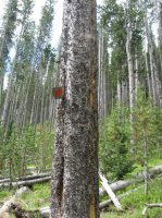
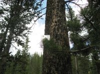
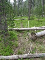
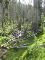
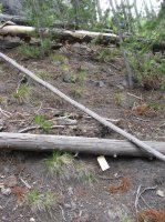
Ah, the old now defunct West Boundary Trail. Yes, there is (was) a trail that runs from trailhead 9K8 north to trailhead 9K9. It was used at one time to patrol for poachers along the western boundary of the Park. From trailhead 9K8 it goes north along the Park boundary up until about .7 miles south of where the Summit Lake Trail reaches the Park boundary. At this point it crosses Forest Service land though never more than a tenth of mile from the boundary where it then reenters the Park at trailhead 9K9. The trail is no longer maintained and after the fires of '88, my guess is that there are a lot of sticks down and some new growth to contend with. I've hiked a couple portions of the West Boundary Trail and while there were some trail markers along the way, there was no discernible trail to speak of except in fairly small stretches (maybe 30 yards at most and only in a couple of places).

WB_01.jpg
Trailmarker of the defunct West Boundary Trail

WB_02.jpg
One of the few on a standing tree

WB_03.jpg
One completely whited out due to age?

WB_04.jpg
One of only two spots where the trail could be seen on the ground

WB_05.jpg
West Boundary Trail goes straight trough this.
 
Last edited:
Yes, that's what I was thinking. It still might be easier to head into the National Forest and take a dirt road most of the way. Not sure.

If you want to do the loop, just head up Boundary Creek from Buffalo Lake, take a right into the Cascade Creek drainage and follow the drainage all the way to the Summit Lake Trail. While you will be stepping over some downfall along the way it should be easier and more straight forward than finding (hopefully) the old trail and following it. Hope this helps.
 
just head up Boundary Creek from Buffalo Lake, take a right into the Cascade Creek drainage and follow the drainage all the way to the Summit Lake Trail.

That sounds like a great idea. The drainage will keep me from getting lost and the blowdowns in some of those pictures on the Western Boundary Trail -- wow. Many thanks!

I hope the backcountry office will permit consecutive nights at 9A5 and 0E1
 
Yes. I'm there now. Outdoor_Fool nailed it. Bushwhack about 5-6 mile north.
@Joey doesn't always use trails either. I'm currently trying to figure out a trip of his in Grand Teton N.P. It looks to spooky for my old tired bones.

Which trip? I've done a couple of his off trail trips with him. Not to mention 20 other trips in that park.
 
I hope the backcountry office will permit consecutive nights at 9A5 and 0E1

I don't think you will have any problem reserving those two sites for two consecutive nights each. Are you mailing in a request for a permit or are you just going to walk-in and get one?
 
If you want to do the loop, just head up Boundary Creek from Buffalo Lake, take a right into the Cascade Creek drainage and follow the drainage all the way to the Summit Lake Trail. While you will be stepping over some downfall along the way it should be easier and more straight forward than finding (hopefully) the old trail and following it. Hope this helps.
scatman,
Thanks for the confirmation. Do you have a rough idea how long it might take a couple of Geezers to complete that loop? Say averaging 10 mpd?
Thanks for your help.
Wayne


Sent from my iPhone using Tapatalk
 
scatman,
Thanks for the confirmation. Do you have a rough idea how long it might take a couple of Geezers to complete that loop? Say averaging 10 mpd?
Thanks for your help.
Wayne
Sent from my iPhone using Tapatalk

@Venchka - It looks like your loop is roughly 74 miles give or take in length, so eight days if you're going an average 10 miles per day. Of course, you'll have to stay at designated backcountry sites which may not fall nicely into 10 mile days. What campsites along the way would you like to stay at? The day from campsite 9A5 on Buffalo Lake to 0E1 at Summit Lake is approximately a 13 mile day with probably more than half off-trail; so you'll want to take that into account. After Summit Lake, are you planning on staying at Old Faithful for one night? If not, it will be quite a haul to 0A1 (14-15 miles). Of course, if you can handle the longer miles, then distance between campsites is moot.

I'm attaching a KMZ file of what I think your route is.
 

Attachments

  • Buffalo_Lake_Summit_Lake_Bechler_River_Loop.kmz
    38.6 KB · Views: 11
Thanks scatman!
It looks like I should rethink this. Or hit the gym real hard and replace some of my old, heavy gear.
Wayne
 
Thanks scatman!
It looks like I should rethink this. Or hit the gym real hard and replace some of my old, heavy gear.
Wayne

@Venchka - I didn't mean to discourage you with my reply. Silly me, or perhaps stupid me, when I thought about the loop, I assumed you would start at the Bechler River Ranger Station down in the southwestern corner of the Park. If you started instead at Old Faithful (Howard Eaton Trailhead), you would avoid that long day from Summit Lake to campsite 0A1 near the Firehole River. This also would cut off 11 miles in trip length due to a cutoff trail , so you would be looking at roughly 63 miles and would knock a couple days off of your trip. You would also be able to make your 10 mile a day requirement except for the day between Buffalo Lake and Summit Lake. At that point, you would only have two days worth of food on your back and once you get up onto the Madison Plateau it should be easy walking. What do you think?

New route and campsites attached.
 

Attachments

  • Buffalo_Lake_Summit_Lake_Bechler_River_Loop_Option_2.kmz
    35.6 KB · Views: 8
  • Buffalo_Lake_Summit_Lake_Bechler_River_Loop_Option_2_Campsites.kmz
    2.2 KB · Views: 19
Thank you! Thanks. [emoji1][emoji106]
Probably better still, There will be Two Geezers and 2 cars. One for the Lone Star trailhead, or whatever it's called east of Old Faithful, and the other at Biscuit Basin. Much better I think.
A good way to see a backcountry Geyser Basin and the Bechler river without retracing any trail.
All we need know is Mrs. Wayne's permission.
One of my best thread jackings.


Sent from my iPhone using Tapatalk
 
I'd plan 7 map miles.......it will always be more like 9ish. You can always ask for off site camping site....they approve some
 
Thanks Bob. We will definitely approach this trip with a conservative itinerary.
Wayne


Sent from my iPhone using Tapatalk
 
Similar threads
Thread starter Title Forum Replies Date
IlVagabondo Yellowstone Camping Question General Discussion 13
P Question about fording rivers in Yellowstone Trip Planning 10
P Question about going around Shoshone Lake in Yellowstone Trip Planning 0
isaac Yellowstone NP Campsite Reccs Trip Planning 2
Bob Island Park / Yellowstone Private Airport Development General Discussion 8
TheMountainRabbit News Release: Yellowstone National Park increases protection for bears and visitor safety by implementing changes to two bear management areas General Discussion 14
TractorDoc Yellowstone's Gallatin River -- September 7-9th 2023 Backpacking 12
wsp_scott Yellowstone Lake to Brooks Lake (Aug 2023) Backpacking 16
TractorDoc Yellowstone's Thorofare and the Teton Wilderness 08/09/2023 - 08/18/2023 Part Nine / Day Nine + Ten! Backpacking 20
TractorDoc Yellowstone's Thorofare and the Teton Wilderness 08/09/2023 - 08/18/2023 Part Eight / Day Eight Backpacking 14
TractorDoc Yellowstone's Thorofare and the Teton Wilderness 08/09/2023 - 08/18/2023 Part Seven / Day Seven Backpacking 13
TractorDoc Yellowstone's Thorofare and the Teton Wilderness 08/09/2023 - 08/18/2023 Part Six / Day Six Backpacking 28
TractorDoc Yellowstone's Thorofare and the Teton Wilderness 08/09/2023 - 08/18/2023 Part Five / Day Five Backpacking 16
LarryBoy Select Peaks of the Greater Yellowstone - Second Edition (coupon code for pre-order) General Discussion 12
TractorDoc Yellowstone's Thorofare and the Teton Wilderness 08/09/2023 - 08/18/2023 Part Four / Day Four Backpacking 15
scatman The Gallatin River, Bighorn and Fawn Passes, Yellowstone National Park - September 7, 2023 Backpacking 14
TractorDoc Yellowstone's Thorofare and the Teton Wilderness 08/09/2023 - 08/18/2023 Part Three / Day Three Backpacking 10
TractorDoc Yellowstone's Thorofare and the Teton Wilderness 08/09/2023 - 08/18/2023 -- Part Two / Day Two Backpacking 6
TractorDoc Yellowstone's Thorofare and the Teton Wilderness 08/09/2023 - 08/18/2023 --Part One / Day One Backpacking 10
scatman Yellowstone's Thorofare, Headwaters of Thorofare Creek, Majo Pass, Younts Peak, Bob's Canyon, and Cub Creek - August 9, 2023 - Days 7 through 10 Backpacking 34
scatman Yellowstone's Thorofare, Headwaters of Thorofare Creek, Majo Pass, Younts Peak, Bob's Canyon, and Cub Creek - August 9, 2023 - Days 1 through 6 Backpacking 56
F Hat Recovered-Yellowstone Backcountry General Discussion 0
J South Crandall Creek and the Hoodoos Wyoming and Yellowstone? Trip Planning 3
RockyMntCol Trip Planning Younts Peak / South Fork Yellowstone Trip Planning 12
F Shakedown - Yellowstone Thorofare Trip Planning 13
Rockskipper @Bob or anyone know why they closed down part of the forest near W. Yellowstone? General Discussion 6
I Rescue Creek - Yellowstone National Park - June 3, 2023 Backpacking 15
Bob Bear charge - Yellowstone General Discussion 1
scatman Rescue Creek - Yellowstone National Park - June 3, 2023 Backpacking 56
I Slough Creek - Yellowstone June 5 & 6 Meet Up (Members Only) 19
Bob Yellowstone 5/8/23 - UPDATE General Discussion 9
Parashakti Late July in Yellowstone Trip Planning 9
scatman Rescue Creek - Yellowstone National Park Meet Up (Members Only) 19
E Weeklong+ backpacking recs in Yellowstone NP? Trip Planning 11
Jackson Yellowstone Backcountry Lottery Results General Discussion 45
BobFink Yellowstone South Entrance to Fox Creek via Basin Creek Cutoff - Labor Day 2022 Trip Reports 4
Bob Snakes in Yellowstone General Discussion 11
shredhiker Yellowstone Heart Lake September 2022 Backpacking 9
Janice Yellowstone Yurt Camp - Feb. 19-23, 2023 Trip Reports 15
TheMountainRabbit Northern Yellowstone NP - January 2023 Winter Sports 6
Ymyr Suggestions in a Yellowstone and a Beartooth trip Trip Planning 29
scatman A Yellowstone Love Story (Bog Creek Euphoria) - September 12, 2022 Backpacking 28
TractorDoc Yellowstone's Wrangler Lake, Bog Creek, Joseph's Coat Springs, Broad Creek, Wapiti Lake, Hot Springs Basin, and Pelican Valley. The Second Half. Backpacking 15
Georgia Yankee Where to see/hear wolves Yellowstone NP backcountry in September? Trip Planning 16
TractorDoc Yellowstone's Wrangler Lake, Bog Creek, Joseph's Coat Springs, Broad Creek, Wapiti Lake, Hot Springs Basin, and Pelican Valley. Part One of Two. Backpacking 61
TractorDoc Yellowstone's Hayden Valley, Trout Creek, Beach Lake, and Arnica Creek Meadows. September 11, 2022. Hiking & Camping 7
TheMountainRabbit Pitchstone/Bechler Loop (Yellowstone NP) - September 2022 Backpacking 17
P Summer night in Yellowstone Backpacking 4
P Yellowstone, one night by a lake Backpacking 19
wsp_scott Yellowstone September 2021 Backpacking 6

Similar threads

Back
Top