fossana
Member
- Joined
- Jan 11, 2018
- Messages
- 1,035

Intro
Despite the plethora of beautiful backcountry in my backyard, I was getting bored of the same terrain and starting looking for somewhere new to visit. I originally considering doing a short backpacking trip on the N Rim, but the wind forecast looked nasty starting Sunday due to an incoming winter snowstorm. Since it was a day trip, I limited my search to a 2.5h drive time (one-way). I also wanted to keep the elevation below 6500' since there was still quite a bit of snow on Canaan Mt Wilderness the weekend prior.
Luckily I came across Jamal's video on the Paria area. Using his trip report for inspiration, I sketched out an approximate route from Yellow Rock, across the ridge to a point W of Sam Pollock arch, then down to the arch and out the adjacent drainage to Hackberry Canyon, and finally downstream in Hackberry Canyon to the trailhead. I included an option for continuing on to Stone Donkey Canyon, but later abandoned this idea when I realized a pre-dawn start with temps in the low 20s was not so appealing.
Approximate Route
Start/end: Lower Hackberry Canyon TH
Mileage/Elevation Gain: ~13 with 2400' of gain

Trip Report
I arrived at the Lower Hackberry Canyon trailhead ~8:30am; it was in the low 20s. Cottonwood and Hackberry Creeks were almost completely iced over, so I was happy about my plan to do the loop counter-clockwise. There were a few cars when I started out, but surprisingly I had the entire Yellow Rock ascent to myself.


According to the topo, there were several ways to descend Yellow Rock in a northish direction. I took the NE option, the traversed back to true N. In retrospect, NW would have been better because after a short distance, I encountered an unexpected lightly used horse/hiker trail heading almost exactly along the rough route I had drawn in advance. I hadn't seen this trail referenced anywhere.


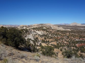
I was pleasantly surprised by the interesting terrain and breathtaking views, with Hackberry Canyon and the Cockscomb to the east and Paria River Basin to the west.


After a few hours of sandy ridge walking, it was time to leave the horse trail and find my way down to Sam Pollock Arch. I tried to stick to drainages and deer/cow trails where possible to avoid stepping on cryptobiotic soil. I finally hit the drainage adjacent to the arch and just S of where it was labeled on the map. I saw only a single set of footprints. I wasn't entirely certain where the arch was relative to the label, but it turned out to be right next to the drainage. After a few photos, I headed downcanyon and again was impressed by the beautiful topography.


The relatively easy path ended at a tall pour-off, but an exposed path provided a bypass. Soon, I was near the end of the drainage and in lower Hackberry Canyon. Hackberry Canyon is quite wide in this section with ghostly at this time of year cottonwoods. The historic Watson Cabin appeared to have been recently restored. I heard the brush rustling, and came across a small herd of cows. While I like cows (I grew up on a small farm), it pains me to see them in a wilderness area where water is so scarce.


In the final ~1.25 miles from the trailhead, the canyon narrows. There were thick patches of ice that I hoped would not cave in as I cross them. Fortunately, any required water crossings were shallow and brief. I ran into the only people I saw on route, a party of two backpackers from Flagstaff heading upstream. Hopefully they had at least 15F sleeping bags.


Soon, I was back at the trailhead in time to try the new-to-me Cuban restaurant in Kanab. I'm looking forward to heading back to this area for a longer trip.
")

