Wind Rivers Highline trail??

Dr. Nick

Member
Joined
Feb 17, 2018
Messages
14
My brother, my son, and I want to do the highline trail in the wind rivers. Whenever I try to get information about it, I always get the High Route info. While the
High Route sounds amazing and unreal, I cannot physically do it due to my age and bad knee and back surgery, etc. We would take 7 days doing it so that we could flyfish along the way.
Different sources show the CDT separate from the Highline trail in spots and they merge in one place.
Has anyone done either of these trails? We would start at big Sandy lake trailhead and end up at the Green River lakes parking lot. I read somewhere the highline trail hasn't been cleared of downfalls after the wind event from a few years ago.
 
Which one..... Everyone calls theirs the high line trail. There are many. Here is the one I did in 2009, before most anyone else. The Red is our actual route, The Yellow route on the north end is what we planned, but got stormed out at Camp 6. A slide showes follows the map. We were not interested in long ridge walking, more in staying close to the peaks, fishing and scenery. We did not stay on the CDT stuff till the end. There are variations that use the CDT and lower trail system. The CDT and lower highline portion is cleared....it is a major destination. Some of the side trails are not. 7 days is quick..... as it is pushed 90 to 100 miles one end to the other. PM me for more info specifics.

Also search the forum for the Wind Rivers for info.

Click here to view on CalTopo
 
@Bob is right - lot's of "Highline" trails. His route is epic. The official (?) Caltopo labeled "Highline" would be easier if that's what you're seeking. Still, 7 days is moving fast, especially if you want to fish. But, I'm slow setting up camp and my fishing gear. Like Bob said- wouldn't worry about downfall along that trail. CDT variations exist especially for the Cirque and Titcomb. The "official" Highline does not go through either.
 
  • Like
Reactions: Bob
Great video - in addition to the photos, I like the transitions.
 
  • Like
Reactions: Bob
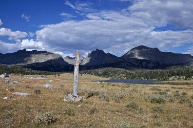
@Dr. Nick the Highline Trail USFS #094 runs up the western edge of the range from Big Sandy to Green River. South of the Cook Lks the Fremont Trail USFS #096 parallels the Highline a little to the East. The CDT is the Fremont and the Highline north of Cook Lks. Supposed to be about 63 miles along the CDT. I’ve walked all except a ~10 mile segment of the Highline south of Cross Lk. It’s mostly straightforward trail hiking. Some of the southern Highline is so little traveled that there is no tread and tricky to follow. Plenty of people on the Fremont. Better mountain views on parts of the Fremont, but you avoid the not too difficult Hat and Mt Baldy passes on the southern Highline and have more lakes to fish. Beartooth Publishing has a map of the whole range that lets you see it all laid out.

DSC00995.jpeg
along the southern Highline - Fremont runs on the far side of the lake
 
Beartooth Publishing has a map of the whole range that lets you see it all laid out.
This. These are my all-time favorite trail maps. They have a 1:100,000 map for the entire range, and north and south detail versions at 1:60,000.
 
@Dr. Nick the Highline Trail USFS #094 runs up the western edge of the range from Big Sandy to Green River. South of the Cook Lks the Fremont Trail USFS #096 parallels the Highline a little to the East. The CDT is the Fremont and the Highline north of Cook Lks. Supposed to be about 63 miles along the CDT. I’ve walked all except a ~10 mile segment of the Highline south of Cross Lk. It’s mostly straightforward trail hiking. Some of the southern Highline is so little traveled that there is no tread and tricky to follow. Plenty of people on the Fremont. Better mountain views on parts of the Fremont, but you avoid the not too difficult Hat and Mt Baldy passes on the southern Highline and have more lakes to fish. Beartooth Publishing has a map of the whole range that lets you see it all laid out.

View attachment 142332
along the southern Highline - Fremont runs on the far side of the lake
Thank you. I ordered the map and it does show the fremont trail as the CDT. After looking at this, I think we will do the CDT from Big Sandy, and near island lake, make a variation through titcomb lakes over knapsack col and back to the highline trail. This should provide plenty of fly fishing and hit some great areas as well.
 
I've hiked the Fremont Trail from Big Sandy a couple times and from the Sweetwater TH on the CDT at Mile 1767. Back in 2011 a friend and I lost the Highline Trail because it was so little used and not maintained. You'll be smart to stick with the Fremont Trail. It's prettier too. It's just about 70 miles from Big Sandy TH and Green Lakes TH.

You mention knee and back issues, as well as age. 10 miles a day can be relaxing if you're in good shape, start really early, and take lots of well deserved breaks to rest or fish. If you're coming from a lower elevation, life behind a desk or some other sedentary way of spending your time, 10 miles a day will be a constant push. The topo maps don't show the constant up and down of the second two thirds of the trip. Little 500' climbs to a ridge top, down, and then up again. I was 59 the last time I walked the trail (2011) and didn't remember those "bumps" from previous hikes.

The hike over Knapsack Col by Peak Lake and up to Cube Rock Pass is ethereal, but my 25 year old memory of that part of the hike is that I was just beat to hell by the time we got to Cube Rock Pass, and still wanted to get below Summit Lake to timberline out of the nasty weather. Luckily you can make an ontrail decision about which route to take. In 1993 my girlfriend and I lost the trail for the whole crossing above Elbow Lake. Nothing but snow and water and bits of tundra. In 2011 I went through that part in a rain/sleet storm and 20 mph winds - couldn't see anything as we were in the clouds.

The only time (2003) I went over Cube Rock Pass and down to the trail intersection with the CDT, there had been a major rock slide over a quarter mile of trail and we had to climb over and around volkswagen sized boulders. That slowed us way down. Others may chime in to say if that section has been improved or not. Also, by going that way you miss Elbow Lake and the incredible scenery. The walk down from Cube Rock to the CDT is in a steep valley that's awesome, buy not open like the Elbow Lake trail.

Colin Fletcher, in his book, "The River" said that the headwaters of the Colorado River came from the lilttle lake to the north of Green River Pass - my memory could be incorrect here. He hiked until he could canoe, and then rafted down the Colorado to the Gulf of California, or tried to - I think it dried up before the Gulf.

On one trip on the Fremont Trail my brother-in-law fly fished and was somewhat successful. He had a peak experience where Clear Creek crosses the CDT between the two Green Lakes. He fished upstream of the crossing and was gone for 30 minutes or so. This was probably 1PM or so. He walked down through the brush just shaking his head. With total wonder he said, "I'm never going to fish again. Nothing could be better than this." He said that every cast brought in a trout, usually 12" or larger. Every cast. He said he stopped counting at 20. As it was the last day he released them all. He still gets a faraway look in his eye when he remembers that half hour.


Don't like ads? Become a BCP Supporting Member and kiss them all goodbye. Click here for more info.

Back
Top