Navigation
Install the app
How to install the app on iOS
Follow along with the video below to see how to install our site as a web app on your home screen.
Note: This feature may not be available in some browsers.
More options
You are using an out of date browser. It may not display this or other websites correctly.
You should upgrade or use an alternative browser.
You should upgrade or use an alternative browser.
Wind River Range - September 2022
- Thread starter marquiri
- Start date
Bob
Trailmaster
- Joined
- Mar 3, 2013
- Messages
- 4,897
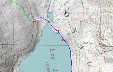
First dot on the hill is the better@Bob,
This is a segment of the map that you shared with me. Are those two red dots on the east shore of Lee Lake the area that you're talking about that had the good campsite?
View attachment 106502
Mike K
Member
- Joined
- Jul 6, 2012
- Messages
- 879
@marquiri - Kagevah Pass is steep but short. Shouldn't be much of a problem. We went over with big packs. (Of course, these were my younger fitter years). Once on top of the pass, the ridgeline up to Kagevah Peak didn't look bad at all (if I remember correctly). I bet the views from up there are spectacular! We saw some people doing it as we were going over the pass. Odyssey Peak looks cool, too.
From Bewmark Lake, the views looking towards Lee Lake and that cirque were pretty cool.
Check out some pictures here from a 2008 trip.
Pictures 78 - 98 show the views from Bewmark, what Kagevah Pass looks like, and what Kagevah Lake looks like on the other side of the pass. Let me know if you have any other questions.
- Joined
- Jul 23, 2013
- Messages
- 1,665
@WasatchWill:
Thanks so much for the route description over the pass. It matches up with what @Bob described to me. I saw in another video that it looks like there is quite a bit of knee high brush that you have to walk through if you are too low walking between Lee Lake and the pass. I think I read somewhere that you're better off not dropping all the way down (in the direction that you passed through) if you want to avoid that brush. Does that sound right?
Yeah, we walked through a bit of brush as we got near the shore of Lee, but it got really bad for a good stretch as we began skirting around Middle Fork after crossing over its inlet there.
marquiri
Member
- Joined
- Jan 15, 2018
- Messages
- 94
- Joined
- Jul 23, 2013
- Messages
- 1,665
I do, but we didn't always stay true to the line I have routed through there because there were other use trails we found ourselves joining up with and following. The rest of the way it was just picking the most direct looking line with least resistance.
Bob
Trailmaster
- Joined
- Mar 3, 2013
- Messages
- 4,897
I'll look at mine... Should be an actual trackI do, but we didn't always stay true to the line I have routed through there because there were other use trails we found ourselves joining up with and following. The rest of the way it was just picking the most direct looking line with least resistance.
Dreamer
off route
- Joined
- Jun 14, 2016
- Messages
- 321
I’ve passed by Rainbow a few times. Never camped there myself. It’s in the trees without a grand view, though nice enough. Not heavily used but I did encounter a large scout group illegally camped in the open right next to the trail once. There is established camping up slope in the trees a very small distance to the east of the trail just north of the creek coming in from the east. There are probably other established sites I’m unaware of and there are definitely other likely looking spots.
marquiri
Member
- Joined
- Jan 15, 2018
- Messages
- 94
OldBill
Member
- Joined
- Aug 18, 2015
- Messages
- 584
Great trip with @Bob last year. 3rd trip to Rainbow L. Only camped there once on a solo trip. Got hammered with hail and snow. Got my down bag wet and had to bail as next day was more of the same. 27 m in 2 days. Couple of mountain lion tracks and saw 1 person.
That section of trail in the trees may not have been cleared since the 2020 wind event. I went in 2 days after the event but hiked along the open western side, as we did last year.
That section of trail in the trees may not have been cleared since the 2020 wind event. I went in 2 days after the event but hiked along the open western side, as we did last year.
Last edited:
Don't like ads? Become a BCP Supporting Member and kiss them all goodbye. Click here for more info.

