Who uses paper maps?

i carry both gps and paper map. I believe in back ups of really important things.


I use GPS and carry map and compass. I used to compete in orienteering and it is fun to occasionally try to recall some of those skills. A few years ago I set up a small course for my wife and in-laws while backpacking in Hells Canyon. I bribed them with treats at the end.
 
I use GPS and carry map and compass. I used to compete in orienteering and it is fun to occasionally try to recall some of those skills. A few years ago I set up a small course for my wife and in-laws while backpacking in Hells Canyon. I bribed them with treats at the end.

Do you still have the treats? LOL
 
My wife made sure she found them. My mother in-law was indifferent and my father in-law was comparing me to drill sergeants from when he was in the military.
 
I've stuck with paper maps for most of my outdoor adventures. I do not own a GPS unit and honestly only take my phone out for pics if I do not take a camera. I suppose I should look at some phone apps as a backup one of these days.
 
No paper for me. GPS (and extra batteries). My phone is my backup unit. Not too often that I'm far enough off the 'beaten trail' that I couldn't find my way if both failed.
 
You really lucked out!

Mine wasn't. Mine was one of the most over opinionated people I have ever dealt with. Very loud about it too. But what are you going to do?

Well indifferent about that specific activity. We will avoid discussions about her opinions on anything else.
 
I still use a flip phone, that has very limited service in the mountains, don't own or even think of owning a GPS, so I still use paper.
 
What do you mean at the corner of 4 quads?

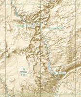
Let's take Chimney Canyon in the Swell. It's right near the corner of the 4 quads named in this image, guaranteeing a lot of map folding and futzing and aligning -- never have to do that on my phone!Screen Shot 2017-06-07 at 10.21.38 PM.png
 
Let's take Chimney Canyon in the Swell. It's right near the corner of the 4 quads named in this image, guaranteeing a lot of map folding and futzing and aligning -- never have to do that on my phone!View attachment 55114
That's why I print my own maps ;-)

Sent from my Pixel using Tapatalk
 
I work in the woods and I always carry a Garmin 64st GPS, extra batteries, a compass, and a map/ aerial photo. My phone rarely has service when I'm out but I haven't tried any GPS apps. Rite in the Rain is great waterproof paper but it only works with certain kinds of printers (they also make all sorts of notebooks/ field journals). One nice thing about the newer Garmins is that you can download aerial imagery onto the device for like $30/year. The 64 has a kinda small screen but the touchscreen ones are bigger.
 
I use both phone and paper. I wish I could print 11x17, but my printer only does up to legal/letter size of 8.5 wide. I just print to regular paper and store it in a gallon size ziplock. I get out the paper every now and then, especially on extended trips when I want to look each night and see what I'll be hiking through and by the next day. When I'm actually hiking in the day though, I usually just fire up my phone for a second and pull up the PDF map there. I use Caltopo to create PDFs for both my phone and my printer.
 
I will say that if you're going to be doing a lot of off-trail navigation/constantly having to look at your map, paper is far superior because it doesn't drain your battery.
 
I will say that if you're going to be doing a lot of off-trail navigation/constantly having to look at your map, paper is far superior because it doesn't drain your battery.

Perhaps, but it's not that black and white with where batteries are lately. Even with heavy GPS and screen use all day, my iPhone 7+ will still last a couple of days if it's otherwise in airplane mode. Throw in a battery pack to add another charge or two and it's all good for most trips. And with the added benefit of always seeing right where you are on the map. Don't get me wrong, I like paper maps too, but I'd still prefer to primarily use my phone with Gaia even for a lot of off-trail nav.
 
Perhaps, but it's not that black and white with where batteries are lately. Even with heavy GPS and screen use all day, my iPhone 7+ will still last a couple of days if it's otherwise in airplane mode. Throw in a battery pack to add another charge or two and it's all good for most trips. And with the added benefit of always seeing right where you are on the map. Don't get me wrong, I like paper maps too, but I'd still prefer to primarily use my phone with Gaia even for a lot of off-trail nav.
Yeah, for a week's trip, you'd need three or four charges with you (minus the one that's already on your phone battery) and you're still cutting it pretty close. Certainly people do it and get away with it, but it seems like a complicated solution to a simple problem. At any rate, it really comes down to a matter of taste so as long as people know how to navigate when all else fails, that's really all that matters. Me? I don't want to entrust my survival to a percent indicator that inexorably ticks down toward zero.
 
Similar threads
Thread starter Title Forum Replies Date
Nick Who uses a Buff? Gear 24
W Paper map for Teton Wilderness (Younts Peak) Gear 4
F Maps for the Bob Marshall Wilderness Resource Discussions 3
U Funny experience with Maps on iPad Everything Else 1
westy NW Wyoming Maps Trip Planning 13
T Findings while searching Google maps General Discussion 9
TrektheWorld Gazetteer Maps Gear 4
Wanderlust073 Black Ridge Canyons Wilderness / Rattlesnake Canyon maps Trip Planning 6
Jackson Google Maps 3D Detail General Discussion 4
isleroyaleguy White Clouds maps? Trip Planning 4
Mike Jones Built a Custom Map Board for protecting my maps while hiking Gear 9
Bob Create Maps/Routes for Android Resource Discussions 1
Backcountry Post Embedding CalTopo Maps Questions, Suggestions & Support 23
andyjaggy Printing Maps General Discussion 13
Mike K Maps on your phone (cheap or free) General Discussion 25
Absarokanaut NOAA June, July, and August Seasonal Outlook Maps General Discussion 16
steve Google Maps Engine Question on windows 8.1 laptop with USB gps General Discussion 0
uintahiker Google Maps vs KML file embed General Discussion 2
Nick New Google Maps Engine SUCKS General Discussion 12
baltocharlie Maps for Spring trip Trip Planning 17
Waynee-ack Maps? General Discussion 4
Backcountry Post Guess the spot: Maps Edition General Discussion 4670
Backcountry Post Embedding Maps Questions, Suggestions & Support 32
Nick Embedding Google Maps Questions, Suggestions & Support 0

Similar threads

Back
Top