- Joined
- Aug 18, 2018
- Messages
- 1,767
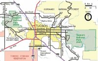
Tucson Basin is surrounded by several mountain ranges : Tucson Mountains with Wasson Peak to the west, Santa Catalina Mountains to the Northeast, the Rincon Mountains to the east of Tucson and Santa Rita Mountains to the south. Wasson peak is the highest peak in the Tucson Mountains and it can be reached via different trails. The hardest trail is the 10 mile out and back Hugh Norris Trail in the SAGUARO NP (WEST). Elevation change is about 2400 ft incl. the ups and downs on the trail. We hiked it on February 17, 2018.
This report is a continuation of a previous report: 3 week Arizona road trip : Tucson Desert Rain and Hiking SAGUARO NP.
https://backcountrypost.com/threads...ip-tucson-desert-rain-hiking-saguaro-np.8010/
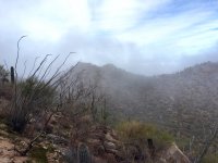
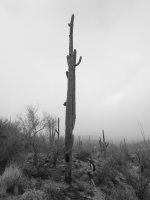
Beginning of Hugh Norris trail with a Saguaro in the fog-
A very unique desert experience with an exceptional fragrance after the rain.

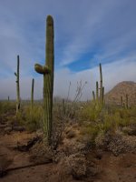
We have hiked to Wasson peak several times and it has sweeping 360 views of all mountain ranges around Tucson. The Hugh Norris trail is a very scenic and exposed ridge trail and by far our favorite approach to the peak. Despite heavy fog from a couple of days of rain in the desert, we started out early. The Hugh Norris TH is inside the boundaries of Saguaro NP West on Hohokam Road (part of Bajada scenic loop drive) and it has little parking. We just saw 2 other cars parked when we arrived and we were glad, that we didn't have to drive back to the King Canyon TH (outside of the park), because we have done that approach to Wasson peak several times. From King Canyon TH it's a shorter hike with less elevation change and you miss out on the spectacular first 2.7 miles of the Hugh Norris trail. Should you ever end up at King Canyon TH, then make sure to hike the Gould Mine trail, since it has some big Saguaros. Another area with huge Saguaros is anywhere along the scenic Bajada Loop drive or anywhere off trail in the washes, especially in the washes off Cactus Wren trail.

We are just at the beginning of the hike, Hohokam road (part of the Bajada scenice loop) is still visible


iPhone picture of tiny Rick and yes we are headed uphill into the fog.

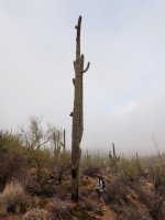
Lots of Saguaro hiding in the fog. Also a surprising amount of green ground cover and tiny ferns on the slopes


Enough fog? Cholla Cactus - best to stay away from those. Good I had my hat on, so I didn't get sunburned.....

Sun is peaking through and suddenly more Saguaro are visible. Also an usual area with lots of boulders.


Pretty section with lots of boulders. Even nicer on the way back without fog.

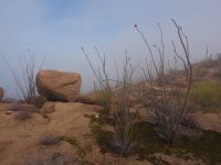
Ocotillo just starting to bloom.
It's starting to look brighter Rick said. He always sees a sliver of sunshine

Just turned a corner and Wasson peak is somewhere out there in the fog.

Looking back towards where we just came from (I think)

Looking towards the northeast

Hm..... I thought it was clearing! Now I'm wondering if the fog will ever burn off


Then we must have decided to pick up the pace and not take pictures till right before Wasson peak. But Rick photographed those beautiful sections later on the way back.
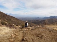
So, this is much further up on the trail after finishing a steep section of the Hugh Norris trail. First view of Tucson below.

Wasson peak in view at the intersection with the King Canyon trail

Rick - Wasson Peak. Sweeping 360 views.

In 2017 Rick took some 360 sphere pictures (now on Google map) of 2 brothers we met on top of Wasson Peak.
They later invited us out for dinner and we had a great evening!
This year Rick tried the fisheye lens.... Tucson in the distance.

Our neighbor used to live in Tucson and she misses all the hiking, so I'm always texting her from Wasson Peak, but I got caught with the fisheye lens.
View towards the south. King Canyon trail is visible creeping along the ridge (to the right of my hat).

Leaving the peak - view towards the west with King Canyon trail and it's switchbacks to the left, but we returned on the Hugh Norris trail (over the saddle)
Over the saddle, we started the switchbacks and a steep section of the Hugh Norris trail (trail on the right in the picture)

Pictures from further down on the trail


Spectacular section of the trail - hard to capture, but we love it.

Another really nice area. Lots of boulders:

Looking north

Looking back at trail we just came from

Scenic loop road visible again - still hazy after days of rain.

Almost back at the parking lot. Superb hike!

And let's finish it off with a Lizard's view of a Saguaro:

So.... I hope you enjoyed this report about the 10 mile hike to Wasson Peak via Hugh Norris Trail in the Saguaro NP WEST.
Sunday, the next day, we continued our 3 week Arizona road trip and we drove to Ajo to visit Organ Pipe Cactus National Monument on the border of Mexico, report to be continued- if you are interested in more desert stuff?.
This report is a continuation of a previous report: 3 week Arizona road trip : Tucson Desert Rain and Hiking SAGUARO NP.
https://backcountrypost.com/threads...ip-tucson-desert-rain-hiking-saguaro-np.8010/
Beginning of Hugh Norris trail with a Saguaro in the fog-
A very unique desert experience with an exceptional fragrance after the rain.
We have hiked to Wasson peak several times and it has sweeping 360 views of all mountain ranges around Tucson. The Hugh Norris trail is a very scenic and exposed ridge trail and by far our favorite approach to the peak. Despite heavy fog from a couple of days of rain in the desert, we started out early. The Hugh Norris TH is inside the boundaries of Saguaro NP West on Hohokam Road (part of Bajada scenic loop drive) and it has little parking. We just saw 2 other cars parked when we arrived and we were glad, that we didn't have to drive back to the King Canyon TH (outside of the park), because we have done that approach to Wasson peak several times. From King Canyon TH it's a shorter hike with less elevation change and you miss out on the spectacular first 2.7 miles of the Hugh Norris trail. Should you ever end up at King Canyon TH, then make sure to hike the Gould Mine trail, since it has some big Saguaros. Another area with huge Saguaros is anywhere along the scenic Bajada Loop drive or anywhere off trail in the washes, especially in the washes off Cactus Wren trail.
We are just at the beginning of the hike, Hohokam road (part of the Bajada scenice loop) is still visible
iPhone picture of tiny Rick and yes we are headed uphill into the fog.
Lots of Saguaro hiding in the fog. Also a surprising amount of green ground cover and tiny ferns on the slopes
Enough fog? Cholla Cactus - best to stay away from those. Good I had my hat on, so I didn't get sunburned.....
Sun is peaking through and suddenly more Saguaro are visible. Also an usual area with lots of boulders.
Pretty section with lots of boulders. Even nicer on the way back without fog.
Ocotillo just starting to bloom.
It's starting to look brighter Rick said. He always sees a sliver of sunshine
Just turned a corner and Wasson peak is somewhere out there in the fog.
Looking back towards where we just came from (I think)
Looking towards the northeast
Hm..... I thought it was clearing! Now I'm wondering if the fog will ever burn off
Then we must have decided to pick up the pace and not take pictures till right before Wasson peak. But Rick photographed those beautiful sections later on the way back.
So, this is much further up on the trail after finishing a steep section of the Hugh Norris trail. First view of Tucson below.
Wasson peak in view at the intersection with the King Canyon trail
Rick - Wasson Peak. Sweeping 360 views.
In 2017 Rick took some 360 sphere pictures (now on Google map) of 2 brothers we met on top of Wasson Peak.
They later invited us out for dinner and we had a great evening!
This year Rick tried the fisheye lens.... Tucson in the distance.
Our neighbor used to live in Tucson and she misses all the hiking, so I'm always texting her from Wasson Peak, but I got caught with the fisheye lens.
View towards the south. King Canyon trail is visible creeping along the ridge (to the right of my hat).
Leaving the peak - view towards the west with King Canyon trail and it's switchbacks to the left, but we returned on the Hugh Norris trail (over the saddle)
Over the saddle, we started the switchbacks and a steep section of the Hugh Norris trail (trail on the right in the picture)
Pictures from further down on the trail
Spectacular section of the trail - hard to capture, but we love it.
Another really nice area. Lots of boulders:
Looking north
Looking back at trail we just came from
Scenic loop road visible again - still hazy after days of rain.
Almost back at the parking lot. Superb hike!
And let's finish it off with a Lizard's view of a Saguaro:
So.... I hope you enjoyed this report about the 10 mile hike to Wasson Peak via Hugh Norris Trail in the Saguaro NP WEST.
Sunday, the next day, we continued our 3 week Arizona road trip and we drove to Ajo to visit Organ Pipe Cactus National Monument on the border of Mexico, report to be continued- if you are interested in more desert stuff?
.Attachments
-
 Tucson-Map_2.jpg67.3 KB · Views: 37
 -
 A-foggy-IMG_8971.jpg313.6 KB · Views: 36
 -
 tall one-P2175855.jpg257.6 KB · Views: 36
 -
 close to car-P2175834.jpg330.1 KB · Views: 36
 -
 BW early on trail-P2175857.jpg225.5 KB · Views: 35
 -
 Ocotillo-P2175925.jpg339.6 KB · Views: 36
 -
 first view of Tucson-P2176078.jpg466.8 KB · Views: 36
Last edited: