Vermillion Cliffs National Monument

Ross

Member
Joined
May 18, 2012
Messages
295
The first time I ever saw a photo of "brain rocks" I was amazed. To me it looked as surreal as The Wave.
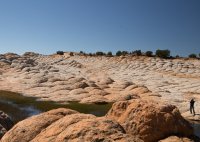
While they may not carry the colour variation of other slickrock, being predominantly white, after visiting Coyote Buttes I still wanted to go exploring further on the Sand Hills of the Vermillion Cliffs National Monument.

Not owning a good 4WD and being a bit wary of getting stuck in sand in a remote area, once my friend Des agreed to the trip we decided to go with the Paria Outpost outfitters who also know the area better than any others.
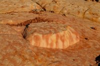
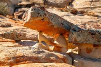
After leaving House Rock Valley road we stopped a couple of times to take in a few weird features.
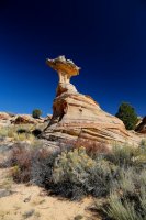
des4 904imp resized.jpg

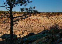
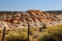
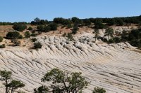
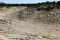
Then mid afternoon we hit Joe's Ranch - a mass of white brain rocks.

des4 926impcrop3 resized.jpg

We clambered up higher for a better view.
I guess for most people our half hour look would be enough as I'd pretty much seen it and got nice photos, but with camera in hand I could easily have run around it for another 30 minutes taking pictures from different angles. But we had to head to camp where I was told greater stuff awaited for the golden hour before sunset.
des4 940imp resized.jpg


des4 931 imp resized.jpg

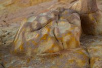
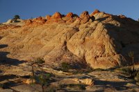
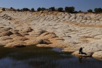
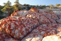
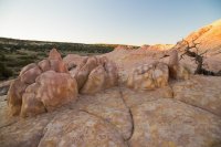
It was true. Multi coloured slickrock with all sorts of interesting micro features kept us entertained for several hours that evening.
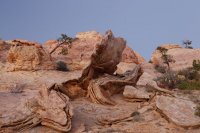
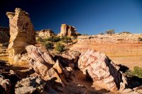
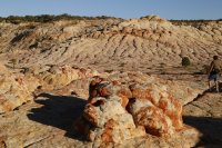
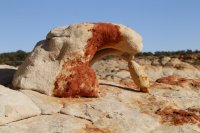
des4 1074 resized.jpg


des4 984imp trsized.jpg


des4 1004 resized.jpg


des4 958 resized.jpg


des4 1095imppano resized.jpg


des4 1015imp resized.jpg


des4 998imp2 resized.jpg


des4 1049impresized.jpg


des4 1057 resized.jpg


des4 1125imp resized.jpg


and then found more to see from dawn. (Incidentally, if anyone uses Paria Outpost this was interspersed by fantastic hearty dinner and breeakfast)
des4 1104impresized.jpg


des4 1048 imp2 resized.jpg

We hiked out to the edge of the plateau for views down over the Colorado, Marble Canyon and Lees Ferry.

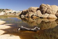
On the return we stopped for lunch at Middle Reservoir - another pretty photogenic spot.

des4 1160imppano resized.jpg


des4 1168 resized.jpg


des4 1169 imp resized.jpg


des4 1154 resized.jpg


des4 1152imp3resized.jpg
I could see within a mile or two in almost every direction more areas of orange pink and white sandstone "cauliflower" rocks and "logs" and teepees that whetted my appetite for another trip one day to explore these and Lower Reservoir (if anyone is ever interested do let me know!) even if perhaps none was in the same league as what we'd seen or Coyote Buttes, where we were to go the next day (separate trip report to follow).
 
Great pictures.. You really captured the textures and colors well. I really got a kick out of the "Rock Lizard" (maybe I am the only one seeing a rock lizard in the picture :)). Love the Vermillion Cliffs area.
des4-1125imp-resized-jpg.42922

Where did you guys camp for the night after visiting Joes Tank?
 
Last edited:
Thanks Cool Danish. Must admit I can't see a lizard in it, but someone on Facebook said it looked like two geckos with eyes. We didn't camp at Joe's. We went on a few miles south east to the edge of the cliffs to look down on the Colorado and camped near there. How many times have you been to the Monument? It was my first time further south beyond Coyote Buttes or Whitepocket (and the Paria River area if that counts), although I did go a bit along the rim of the Paria Canyon. It's a big area rarely visited because of the poor "roads" and more famous neighbours.
 
I immediately thought it looked like a lizard too. It even has an eyeball.

Great photos of some really interesting rock! Sounds like a great trip.
 
Thanks Cool Danish. Must admit I can't see a lizard in it, but someone on Facebook said it looked like two geckos with eyes. We didn't camp at Joe's. We went on a few miles south east to the edge of the cliffs to look down on the Colorado and camped near there. How many times have you been to the Monument? It was my first time further south beyond Coyote Buttes or Whitepocket (and the Paria River area if that counts), although I did go a bit along the rim of the Paria Canyon. It's a big area rarely visited because of the poor "roads" and more famous neighbours.

I have been up on the Monument 4-5 times.. Mostly visiting White Pocket and Coyote Buttes South (I haven't been able to get permits for CBN / The Wave). A good book for this area is Michael Kelsey's "Hiking and Exploring the Paria River" Lot's of history and a great description of the Sand Hills.
I have been wanting to see more of the southern part and your pictures reaffirm that.
 
So far (for me)... The Wave....A couple of trips to South Coyote Buttes and a couple of trips into the White Pocket. You have definitely shown there is much more to see up in the Sandhills. Driving the sand with confidence to all these places is the issue. Getting stuck out there would suck! Still..... Might have to see some of these places next spring.
Thanks for all the amazing pictures and showing how much more there is to see up there.
 
I have been up on the Monument 4-5 times.. Mostly visiting White Pocket and Coyote Buttes South (I haven't been able to get permits for CBN / The Wave). A good book for this area is Michael Kelsey's "Hiking and Exploring the Paria River" Lot's of history and a great description of the Sand Hills.
I have been wanting to see more of the southern part and your pictures reaffirm that.

Hi "Cool Danish". I see you said you were a fan of the Vermillion Cliffs National Monument/Sand Hills. I have 2 weeks vacation left for 1st 2 weeks October (perhaps last week Sept),but my usual companions can't go so I'm trying to decide whether to go to Utah alone & try linking with people for hikes/canyons between Zion & Page.I was thinking of a couple of days exploring the slickrock/brainrock areas in the VCNM. We passed quite a few at a distance last yr but didn't have time to get up close. I fancied new areas like Lower Reservoir/Twin Tanks/perhaps unnamed areas I could see in several directions from Middle Reservoir and wondered if you'd be interested in linking up. I wasn't going to go to Whitepocket or Cottonwood Cove in Coyote Buttes South as i've been, although don't mind stopping briefly if someone wanted to go with me if the other areas were included. Also round the back of Paw Hole about a mile or 2 hike I've not been to where Kelsey has some nice looking Wave like sandstone pictures. I'm not sure if you have a 4WD, or would want to risk taking it on sandy remote roads (could inform an outfitter I know to check we returned!), I'd happily pay all the gas. Or perhaps we could pay that outfitter to do the trip. I think he charges about $250pp if 2 people for 2 days including very big breakfast & dinner.
 
Hi "Cool Danish". I see you said you were a fan of the Vermillion Cliffs National Monument/Sand Hills. I have 2 weeks vacation left for 1st 2 weeks October (perhaps last week Sept),but my usual companions can't go so I'm trying to decide whether to go to Utah alone & try linking with people for hikes/canyons between Zion & Page.I was thinking of a couple of days exploring the slickrock/brainrock areas in the VCNM. We passed quite a few at a distance last yr but didn't have time to get up close. I fancied new areas like Lower Reservoir/Twin Tanks/perhaps unnamed areas I could see in several directions from Middle Reservoir and wondered if you'd be interested in linking up. I wasn't going to go to Whitepocket or Cottonwood Cove in Coyote Buttes South as i've been, although don't mind stopping briefly if someone wanted to go with me if the other areas were included. Also round the back of Paw Hole about a mile or 2 hike I've not been to where Kelsey has some nice looking Wave like sandstone pictures. I'm not sure if you have a 4WD, or would want to risk taking it on sandy remote roads (could inform an outfitter I know to check we returned!), I'd happily pay all the gas. Or perhaps we could pay that outfitter to do the trip. I think he charges about $250pp if 2 people for 2 days including very big breakfast & dinner.

Hi Ross,
Unfortunately all my vacation has already been used up for the year due to recent job change :( so I wont be able to take any more trips this year, besides a short 4-day trip in early September.
I have actually just been in the area back in February this year, see report here.

I do have a 4WD (Jeep Wrangler) fully capable of handling the sand and any self recovery (winch etc.) needed.

You mentioned some Wave looking sandstone from Kelsey's book 1-2 mile from Paw Hole; I did hike to this sandstone formation a couple years ago from the Paw Hole TH. See this Trip Report, 2nd day after leaving White Pocket.
F.Y.I. I am pretty sure that hiking into the area north of Paw Hole requires the Permit for Coyote Buttes South (Paw Hole might even need the permit). Here is a few pictures from the Trip Report (Sorry about the crappy pictures, midday is not the best for pictures and my white balance was completely screwed up):
dsc_0105-jpg.34108

dsc_0110-jpg.34109


Sorry we couldn't link up.. I hope your plans will still work out.
- Michael Sorensen
 
Hi Michael,
Thanks for getting back - I appreciate it.
Great pictures on your trip reports.
Although I guess you didn't make it to Happy Canyon - that's one on my list.
I'm not sure if the Paw Hole spot is the one I was thinking of, but your spot is nice all the same. Nice to see what Panorama Point looks like.
Maybe another year.
 
Similar threads
Thread starter Title Forum Replies Date
Janice Vermillion Cliffs Trip - Part 3 - Buckskin Gulch Hiking & Camping 3
Janice Vermillion Cliffs Trip - Part 2 - White Pocket & Coyote Buttes South Hiking & Camping 7
J Paria Canyon-Vermillion Cliffs Wilderness, UT-AZ Backpack: April 26-29, 2019: Days 2-4 Paria River Backpacking 3
J Paria Canyon-Vermillion Cliffs Wilderness, UT-AZ Backpack: April 26-29, 2019: Day 1 Buckskin Gulch Backpacking 2
Ross Sand Hills/Vermillion Cliffs NM hoodoos & brainrock Trip Planning 0
Cool Danish Vermillion Cliffs NM – Winter 2016 Hiking & Camping 5
Laura Looking for a place to take a photograph from the top of the Vermillion Cliffs Trip Planning 4
FourisTheNewOne Vermillion Cliffs - NatGeo article General Discussion 0
kwc Good Luck Cliffs in Winter 3/22/23 Hiking & Camping 0
kwc Good Luck Cliffs, Southern Adirondacks Hiking & Camping 0
fossana Red Cliffs & Dixie NF fire-related trail/road closures (St George area) Trip Planning 1
Artemus Road Proposed to be Bulldozed through Red Cliffs Recreation Area General Discussion 7
Jazzy Joe A Lucky Weekend above the Vermilion Cliffs Hiking & Camping 8
zionsky Candy Cliffs Trip Planning 2
fossana Red Cliffs Après Work Scramble Hiking & Camping 3
Noureddine Djanet ...wide canyon , steep sided cliffs & verdant plants Off Road 4
SKLund Back Country Permit Orange Cliffs Trip Planning 8
Scott Chandler A Square 1/2 mile in the Red Cliffs Hiking & Camping 5
hamtron5000 Little Book Cliffs Wilderness Study Area Backpacking 3
hatchcanyon Book Cliffs: Horse Canyon Off Road 0
Kullaberg63 Book Cliffs. Anybody go there? Trip Planning 5
Udink Book Cliffs Trail Hiking & Camping 6
Seldom Seen Anderson Arch Trail, Red Cliffs Hiking & Camping 1
Jammer Red Cliffs Conservation Area Backpacking 5
IntrepidXJ The Vermilion Cliffs to The Grand Staircase Hiking & Camping 6
Seldom Seen Anderson Arch Trail Red Cliffs Hiking & Camping 8
Tyler Red Cliffs National Recreation area Feb. 2010 Hiking & Camping 14
Tyler Spring Break 2011: Zion, Snow Canyon, Red Cliffs Hiking & Camping 0
pixie1339 Zion, Snow Canyon & Red Cliffs New Years 2012 Hiking & Camping 16
Seldom Seen Anderson "Discovery" of Vermilion Cliffs General Discussion 8
TheMountainRabbit News Release: Yellowstone National Park increases protection for bears and visitor safety by implementing changes to two bear management areas General Discussion 14
scatman The Gallatin River, Bighorn and Fawn Passes, Yellowstone National Park - September 7, 2023 Backpacking 14
futurafree government shutdown effects on national forests? General Discussion 21
BJett Packrafting the Obed National Wild & Scenic River - Tennessee On The Water 1
fossana New Baaj Nwaavjo I'tah Kukveni National Monument General Discussion 4
J York Fire, Mojave National Preserve. Aug 2023 Resource Discussions 3
Janice Field Trip - Washington Post podcast about national parks General Discussion 0
I Rescue Creek - Yellowstone National Park - June 3, 2023 Backpacking 15
scatman Rescue Creek - Yellowstone National Park - June 3, 2023 Backpacking 56
TractorDoc Cuyahoga Valley National Park (again!) 06/04/2023 Hiking & Camping 6
TractorDoc Cuyahoga Valley National Park 05/28/2023 Hiking & Camping 20
scatman Rescue Creek - Yellowstone National Park Meet Up (Members Only) 19
D Need suggestions -Beaverhead-Deerlodge National forrest, and Phillipsburg, MT Trip Planning 5
Ted California couple killed in Yosemite National Park rockslide identified by park officials General Discussion 0
NorthwestWanderer Backpacking Grand Teton National Park : Fossil Pass,Fox Creek Pass,Indian Lake,Alaska Basin,Hurricane Pass,Ice Floe Lake,& Snowdrift Lake Backpacking 19
fossana New National Monument planned in Southern NV General Discussion 3
canadug Hiker death in Zion National park :( Hiking & Camping 32
F Frontenac National Park, Quebec, Canada Hiking & Camping 2
J Mojave National Preserve Monsoon Aug. 3, 2022 Trip Planning 2
scatman Shoshone Lake Lollipop Loop - Yellowstone National Park - July 24, 2022 Backpacking 63

Similar threads

Back
Top