- Joined
- Feb 15, 2020
- Messages
- 580
I'm continuing my effort to document some previous trips here and I figure I'll keep working backwards on my yearly trips w/ my brother to get started. (He's better about taking pictures than me, so it makes for a better trip report.) This trip took place in Denali National Park in mid-August 2018 and is very different than the two trips previously documented in Yellowstone - most notably because those trips went so smoothly. To say this one did not is a pretty big understatement - this one was dominated by what you might call "Type 2 Fun". Obstacles were overcome and lessons were learned, but thankfully our bodies and spirits emerged mostly unscathed.
Anyone that has backpacked in Denali is aware that - for the most part - advanced plans/reservations are not really a thing. You walk in to get your wilderness permit with ideas, but typically don't create a solid plan until speaking with the rangers. I really enjoyed this aspect of the trip and we got what seemed like a pretty solid itinerary. (Under different conditions and with better execution, I still think it would be great.) We got permits to hike up the western fork of the Upper Toklat River (2 nights) and then cross over to the Sunrise/Sunset Glaciers (2 nights) and then catch a bus at the Eielson Visitor Center. Easy-peasy.
Day 1: Bus Ride to Toklat; Hike to West Branch of Upper Toklat
Our first day really was a cake walk: we got our permits, visited the sled dog kennels, volunteered to participate in a grizzly scat study, took the bus to the Toklat River, and enjoyed very mellow walking along gravel bars all the way to our first night camp. There were a few (very) chilly crossings of the river and not much sunlight, but it was otherwise a beautiful start to our trip.
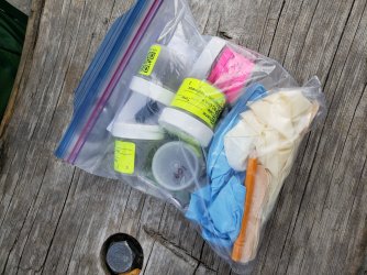
Our grizzly scat kit: five vials for the "samples" w/ a pair of gloves and wooden collection stick for each. Upon collection, there was also a GPS device to activate at each location. We ended up collecting/returning three samples: two marked pretty low for freshness, but one that was practically still steaming. We didn't see any bears while hiking, but their presence was very clear via prints, picked over soapberry bushes, and the complete destruction of many rodent burrows.
The bus ride out to the Toklat River was a trip unto itself. We would get very accustomed to the braided nature of Alaska's rivers by the end of our trip.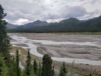
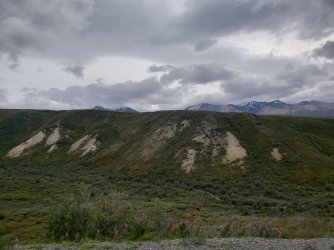
Not a great picture, but we did see a few grizzlies on our bus ride. We watched a mother grizzly (light colored dot in picture below) with two cubs for quite a while. (This was my brother's first grizzly sighting ever.)
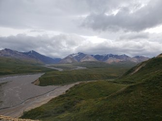
Watching the bus leave us behind was a pretty cool experience - there would be no available "bail out" until the first bus the next day.
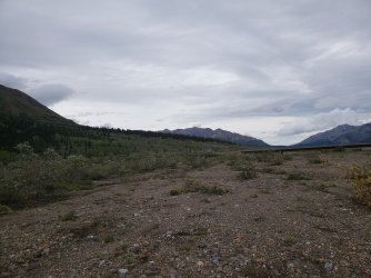
The walking along the river was great - no trails, but who needs one along these gravel bars? The water crossings were another matter entirely; they weren't particularly deep, but the water was moving very quickly and the river bottoms were the most unstable I've encountered. (Day 3 of our trip would really drive some of this home...)
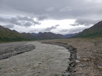
Other than a few solitary caribou, we did not see much in the way of wildlife. It's presence was clear via large numbers of tracks in the relatively fresh mud - we saw evidence of wolf, caribou, grizzly, Dall sheep, and many smaller animals reflected via their respective tracks.
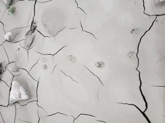
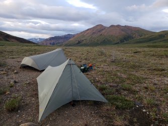
Our first night campsite was in a beautiful flat meadow before the Toklat River's upper west branch fragmented further - the following day we would follow the western path. (Right side of the first picture below.)
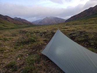
Day 2: West Branch of Upper Toklat to Scott Peak Glacier(s)
We were incredibly excited for this day - my brother had never previously seen a glacier up close and my glacier experience had been limited to those (comparatively) smaller ones found in the Winds and Tetons. We weren't planning on significant glacier travel, but getting up close and personal was pretty awesome. Weather was reasonably cooperative though it was gray and misty and getting grayer and mistier every minute.
Early in the day we would spot our first cut bank in the distance - the rangers had given us an idea of where we would find these and which could present a problem and/or force a river crossing. With the relatively low river, these weren't much of a problem. (That would change.)
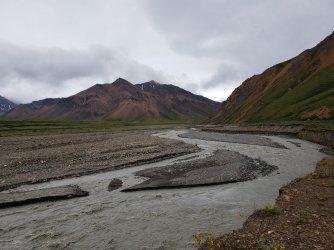
View from "inside" a rock cut bank - this one was fairly easy to traverse w/o forcing a river crossing. Some were much more undercut, which only presented two options: 1) cross the river - normally twice; or 2) climb the ridge above - sometimes easy, sometimes impossible.

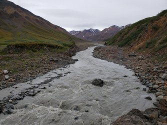
As we entered higher elevations, there was a distinct "otherworldy" feel to the vegetation-less terrain. There were occasional blotches of vegetation along the mountainsides - at one point we saw a herd of Dall sheep grazing from a long distance - but it was mostly just rock, ice, and water.
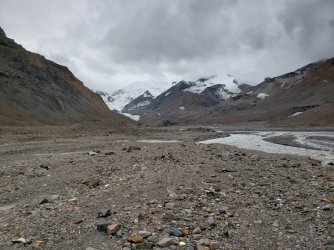
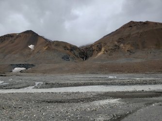
Even this far upriver where the water was much shallower, it was still moving quickly enough to sweep a person off their feet quite easily. The instability of the river bottom was only increased, as well.
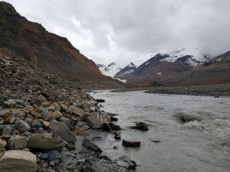
I regret not getting an "after picture", because while we were standing here a very large chunk of ice broke off of the bottom of this "cave". It gave a pretty satisfactory answer to my brother's question about whether it was safe to enter.
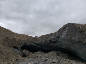
Scott Peak (8,828') was only intermittently visible, but dominated our view to the south. It was (and still is) a bit mind-boggling that Denali (20,310') is only ~30 miles away, but well over 10,000' higher in elevation.
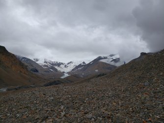
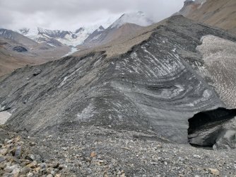
We backtracked a bit to begin our climb and our crossing into the Sunrise/Sunset Glaciers zone... this is when the weather really began to turn and where I made our first mistake.
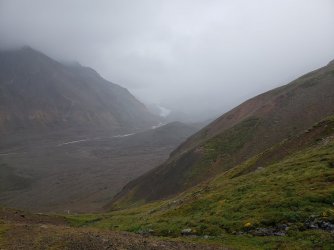
When the clouds began to roll in and the winds began to pick up, I should have led us back down into the valley where there was at least some protection. Instead - in an effort to to not retrace steps and get a start on our next day - I had us set up camp on a fairly exposed ridge. (In retrospect, that's a pretty obvious error, but not one I'll make again.)

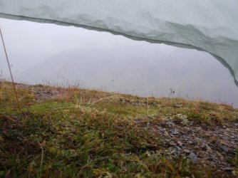
This is the last picture I took on our trip - it probably goes w/o saying: that's not a great sign. Once the wind picked up and the rain really started, it never stopped. Neither of us got more than half an hour of sleep and much of the night was spent maintaining the integrity of our respective tents and attempting to keep things as dry as possible. (Not very dry - for the record.)
Day 3: Retreat
There are no pictures of Day 3, but it was pretty easily the most exciting day I've ever spent in the backcountry - that's both good and bad, I guess. The weather alternated between bad and worse all day - the best parts of the day were a steady wind and constant cold, fine mist; the worst were gusts of at least 40 MPH and sustained rain. The sun declined to make any appearance.
Upon "waking up" - AKA giving up on the idea of sleep - it became pretty clear that the smart move would be to abandon our continued ascent and return the way we had come. We packed up and began our descent, but upon arriving in the valley it became pretty clear we had a problem: yesterday's tough, but passable river crossings had turned into the most terrifying water I've ever seen - and we were still significantly upstream. There was little chance they would get any better - between the continued rain and glacial melt it would be days before any improvement was likely.
We did have one thing working in our favor: we were on the right side of the river and in theory we didn't have to cross to get back to the road. However, that brings us back to the previously mentioned cut banks. Any that had required river crossings would now require the ridge above to be passable and any that we had barely squeaked by might have changed significantly. (There were three in particular that concerned us.)
I made my second mistake when we ran into our first and - it would thankfully turn out - worst obstacle: I got frustrated and decided to "just go". This is where my brother made sure he had a hiking partner for life and laid down the law, saying he absolutely would not follow me up a sketchy climb. He was right and I'm glad I listened. We re-pitched our tents and pulled out the maps.
It turned out we would still need to make the climb, but there was a much better spot to do it - we also really needed a waterfall coming back off of the ridgeline to "go" or we would hit a dead end. Fortunately the waterfall did "go" with only a few Class 3 sections and actually put us past two of our most concerning cut banks. Realizing we were in a good position really boosted lagging spirits and the rest of the hike out was much more pleasant - despite the conditions only continuing to worsen.
The third cut bank of concern required a little creative maneuvering, but with a little teamwork to get the bags through it turned out to be pretty doable (but probably not recommended).
From here our luck took a pretty good turn and we managed to hit the road right as a camper bus was passing by. Back to civilization and pizza.
Day 4-5: Anchorage and the Kenai Peninsula
Waking up on Day 4 was another low point - after all we were supposed to still be in the wilderness, but instead we were in a not-particularly-nice Anchorage hotel. We decided to turn "lemons to lemonade" and - after we finished drying out our gear - we headed down to the Kenai Peninsula for some exploration/hiking. After multiple days of barely seeing the sun in the Alaska Range, the weather down there was so pleasant it was almost annoying.
Between eating a ton of great seafood and getting some day hikes in, I'd say we more than sufficiently "salvaged" our trip.
In return for reading my Day 3 wall-of-text above, here are some pictures from the pretty awesome day hike up to the Harding Icefield from Exit Glacier.
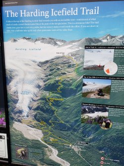
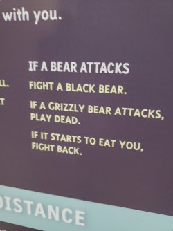
Kenai Fjords NP wins the award for my favorite government-endorsed bear attack instructions.
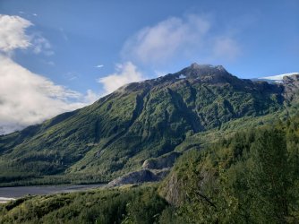
Exit Glacier
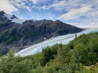
"Exiting" the Harding Ice Field.
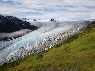
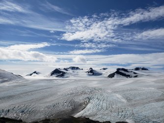
Harding Ice Field
Overall it was a phenomenal experience and my first backcountry trip to Alaska - I've been fortunate to return a few times in the years since. The following year I managed to get north of the Arctic Circle to Gates of the Arctic NP for a week-long trip, plus a few nights in the Chugach NF. This year I'll be doing some some fishing along the Kenai River with family and plan to again sneak a few nights in the Chugach. Hopefully gonna get to Wrangell-St. Elias NP for 10 days in 2022 and working toward my long-term goal to traverse the Aniakchak caldera, but there's basically an unlimited number of other adventures to be had as well.
Anyone that has backpacked in Denali is aware that - for the most part - advanced plans/reservations are not really a thing. You walk in to get your wilderness permit with ideas, but typically don't create a solid plan until speaking with the rangers. I really enjoyed this aspect of the trip and we got what seemed like a pretty solid itinerary. (Under different conditions and with better execution, I still think it would be great.) We got permits to hike up the western fork of the Upper Toklat River (2 nights) and then cross over to the Sunrise/Sunset Glaciers (2 nights) and then catch a bus at the Eielson Visitor Center. Easy-peasy.
Day 1: Bus Ride to Toklat; Hike to West Branch of Upper Toklat
Our first day really was a cake walk: we got our permits, visited the sled dog kennels, volunteered to participate in a grizzly scat study, took the bus to the Toklat River, and enjoyed very mellow walking along gravel bars all the way to our first night camp. There were a few (very) chilly crossings of the river and not much sunlight, but it was otherwise a beautiful start to our trip.
Our grizzly scat kit: five vials for the "samples" w/ a pair of gloves and wooden collection stick for each. Upon collection, there was also a GPS device to activate at each location. We ended up collecting/returning three samples: two marked pretty low for freshness, but one that was practically still steaming. We didn't see any bears while hiking, but their presence was very clear via prints, picked over soapberry bushes, and the complete destruction of many rodent burrows.

The bus ride out to the Toklat River was a trip unto itself. We would get very accustomed to the braided nature of Alaska's rivers by the end of our trip.

Not a great picture, but we did see a few grizzlies on our bus ride. We watched a mother grizzly (light colored dot in picture below) with two cubs for quite a while. (This was my brother's first grizzly sighting ever.)


Watching the bus leave us behind was a pretty cool experience - there would be no available "bail out" until the first bus the next day.

The walking along the river was great - no trails, but who needs one along these gravel bars? The water crossings were another matter entirely; they weren't particularly deep, but the water was moving very quickly and the river bottoms were the most unstable I've encountered. (Day 3 of our trip would really drive some of this home...)

Other than a few solitary caribou, we did not see much in the way of wildlife. It's presence was clear via large numbers of tracks in the relatively fresh mud - we saw evidence of wolf, caribou, grizzly, Dall sheep, and many smaller animals reflected via their respective tracks.

Our first night campsite was in a beautiful flat meadow before the Toklat River's upper west branch fragmented further - the following day we would follow the western path. (Right side of the first picture below.)


Day 2: West Branch of Upper Toklat to Scott Peak Glacier(s)
We were incredibly excited for this day - my brother had never previously seen a glacier up close and my glacier experience had been limited to those (comparatively) smaller ones found in the Winds and Tetons. We weren't planning on significant glacier travel, but getting up close and personal was pretty awesome. Weather was reasonably cooperative though it was gray and misty and getting grayer and mistier every minute.
Early in the day we would spot our first cut bank in the distance - the rangers had given us an idea of where we would find these and which could present a problem and/or force a river crossing. With the relatively low river, these weren't much of a problem. (That would change.)

View from "inside" a rock cut bank - this one was fairly easy to traverse w/o forcing a river crossing. Some were much more undercut, which only presented two options: 1) cross the river - normally twice; or 2) climb the ridge above - sometimes easy, sometimes impossible.


As we entered higher elevations, there was a distinct "otherworldy" feel to the vegetation-less terrain. There were occasional blotches of vegetation along the mountainsides - at one point we saw a herd of Dall sheep grazing from a long distance - but it was mostly just rock, ice, and water.


Even this far upriver where the water was much shallower, it was still moving quickly enough to sweep a person off their feet quite easily. The instability of the river bottom was only increased, as well.

I regret not getting an "after picture", because while we were standing here a very large chunk of ice broke off of the bottom of this "cave". It gave a pretty satisfactory answer to my brother's question about whether it was safe to enter.

Scott Peak (8,828') was only intermittently visible, but dominated our view to the south. It was (and still is) a bit mind-boggling that Denali (20,310') is only ~30 miles away, but well over 10,000' higher in elevation.


We backtracked a bit to begin our climb and our crossing into the Sunrise/Sunset Glaciers zone... this is when the weather really began to turn and where I made our first mistake.

When the clouds began to roll in and the winds began to pick up, I should have led us back down into the valley where there was at least some protection. Instead - in an effort to to not retrace steps and get a start on our next day - I had us set up camp on a fairly exposed ridge. (In retrospect, that's a pretty obvious error, but not one I'll make again.)

This is the last picture I took on our trip - it probably goes w/o saying: that's not a great sign. Once the wind picked up and the rain really started, it never stopped. Neither of us got more than half an hour of sleep and much of the night was spent maintaining the integrity of our respective tents and attempting to keep things as dry as possible. (Not very dry - for the record.)

Day 3: Retreat
There are no pictures of Day 3, but it was pretty easily the most exciting day I've ever spent in the backcountry - that's both good and bad, I guess. The weather alternated between bad and worse all day - the best parts of the day were a steady wind and constant cold, fine mist; the worst were gusts of at least 40 MPH and sustained rain. The sun declined to make any appearance.
Upon "waking up" - AKA giving up on the idea of sleep - it became pretty clear that the smart move would be to abandon our continued ascent and return the way we had come. We packed up and began our descent, but upon arriving in the valley it became pretty clear we had a problem: yesterday's tough, but passable river crossings had turned into the most terrifying water I've ever seen - and we were still significantly upstream. There was little chance they would get any better - between the continued rain and glacial melt it would be days before any improvement was likely.
We did have one thing working in our favor: we were on the right side of the river and in theory we didn't have to cross to get back to the road. However, that brings us back to the previously mentioned cut banks. Any that had required river crossings would now require the ridge above to be passable and any that we had barely squeaked by might have changed significantly. (There were three in particular that concerned us.)
I made my second mistake when we ran into our first and - it would thankfully turn out - worst obstacle: I got frustrated and decided to "just go". This is where my brother made sure he had a hiking partner for life and laid down the law, saying he absolutely would not follow me up a sketchy climb. He was right and I'm glad I listened. We re-pitched our tents and pulled out the maps.
It turned out we would still need to make the climb, but there was a much better spot to do it - we also really needed a waterfall coming back off of the ridgeline to "go" or we would hit a dead end. Fortunately the waterfall did "go" with only a few Class 3 sections and actually put us past two of our most concerning cut banks. Realizing we were in a good position really boosted lagging spirits and the rest of the hike out was much more pleasant - despite the conditions only continuing to worsen.
The third cut bank of concern required a little creative maneuvering, but with a little teamwork to get the bags through it turned out to be pretty doable (but probably not recommended).
From here our luck took a pretty good turn and we managed to hit the road right as a camper bus was passing by. Back to civilization and pizza.
Day 4-5: Anchorage and the Kenai Peninsula
Waking up on Day 4 was another low point - after all we were supposed to still be in the wilderness, but instead we were in a not-particularly-nice Anchorage hotel. We decided to turn "lemons to lemonade" and - after we finished drying out our gear - we headed down to the Kenai Peninsula for some exploration/hiking. After multiple days of barely seeing the sun in the Alaska Range, the weather down there was so pleasant it was almost annoying.
Between eating a ton of great seafood and getting some day hikes in, I'd say we more than sufficiently "salvaged" our trip.
In return for reading my Day 3 wall-of-text above, here are some pictures from the pretty awesome day hike up to the Harding Icefield from Exit Glacier.

Kenai Fjords NP wins the award for my favorite government-endorsed bear attack instructions.


Exit Glacier

"Exiting" the Harding Ice Field.

Harding Ice Field

Overall it was a phenomenal experience and my first backcountry trip to Alaska - I've been fortunate to return a few times in the years since. The following year I managed to get north of the Arctic Circle to Gates of the Arctic NP for a week-long trip, plus a few nights in the Chugach NF. This year I'll be doing some some fishing along the Kenai River with family and plan to again sneak a few nights in the Chugach. Hopefully gonna get to Wrangell-St. Elias NP for 10 days in 2022 and working toward my long-term goal to traverse the Aniakchak caldera, but there's basically an unlimited number of other adventures to be had as well.
Last edited:
