Uintas Highline Trail Solo Thru Hike - Getting to/from trailheads logistics

There isn't an official parking area, but there's plenty of space to park and it's totally cool to leave your car there. You can walk across the river there, or just start heading upstream and you'll probably be able to find a log or something further up to keep your feet dry.

Cool, thanks Nick! Created a new route starting from West Fork Black's Fork:

http://caltopo.com/m/3G14

There's a lot of good info and pictures for most of the areas along the highline trail, but for days 7-9 I couldn't find as much information. So, I'm not sure how good of a hike those last 3 days will be but given the lack of east/west routes there isn't much choice unless I want to repeat the same trails twice. But I'm sure it will be spectacular either way.
 
That's one heck of a route. If it takes longer than you expect, you can always bail out and back to your starting point at Red Castle via Bald Mountain or Henry's Fork and still have a totally awesome loop. Or even Little East Fork. Lots of good options. If you don't come back and post a trip report from that awesomeness, we're going to hunt you down and extract one from you. ;)
 
Another question... If one were at Priord lake, is there any route that traverses the backbone of the Uintas? Up and over to get from the North slope to South slope? I know people do the Priord/Allsop loop, and there is a pass near Yard Peak allowing access from Priord to Allsop lakes, but is there a pass taking you from Allsop over to Dead Horse? I haven't seen any indication of passes at the spots above, but if so that would open my route up to more options. Between Allsop and Dead Horse there looks like a saddle (marked 11660') that might work, but I don't see any routes from Priord or Allsop over to the south slope.
 
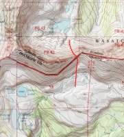
The pass just east of 'Priord Peak' is doable. There may be some remnant of a sheep trail up it, but for the most part it's just steep rocks now. Probably not easy at all, but doable.

priord-pass.jpg
 
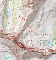
Oh sorry, I misunderstood. Yes, you can cross over between Allsop and Dead Horse. I hear the north end of that pass is the best part. Also steep and loose, but doable.

This is the best path, from what I've heard.

allsop-dhl.jpg
 
Oh sorry, I misunderstood. Yes, you can cross over between Allsop and Dead Horse. I hear the north end of that pass is the best part. Also steep and loose, but doable.

This is the best path, from what I've heard.

View attachment 32524
Coming in late here... I've been over this ridge where Nick drew the redline. It is doable but spicy. I followed the redline or so and was able to get down the west side on some steep ledgy stuff but it had loose rock all over the ledges and was nerve racking. Even found a horse skeleton with a pack still attached and semi-intact. My partner descended a little farther south by the true pass or low point. Say 1660 in the pic. He went down a scree gully which was steep and loose but he said it was straightforward. Course he is a mountaineer. We did this all with packs on. So, Nick is right it is doable but caveat emptor.
 
Thanks Nick, I was indeed asking about both passes which you posted screenshots of. I should have been more clear about it. Well that's good that they are doable, this opens up more options for me. I'd be interested to see any pictures of these routes if anyone snapped a few while traversing these.

Art, thanks for that info. I'd be doing it with a pack as well. Definitely will leave the horse at home for this one.
 
Well it looks like there is some interest then! Sounds like it'd be easier just to uber from SLC to Leidy and then uber from Mirror Lake to SLC vs getting a rental car and driving to Mirror Lake and then ubering (is that a word?) to Leidy, hiking back to the car and driving myself back to SLC.

John McKeen and Parma, what would you charge to drive from SLC to Leidy and Mirror Lake to SLC on the return?

Since my dates are flexible, maybe if there is someone else wanting to hike the highline trial in August we could plan our trips to start and/or end at the same time and share a ride/split costs? I think that would be the icing on the cake. With another person or two to split costs with, I think I'd also consider getting that rental car so that our uber ride would be shorter (from mirror lake to leidy) and then would not have to wait for a ride on the return from mirror lake to SLC as we could just get in the car and go.
There's zero cell service at any of these locations in the Unitas to be able to even request an uber. The only way would be to schedule a pickup from someone that knows when your coming out.


Sent from my iPad using Tapatalk
 
Thanks Nick, I was indeed asking about both passes which you posted screenshots of. I should have been more clear about it. Well that's good that they are doable, this opens up more options for me. I'd be interested to see any pictures of these routes if anyone snapped a few while traversing these.

Art, thanks for that info. I'd be doing it with a pack as well. Definitely will leave the horse at home for this one.
 
In regard to acclimating, take a look at moonlakeresort.com . It sets at 8000 ft . You can hike a big loop from there and go over Rocky Sea pass, Deadhorse , Red Knob and even over to Porcupine pass.
Acclimating is very important. I live at 900 ft and I flew out and attempted the Highline back in 08/13. I started at Leidy peak the next day and on my 2nd night I had HAPE. Fluid was building in my lungs. I didn't sleep at all. I ignored it and hiked 5 days total before I hiked out. On my 5th day hiking I was coughing up some bad stuff including blood. HAPE can happen to the most fit hikers. I had been a runner for 12yrs and had ran a half marathon but failure to acclimate got the best of me. I made it over Anderson pass on day 4 but I was running a fever the whole time and was exhausted. I'm going back on August 16th and am staying at moonlakeresort and I won't hike until the 19th.
I gave up on finishing the Highline this time because of the whole shuttle situation. The last time, I rented two cars, dropped one off at Mirror Lake and my wife dropped me off at Leidy and then she went to Co.
I don't really care anymore if I finish the Highline, I just want to finish the passes and enjoy the views and spend most of a day and night at Crater lake southwest of Red Knob pass. Check out moonlakeresort.com , see where it is on the map and what kind of hike you can plan. They might be all booked up though. .........Nick and everyone on here all have great advice. I should have listened to Nick when he suggested that I car camp somewhere and acclimate. Goodluck!


The moon lake Resort looks nice, but what I'm thinking now is driving to Hayden Pass the night I get in from the airport and sleeping out there for the night at 10k feet. The next morning, drive to west fork black forks and start hiking early afternoon. I'd only be hiking about 6 miles and 700ft elevation gain the first day. This way I at least spend one night at elevation, where I can drink plenty of water and rest, and still cover a few easy miles the next day. But this would still only give me about 12 hours of time at 10k fete before the hike. I've never had a problem acclimating before, although I generally try to give it more time. Least amount of acclimation time I'e had would be coming driving from Michigan to Denver and staying one night at 5,000ft and the next day driving to Aspen and sleeping at 10,800ft after 8 miles of hiking on the first day. I had a slight headache but was completely fine the rest of the trip. So I'm thinking I'll be alright acclimation wise.

However, I'm still not convinced my rental car will make it to the West Fork Black's Fork trailhead, right before the river crossing. All the maps I've seen show this as a 4x4 road. My rental car will be a Chevy Spark (or similar), so that 4x4 road is going to have to be awful smooth to accommodate such a car.
 
Well, I spent much of the day yesterday fooling around with my route. Decided not to start from west fork blacks fork, but probably east fork blacks fork instead. Since I am looking to take it easy my first day due to acclimation reasons, it's kinda limiting as to where i can start from. My old route had 3 long days at the end of the hike over lots of ups and downs, and outside of the wilderness boundary. I would have preferred to do any east/west travel closer to the divide, but there are no routes paralleling the divide unless they are closer to the trailheads. So I came up with this new route:

http://caltopo.com/m/737R

I really wanted to include Dead Horse/Priord/Allsop/Triangle Mountain and everything over in that area, but doing so would just be too much of a pain logistically. I'd have to either cover the same ground twice, go over tons of off trail passes just to cover a few miles, or go way out of my way following trails in the drainages to get anywhere. In the end I figured it'd be best just to leave that stuff out and save it for another time. Maybe someday I'll be able to hike the highline trail from one end to the other, but not this year.

This loops is also laid out a little better, since I'll be closer to King's Peak the day I'm going to attempt the summit allowing me to get up and down before mid day. Also, I designed my 5th day to include a lot of ridge walking, between Chepeta and Fox Lakes., so that should be fun. Only 2 nights where fires aren't allowed, and I should have trees near camp every night, which is important since I'll be bringing my hammock.
 
Last edited:
Any suggestions for a place to camp along HWY 150 the night I arrive? It'll probably be around midnight before I get there, so i don't really want to roll into a campground and wake everyone up. Are there any campsite pulloffs along the road I could stop at, or is it pretty much limited to the designated campgrounds like Mirror Lake, etc?
 
Cool, I figured there would be. Nowhere in particular, it's just a place to sleep overnight and get acclimated, and I'll continue on to East Fork Black's Fork trailhead in the morning. As high as possible really. I'd just like to have a general idea of where to camp before I head out there since I'll be looking for it in the middle of the night. And I'll be in a Chevy Spark or similar small car, so I don't want to end doing any serious off-roading either looking for a place to camp overnight.
 
A lot of the dirt roads require HC 4WD. There are more options between Kamas and Bald Mountain Pass up high then there are on the other side of the pass. You might have better luck camping near your starting trailhead since most of the crowds gravitate to 150.
 
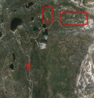
There are spots just past Provo River Falls on the left and tons more spots to the left sitting at the base of Bald Mountain right before ascending the pass there. However, those are often pretty full whenever I've driven by. Since you'll be bringing a hammock though, you may not have to be too picky about a good site, especially if you're just pulling over for a quick snooze.

Screen Shot 2015-07-28 at 10.22.39 PM.png
 
There are spots just past Provo River Falls on the left and tons more spots to the left sitting at the base of Bald Mountain right before ascending the pass there. However, those are often pretty full whenever I've driven by. Since you'll be bringing a hammock though, you may not have to be too picky about a good site, especially if you're just pulling over for a quick snooze.

View attachment 32706

Awesome, thanks for that image. That ought to be enough to give me a few places to look for when I arrive. It'll be a wednesday night so hopefully not too packed out there.
 
As promised, here's a trip report:

http://metalbackpacker.com/high-uintas-wilderness-utah-8-day-hike-aug-2015/

I ended up trimming down the route a little more, and cut off everything east of Milk Lake. I wanted to camp an extra day at Red Castle and this was the best way to do that. The route ended up being 95+ miles. I still haven't gotten a chance to edit any of the video, nor add a full photo gallery for this hike to the blog, but what I have posted already should suffice for most ;)
 
Similar threads
Thread starter Title Forum Replies Date
natylka 100 miles of Highline trail in Uintas Trip Planning 39
mathew highline trail uintas Trip Planning 23
JoeJoeMeek Uintas Highline Trail General Discussion 18
Nick Uintas Highline Trail 2012 Trip Planning 58
Nick Uintas: Highline TH to West Fork Black's Fork Backpacking 51
Tarp Boy Looking for Shuttle service for Uintas Granddaddy basin trip Trip Planning 0
2eez4life Suggestions: Uintas Backpacking with some rock climbing routes Trip Planning 0
regehr (Uintas) Lake Fork Fun Backpacking 8
scatman Reid's Peak - Uintas - July 22, 2023 Hiking & Camping 6
Upgrayedd Uintas Conditions 2023 Trip Planning 39
NorthwestWanderer First time in the High Uintas | Red Castle SNEAK Loop | I give these mountains 5 out of 5 stars Backpacking 7
2eez4life Uintas Conditions 2022 Trip Planning 18
regehr Uintas this weekend? Trip Planning 4
2eez4life 4 days 3 nights in the Uintas Trip Planning 9
6 Uintas Trip Planning Trip Planning 5
Perry Sunrise/Sunset Uintas Marriage Proposal Location Suggestions Trip Planning 25
N Gilbert Meadows- High Uintas Trip Planning 0
Upgrayedd Uintas Conditions 2021 Trip Planning 9
WasatchWill The High Uintas 4-4-4: Four Basins, Four Passes, Four Days Backpacking 20
C High Uintas Wilderness - Last minute plans Trip Planning 4
Mountain Wanderer High Uintas Wilderness - Granddaddy Basin Backpacking 4
scatman Bourbon Lake, Uintas - July 11, 2020 Hiking & Camping 4
ridings82 Uintas Backpacking Loop Trip Reports 12
Upgrayedd Uintas Conditions 2020 Trip Planning 69
B Uintas question Hiking & Camping 3
Tarp Boy Uintas in late June? Trip Planning 10
Born to Hike Mountain Solitude: Reconnaissance Lake, High Uintas, early Sept 2019 Backpacking 9
Ehouston24 Uintas Loop (Red Castle/Kings Peak) Trip Planning 14
DrNed Plan B to High Uintas Backpacking Trip Planning 20
J Uintas Conditions 2019 Trip Planning 209
DrNed Recommendation for 35-45 Mile Route in the Uintas Trip Planning 7
Yvonne A weekend in the Uintas Hiking & Camping 10
WasatchWill 5 Guys on a Trail: A Tour of the Southwestern Uintas Backpacking 12
wabenho Rainbow Lake, Uintas - September 2018 Backpacking 6
DesertRatShorty Solitude in the Uintas -- Gilbert Lake Loop Backpacking 14
jdfut66 Uintas - Priord Lake to Deadhorse Lake Loop Backpacking 6
Born to Hike Clements Lake and East Basin in the High Uintas, mid-July 2018 Backpacking 6
TrektheWorld Need help with Uintas trip - camping Trip Planning 8
Perry Missing hiker in Uintas - Ray Humpherys General Discussion 104
Mike K Uintas Three Nighter Backpacking 13
LarryBoy In Which I Forget Sunscreen (Uintas 2015) Backpacking 11
Brian Handsaker Uintas Backpacking (or Montana) Trip Planning 9
Dave Uintas Conditions 2018 General Discussion 210
Uncle_Dim October in the Uintas Trip Planning 2
Perry Late Season Uintas Day Hike Ideas. Bear River to WFBF and Back? Trip Planning 13
r3biker Backpacking trip to Clyde lake in Uintas Backpacking 8
WasatchWill An Intro to the Uintas Hiking & Camping 2
TClark Uintas - Erickson Basin Aug. 3-5 2017 Backpacking 4
Nick 3 Children Struck by Lightning in Uintas General Discussion 0
mathew Uintas this weekend Trip Planning 0

Similar threads

Back
Top