Uintas: Highline TH to West Fork Black's Fork

Don't like ads? Become a BCP Supporting Member and kiss them all goodbye. Click here for more info.

That's kind of disappointing to hear about your luck at Continent Lake. We're going to head that way regardless. I figure if we hike up through Buck Pasture, it won't matter if we make it 2 miles or all the way up and over Dead horse pass, my son will have a blast just fishing and playing in the river. My goal is to make sure he has a good time and if we make it there great, if not, at least he'll have fun.
 
I believe the book states" It is treacherous without packs and downright foolish with." but I'm a "you can't tell me what I can and can't do" sort of guy, so I know where you're coming from. I have to admit, it would be interesting to fish that place in the early morning or late evening and the only feasible way to do either of those would be to spend the night. Sounds like a challenge!
 
I have to admit, it would be interesting to fish that place in the early morning or late evening and the only feasible way to do either of those would be to spend the night. Sounds like a challenge!

Indeed! The only question is if there is really absolutely nowhere to camp nearby...

Did you happen to make your way down to Sea Lion Lake?
 
There are trees on the NE side of Thompson (100-200 yards away if memory serves correct--I was last there in August, 2002 so I'm a little fuzzy) and probably a piece of flat ground big enough for a tent. You could find a place to camp there. It depends on how nice of a campsite you want. It wouldn't be comfortable, but it sounds like you're a lot like me and would do it just because others wouldn't.

The first time we went to Thompson, my plan was to fish there, then scramble over to Sea Lion to try it out. After making it back to Cyclone Pass, we decided not to push our luck. It looked pretty tempting from up on top of the pass, though. Probably worth a shot and definitely looks easier to get to than Thompson Lake.
 
Well, I think that settles it. I've kind of knocked off most of my 'to-do' list for the Uintas. What better way to spend a weekend this summer than attempting what the Probst book says cannot be done! Thompson Lake, here I come, backpack and all! :)

I figure it will be much worse than this, but I am no stranger to pitching a tent where there aren't really tent spaces...

Just realized I still haven't moved this TR from the old blog to the forum!
http://backcountrypost.com/blog/uintas/abes-lake-uintas/

5461436035_c47fec339b_z.jpg
 
Man... I just read that trip report for the first time in a long time. I sooooo censored what really happened with the altitude sickness and no campsite problem. Short story - imagine taking your then girlfriend backpacking. Getting to the lake after dark after nearly killing her running up that final ascent. Then you find that the area around the lake is absolutely covered in boulders and downed trees. So much so that I tripped and had to have Audra pull my backpack off of me and help me out of the hole I fell into. Meanwhile, it's dark now and the girlfriend (now wife) gets altitude sickness and is hunched over logs puking her guts out while I frantically look for any flat-ish ground at all. Oh, and then I got sick. What a night! Time to re-write that trip report for the forum, I think.
 
Trips like those certainly makes us wonder why we go back, doesn't it!? I was actually thinking of taking my son to Abes Lake in June, you've definitely made me reconsider. I think we'll hit Anchor Lake intead (One of my favorite short trips anyway) As far as I can remember, the trees on the NE side of Thompson actually come up through the rocks, so your best bet is probably to find a big, flat boulder (no shortage of those) and set up your tent pn it. An extra thick sleeping pad would definitley be worth the extra weight!
 
All this talk of Thompson Lake is making me re-evaluate my decision to never go back! Like I said, those two trips are definitely among my favorites. Besides, what's the worst that could happen, lol! I bet with an 8 weight rod and some sinking line... You and your website could be the death of me!
 
I did the trudge to Abes lake last August. Unfortunately, I chose to carry a little bit too heavy of a pack, which made the steep climb a near death sentence. However, it made me go pretty slow so that may be why I didn't get the altitude sickness haha. The fishing was pretty good though. So I think I might choose to make an early season trip up there this year. There is a pretty decent camp site on the North side of the lake, but it is tucked a ways back in the trees.
 
I did the trudge to Abes lake last August. Unfortunately, I chose to carry a little bit too heavy of a pack, which made the steep climb a near death sentence. However, it made me go pretty slow so that may be why I didn't get the altitude sickness haha. The fishing was pretty good though. So I think I might choose to make an early season trip up there this year. There is a pretty decent camp site on the North side of the lake, but it is tucked a ways back in the trees.

I must have missed that one. We explored the north and west sides but were probably too close to the lake. I've been told since my trip that there is also a nice site on the east side.
 
@Nick . . . you recommended this route to me a little while back for a 30ish mile trip for me
and my teenagers. So, i've got a few questions for you.

First, you said, "This is NOT the trail. Instead of veering north towards WFBF we should have veered south towards Rock Creek. The trail would have then curved back around to the north side of the pass."

In looking at the photos, that walk along the ridge would be awesome to do, but it might be too frightening for my girls. (not to mention myself). Did you go off the trail on purpose to be able to do this? If not on purpose, how did you miss the trail and what could have been done to not miss it? Had you stayed on the trail would it have been less risky? Is there a significant mileage difference staying on the trail vs following the route you went?

In your opinion, what makes this part of the Uintas so good?

Any other caveats would be appreciated as I'm in planning mode for summer trips now.
 
Hey Ned.

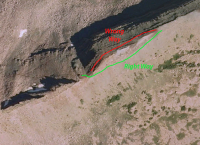
The mishap up on Dead Horse Pass happened because we spent some time hanging out on the ridge and then just took the wrong way around a little knob to get down the pass. It was a faint trail that turned into nothing and eventually got pretty scary. The correct way around that knob is on the south side where the well established trail is. Here's a little diagram:

upload_2014-4-24_11-58-40.png

You can see the Dead Horse Pass switchbacks on the left and the nice flat ridge (great views) on the far right. I doubt most people would make the same mistake that we did. It was just a dumb mistake. I would definitely avoid the north side of that knob at all costs. The views are plenty good on the ridge to the east with plenty of open space to take it in.

This part of the Uintas is so good because of the scenery. It's the most dramatic, alpine scenery in the range, in my opinion. Particularly the West Fork Black's Fork part of this hike. Rock Creek is more typical of the rest of the range but still really nice. The three big drainages between Mirror Lake highway and WFBF are simply the best in the range, IMO (Stillwater, East Fork Bear River & West Fork Black's Fork). Once you go there and stand below the massive glacial cirques at the top of those drainages, you'll know exactly what I mean.
 
Man... thinking about it makes me want to redo this trip this year. Definitely one of my all time favorites.

If you do and are looking for company I'm in. ;) It looks like a great roundup of the best of the Uintas. I think the only thing that could make it better is if you went to Allsop first, then crossed over into Deadhorse, and then went over into Rock Creek. Oh man.... typing that got me excited.
 
The correct way around that knob is on the south side where the well established trail is.

This part of the Uintas is so good because of the scenery. It's the most dramatic, alpine scenery in the range, in my opinion. Particularly the West Fork Black's Fork part of this hike. Rock Creek is more typical of the rest of the range but still really nice. The three big drainages between Mirror Lake highway and WFBF are simply the best in the range, IMO (Stillwater, East Fork Bear River & West Fork Black's Fork). Once you go there and stand below the massive glacial cirques at the top of those drainages, you'll know exactly what I mean.

Thanks for the diagram! I get it now. I anxiously await when I will be able to stand below those mentioned cirques and know what you mean from personal experience.
 
Good times. Thanks for posting this one Nick! Seeing that bad ass pic of my old truck kinda makes me want to cry though. RIP Tacoma.
 
@Smokey! Good to see you around these parts! This one has been up in some form since 2007! Time to put away the skis and start hiking and fishing again? :D
 
I have been looking for a good backpacking/fishing trip to do this summer - probably Labor Day weekend. Couple questions about Dead Horse Lake:
1. How's the fishing, particularly in early September when the bugs aren't quite as thick?
2. I noticed that to get to the trail head there may be a river crossing. I'm driving in a 2WD Mazda CX-7 (small SUV/Crossover). Do you think this would make it? I suppose this may depend on how high the water is flowing, but by September it may not be quite as high right?
3. I did Timothy lakes last 4th of July and LOVED the solitude. How much foot traffic does this hike see?


  • In September, I think you will be ok crossing the river. Worse case is you have to park it and hike a few extra miles.
  • It is pretty area and a fairly popular hike. good chance you will see other people...especially over Labor day weekend.
  • Fishing in september tends to be really good in the Uintas :)
 

Don't like ads? Become a BCP Supporting Member and kiss them all goodbye. Click here for more info.

Back
Top