Uintas Conditions 2019

I am not convinced any cornices would be melted out by father's day, that's only 4 weeks from now. Looking at the weather forecast for the next week it looks like the Uintas are still going to be accumulating snow at least for another week. Lows in Kamas, at around 6k feet are projected to be below freezing for the next week with rain projected every day. In other words deadhorse pass at 12k is going to get a lot more snow still.
 
I am not convinced any cornices would be melted out by father's day, that's only 4 weeks from now. Looking at the weather forecast for the next week it looks like the Uintas are still going to be accumulating snow at least for another week. Lows in Kamas, at around 6k feet are projected to be below freezing for the next week with rain projected every day. In other words deadhorse pass at 12k is going to get a lot more snow still.
VERY anecdotal, but I've seen Rocky Sea majorly/scarily corniced around June 10ish in a previous year - I think it was a more or less average year but I wasnt a skier yet so I didn't pay close attention to such things.

That said, I'm sure, given his background, Art had a different standard for scary than the rest of us without the mountaineering experience. Which likely includes John Q Neighbor. :)
 
That said, I'm sure, given his background, Art had a different standard for scary than the rest of us without the mountaineering experience
Which is why my trip reports here sound like a safety public service announcement: "this section is not for the casual backpacker" "the obstacle is not for the faint of heart" "advanced navigation skills are essential". I am worried of luring someone into something over their head.
 
Yeah...I'm going to predict that Dead Horse and conditions elsewhere in the Uintas are going to be much like it was in 2011 when Eric Robinson tried soloing the Highline and didn't make it, and that was in late July/early August. Granted, his remains were later found above Allsop, but it's theorized that he sought passage via Allsop due to Dead Horse still appearing to be unsurmountable without any mountaineering gear. With more big snows now expected to blanket those high lands through at least the next week to come, on top of what they still already have up there....yeah...going to be a while yet before most of those passes are dry.
 
Yeah...I'm going to predict that Dead Horse and conditions elsewhere in the Uintas are going to be much like it was in 2011 when Eric Robinson tried soloing the Highline and didn't make it, and that was in late July/early August. Granted, his remains were later found above Allsop, but it's theorized that he sought passage via Allsop due to Dead Horse still appearing to be unsurmountable without any mountaineering gear. With more big snows now expected to blanket those high lands through at least the next week to come, on top of what they still already have up there....yeah...going to be a while yet before most of those passes are dry.

Yes, probably, on the passes being snowpacked later than the last few years and more like normal.

Interestingly, I went over that pass, Deadhorse, a couple/three weeks after Eric looking for him the whole way. It was 1/2 dry and not too sketch. Not too sketchy and more snow-free, but again, the sketchiness depends on your experience.

Another interesting tidbit that I have shared somewhere here at BCP - probably in the huge Eric Robinson thread, I went over that ridge (no named pass) between Deadhorse and Allsop and descended a route right near where Eric's body was eventually found. It was "not for the faint of heart" either. No disrespect to him intended but the danger was manageable for me. As i was coming down through cliff bands and into a big talus boulder field I found a horse skeleton with pack saddles and frame pieces still attached. Since I had come over Dead Horse pass to get to that "pass" or ridge to descend I was thinking about the naming and the irony when I encountered the skeleton. I never published that route or TR for the reason that I could not control who would follow it.
 
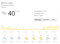
By Chance does anyone know far far you can drive up Mirror Lake Highway at this point?
Read through this whole thread, you will see people's experiences as they encounter them and links to resources that are also posting them. The forest's FB page is particularly active with updates this year. You can drive well past the gate right now from the south but not too Upper Provo Falls and a little past the gate from the north to at least the xmas meadows road turnoff.
 
Judging by all the comments on FB posts about the MLH, there's a ton of people itching to get up there. I can understand the excitement, but at the same time...getting up there right when it opens is also when the mosquitos are going to start coming out in full force...and they will be something vicious this year, I'm sure. Also...that highway and most everything accessible from it up there is getting more and more popular, so much so that mid-week days are now as crowded as weekends used to look like 10 to 20 years ago and getting around up there on the weekends now days is like trying to navigate the crowds at Disneyland.
 
Last edited:
Yes, probably, on the passes being snowpacked later than the last few years and more like normal.

Interestingly, I went over that pass, Deadhorse, a couple/three weeks after Eric looking for him the whole way. It was 1/2 dry and not too sketch. Not too sketchy and more snow-free, but again, the sketchiness depends on your experience.

Another interesting tidbit that I have shared somewhere here at BCP - probably in the huge Eric Robinson thread, I went over that ridge (no named pass) between Deadhorse and Allsop and descended a route right near where Eric's body was eventually found. It was "not for the faint of heart" either. No disrespect to him intended but the danger was manageable for me. As i was coming down through cliff bands and into a big talus boulder field I found a horse skeleton with pack saddles and frame pieces still attached. Since I had come over Dead Horse pass to get to that "pass" or ridge to descend I was thinking about the naming and the irony when I encountered the skeleton. I never published that route or TR for the reason that I could not control who would follow it.
I would love to do a route from Dead Horse to Middle Basin going over all those ridges. I know @Nick and possibly others have done most/all of them and it looks awesome. Combine that with the Highline and some off-trail stuff on the south side of the Crest and you've got a killer loop.
 
Yeah...I'm going to predict that Dead Horse and conditions elsewhere in the Uintas are going to be much like it was in 2011 when Eric Robinson tried soloing the Highline and didn't make it, and that was in late July/early August. Granted, his remains were later found above Allsop, but it's theorized that he sought passage via Allsop due to Dead Horse still appearing to be unsurmountable without any mountaineering gear. With more big snows now expected to blanket those high lands through at least the next week to come, on top of what they still already have up there....yeah...going to be a while yet before most of those passes are dry.

This discussion of Dead Horse has gotten me slightly concerned.
I have Dead Horse Pass on my agenda 2x this summer. 1st mid July, 2nd mid August.
July will be descending the north face, August ascending.

If there is an uncomfortable amount of snow, what is the best way to handle it?
Is there any known "work-around"?

As summer traffic increases I'm certain we'll have regular updates on the area.

For those with more experience than I, are there conditions where I should not
even attempt? Should I seriously be considering different routes?
 
It’s really about your risk tolerance. Mine is not all that high. The thing to keep in mind is in one stretch you are traversing just above a cliff area with a very short area to self arrest. Cornice near the top would be a deal breaker for me. Younger more risk tolerant folks might still try it.

As far as alternates your options are very limited. You would either have to head north out West Fork Blacks Fork and attempt to cross over into Rock Creek basin from the Priord Lake area. No official trail there.

The only other real option would be to drop south and cross Cleveland Pass. Probably adding a full day.


Sent from my iPhone using Tapatalk
 
I believe that @regher scouted the crossing into Rock Creek basin from Priod last summer. Maybe he can provide some insights.

Sure wish there was a real route there.


Sent from my iPhone using Tapatalk
 
If Dead Horse is bad, then any off-trail crossing will certainly be worse. But you can assess conditions when you get to the top of Red Knob, as it's also somewhat steep.and north-facing, and Dead Horse is clearly visible from the top.

Cleveland Pass is definitely the play if you need to re-route. It will be snow-free by August, easily.
 
This discussion of Dead Horse has gotten me slightly concerned.
I have Dead Horse Pass on my agenda 2x this summer. 1st mid July, 2nd mid August.
July will be descending the north face, August ascending.

If there is an uncomfortable amount of snow, what is the best way to handle it?
Is there any known "work-around"?

As summer traffic increases I'm certain we'll have regular updates on the area.

For those with more experience than I, are there conditions where I should not
even attempt? Should I seriously be considering different routes?

Too tough to transfer to you a mountaineer's skills and experience over the intertubes. For you and all here that aspire to do this stuff it is a great idea to have some skills in your toolbox. I highly recommend that you schedule a winter mountaineering or snow safety class. I have seen such and attended ones at the UofU years ago. You probably have enough time ahead of time and the skills last forever. Just like taking motorcycle safety foundation classes and getting some race track time will help your round town and highway motorcycle skills having self arrest, snow climbing and snow assessment skills will help you any time you face a situation.

That said no one can predict what you will see when you get there and whether it is at your comfort level.

Some tips:
- ascending is always easier than descending - you can assess the situation before you get into the crux and you don't have cornice overhangs blocking your view
- you can always turn around - if it is sketch fall back to turning around and following your contingency plan. You have one don't you?
- always have a contingency plan if you can't finish to your objective
- have an ice axe with you - really though, know how to use it. See training in previous paragraph.
- crampons are of marginal use in snow soft enough to kick steps - they are for when it is hard packed or ice
- ice axe is more important than crampons more often and modern ultralight axes only weigh 13 oz or less
- if there are more than one of you than proceed one at a time through the crux or on the fall line if there is avalanche risk - you need someone there to rescue you and your stuff
- Buy some reading material and start learning about the techniques and skills. I cut my teeth on Mountaineering: Freedom of the Hills: https://www.amazon.com/dp/1594851387/?tag=backcountrypo-20
 
Last edited:
Update from US Forest Service:
Evanston Ranger District update on area around Bear River Ranger Station. The area around Bear River is clear of snow. You can get to Christmas Meadows trailhead, but the trailhead parking and trail are extremely wet and muddy and can only hike about a 1.5 miles then knee deep snow. Can drive on the Mirror Lake Highway to Sulphur campground, (which is not open due to a snow drift), and then the highway is closed due to snow. Some people made it to Lily Lake last weekend, but had to use 4 wheel drive. The Lily Lake dump station is still closed.
 
1559249221387.png
It's going to stay at or above freezing up high over the next week, fortunately. Should start thawing out a lot faster than it has been recently at least!
 
Has anyone heard any noises about flooding? This to me seems a lot like the 83 winter... big snow year with very late melt, so it goes really fast. But I'm an amateur on the internet.
 
this is more Wasatch-specific but the info can likely be adapted for Uintas:
Very interesting. Looks like we're in for some very significant runoff. I frequently run at a park centered on Little Cottonwood Creek. A few days ago, one of the neighborhoods I run through to get there had a few pallets of sandbags on the street for the houses along the creek itself. So it seems like they're planning for a good sized flood.
 
Not the Uintas, but I went up AF canyon last night and there is still a ridiculous amount of snow in the mountains. Last year at this time I was hiking up to Silver Lake without any snow, judging from what I could see last night, there is probably at least 5 feet of snow at that elevation this year.

Hiking along the benches a few days ago and there were more wildflowers out than I can ever remember seeing before. Should be a beautiful summer once we can get up there.
 
Similar threads
Thread starter Title Forum Replies Date
Upgrayedd Uintas Conditions 2023 Trip Planning 39
2eez4life Uintas Conditions 2022 Trip Planning 18
Upgrayedd Uintas Conditions 2021 Trip Planning 9
Upgrayedd Uintas Conditions 2020 Trip Planning 69
Dave Uintas Conditions 2018 General Discussion 210
Dave Uintas Conditions 2017 General Discussion 128
Jackson Uintas Conditions 2016 General Discussion 93
Vegan.Hiker Wasatch/Uintas conditions late April/early May Trip Planning 6
Upgrayedd Starting a fire in damp conditions in the Uintas General Discussion 14
Nick Uintas Conditions 2015 General Discussion 212
Udink Uintas Conditions 2014 Trip Planning 219
MtnMatt Uintas conditions?? Trip Planning 9
MtnMatt current conditions in the Uintas General Discussion 1
Nick Uintas Conditions 2013 General Discussion 115
Tarp Boy Looking for Shuttle service for Uintas Granddaddy basin trip Trip Planning 0
2eez4life Suggestions: Uintas Backpacking with some rock climbing routes Trip Planning 0
regehr (Uintas) Lake Fork Fun Backpacking 8
scatman Reid's Peak - Uintas - July 22, 2023 Hiking & Camping 6
NorthwestWanderer First time in the High Uintas | Red Castle SNEAK Loop | I give these mountains 5 out of 5 stars Backpacking 7
regehr Uintas this weekend? Trip Planning 4
2eez4life 4 days 3 nights in the Uintas Trip Planning 9
6 Uintas Trip Planning Trip Planning 5
Perry Sunrise/Sunset Uintas Marriage Proposal Location Suggestions Trip Planning 25
N Gilbert Meadows- High Uintas Trip Planning 0
WasatchWill The High Uintas 4-4-4: Four Basins, Four Passes, Four Days Backpacking 20
C High Uintas Wilderness - Last minute plans Trip Planning 4
Mountain Wanderer High Uintas Wilderness - Granddaddy Basin Backpacking 4
scatman Bourbon Lake, Uintas - July 11, 2020 Hiking & Camping 4
ridings82 Uintas Backpacking Loop Trip Reports 12
B Uintas question Hiking & Camping 3
Tarp Boy Uintas in late June? Trip Planning 10
Born to Hike Mountain Solitude: Reconnaissance Lake, High Uintas, early Sept 2019 Backpacking 9
Ehouston24 Uintas Loop (Red Castle/Kings Peak) Trip Planning 14
DrNed Plan B to High Uintas Backpacking Trip Planning 20
DrNed Recommendation for 35-45 Mile Route in the Uintas Trip Planning 7
Yvonne A weekend in the Uintas Hiking & Camping 10
WasatchWill 5 Guys on a Trail: A Tour of the Southwestern Uintas Backpacking 12
wabenho Rainbow Lake, Uintas - September 2018 Backpacking 6
DesertRatShorty Solitude in the Uintas -- Gilbert Lake Loop Backpacking 14
jdfut66 Uintas - Priord Lake to Deadhorse Lake Loop Backpacking 6
Born to Hike Clements Lake and East Basin in the High Uintas, mid-July 2018 Backpacking 6
TrektheWorld Need help with Uintas trip - camping Trip Planning 8
Perry Missing hiker in Uintas - Ray Humpherys General Discussion 104
Mike K Uintas Three Nighter Backpacking 13
LarryBoy In Which I Forget Sunscreen (Uintas 2015) Backpacking 11
Brian Handsaker Uintas Backpacking (or Montana) Trip Planning 9
Uncle_Dim October in the Uintas Trip Planning 2
Perry Late Season Uintas Day Hike Ideas. Bear River to WFBF and Back? Trip Planning 13
r3biker Backpacking trip to Clyde lake in Uintas Backpacking 8
WasatchWill An Intro to the Uintas Hiking & Camping 2

Similar threads

Back
Top