- Joined
- Dec 23, 2013
- Messages
- 4,502
After hiking 20+ miles two days earlier along the Mary Mountain Trail, @Joey , @Keith and @Keith R. were sporting enough to join @McGimpkins and myself for a 22 miler through the southern end of Hayden Valley, up to Mary Lake and then north to Cygnet Lakes before exiting the backcountry at the Cygnet Lakes Trailhead. I had completed this hike seven years earlier and wanted to go back and get a more precise route from Mary Lake to Cygnet Lakes on the now defunct Plateau Trail.
While driving into the Park, we had strategically placed @McGimpkin's truck at the Cygnet Lakes Trailhead for our shuttle vehicle.
Well, as you can imagine everyone was all smiles as we awoke at 4:30 am at the Bridge Bay Campground to get ready to go. After getting all of our gear ready, we set off for Hayden Valley and Trout Creek. We parked our vehicles at the turnout just south of where Trout Creek flows under the Grand Loop Road and were on the trail by 5:36 am.

Starting before sunrise
Our approach would be to follow the old stagecoach route along Trout Creek through the southern end of Hayden Valley and intersect with the Mary Mountain Trail a couple of miles from Mary Lake. This route would take us past the old Trout Creek Garbage Dump, the hill where the Craigheads' conducted a vast majority of their Grizzly Bear research in the 60's and by Larry's Lunch Counter where the stagecoaches would stop so that their passengers could have lunch as they passed from the west side of the Park to the east side. Also, we would take some time to explore the thermal features along Alum Creek known as Glen Africa's Basin.

Quite chilly at the start even though @Keith is wearing a short sleeved shirt
Twenty six minutes after beginning our hike, Joey spotted a grizzly sow with two cubs to the south of us. She is aware of us and is running towards the west with the two cubs in tow. Occasionally, she will rise up on two legs to get a better look at us and determine exactly what we are.

@Joey checking out the sow with two cubs
Well of course this has everyone in our group pretty excited as we continued on. @Keith notices as we cross under some power poles that one of the poles has something on it and he goes to investigate what it might be. It turns out that it is some kind of temperature gauge. @Keith, please fill in the details.

@Joey on the old stagecoach road

The two Keiths and McGimpkins checking out the mysterious metal box on the telephone pole
Next up for us was the old garbage dump, where we took a small amount of time to explore on our way west.

A portion of the old garbage dump along Trout Creek in Hayden Valley

The Trout Creek Garbage Dump (still active) in 1969. You can actually see the grizzly trails radiating into it as they made their way to feed on the Park refuse that was hauled there.
After leaving the dump site, we noticed six or seven bison in front of us that took off on a dead run as if they had been shot out of a cannon! We contemplated whether it was us or something else that might have spooked them into such a hurry. Perhaps wolves were on the prowl! As we made our way along the top of a small drainage basin, we could see the culprit - a grizzly bear. He didn't seem to notice us as he made his way around the opposite side of the basin. At one point, an elk came over the hill to the north of us and started down into the basin obviously without seeing the bear. The grizzly proceeded to turn and like lightning began to chase the elk down. It was right on the elk's haunches for a good distance before giving up the chase. I suspect he may have gotten wind of us observing the whole encounter. I have to say that this was the most awe inspiring event that I have witnessed in the backcountry in my 27 years of hiking/backpacking. What a treat to witness.

The old road leaving the garbage dump

The grizzly before the chase ensued. Note you have a bear, biosn and elk all in the same shot. Photo courtesy of McGimpkins
Well if that doesn't get the blood pumping then nothing will. Just over an hour into our hike and already four grizzlies.
We continued along the road, with beautiful views of Hayden Valley unfolding before us, crossed Trout Creek and the next unnamed drainage before taking a break.

Elephant heads in bloom in Hayden Valley

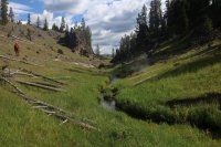
@Keith R. crossing Trout Creek in stride

Southern portion of Hayden Valley

@Joey making his way through Hayden Valley

@Keith standing on an old bridge abutment over an unnamed drainage. We took a break in the trees ahead
After break, we continued to walk in the bed of the old stagecoach road as it makes its way along the tree line on the southern end of the valley. Along the way, we run into many bull bison that seem to be curious as to why humans are back in these parts. Eventually, we reach Alum Creek where we took a detour north along the creek to Glen Africa Basin.

Hiking along the old stagecoach road with Hayden Valley stretching out to the west

A good shot of the old road bed cut into the hillside

Hiking along the road. Mary Mountain in the distance can be seen just above @Keith 's head

Mary Mountain

Bison along our way

A lone bull

Approaching Alum Creek

The old bridge abutment at Alum Creek
We headed north along the creek through a small canyon to reach the basin. The short distance through the canyon was littered with elk bones and antlers along with small thermal features. Once the canyon opened up into Hayden Valley again we found ourselves at Glen Africa's Basin where we took our second break of the day. The basin has a couple of nice thermal hot springs that we checked out before returning to the road and on to the Mary Mountain Trail.

Heading north along Alum Creek towards Glen Africa Basin

Customary shot with the elk skull and antlers. Neither of us are smiling @Bob

Thermal feature in Glen Africa Basin

Thermal feature in Glen Africa Basin
After Alum Creek, the old roads begins a small 0.9 mile climb before intersecting with the Mary Mountain Trail. Once on the Mary Mountain Trail, it is an easy two mile hike to Mary Lake and the patrol cabin located there where we stopped to eat lunch and refill our water bottles.

Straddling the old stagecoach road. My feet are in the left and right ruts or perhaps I'm about to relieve myself.")

The Mary Mountain Trail (aka the Buffalo Highway)

The wrecking crew at the Mary Mountain Patrol Cabin

A tribute? I think from @Joey
I might add that the privy at this patrol cabin is top of the line. If you ever visit the cabin, you have to check out the outhouse.
After lunch, we had to backtrack a short distance to pick up the old trail to Cygnet Lakes. The first part of this abandoned trail is in pretty good condition and is an extremely pleasant walk through the woods. @Keith and I were taking GPS points of all of the trail markers that we could find along the entire length of the old trail. With the excellent help of everyone pointing out markers, I believe that between the two of us we probably recorded locations for all the markers that were visible between the lakes.
The first mile of the trail from Mary Lake is relatively easy hiking. The second mile is still rather straight forward but there is more stepping over downfall to contend with but the trail is obvious and still well marked. Between miles two and three is where the trail becomes difficult to stay on at times. At this point the old trail skirted a burn area as we made our way uphill onto the highest part of the Central Plateau. At the 2.5 mile mark the trail heads directly into full burn for a mile. Seven years ago, this section was not too bad as the downfall was less and the new growth more forgiving as we stayed on the trail. This time was much more difficult but we managed to stay on the old trail within reason. Once out of the burn, the trail is easy to follow again up until about a quarter mile from the Cygnet Lakes meadows where we ran into the last trail marker. At this point, we followed sewn logs which ended up deviating slightly from where the original trail is located on the old USGS 15 minute maps. I assume after the 1988 fires someone (Park Service?) cut the trail to the meadows south of the original route so as not to contend with the burn and to keep people from still using the now abandoned trail if hiking into Cygnet Lakes from the Cygnet Lakes Trail. Of course I could be totally wrong but it seems reasonable form what we saw on the ground.

The old Plateau Trail between Mary Lake and Cygnet Lakes

@McGimpkins on the trail

Pleasant hiking

Starting to get a little hairy. Notice the trail marker on a tree north of @Keith

Getting more challenging

About to become unbearable!

An old trail marker (flush against the tree) and an "I" Blaze that preceded it

Map of the route between the lakes. All dots on the map are recorded waypoints. The pink line at the top center of the map is the location of the original trail on the old USGS 15 minute map. as you can see the points end at the meadow just south of the pink line. The trail could not be discerned today where the pink line is located.
Once out into the meadows (marsh) that surround Cygnet Lakes, we hiked the last four miles out along the maintained Cygnet Lakes Trail back to the trailhead. While this trail winds through burn, we did get an excellent view down into the headwaters of Otter Creek along with passing a few unnamed ponds.

Cygnet Lakes in the distance and the marshes that surround them

The Cygnet Lakes Trail. Observation Peak in the distance with storm clouds moving in.

The headwaters of Otter Creek

The backcountry information sign at the Cygnet Lakes Trailhead
If you have a full day to kill in Yellowstone then this hike might be for you. The hike through Hayden Valley and up to Mary Lake is definitely a must. The portion to Cygnet Lakes should be done with at least 3 or 4 people just to make sure you are able to keep to the trail and for bear safety concerns. It is possible to skirt the completely burned area and come back to the trail where the going is easier.
Thanks to my hiking partners who made this trip possible and certainly more enjoyable.
While driving into the Park, we had strategically placed @McGimpkin's truck at the Cygnet Lakes Trailhead for our shuttle vehicle.
Well, as you can imagine everyone was all smiles as we awoke at 4:30 am at the Bridge Bay Campground to get ready to go. After getting all of our gear ready, we set off for Hayden Valley and Trout Creek. We parked our vehicles at the turnout just south of where Trout Creek flows under the Grand Loop Road and were on the trail by 5:36 am.
Starting before sunrise
Our approach would be to follow the old stagecoach route along Trout Creek through the southern end of Hayden Valley and intersect with the Mary Mountain Trail a couple of miles from Mary Lake. This route would take us past the old Trout Creek Garbage Dump, the hill where the Craigheads' conducted a vast majority of their Grizzly Bear research in the 60's and by Larry's Lunch Counter where the stagecoaches would stop so that their passengers could have lunch as they passed from the west side of the Park to the east side. Also, we would take some time to explore the thermal features along Alum Creek known as Glen Africa's Basin.
Quite chilly at the start even though @Keith is wearing a short sleeved shirt
Twenty six minutes after beginning our hike, Joey spotted a grizzly sow with two cubs to the south of us. She is aware of us and is running towards the west with the two cubs in tow. Occasionally, she will rise up on two legs to get a better look at us and determine exactly what we are.
@Joey checking out the sow with two cubs
Well of course this has everyone in our group pretty excited as we continued on. @Keith notices as we cross under some power poles that one of the poles has something on it and he goes to investigate what it might be. It turns out that it is some kind of temperature gauge. @Keith, please fill in the details.
@Joey on the old stagecoach road
The two Keiths and McGimpkins checking out the mysterious metal box on the telephone pole
Next up for us was the old garbage dump, where we took a small amount of time to explore on our way west.
A portion of the old garbage dump along Trout Creek in Hayden Valley
The Trout Creek Garbage Dump (still active) in 1969. You can actually see the grizzly trails radiating into it as they made their way to feed on the Park refuse that was hauled there.
After leaving the dump site, we noticed six or seven bison in front of us that took off on a dead run as if they had been shot out of a cannon! We contemplated whether it was us or something else that might have spooked them into such a hurry. Perhaps wolves were on the prowl! As we made our way along the top of a small drainage basin, we could see the culprit - a grizzly bear. He didn't seem to notice us as he made his way around the opposite side of the basin. At one point, an elk came over the hill to the north of us and started down into the basin obviously without seeing the bear. The grizzly proceeded to turn and like lightning began to chase the elk down. It was right on the elk's haunches for a good distance before giving up the chase. I suspect he may have gotten wind of us observing the whole encounter. I have to say that this was the most awe inspiring event that I have witnessed in the backcountry in my 27 years of hiking/backpacking. What a treat to witness.
The old road leaving the garbage dump
The grizzly before the chase ensued. Note you have a bear, biosn and elk all in the same shot. Photo courtesy of McGimpkins
Well if that doesn't get the blood pumping then nothing will. Just over an hour into our hike and already four grizzlies.
We continued along the road, with beautiful views of Hayden Valley unfolding before us, crossed Trout Creek and the next unnamed drainage before taking a break.
Elephant heads in bloom in Hayden Valley
@Keith R. crossing Trout Creek in stride
Southern portion of Hayden Valley
@Joey making his way through Hayden Valley
@Keith standing on an old bridge abutment over an unnamed drainage. We took a break in the trees ahead
After break, we continued to walk in the bed of the old stagecoach road as it makes its way along the tree line on the southern end of the valley. Along the way, we run into many bull bison that seem to be curious as to why humans are back in these parts. Eventually, we reach Alum Creek where we took a detour north along the creek to Glen Africa Basin.
Hiking along the old stagecoach road with Hayden Valley stretching out to the west
A good shot of the old road bed cut into the hillside
Hiking along the road. Mary Mountain in the distance can be seen just above @Keith 's head
Mary Mountain
Bison along our way
A lone bull
Approaching Alum Creek
The old bridge abutment at Alum Creek
We headed north along the creek through a small canyon to reach the basin. The short distance through the canyon was littered with elk bones and antlers along with small thermal features. Once the canyon opened up into Hayden Valley again we found ourselves at Glen Africa's Basin where we took our second break of the day. The basin has a couple of nice thermal hot springs that we checked out before returning to the road and on to the Mary Mountain Trail.
Heading north along Alum Creek towards Glen Africa Basin
Customary shot with the elk skull and antlers. Neither of us are smiling @Bob
Thermal feature in Glen Africa Basin
Thermal feature in Glen Africa Basin
After Alum Creek, the old roads begins a small 0.9 mile climb before intersecting with the Mary Mountain Trail. Once on the Mary Mountain Trail, it is an easy two mile hike to Mary Lake and the patrol cabin located there where we stopped to eat lunch and refill our water bottles.
Straddling the old stagecoach road. My feet are in the left and right ruts or perhaps I'm about to relieve myself.
The Mary Mountain Trail (aka the Buffalo Highway)
The wrecking crew at the Mary Mountain Patrol Cabin
A tribute? I think from @Joey
I might add that the privy at this patrol cabin is top of the line. If you ever visit the cabin, you have to check out the outhouse.
After lunch, we had to backtrack a short distance to pick up the old trail to Cygnet Lakes. The first part of this abandoned trail is in pretty good condition and is an extremely pleasant walk through the woods. @Keith and I were taking GPS points of all of the trail markers that we could find along the entire length of the old trail. With the excellent help of everyone pointing out markers, I believe that between the two of us we probably recorded locations for all the markers that were visible between the lakes.
The first mile of the trail from Mary Lake is relatively easy hiking. The second mile is still rather straight forward but there is more stepping over downfall to contend with but the trail is obvious and still well marked. Between miles two and three is where the trail becomes difficult to stay on at times. At this point the old trail skirted a burn area as we made our way uphill onto the highest part of the Central Plateau. At the 2.5 mile mark the trail heads directly into full burn for a mile. Seven years ago, this section was not too bad as the downfall was less and the new growth more forgiving as we stayed on the trail. This time was much more difficult but we managed to stay on the old trail within reason. Once out of the burn, the trail is easy to follow again up until about a quarter mile from the Cygnet Lakes meadows where we ran into the last trail marker. At this point, we followed sewn logs which ended up deviating slightly from where the original trail is located on the old USGS 15 minute maps. I assume after the 1988 fires someone (Park Service?) cut the trail to the meadows south of the original route so as not to contend with the burn and to keep people from still using the now abandoned trail if hiking into Cygnet Lakes from the Cygnet Lakes Trail. Of course I could be totally wrong but it seems reasonable form what we saw on the ground.
The old Plateau Trail between Mary Lake and Cygnet Lakes
@McGimpkins on the trail
Pleasant hiking
Starting to get a little hairy. Notice the trail marker on a tree north of @Keith
Getting more challenging
About to become unbearable!
An old trail marker (flush against the tree) and an "I" Blaze that preceded it
Map of the route between the lakes. All dots on the map are recorded waypoints. The pink line at the top center of the map is the location of the original trail on the old USGS 15 minute map. as you can see the points end at the meadow just south of the pink line. The trail could not be discerned today where the pink line is located.
Once out into the meadows (marsh) that surround Cygnet Lakes, we hiked the last four miles out along the maintained Cygnet Lakes Trail back to the trailhead. While this trail winds through burn, we did get an excellent view down into the headwaters of Otter Creek along with passing a few unnamed ponds.
Cygnet Lakes in the distance and the marshes that surround them
The Cygnet Lakes Trail. Observation Peak in the distance with storm clouds moving in.
The headwaters of Otter Creek
The backcountry information sign at the Cygnet Lakes Trailhead
If you have a full day to kill in Yellowstone then this hike might be for you. The hike through Hayden Valley and up to Mary Lake is definitely a must. The portion to Cygnet Lakes should be done with at least 3 or 4 people just to make sure you are able to keep to the trail and for bear safety concerns. It is possible to skirt the completely burned area and come back to the trail where the going is easier.
Thanks to my hiking partners who made this trip possible and certainly more enjoyable.