I had a plan.
Drive to a remote mission in Baja, leave a minibike there, drive to another remote mission, hike the El Camino Real back to the minibike and then ride the minibike back to the car.
I might as well have had said, "Here, hold my beer."
You can read about it here.
Nothing against the plan, but if one part fails, it all fails.
The odds were against me from the beginning on making this happen and I should have postponed it another year, but there were compelling reasons to go this year.
Why this year? Age and failing body. My hiking days are numbered and my prime years of carrying heavy packs long distances over rough terrain ended a decade ago. Every year that passed meant that the odds of this happening were quickly dropping.
Problems with doing it this year were numerous.
Baja was in midst of multi-year drought, water sources were drying up and livestock was dying in large numbers in the area. An area with reliable water on the route was reported to being used by Narco's and it wasn't safe to pass through.
Then I caught COVID, not quite life threatening, but it did require a short hospital stay. After recovering from that I had no stamina. Looking back 9 months later, I was in no shape to be trying to hike this.
Finally, logistics, I had a shuttle ride lined up for the initial plan. Then when I got sick I had to cancel the original trip and instead of going in December I ended up going in February and now I had no shuttle ride.
With a new plan and a new date, I headed out early one morning in February and headed south from my home in Northern California. I prefer to cross the border at Mexicali. While it is shorter and perhaps a couple of hours quicker to go to San Diego and cross at Tijuana it has its own drawbacks. I would not be able to camp along the way before crossing the border. I would have to deal with LA's and San Diego's traffic. Plus, it is a lot less hectic driving through Mexicali than through Tijuana. Then there is the fact that there are no toll roads to deal with when crossing at Mexicali.
Some rain had passed through southern California recently and the Tehachapi's were green.

I spent the first night at a campground on the Salton Sea.

Up early on the second day and I head to Calexico where I pick up some last minute supplies and exchange some USD for Pesos. I know I can exchange money on the other side of the border at a Casa de Cambio or pay with Dollars at a Pemex station and get Pesos in change, but for convenience I will exchange in the US. On a side note, you can get good exchange rates by paying in Dollars at the Pemex station.

They had changed the border crossing at Mexicali since my last visit and it caught me off guard. Even worse there was some road changes in Mexicali and I made a couple of wrong turns resulting in a delay getting out of town.
San Felipe has tripled in size since the 1990's and while it tries to hold on to its small fishing town vibe, it is not.
After leaving San Felipe as I was heading south towards Puertecitos I spent lot of time reflecting on past trips. Is this what old people do? I was thinking about my first trip in 1992 and how it felt like such an adventure. I thought about all the trips with my, now deceased, wife and our children that we had made over the years. I thought about how much has changed since then.
The road to Puertecitos is marginally better now than the road I was on in 1992. When we arrived in town on that first trip on motorcycles 30 years ago we did not know if we could get gas in town or not. We were under the impression that there would be no gas station for quite a distance south of Puertecitos.
We pulled up to the gas tanks in town and there was no one around, we had to go find someone who had a key to unlock the tanks, so we could fill up the bikes.
Today there is a real, regular gas station in town and the road south of Puertecitos is no longer dirt.
What used to take a day of travel between Puertecitos and Highway 1, now only takes hours. It is paved with turn outs and overlooks, gas stations and restaurants, cars and semi's. It also now has graffiti and crime, gone is Coco of Coco's Corner.
Old road south of Puertecitos


The New Road
Enough reminiscing, I drive past Puertecitos, past Papa Fernandez's and Alfonsina's, Past Gonzaga Bay and the NEW Coco's Corner, and before I realize it I am at Highway 1. Turning left I head further south to the Bay of LA turnoff. 40 miles or so later I reach the turn off to San Borja, the northern mission I hope to hike to.
The road to San Borja is rough for the Subaru but I finally make it on the afternoon of my second day. A family member comes out, I was hoping for one of the kids because they speak at least some English.
I should make it clear now, I do not speak Spanish. Even though I have spent many months in Mexico my Spanish is limited to a handful of words and short phrases. I want to, believe me, I just do not have an ear for language.
Well, that did not go as planned.
At the mission I get back in my car and with the minibike still in the back I head back out to the highway. Maybe he misunderstood me, maybe he thought I wanted to ride my motorcycle on the ECR, maybe he just didn't want me or the minibike there. Without permission to leave the bike there my plan for a mission-to-mission hike was off.
It is now evening and as I drive back out to the highway, I am looking for a place to camp and deciding on what I can do to salvage the hike and this trip.
The next morning, the start of my third day, I pack up and continue on the dirt road out of Mission San Borja with a modified plan. But before that, as I get close to the highway the car breaks down. It is idling really high and there is no response to the accelerator pedal, just a constant high idle. I turn it off and back on hoping that will fix it. That should show what type of mechanic I am.
Well, that didn't fix it. There is a check engine light on now, so I hook up the code scanner and take note of the code. I clear the code and restart the car and it is working fine. What a relief, but I am worried about what that code was and what had happened.
A BAD PLACE TO BREAK DOWN

Upon reaching the highway I head back towards Highway 1 with a new plan. I will find a spot to access the ECR between the two missions and do a multiday out and back hike. As I go to slow down approaching the junction the car acts up again. Clearing the code resolves it again, but now I need to decide what to do. Continue on and hope whatever is going on does not get any worse or head back to the States to fix the problem?
I decide to head to Guerro Negro where I should be able to get WiFi to see what is going on with the car. Driving south through the small towns and military check points I seem to find a pattern to the car problems, it almost always acts up when accelerating through a certain point in the throttle and when I get WiFi I am able to clarify the problem.
It is the throttle pedal sensor, and it seems to have a bad spot and if I can avoid that section, it will work fine and clearing the codes will reset it, so I decide to continue on. After getting lunch and fuel in Guerro Negro I am off to find the turn off to El Arco.
Following the Highway looking for my turnoff I notice that traffic is very light. It seems that high prices for gasoline and the lingering effects of the pandemic have curtailed traffic in Baja.
The turn off to El Arco leads one to a very long and straight dirt road that is built up 10 feet or so above the surrounding desert with nary a turn for 15 miles and old tires are used as safety cones, highlighting road hazards.


I pass through El Arco, past the turn off to Mission Santa Gertrudis, where my original starting point was, and on to the turnoff to Rancho La Union. I am now driving on a section of the El Camino Real. Passing the Rancho I start looking for a camping spot with access to the ECR and find it down in a wash.

I set up camp for the night and prepare the backpack for an early start tomorrow. I plan on not having any water along this section and that means I am carrying enough water for the next three days.
Up early on day four it is quite chilly for Baja, 29 degrees.
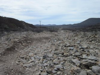
 Today the ECR in Baja is a mixture of paved roads, dirt roads, trails and washes.
One reason I wanted to hike this section was there are no paved roads and just short sections of well-traveled dirt roads. The rest is lightly used dirt roads, washes and trails.
After a quick breakfast I am off. It was perfect weather for hiking, cool with some cloud cover. While Baja is still in a drought a storm had passed through recently bringing life to the desert. The plants were leafing out and the flowers were blooming.
Cirio or Bojuum framing a Cardon.

Elephant Tree

Thorns, Everywhere there are thorns.


There were also lots of flowers blooming and some were quite small.


I do not what these are, but I really liked them.


Cat scratches, not sure if these were made by a good size Bobcat or a small Mountain Lion but they looked pretty fresh.

Based on the size of these, this is a Mountain Lion, I followed these tracks for a half mile down a wash,

Taking a break along the historic El Camino Real in Baja

Weather of the nearby Pacific Ocean kept it cool.

You can see a fogbank at the coast and the day before I had hiked from the well-defined peak in the background a little right of my shadow to here.

For years now the drought was taking its toll in the area.

There must have been a good water source here before the drought, you can see 4 dead cows here and there was several others in the immediate area

Remnants of people out in the desert abounds.
Here are some rock walls near a pass between two drainages near a historic water source that is currently dry.

No idea what this is, some folks have it labeled as a Kiln. It is on the edge of a large arroyo and probably a 1/4 mile away from any road. It is about 6 feet across and 3 or 4 feet deep.

Old trough out in the desert.

My car is parked near the base of the mountains off in the distance, right of center.

I covered 35 miles in the three days, and it was a great hike and I want to go back and continue on from where I turned around.
The rest of my time in Baja was spent at Las Animas finding evidence of the past. Old trails, sleeping circles, and hunting blinds.
I spent time riding my CT70 around and exploring north of the bay at Las Animas.


One night I was lulled to sleep by a lone donkey braying into the night and on another night, I was startled awake by a coyote 'barking' at me which was a little nerve wracking for me since once while camped near that same spot a coyote bit me on the head while I was sleeping.
Then it was time to head back home.
Drive to a remote mission in Baja, leave a minibike there, drive to another remote mission, hike the El Camino Real back to the minibike and then ride the minibike back to the car.
I might as well have had said, "Here, hold my beer."
You can read about it here.
Nothing against the plan, but if one part fails, it all fails.
The odds were against me from the beginning on making this happen and I should have postponed it another year, but there were compelling reasons to go this year.
Why this year? Age and failing body. My hiking days are numbered and my prime years of carrying heavy packs long distances over rough terrain ended a decade ago. Every year that passed meant that the odds of this happening were quickly dropping.
Problems with doing it this year were numerous.
Baja was in midst of multi-year drought, water sources were drying up and livestock was dying in large numbers in the area. An area with reliable water on the route was reported to being used by Narco's and it wasn't safe to pass through.
Then I caught COVID, not quite life threatening, but it did require a short hospital stay. After recovering from that I had no stamina. Looking back 9 months later, I was in no shape to be trying to hike this.
Finally, logistics, I had a shuttle ride lined up for the initial plan. Then when I got sick I had to cancel the original trip and instead of going in December I ended up going in February and now I had no shuttle ride.
With a new plan and a new date, I headed out early one morning in February and headed south from my home in Northern California. I prefer to cross the border at Mexicali. While it is shorter and perhaps a couple of hours quicker to go to San Diego and cross at Tijuana it has its own drawbacks. I would not be able to camp along the way before crossing the border. I would have to deal with LA's and San Diego's traffic. Plus, it is a lot less hectic driving through Mexicali than through Tijuana. Then there is the fact that there are no toll roads to deal with when crossing at Mexicali.
Some rain had passed through southern California recently and the Tehachapi's were green.
I spent the first night at a campground on the Salton Sea.
Up early on the second day and I head to Calexico where I pick up some last minute supplies and exchange some USD for Pesos. I know I can exchange money on the other side of the border at a Casa de Cambio or pay with Dollars at a Pemex station and get Pesos in change, but for convenience I will exchange in the US. On a side note, you can get good exchange rates by paying in Dollars at the Pemex station.
They had changed the border crossing at Mexicali since my last visit and it caught me off guard. Even worse there was some road changes in Mexicali and I made a couple of wrong turns resulting in a delay getting out of town.
San Felipe has tripled in size since the 1990's and while it tries to hold on to its small fishing town vibe, it is not.
After leaving San Felipe as I was heading south towards Puertecitos I spent lot of time reflecting on past trips. Is this what old people do? I was thinking about my first trip in 1992 and how it felt like such an adventure. I thought about all the trips with my, now deceased, wife and our children that we had made over the years. I thought about how much has changed since then.
The road to Puertecitos is marginally better now than the road I was on in 1992. When we arrived in town on that first trip on motorcycles 30 years ago we did not know if we could get gas in town or not. We were under the impression that there would be no gas station for quite a distance south of Puertecitos.
We pulled up to the gas tanks in town and there was no one around, we had to go find someone who had a key to unlock the tanks, so we could fill up the bikes.
Today there is a real, regular gas station in town and the road south of Puertecitos is no longer dirt.
What used to take a day of travel between Puertecitos and Highway 1, now only takes hours. It is paved with turn outs and overlooks, gas stations and restaurants, cars and semi's. It also now has graffiti and crime, gone is Coco of Coco's Corner.
Old road south of Puertecitos
The New Road
Enough reminiscing, I drive past Puertecitos, past Papa Fernandez's and Alfonsina's, Past Gonzaga Bay and the NEW Coco's Corner, and before I realize it I am at Highway 1. Turning left I head further south to the Bay of LA turnoff. 40 miles or so later I reach the turn off to San Borja, the northern mission I hope to hike to.
The road to San Borja is rough for the Subaru but I finally make it on the afternoon of my second day. A family member comes out, I was hoping for one of the kids because they speak at least some English.
I should make it clear now, I do not speak Spanish. Even though I have spent many months in Mexico my Spanish is limited to a handful of words and short phrases. I want to, believe me, I just do not have an ear for language.
Well, that did not go as planned.
At the mission I get back in my car and with the minibike still in the back I head back out to the highway. Maybe he misunderstood me, maybe he thought I wanted to ride my motorcycle on the ECR, maybe he just didn't want me or the minibike there. Without permission to leave the bike there my plan for a mission-to-mission hike was off.
It is now evening and as I drive back out to the highway, I am looking for a place to camp and deciding on what I can do to salvage the hike and this trip.
The next morning, the start of my third day, I pack up and continue on the dirt road out of Mission San Borja with a modified plan. But before that, as I get close to the highway the car breaks down. It is idling really high and there is no response to the accelerator pedal, just a constant high idle. I turn it off and back on hoping that will fix it. That should show what type of mechanic I am.
Well, that didn't fix it. There is a check engine light on now, so I hook up the code scanner and take note of the code. I clear the code and restart the car and it is working fine. What a relief, but I am worried about what that code was and what had happened.
A BAD PLACE TO BREAK DOWN
Upon reaching the highway I head back towards Highway 1 with a new plan. I will find a spot to access the ECR between the two missions and do a multiday out and back hike. As I go to slow down approaching the junction the car acts up again. Clearing the code resolves it again, but now I need to decide what to do. Continue on and hope whatever is going on does not get any worse or head back to the States to fix the problem?
I decide to head to Guerro Negro where I should be able to get WiFi to see what is going on with the car. Driving south through the small towns and military check points I seem to find a pattern to the car problems, it almost always acts up when accelerating through a certain point in the throttle and when I get WiFi I am able to clarify the problem.
It is the throttle pedal sensor, and it seems to have a bad spot and if I can avoid that section, it will work fine and clearing the codes will reset it, so I decide to continue on. After getting lunch and fuel in Guerro Negro I am off to find the turn off to El Arco.
Following the Highway looking for my turnoff I notice that traffic is very light. It seems that high prices for gasoline and the lingering effects of the pandemic have curtailed traffic in Baja.
The turn off to El Arco leads one to a very long and straight dirt road that is built up 10 feet or so above the surrounding desert with nary a turn for 15 miles and old tires are used as safety cones, highlighting road hazards.
I pass through El Arco, past the turn off to Mission Santa Gertrudis, where my original starting point was, and on to the turnoff to Rancho La Union. I am now driving on a section of the El Camino Real. Passing the Rancho I start looking for a camping spot with access to the ECR and find it down in a wash.
I set up camp for the night and prepare the backpack for an early start tomorrow. I plan on not having any water along this section and that means I am carrying enough water for the next three days.
Up early on day four it is quite chilly for Baja, 29 degrees.
Today the ECR in Baja is a mixture of paved roads, dirt roads, trails and washes.One reason I wanted to hike this section was there are no paved roads and just short sections of well-traveled dirt roads. The rest is lightly used dirt roads, washes and trails.
After a quick breakfast I am off. It was perfect weather for hiking, cool with some cloud cover. While Baja is still in a drought a storm had passed through recently bringing life to the desert. The plants were leafing out and the flowers were blooming.
Cirio or Bojuum framing a Cardon.
Elephant Tree
Thorns, Everywhere there are thorns.
There were also lots of flowers blooming and some were quite small.
I do not what these are, but I really liked them.
Cat scratches, not sure if these were made by a good size Bobcat or a small Mountain Lion but they looked pretty fresh.
Based on the size of these, this is a Mountain Lion, I followed these tracks for a half mile down a wash,
Taking a break along the historic El Camino Real in Baja
Weather of the nearby Pacific Ocean kept it cool.
You can see a fogbank at the coast and the day before I had hiked from the well-defined peak in the background a little right of my shadow to here.
For years now the drought was taking its toll in the area.
There must have been a good water source here before the drought, you can see 4 dead cows here and there was several others in the immediate area
Remnants of people out in the desert abounds.
Here are some rock walls near a pass between two drainages near a historic water source that is currently dry.
No idea what this is, some folks have it labeled as a Kiln. It is on the edge of a large arroyo and probably a 1/4 mile away from any road. It is about 6 feet across and 3 or 4 feet deep.
Old trough out in the desert.
My car is parked near the base of the mountains off in the distance, right of center.
I covered 35 miles in the three days, and it was a great hike and I want to go back and continue on from where I turned around.
The rest of my time in Baja was spent at Las Animas finding evidence of the past. Old trails, sleeping circles, and hunting blinds.
I spent time riding my CT70 around and exploring north of the bay at Las Animas.
One night I was lulled to sleep by a lone donkey braying into the night and on another night, I was startled awake by a coyote 'barking' at me which was a little nerve wracking for me since once while camped near that same spot a coyote bit me on the head while I was sleeping.
Then it was time to head back home.
Last edited:
")