- Joined
- Aug 23, 2016
- Messages
- 145
I had had my eye on this hike for a while and casually mentioned it to my cycling pal Jason. He was up for an adventure so we committed to the trip. We started at the Arizona Creek trailhead hear Colter Bay Village. We headed over to Fox Park, then the Yellowstone River, up the river and over the Buffalo Plateau to Brooks Lake. We carried food for 12 nights to give us plenty of time for side trips or rest days. Ended up taking 10 nights. We took two days to drive out there from Georgia and spent one day goofing around to get a little acclimated.
Day 1: AZ Ck TH to Brown Meadows (8 mi)
My parents, Rog and Judy, were vacationing in the area and helped us set up the shuttle—we dropped the car at Brooks Lake (actually Bonneville Pass parking area) and drove to Arizona Creek TH. In their mid-80s, they have given up backpacking but still enjoy day hiking. On the trail about 11:00 AM. Rog and Judy hiked as far as AZ creek stream crossing. We had lunch there then they turned back. Getting warm.
Enjoyable hiking through forest, burned forest (1988 fires) and meadows. Limited water after leaving Arizona Creek. It’s clear that few people hike this trail but we could see that someone had been on the trail recently.
Set up camp at W edge of Brown Meadows. Pleasant camping among scattered pine trees; water nearby. Someone else had camped here a night or two ago—there was a rectangular patch of compressed grass.

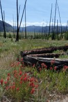
Arizona Creek Trailhead

Rog and Judy on the trail
Day 2: Brown Meadows to Wolverine Creek (10 mi)
Country getting a bit more rugged. Also more hiking in the 1988 burn. About a mile of the route is essentially in Rodent Creek. Interesting hiking, actually. The flies are pretty bad today—what I might call black flies (but different from Great Lakes region black flies), and B-52s. If you have experienced those huge biting flies, you know what I am talking about.
We are getting good at dealing with deadfall at this point. Evidently, the trail has not been cleared in a while.
Finally in sight of the large meadow at Wolverine Creek. Seemed to take forever to get down there and we had trouble finding a decent campsite. We ended up camping way out in the middle of the meadow—likely camping spots on the perimeter of the meadow in shade were all either swampy or brushy.
 Early morning in Brown Meadows. Looking west toward Tetons.

Rodent Creek
 Wolverine Creek Meadows
Day 3: Wolverine Creek to Fox Creek (8 mi)
Quite a bit of old bear scat on the trail and overturned logs beside the trail, we assume from bears looking for insects, but no fresh signs. The trail junction for Big Game Ridge is very indistinct. We had to backtrack and search carefully to find it. Once on Big Game Ridge we apparently missed the trail over to Fox Park. Eventually found that one too after wasting an hour or so.
By now it really feels like we are in the middle of nowhere. Realized at some point we hadn’t seen a human or equine foot print since the first day. The country is not spectacular in an alpine sense but it is wild and remote.
Camped along Fox Creek just before trail crosses the creek and heads over to Fox Park. Nice swimming hole in Fox Creek near campsite. It was hot again today—a swim was welcome relief.

View westward from Big Game Ridge back along our route

Jason squeezing us some water
Day 4: Fox Creek to Phelps Pass (6 mi)
Wanted to camp near Bridger Lake in Yellowstone River valley—we could either hike over there in one very long day or two short ones. Decided on two short days with a camp near Phelps Pass. We arrived at Fox Park early in the morning and spent a while looking out over it with binoculars. Fox Park is immense—the scale of everything out here is deceptively large.
Hadn’t planned it but ended up passing by the patrol cabin at Fox Park and chatted with the caretakers for a bit. That would be a unique way to spend the summer. Pleasant hiking again today through meadows and forest. Bear and wolf tracks but nothing but deer to be seen. The CDT shares part of this route and we met one hiker headed for Yellowstone—the only other hiker we saw until the end of the last day of the hike. Found a nice campsite in Mink Creek valley just before Phelps Pass. We were plenty early so hiked up trail onto Two Ocean Plateau to look around. Some pretty little lakes up there and good views of the Tetons. Also discovered about a 10 square foot area with perfect cellphone reception. We called our wives.

Early morning at Fox Park

Lunch stop along Mink Creek
Day 5: Phelps Pass to Bridger Lake (6 mi)
Nice easy day today but still hot. Made Yellowstone Meadows by midday and felt pretty much baked by the sun. Quite a dramatic change in scenery from the gentle valleys, forest and meadows of the first few days to the massive Yellowstone River valley. We forded the river and spent a little time floating in the water to cool off. Spectacular wildflowers in the burn headed down from Falcon Creek valley to Yellowstone Meadows. We spotted what appeared to be a nice campsite on a promontory just north of Bridger Lake. A little out of the way but we thought we could catch a breeze and have nice views of the lake. There are several outfitter camps along the trail past the ford. Quite spacious and complete with bearproof food storage. We elected to head for higher ground above the lake.
It was a nice site although a little lacking in shade. We selected a tent site, hung our food and set off on a day hike up to Thorofare Creek in Yellowstone Park. Once again, we were fooled by the massive scale of everything here and the hike turned out to be longer than we had planned. Thorofare Creek was an interesting contrast to the Yellowstone River. Much higher gradient and coarser streambed sediment. We found a lot of nice petrified wood. You could pretty much stand anywhere and see numerous pieces all around you in the cobbles. Yes, we left it all there.
There were geese, ducks, swans and a bald eagle on and around Bridger Lake. The geese were quite restless and kept honking and flitting about. In fact they never settled down all night long. By morning they had become “those f***ing geese”. We renamed the lake Goose Lake. Something very large came clomping through camp in the night. It sounded like it plunged right into the lake after passing our camp—maybe a moose? We could not find any tracks. We heard a lot of sandhill cranes out on the floodplain but never saw any. We cooked with water from the lake, which was interesting due to all the little things swimming around in it. Even though we knew we could just boil the critters and consume them it was just too gross so we filtered them out with a bandana.

Yellowstone River Valley and Bridger Lake

Headed into Yellowstone valley

Flowers and burned trees
 Fording the Yellowstone
Day 6: Bridger Lake to Woodard Canyon trail (13 mi)
We headed up the canyon on a very nice trail today. Nice not to be climbing over and around deadfall all the time--nice views too. We finally saw a couple of sandhill cranes waaaay out on the floodplain. By the afternoon thunderstorms were kicking up and it looked like we were about to get slammed. We donned our raingear just in time for the rain to stop, so we packed it away. It started to rain again, we suited up again and it stopped again. That was the extent of rain for the whole trip—barely enough to settle the dust.
The trail goes through a couple of massive landslide deposits. Very strange topography with weird knobs, depressions and blocks of rock. Must have been spectacular events. Seems like they should have dammed up the river but we could see no evidence of that. We found what has to be the perfect swimming hole. A nice gravel bar on a horseshoe bend of the river next to chest-deep water. We dove in and floated for a bit. Water much colder here than down at the ford. And lots of petrified wood in a great variety of forms.
About a mile before the Woodard Canyon junction the river has carved a spectacular gorge. The rock contains loads of—yes—petrified wood, and it is just lying all over the place. We called it Petrified Gorge. Camped in a nice meadow right near the Woodard Canyon trail intersection.

Beaver pond

Thought it might rain

We named this Petrified Gorge for all the petrified wood exposed here

Campsite near Woodard Canyon trail intersection
Day 7: Woodard Canyon to S. Yellowstone headwaters (10 mi)
We continued our pleasant jaunt up the canyon anticipating a bit of climbing to reach the lower meadow. The climb was not bad in terms of net elevation gain but the trail would have made a great roller-coaster track. Straight up to bypass some obstacle, then right back down—over and over again. It was brutal. The meadow was beautiful, however—well worth the pain. Also worth the stinging nettles we had to wade through at the lower end. I had on lightweight hiking pants and the dang nettles got to me right through the fabric. Jason’s pants were slightly heavier and he was unaffected. Nice hiking up to the upper meadow—a bit of climbing but not bad.
The plan for today was to camp near the top of the S. Fork Yellowstone valley so we can climb Younts Peak tomorrow. There was one hitch in our plan, however. We brought one large bear canister plus a hanging sack. We figured that by the time we were above treeline all the food would fit in the cannister. We were pretty close with the food but we had not factored in the food-wrapper trash that would also need to be bear-proofed. So for at least a couple more nights we’d still need to hang some food. We would need to choose a campsite near a decent-sized cliff where we could hang the food sack. The S. Yellowstone Cirque didn’t seem to include any such opportunities so we continued up the trail and through the pass toward Lost Creek. We soon found a nice campsite near a sufficiently tall crag. The approach to Younts would be longer but still not too bad.

South Fork Yellowstone lower meadow

South Fork Yellowstone lower meadow

South Fork Yellowstone upper meadow

Yup, flowers

Camp between S. Fork Yellowstone and Marson Pass
Day 8: Younts Peak
The best route appears to be to contour around the top of the S. Yellowstone cirque, cut across below the S face of the mountain and gain the summit ridge in a saddle W of the mountain. We hiked all the way up to the divide between the N and S forks of the Yellowstone—you don’t need to go that high but it’s a nice view from there. It is easy going all the way from there to the W edge of the cirque that makes the S face of the peak. After that the terrain is steep and rocky but there is a well-worn footpath through the worst of it. Once to the saddle you just turn right and slog your way to the top.
Driving to the trailhead before the trip we noticed some smoke south of the highway near Brooks Lake. Turns out it flared up into the Lava Mountain fire and we could see lots of smoke today off to the south.
We hung out on top for a long time eating salami and crackers and taking pictures. Looking closely at the summit rocks you could see glassy material formed from lightning strikes. Luckily it was another beautiful, clear day so we did not have to worry about the weather up there.
We pretty much retraced our steps back to camp but on the way managed to sneak up on a bear in the S. Yellowstone cirque. We contoured around and crossed a little gulley and spotted a young adult griz headed down the swale away from us. We were downwind of the bear and less than 100 yds away so we ducked behind a rock and let it do its thing while we waited. Fortunately it had business lower down the drainage and continued downhill and away from us for as long as we could see it. It finally disappeared in some brush a good half-mile away and we resumed our hike.
Back at camp it was still warm enough for a swim in a little tarn above camp. There was a big snowbank adjacent to the water so it looked like it would be achingly cold but on the far end the water was not bad at all. I have never been so clean on a backcountry trip. On this trip we got in the water almost every day, sometimes multiple times per day.

Our camp with Younts Peak in background

On the way to the peak

The last part of the climb

Summit selfie

Glass formed from lightning-melted rock

View west from summit down Yellowstone River valley.

Bear we met on the way down
 Small tarn above camp. Water was not very cold over there.
Day 9: S. Yellowstone headwaters to Buffalo Plateau (7 mi not including numerous course corrections)
Today we followed the Lost Creek trail for a ways then split off to the south more or less parallel to the continental divide. Studying the map beforehand we figured the main thing to avoid would be getting sucked too far to the west where one would have to negotiate all sorts of ups and downs. But even with that awareness somehow at every turn, every choice we made took us just a little bit too far west every time. Every. Single. Time. Every time we plotted our position we were just a little west of where we wanted to be and it seemed that no amount of course correction would bring us back to our planned route. Now, this new route was probably more scenic than the planned route but it involved a lot more zig-zagging and up-and-down. And the frustration of not being able to hold to the planned course--it was kind of weird, actually. We eventually fought our way back on course and found a great campsite overlooking a pretty little valley high on the plateau. Saw a lone bull elk at one point. He was bobbing his head around as though trying to show us his antlers. Pretty cool.
Lots of smoke to the south again today. Huge billowing clouds of smoke that seemed to merge with cumulus clouds above. We were a little worried that the fire might burn its way up toward Brooks Lake and trap us or burn up the car.

Near Marston Pass

On Buffalo Plateau south of Lost Creek

He wagged his head around like he was showing off his antlers

Valley on Buffalo Plateau

Our campsite with smoke from the Lava Mountain Fire in the distance
Day 10: Buffalo Plateau to Cub Creek (12 mi)
Today we continued along the divide over toward Crescent Mt. More ups and downs to negotiate the many canyons that cut into the plateau… As we had done on other mornings we broke camp and got moving right away to put in a few miles before breakfast. The route was drier than anticipated and we had to drop into one of the valleys for cooking water. Turned out to be fortuitous, however, as the valley was a great place to hang out for a while and there was a really nice spring where you could see the water jetting up through sand in the bed of the spring. I think dropping into the valley was the superior route choice as well, water or not.
The climb out of the head of Crescent Canyon to the main part of Crescent Mt. was the only leg of the route we were at all unsure about. Turned out it was very steep but there was a fairly prominent trail that switchbacked up the worst of it.
Contoured around the mountain headed for the divide between S. Buffalo Fork and Cub Creek. Jason suddenly whispered “bear” and ducked behind a rock. I followed and peeked out to see a mother Griz and cub a nice, comfortable distance away. Mom seemed to be turning over rocks and baby was playing on the snow. We sat and watched for quite a while. They did not seem to have plans to go anywhere so we adjusted our course to give them a nice, wide buffer and headed down to Cub Creek. I had been this way before and recalled that campsites were few and far between for a good ways in the canyon so we figured we’d head down for a few miles and camp at the first decent spot. We found a nice patch of meadow and set up camp. It was hot as shite again so we got in the creek before dinner. No good swimming hole but possible to lie down among the rocks for a good full-body chill.

We headed down into the valley and had breakfast by the spring. Then climbed the slope just left of the trees and headed to the right along the ridge toward Crescent Mountain.

Nice breakfast stop

We saw this mother bear and her cub near Crescent Mountain

Heading down to Cub Creek
Day 11: Cub Creek to Brooks Lake (7 mi)
Today the only thing we had to watch out for was missing where the trail crosses Cub Creek and heads over to Brooks Lake. From my previous trip I remembered that the trail sort of branches out all over the place and it’s easy to miss the crossing. Sure enough, we missed it and were climbing up the other side of the valley before visions of fresh food and a hot shower gave way to the realization that we still needed our brains for routefinding. Luckily we didn’t overshoot by much so were able to quickly backtrack to the crossing.
On the south side of Cub Creek the trail wanders away from the creek through another huge landslide with chaotic topography and many ponds. Seemed the perfect place for a moose but we didn’t see any. We finally arrived at the Brooks Lake train junction and headed up there on a suddenly much wider trail with lots of fresh bootprints. Still, we didn’t meet any other hikers until we were almost to Upper Brooks Lake. By the way, we parked at the Bonnevile Pass trailhead. If you want to hike up Cub creek it’s actually closer than the Brooks Lake trailhead, you avoid a couple of stream crossings, and there is more shade. You have to climb a little but not much.
The fire stayed south of the highway so we were not trapped and the car did not burn up. It was a little smoky but the road was open and we had no trouble getting to Dubois. Dubois was really hopping—there was a big staging area there for fighting the fire. Turned out it had burned a pretty big area and was threatening quite a few homes outside Dubois. They seemed to be throwing everything they had at it. Anyway, we hit the showers at the laundromat, ate burgers at Daylight Donuts and hit the road.

About here we realized we overshot the crossing point on Cub Creek. Time to backtrack.
Reflections
It was a trip for the ages. One of the greatest things was the landscape change throughout the hike. The western Teton Wilderness is spectacular in a subtle way—it is huge, serious, middle-of-nowhere wilderness that seems to go on forever. The Thorofare area is another kind of massive scale wilderness—the Yellowstone River Valley is almost unbelievably wide and surrounded by high mountains. The Buffalo Plateau is all above treeline with everything that entails. Except for the one CDT hiker and the Fox Park caretakers we saw no one else. There were long stretches of trail with more bear and wolf tracks than horse or human prints. The deadfall was annoying but not excessive and except for a couple of short stretches the trail was easy to follow, as long as you were paying attention to the map. There were even signposts at many trail intersections. We brought the USGS 7.5 minute quads and were very glad we had them. It took a dozen maps to cover the route—we chopped them to save weight (almost unbearable to cut them like that). I suppose GPS would have been nice but we didn’t bother with it. We were forewarned but even so the Buffalo Plateau was confusing country to navigate.
Day 1: AZ Ck TH to Brown Meadows (8 mi)
My parents, Rog and Judy, were vacationing in the area and helped us set up the shuttle—we dropped the car at Brooks Lake (actually Bonneville Pass parking area) and drove to Arizona Creek TH. In their mid-80s, they have given up backpacking but still enjoy day hiking. On the trail about 11:00 AM. Rog and Judy hiked as far as AZ creek stream crossing. We had lunch there then they turned back. Getting warm.
Enjoyable hiking through forest, burned forest (1988 fires) and meadows. Limited water after leaving Arizona Creek. It’s clear that few people hike this trail but we could see that someone had been on the trail recently.
Set up camp at W edge of Brown Meadows. Pleasant camping among scattered pine trees; water nearby. Someone else had camped here a night or two ago—there was a rectangular patch of compressed grass.
Arizona Creek Trailhead
Rog and Judy on the trail
Day 2: Brown Meadows to Wolverine Creek (10 mi)
Country getting a bit more rugged. Also more hiking in the 1988 burn. About a mile of the route is essentially in Rodent Creek. Interesting hiking, actually. The flies are pretty bad today—what I might call black flies (but different from Great Lakes region black flies), and B-52s. If you have experienced those huge biting flies, you know what I am talking about.
We are getting good at dealing with deadfall at this point. Evidently, the trail has not been cleared in a while.
Finally in sight of the large meadow at Wolverine Creek. Seemed to take forever to get down there and we had trouble finding a decent campsite. We ended up camping way out in the middle of the meadow—likely camping spots on the perimeter of the meadow in shade were all either swampy or brushy.
Early morning in Brown Meadows. Looking west toward Tetons.Rodent Creek
Wolverine Creek MeadowsDay 3: Wolverine Creek to Fox Creek (8 mi)
Quite a bit of old bear scat on the trail and overturned logs beside the trail, we assume from bears looking for insects, but no fresh signs. The trail junction for Big Game Ridge is very indistinct. We had to backtrack and search carefully to find it. Once on Big Game Ridge we apparently missed the trail over to Fox Park. Eventually found that one too after wasting an hour or so.
By now it really feels like we are in the middle of nowhere. Realized at some point we hadn’t seen a human or equine foot print since the first day. The country is not spectacular in an alpine sense but it is wild and remote.
Camped along Fox Creek just before trail crosses the creek and heads over to Fox Park. Nice swimming hole in Fox Creek near campsite. It was hot again today—a swim was welcome relief.
View westward from Big Game Ridge back along our route
Jason squeezing us some water
Day 4: Fox Creek to Phelps Pass (6 mi)
Wanted to camp near Bridger Lake in Yellowstone River valley—we could either hike over there in one very long day or two short ones. Decided on two short days with a camp near Phelps Pass. We arrived at Fox Park early in the morning and spent a while looking out over it with binoculars. Fox Park is immense—the scale of everything out here is deceptively large.
Hadn’t planned it but ended up passing by the patrol cabin at Fox Park and chatted with the caretakers for a bit. That would be a unique way to spend the summer. Pleasant hiking again today through meadows and forest. Bear and wolf tracks but nothing but deer to be seen. The CDT shares part of this route and we met one hiker headed for Yellowstone—the only other hiker we saw until the end of the last day of the hike. Found a nice campsite in Mink Creek valley just before Phelps Pass. We were plenty early so hiked up trail onto Two Ocean Plateau to look around. Some pretty little lakes up there and good views of the Tetons. Also discovered about a 10 square foot area with perfect cellphone reception. We called our wives.
Early morning at Fox Park
Lunch stop along Mink Creek
Day 5: Phelps Pass to Bridger Lake (6 mi)
Nice easy day today but still hot. Made Yellowstone Meadows by midday and felt pretty much baked by the sun. Quite a dramatic change in scenery from the gentle valleys, forest and meadows of the first few days to the massive Yellowstone River valley. We forded the river and spent a little time floating in the water to cool off. Spectacular wildflowers in the burn headed down from Falcon Creek valley to Yellowstone Meadows. We spotted what appeared to be a nice campsite on a promontory just north of Bridger Lake. A little out of the way but we thought we could catch a breeze and have nice views of the lake. There are several outfitter camps along the trail past the ford. Quite spacious and complete with bearproof food storage. We elected to head for higher ground above the lake.
It was a nice site although a little lacking in shade. We selected a tent site, hung our food and set off on a day hike up to Thorofare Creek in Yellowstone Park. Once again, we were fooled by the massive scale of everything here and the hike turned out to be longer than we had planned. Thorofare Creek was an interesting contrast to the Yellowstone River. Much higher gradient and coarser streambed sediment. We found a lot of nice petrified wood. You could pretty much stand anywhere and see numerous pieces all around you in the cobbles. Yes, we left it all there.
There were geese, ducks, swans and a bald eagle on and around Bridger Lake. The geese were quite restless and kept honking and flitting about. In fact they never settled down all night long. By morning they had become “those f***ing geese”. We renamed the lake Goose Lake. Something very large came clomping through camp in the night. It sounded like it plunged right into the lake after passing our camp—maybe a moose? We could not find any tracks. We heard a lot of sandhill cranes out on the floodplain but never saw any. We cooked with water from the lake, which was interesting due to all the little things swimming around in it. Even though we knew we could just boil the critters and consume them it was just too gross so we filtered them out with a bandana.
Yellowstone River Valley and Bridger Lake
Headed into Yellowstone valley
Flowers and burned trees
Fording the YellowstoneDay 6: Bridger Lake to Woodard Canyon trail (13 mi)
We headed up the canyon on a very nice trail today. Nice not to be climbing over and around deadfall all the time--nice views too. We finally saw a couple of sandhill cranes waaaay out on the floodplain. By the afternoon thunderstorms were kicking up and it looked like we were about to get slammed. We donned our raingear just in time for the rain to stop, so we packed it away. It started to rain again, we suited up again and it stopped again. That was the extent of rain for the whole trip—barely enough to settle the dust.
The trail goes through a couple of massive landslide deposits. Very strange topography with weird knobs, depressions and blocks of rock. Must have been spectacular events. Seems like they should have dammed up the river but we could see no evidence of that. We found what has to be the perfect swimming hole. A nice gravel bar on a horseshoe bend of the river next to chest-deep water. We dove in and floated for a bit. Water much colder here than down at the ford. And lots of petrified wood in a great variety of forms.
About a mile before the Woodard Canyon junction the river has carved a spectacular gorge. The rock contains loads of—yes—petrified wood, and it is just lying all over the place. We called it Petrified Gorge. Camped in a nice meadow right near the Woodard Canyon trail intersection.
Beaver pond
Thought it might rain
We named this Petrified Gorge for all the petrified wood exposed here
Campsite near Woodard Canyon trail intersection
Day 7: Woodard Canyon to S. Yellowstone headwaters (10 mi)
We continued our pleasant jaunt up the canyon anticipating a bit of climbing to reach the lower meadow. The climb was not bad in terms of net elevation gain but the trail would have made a great roller-coaster track. Straight up to bypass some obstacle, then right back down—over and over again. It was brutal. The meadow was beautiful, however—well worth the pain. Also worth the stinging nettles we had to wade through at the lower end. I had on lightweight hiking pants and the dang nettles got to me right through the fabric. Jason’s pants were slightly heavier and he was unaffected. Nice hiking up to the upper meadow—a bit of climbing but not bad.
The plan for today was to camp near the top of the S. Fork Yellowstone valley so we can climb Younts Peak tomorrow. There was one hitch in our plan, however. We brought one large bear canister plus a hanging sack. We figured that by the time we were above treeline all the food would fit in the cannister. We were pretty close with the food but we had not factored in the food-wrapper trash that would also need to be bear-proofed. So for at least a couple more nights we’d still need to hang some food. We would need to choose a campsite near a decent-sized cliff where we could hang the food sack. The S. Yellowstone Cirque didn’t seem to include any such opportunities so we continued up the trail and through the pass toward Lost Creek. We soon found a nice campsite near a sufficiently tall crag. The approach to Younts would be longer but still not too bad.
South Fork Yellowstone lower meadow
South Fork Yellowstone lower meadow
South Fork Yellowstone upper meadow
Yup, flowers
Camp between S. Fork Yellowstone and Marson Pass
Day 8: Younts Peak
The best route appears to be to contour around the top of the S. Yellowstone cirque, cut across below the S face of the mountain and gain the summit ridge in a saddle W of the mountain. We hiked all the way up to the divide between the N and S forks of the Yellowstone—you don’t need to go that high but it’s a nice view from there. It is easy going all the way from there to the W edge of the cirque that makes the S face of the peak. After that the terrain is steep and rocky but there is a well-worn footpath through the worst of it. Once to the saddle you just turn right and slog your way to the top.
Driving to the trailhead before the trip we noticed some smoke south of the highway near Brooks Lake. Turns out it flared up into the Lava Mountain fire and we could see lots of smoke today off to the south.
We hung out on top for a long time eating salami and crackers and taking pictures. Looking closely at the summit rocks you could see glassy material formed from lightning strikes. Luckily it was another beautiful, clear day so we did not have to worry about the weather up there.
We pretty much retraced our steps back to camp but on the way managed to sneak up on a bear in the S. Yellowstone cirque. We contoured around and crossed a little gulley and spotted a young adult griz headed down the swale away from us. We were downwind of the bear and less than 100 yds away so we ducked behind a rock and let it do its thing while we waited. Fortunately it had business lower down the drainage and continued downhill and away from us for as long as we could see it. It finally disappeared in some brush a good half-mile away and we resumed our hike.
Back at camp it was still warm enough for a swim in a little tarn above camp. There was a big snowbank adjacent to the water so it looked like it would be achingly cold but on the far end the water was not bad at all. I have never been so clean on a backcountry trip. On this trip we got in the water almost every day, sometimes multiple times per day.
Our camp with Younts Peak in background
On the way to the peak
The last part of the climb
Summit selfie
Glass formed from lightning-melted rock
View west from summit down Yellowstone River valley.
Bear we met on the way down
Small tarn above camp. Water was not very cold over there.Day 9: S. Yellowstone headwaters to Buffalo Plateau (7 mi not including numerous course corrections)
Today we followed the Lost Creek trail for a ways then split off to the south more or less parallel to the continental divide. Studying the map beforehand we figured the main thing to avoid would be getting sucked too far to the west where one would have to negotiate all sorts of ups and downs. But even with that awareness somehow at every turn, every choice we made took us just a little bit too far west every time. Every. Single. Time. Every time we plotted our position we were just a little west of where we wanted to be and it seemed that no amount of course correction would bring us back to our planned route. Now, this new route was probably more scenic than the planned route but it involved a lot more zig-zagging and up-and-down. And the frustration of not being able to hold to the planned course--it was kind of weird, actually. We eventually fought our way back on course and found a great campsite overlooking a pretty little valley high on the plateau. Saw a lone bull elk at one point. He was bobbing his head around as though trying to show us his antlers. Pretty cool.
Lots of smoke to the south again today. Huge billowing clouds of smoke that seemed to merge with cumulus clouds above. We were a little worried that the fire might burn its way up toward Brooks Lake and trap us or burn up the car.
Near Marston Pass
On Buffalo Plateau south of Lost Creek
He wagged his head around like he was showing off his antlers
Valley on Buffalo Plateau
Our campsite with smoke from the Lava Mountain Fire in the distance
Day 10: Buffalo Plateau to Cub Creek (12 mi)
Today we continued along the divide over toward Crescent Mt. More ups and downs to negotiate the many canyons that cut into the plateau… As we had done on other mornings we broke camp and got moving right away to put in a few miles before breakfast. The route was drier than anticipated and we had to drop into one of the valleys for cooking water. Turned out to be fortuitous, however, as the valley was a great place to hang out for a while and there was a really nice spring where you could see the water jetting up through sand in the bed of the spring. I think dropping into the valley was the superior route choice as well, water or not.
The climb out of the head of Crescent Canyon to the main part of Crescent Mt. was the only leg of the route we were at all unsure about. Turned out it was very steep but there was a fairly prominent trail that switchbacked up the worst of it.
Contoured around the mountain headed for the divide between S. Buffalo Fork and Cub Creek. Jason suddenly whispered “bear” and ducked behind a rock. I followed and peeked out to see a mother Griz and cub a nice, comfortable distance away. Mom seemed to be turning over rocks and baby was playing on the snow. We sat and watched for quite a while. They did not seem to have plans to go anywhere so we adjusted our course to give them a nice, wide buffer and headed down to Cub Creek. I had been this way before and recalled that campsites were few and far between for a good ways in the canyon so we figured we’d head down for a few miles and camp at the first decent spot. We found a nice patch of meadow and set up camp. It was hot as shite again so we got in the creek before dinner. No good swimming hole but possible to lie down among the rocks for a good full-body chill.
We headed down into the valley and had breakfast by the spring. Then climbed the slope just left of the trees and headed to the right along the ridge toward Crescent Mountain.
Nice breakfast stop
We saw this mother bear and her cub near Crescent Mountain
Heading down to Cub Creek
Day 11: Cub Creek to Brooks Lake (7 mi)
Today the only thing we had to watch out for was missing where the trail crosses Cub Creek and heads over to Brooks Lake. From my previous trip I remembered that the trail sort of branches out all over the place and it’s easy to miss the crossing. Sure enough, we missed it and were climbing up the other side of the valley before visions of fresh food and a hot shower gave way to the realization that we still needed our brains for routefinding. Luckily we didn’t overshoot by much so were able to quickly backtrack to the crossing.
On the south side of Cub Creek the trail wanders away from the creek through another huge landslide with chaotic topography and many ponds. Seemed the perfect place for a moose but we didn’t see any. We finally arrived at the Brooks Lake train junction and headed up there on a suddenly much wider trail with lots of fresh bootprints. Still, we didn’t meet any other hikers until we were almost to Upper Brooks Lake. By the way, we parked at the Bonnevile Pass trailhead. If you want to hike up Cub creek it’s actually closer than the Brooks Lake trailhead, you avoid a couple of stream crossings, and there is more shade. You have to climb a little but not much.
The fire stayed south of the highway so we were not trapped and the car did not burn up. It was a little smoky but the road was open and we had no trouble getting to Dubois. Dubois was really hopping—there was a big staging area there for fighting the fire. Turned out it had burned a pretty big area and was threatening quite a few homes outside Dubois. They seemed to be throwing everything they had at it. Anyway, we hit the showers at the laundromat, ate burgers at Daylight Donuts and hit the road.
About here we realized we overshot the crossing point on Cub Creek. Time to backtrack.
Reflections
It was a trip for the ages. One of the greatest things was the landscape change throughout the hike. The western Teton Wilderness is spectacular in a subtle way—it is huge, serious, middle-of-nowhere wilderness that seems to go on forever. The Thorofare area is another kind of massive scale wilderness—the Yellowstone River Valley is almost unbelievably wide and surrounded by high mountains. The Buffalo Plateau is all above treeline with everything that entails. Except for the one CDT hiker and the Fox Park caretakers we saw no one else. There were long stretches of trail with more bear and wolf tracks than horse or human prints. The deadfall was annoying but not excessive and except for a couple of short stretches the trail was easy to follow, as long as you were paying attention to the map. There were even signposts at many trail intersections. We brought the USGS 7.5 minute quads and were very glad we had them. It took a dozen maps to cover the route—we chopped them to save weight (almost unbearable to cut them like that). I suppose GPS would have been nice but we didn’t bother with it. We were forewarned but even so the Buffalo Plateau was confusing country to navigate.
Attachments
Last edited:
") Thanks a lot!
Thanks a lot!