Step Canyon access to Grand Gulch, Cedar Mesa

TrailScot

Member
.
Joined
Dec 2, 2019
Messages
137
Hi,

Does anyone have any experience of using Step Canyon as an entry/exit route to Grand Gulch ?

Kelsey makes the route sound relatively straightforward (!), but other trip reports that I've come across make it sound like a more difficult challenge.

Thanks for any advice.
 
I had some difficulties heading up Step after descending Pine, in the lower part of the canyon. It was a while ago so I don't remember exactly what the obstacle was, just that I did not feel comfortable climbing up with a pack. My $.02, Kelsey is not a good, accurate resource. You will get accurate and better input in BCP.
 
Last edited:
I would agree with @LarryBoy about Kelsey. His books are great for getting an idea, but can be pandora's box on the ground.
If you figure out how to get in through Step Canyon, please PM me as I'd love to know as well.
 
I don't know of anyone who has accessed GG from Step. I would think that if it were an easy way into GG, more people would be using it.

Yes, you're absolutely correct, Randy ... after finding no online reports for this route, I suspected as much; but hoped otherwise, after reading Kelsey's brief description
 
I have it as a entrance in.... From a old map a friend of mine had that helped lay out the GC boundaries.... So I'd assume it goes .... Other than that you are on your own.....

I have looked at a loop kinda the same years ago but never got to it

Always take a 40 ft piece of webbing in new Canyon country
 
In a recent visit to the Cedar Mesa area, I hoped to be able to find out if Step Canyon provided access to Grand Gulch.

I started just off Highway 276 at the cut-off to the Collins Trailhead, headed across the mesa, and dropped into Dripping Canyon. After negotiating the tricky ledge in the lower part of Dripping, I was soon hiking along the pleasant sandy trail in Grand Gulch. It was about 2.5 miles to the junction with Step Canyon.

The lower section of Step, below the Junction with Pine Canyon is very straightforward, with no significant obstacles. At times, it is necessary to step up from the drainage itself, since it is a little brushy in places and narrows into a slickrock 'slot'.

Soon after the junction, there is a high pour-off, with a bypass on the right-hand side. The bypass is not difficult, but requires a little consideration. Initially, a 6-foot high ledge is negotiated using a pile of rocks and tree branches left by previous hikers. After scaling this, the temptation is to rejoin the drainage by heading left, but it seems simpler to edge slightly right, and clamber up an easier slickrock slope.

A little further up the canyon is a large sandstone bowl, with a slickrock chute connecting the upper and lower sections. At the bottom of the chute is an ultra-smooth 4 foot high almost vertical section. If heading down-canyon, this would a straightforward slide down but, in the opposite direction, it's a little tricky. I placed a thick tree-trunk that was lying close by against the chute, and it was easy to clamber up.

After exiting Step Canyon a little later, I joined an old dirt road and made my way back to Highway 276. I hadn't initially realized that this was actually part of the 1880 Pioneer route, as they crossed Cedar Mesa. A few weeks previously, this group of 250 Mormon pioneers had already crossed the Colorado River after blasting an incredible passageway through vertical sandstone cliffs at the Hole-in-the-Rock. In a week's time they would be constructing another remarkable 'road' to cross Grand Gulch.

The dirt road that I followed had plenty of evidence of the pioneer route, which made it a great pleasure to walk in the evening sun, as I headed back to my car after an excellent day's hiking.​
 
Last edited:
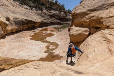
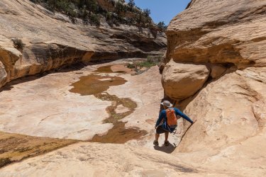
First crux going down Step. This is the bottom of the steep pourover, its not bad just a friction climb. Looked much sketchier my first time looking down from the top.
2A4A6347.jpg

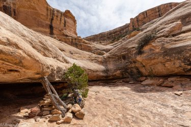
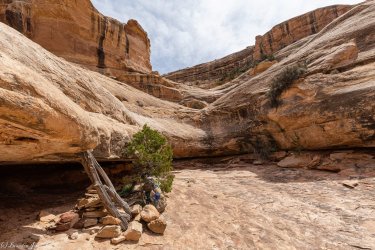
Second pourover, the real crux of Step. Like @TrailScot said, it's to the left going down canyon. Tough to see unless you're on top of it, some steep ledges will get you there. I dropped my pack but you could lower it with a short rope if you wanted, its not that tall. Easier going up, fun climb once you find it. Not really any exposure here, just some balance and friction moves.
2A4A6319.jpg
 

Attachments

  • 2A4A6347.jpg
    2A4A6347.jpg
    449.7 KB · Views: 4
  • 2A4A6319.jpg
    2A4A6319.jpg
    546.9 KB · Views: 4
First crux going down Step. This is the bottom of the steep pourover, its not bad just a friction climb. Looked much sketchier my first time looking down from the top.
View attachment 127421

Second pourover, the real crux of Step. Like @TrailScot said, it's to the left going down canyon. Tough to see unless you're on top of it, some steep ledges will get you there. I dropped my pack but you could lower it with a short rope if you wanted, its not that tall. Easier going up, fun climb once you find it. Not really any exposure here, just some balance and friction moves.
View attachment 127422

Great ... many thanks for that ... at least someone had their camera at the ready, when tackling these obstacles :) ... I completely forgot ...
 
In the second pic aren't the logs/rock pile canyon right?
sorry that was confusing...TrailScot came up from the bottom so it was right side for him. The downclimb is on the left looking down canyon.
 
The second pic is looking up canyon. If so it looks like the rock pile/logs would be canyon rt ( Rt looking down canyon )
Thanks
 
The second pic is looking up canyon. If so it looks like the rock pile/logs would be canyon rt ( Rt looking down canyon )
Thanks
That's a side canyon tributary of Step. I tried looking for a route up to explore but it's ledged out.
 
OK. That clears it up. Thanks. Hope you got to see all the great archaeology in the lower canyon.
 
Similar threads
Thread starter Title Forum Replies Date
gnwatts Step Canyon 5-17-13 Hiking & Camping 5
gnwatts Pine and Step Canyon. 2006 & 2013 Hiking & Camping 7
Perry Step Inside for a Scat Scan General Discussion 54
J Reflection Canyon Trip Planning 3
fossana Found: prescription glasses near the top of the Flipoff Canyon approach General Discussion 5
Spud Salt Creek Canyon question Trip Planning 11
B Buckskin gulch/Pariah canyon Carpool Trip Planning 0
TractorDoc Paintbrush Canyon / Cascade Canyon Loop -- Grand Teton NP September 11, 2023 Hiking & Camping 9
Kullaberg63 15 day canyon route Backpacking 13
Titans Tricked in the canyon! Hiking & Camping 5
TrailScot Dayhiking the Under-the-Rim Trail - Bryce Canyon NP - October 2023 Hiking & Camping 4
Janice Such a GRAND Canyon - Deer Creek / Tapeats / Thunder River Backpacking 21
M Mee/Knowles Canyon Loop, Grand Junction Colorado Backpacking 4
OldBill Short hike at the Grand Canyon of Pennsylvania Hiking & Camping 1
S Paria Canyon- Whitehouse to Lees Ferry, Oct 18 to 21, 2023 Trip Reports 0
scatman Yellowstone's Thorofare, Headwaters of Thorofare Creek, Majo Pass, Younts Peak, Bob's Canyon, and Cub Creek - August 9, 2023 - Days 7 through 10 Backpacking 34
scatman Yellowstone's Thorofare, Headwaters of Thorofare Creek, Majo Pass, Younts Peak, Bob's Canyon, and Cub Creek - August 9, 2023 - Days 1 through 6 Backpacking 56
A Bowdie Canyon Trip Planning 10
TheMountainRabbit Silas Canyon (Popo Agie Wilderness) - August 2023 Backpacking 3
J Paria Canyon - One Day Trail Trip Planning 10
Bob The New Grand Canyon Trip Planning 1
WhozWutz Invite Horse Canyon Needles Meet Up (Members Only) 1
BJett Part 3 - Tour de Canyon Country. Lower Escalante Loop Hiking & Camping 0
BJett Part 2 - Tour de Canyon Country. Swell Times Hiking & Camping 0
BJett Part 1 - Tour de Canyon Country. Cedar Mesa. Hiking & Camping 8
Gretchen Millward Trachyte Creek via Woodruff Canyon, April 2023 Backpacking 9
F Grand Canyon hermits rest to granite rapids to bright angel Trip Planning 10
gnwatts Stillwater Canyon On The Water 11
shredhiker Kings Canyon July 2022 Kearsarge, Rae, & Sixty Lakes Backpacking 8
J Info needed: Bown's Canyon, Long Canyon Trip Planning 8
Gretchen Millward Cheesebox Canyon, Oct. 2022 Backpacking 14
Stickerbumper Fold Canyon Middle Exit Trip Planning 9
Janice Professor Creek / Mary Jane Canyon - mid April? Trip Planning 0
D Horseshoe Canyon or San Rafael Swell? Trip Planning 9
scatman North Ridge of City Creek Canyon - February 4, 2023 Hiking & Camping 17
scatman South Ridge of City Creek Canyon - January 28, 2023 Hiking & Camping 4
NorthwestWanderer 8 Day High Sierra trek : Humphreys Basin, Star Col, Granite Park, Lake Italy & Piute Canyon 6/25-7/2/22 Backpacking 7
T Amazing Discovery in Utah-Glen Canyon Trip Planning 65
Titans What’s your unfinished business? Hard canyon access, mtn peak, you name it! General Discussion 54
SteveR Big Spring-Elephant Canyon dayhike. With free bonus vacation pix! Hiking & Camping 13
Stephanie B Dirty Devil River Impassible at Poison Springs Canyon Off Road 0
LarryBoy Is there anything technical in White Canyon above the Black Hole? Trip Planning 16
dennisrodman A week in the Grand Canyon / Boucher / Hermit / Tonto Trail Trip Planning 4
XID_AZ Kanab Creek Wilderness - Sowats Canyon - Mountain Sheep Spring Trip Planning 6
travel2walk Yellowstone: Bechler Canyon, Aug 12-15 2022 Backpacking 21
balzaccom Mok Canyon Solitude for my birthday Backpacking 0
XID_AZ FiftyMile Canyon Sand slide Trip Planning 8
chandlerwest Hells Canyon - Jet Boat On The Water 0
futurafree Grand Canyon norovirus General Discussion 6
H location of thirteen faces-horse canyon Utah Hiking & Camping 4

Similar threads

Back
Top