South Coyote Buttes. We are going to put in at Lone Tree Reservoir because we don't have 4wd but we want to make it to White Pocket.

Clearance is a concern on either route IMO since the tracks can get deep. The printed instructions I had took me the Pawhole way and I turned around at the big corral after coming too close to high centering my Element (~7.5" of clearance with my offroadish tires) a few times. I consulted Kelsey and backtracked to the longer route, much easier. Carry a shovel either way.
 
thanks so much everyone- I really appreciate the help. It went exactly as you all said, no problem. Wow, what a place!

We loved it and it was so much FUN today ! I'm very happy, this was a big boost in confidence with off road driving (so now we will get stuck one day, right). No problems driving, via the long route, to Cottonwood cove (arrived via Jacobs lake into south entry of HRVR!). It was about 20F this morning when we got there, the sandy roads were very firm, frozen. It was just above freezing when we left, roads had loosened up, but no issues. We didn't need to air down further. We were at 29 this morning and 33psi when we arrived at the turn off point at HRVR. @Cool Danish - our Jeep was aired up ridiculous high (40) when we got it. we drove across country with that. Before Cathedral Valley / Capitol reef we took it down to 35, that's much better. Now we drive 33-35, that handles much better on the road and it more comfortable. Our Subaru WRX handles extremely well on the road, so it's been a bit of an adjustment driving the Jeep, especially in high winds. But we couldn't get anywhere on the Paria plateau with the WRX!

I'm glad we had a map and we downloaded the route into Gaia. The roads out there all looked the same to me on the way back : Sand and junipers. I recognized very little on the way back.

Since there was a fair amount of slow walking for 6 miles just looking, taking photos, we were cool all day. Next time we need another layer (@Carcass hint for next week). Normally we hike all day and stay warmer. Anyway... We have no hesitation driving to White Pocket next week, on a dry sunny day. Thanks again.
Thanks for the tip. Went to Zion yesterday on the East Canyon. Snow, wind and fold, but hardly anyone there. I'm keeping my eye on the weather. Hopefully the sun will be out.
 
Thanks for the tip. Went to Zion yesterday on the East Canyon. Snow, wind and fold, but hardly anyone there. I'm keeping my eye on the weather. Hopefully the sun will be out.
I think the sun is out Monday. We had sun in the morning, then the clouds came in. It’s pretty exposed, windy at CBS. But the main issue is that its not like a regular hike where you move constantly. There will be a lot of standing still watching the incredible formations. So we got cool.
We are going to Bryce this weekend - much cooler, but our experience there is that we need less clothing because the sun is out and we move constantly. At Bryce we always take layers off in the winter, at least once we drop off the rim. Yesterday we should have had more layers on. Have fun!
 
Last edited:
I think the sun is out Monday. We had sun in the morning, then the clouds came in. It’s pretty exposed, windy at CBS. But the main issue is that its not like a regular hike where you move constantly. There will be a lot of standing still watching the incredible formations. So we got cool.
We are going to Bryce this weekend - much cooler, but our experience there is that we need less clothing because the sun is out and we move constantly. At Bryce we always take layers off in the winter, at least once we drop off the rim. Yesterday we should have had more layers on. Have fun!
Went to Bryce Monday. It was in the 20's. Supposedly will get snow today. Still beautiful. The Wall Street route was closed off due to "unsafe" conditions. There was some ice on the paths at the lookouts so stay away from the edge. Like Zion, very few people.
 
Went to Bryce Monday. It was in the 20's. Supposedly will get snow today. Still beautiful. The Wall Street route was closed off due to "unsafe" conditions. There was some ice on the paths at the lookouts so stay away from the edge. Like Zion, very few people.
We love Bryce in the winter, it's magical. We will hike the Fairyland loop one day and then the next day a figure 8 loop (peek a boo with garden trail), forget what it's called. We have micro spikes on. We rarely meet anyone out on the Fairyland loop. We have started that hike in negative double digits (windshield factor), but once we are off the rim, it's fine. We plan the visit around sunny days after snow, then it's best. I figured Wall Street would be closed. It was open last year same time, but closed the previous year when we had lots of snow. It's nice, but very, very cold in the shade in the winter.
Ice or no ice, I'm never close to that rim edge.... ;)
 
Last edited:
Hello fellow Dane :).
I also happen to have a Wrangler and have done both the long route and Paw Hole -> Cottonwood -> White Pocket route several times.
On the long route I have never used 4WD, but aired down more for comfort than traction. As long as you keep the momentum going on the sandy stretches you will have no problems at all.

On the Paw Hole -> Cottonwood -> White Pocket route I air down, 4WD Hi and keep moving without any problems (Summer or Winter). In Winter with a little moisture in the sand this route shouldn't be a problem at all.

On the original 32" Mud-Terrain tires that came on my Rubicon and the new BF Goodrich All-Terrain TO2s I installed, I run 32psi on the highway and air down to 22-24psi for off highway (mostly for comfort :moses:). (The 37psi that is OEM setting, is way to hard for my taste and I have not seen any adverse wear or handling with running 32psi cold on the highway).
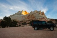
You will love everything on the Paria Plateau.. One of my favorite places.. Can't wait to see the TR & pics.

--------
Ok.... so we are going to White Pocket tomorrow via the long route (loaded into Gaia, we have maps too). We will most likely camp 1 night out there or at Stateline CG, because the meteor shower will peak Friday morning. I'm getting nervous about the sandy roads again, but we did well last week to Cottonwood cove, Coyote Butte South. We have a shovel, extra supplies, lots of water, etc. This off road driving has been a steep learning curve. We will leave early morning, when it's frozen like last week.


White Pocket Road (long route) is about the same as the long route to Cottonwood Cove. May Be a couple more sandy areas but should be fine for a 4x4. Park at the main area and don't go down the hill that goes past it. Have fun!
 
White Pocket Road (long route) is about the same as the long route to Cottonwood Cove. May Be a couple more sandy areas but should be fine for a 4x4. Park at the main area and don't go down the hill that goes past it. Have fun!
True.... After going past the main parking area on the left, there is a very sandy down hill... But... it has a very nice campsite on sandstone at the end. :twothumbs:
UTAH_2016-24.jpg
Here is my trip report from a couple of years ago..
 
We just came back after 24 hours at White Pocket, wow! Surreal! No problems driving, the Jeep and Rick did awesome. We had the route loaded in Gaia and we brought maps. There is lots of sand, it's more loose than Coyote Butte south a week earlier. We aired down the tires to 29-30psi before reaching the sandy roads.
We were alone for 1/2 day (blue sky), then suddenly there was about 15 people for sunset and late afternoon photos. When two "tour trucks" arrived, we returned to the parking for an early dinner and suited up for a cold evening. We got lots of blue hour shots and night shots. Got up at 2-3am and watched the stars and an awesome (!!!) meteor display, incredible.
It was 16F last night and this morning, that's chilly. :cold: We brought lots of wood, but there wasn't a fire ring anywhere. We didn't start a fire, what's the official rule or guideline for that ?
We stayed at main parking lot, just saw the posts above. Nobody else at night. The second parking area looks great, we passed it walking, looking for a fire ring.
 
Last edited:
Similar threads
Thread starter Title Forum Replies Date
SteveR Coyote Buttes South- New Daily Permit Process Trip Planning 8
S Driving to poverty flats (South Coyote Buttes) on AWD Trip Planning 11
Janice Vermillion Cliffs Trip - Part 2 - White Pocket & Coyote Buttes South Hiking & Camping 7
Janice The Wave - and SO MUCH MORE! (Coyote Buttes North, South, White Pocket, Buckskin, Condors, Bighorns...) - Part 1 Hiking & Camping 14
dhertbag Camping at Cottonwood Cove - Coyote Buttes South Trip Planning 11
Nick Coyote Buttes South - Jan 18, 2020 Trip Planning 1
pixie1339 White Pocket, South Coyote Buttes Advice Trip Planning 11
D Coyote Buttes South Paw Hole or Cottonwood Cove (or both) Trip Planning 3
SteveR Happy Canyon and Coyote Buttes South questions Trip Planning 4
chandlerwest South Coyote Buttes - Paw Hole Hiking & Camping 13
C white pocket hike, South Coyote Buttes Trip Planning 16
Scott Chandler Coyote Buttes South permits Trip Planning 8
D Late March 2013 trip to White Pocket, North and South Coyote Buttes Hiking & Camping 2
D South Coyote Buttes on a cloudy / rainy day Trip Planning 4
D Access Recommendations to Cottonwood Cove , South Coyote Buttes Trip Planning 3
IntrepidXJ Return to Coyote Buttes South Hiking & Camping 4
IntrepidXJ Coyote Buttes South Hiking & Camping 3
Nick Coyote Buttes South, January 2012 Hiking & Camping 4
John Fowler Coyote Buttes South Permit forecast Trip Planning 1
Kullaberg63 Suggestions for Escalante east of river, south of Choprock Trip Planning 4
Timber High Sierra - North Lake to South Lake Loop - Layover Day Trip Planning 9
J South Crandall Creek and the Hoodoos Wyoming and Yellowstone? Trip Planning 3
RockyMntCol Trip Planning Younts Peak / South Fork Yellowstone Trip Planning 12
F Thorofare/South Boundary/Wolverine Creek Trip Planning 2
balzaccom South America Everything Else 1
BobFink Yellowstone South Entrance to Fox Creek via Basin Creek Cutoff - Labor Day 2022 Trip Reports 4
scatman South Ridge of City Creek Canyon - January 28, 2023 Hiking & Camping 4
wsp_scott Big South Fork Bikepacking Backpacking 1
P Yellowstone--Heart Lake to South Entrance Backpacking 13
John Goering Tobacco Root Mountains South Meadow Creek Off Road 1
BJett Big South Fork National River & Recreation Area Packraft/Backpack Loop (TN) Backpacking 6
balzaccom South by Southwest from Napa Hiking & Camping 4
wsp_scott Honey Creek (Big South Fork) Backpacking 9
Chuck the Mauler Sierra North Lake / South Lake "loop" questions Trip Planning 10
wsp_scott Big South Fork Views Backpacking 14
S Conejos - South San Juan Wilderness Backpacking 2
Jammer Sequoia: Upper Kern and Lake South America Backpacking 12
kwc Chimney Mountain, South Central Adirondacks Hiking & Camping 3
kwc Hiking in the South Central Adirondacks Hiking & Camping 1
I Water in Frisky Creek south of Highway 12 in the Grand Staircase? Trip Planning 0
K Floating down South Fork of the Snake (ID) Trip Planning 1
regehr Dirty Devil South Trip Reports 14
TrailScot Quite the Adventure, South of Moab, Across the Colorado Plateau, May 2019 - Part 4 Backpacking 17
TrailScot Quite the Adventure, South of Moab, Across the Colorado Plateau, May 2019 - Part 3 Backpacking 8
TrailScot Quite the Adventure - South of Moab, Across the Colorado Plateau, May 2019 - Part 2 Backpacking 14
TrailScot Quite the Adventure - South of Moab, Across the Colorado Plateau, May 2019 - Part 1 Backpacking 10
regehr south waterpocket fold backpack Trip Planning 27
Titans Prescribed burn South Monroe Mountain- photos from Capitol Reef area Photography 0
Chuck the Mauler North Lake - South Lake questions Trip Planning 4
tropicalwanderer YNP : 8/31-9/7 : Heart Lake to Nine Mile via CDT, South Boundary and Thorofare Trip Planning 9

Similar threads

Back
Top