Slickhorn Canyon Access and Water

Jackson

I ❤️ GYE
.
Joined
May 31, 2015
Messages
3,208
I've got permits for 2 nights in Slickhorn Canyon in mid May, and my planned overall route is to go in at Slickhorn 1 and come out Trail Canyon (which is access 6 on the BLM map, I believe) with plenty of poking around for ruins, etc. Can anyone speak as to how difficult the descent into the canyon from TH 1 is? Sources I've read give varying perspectives. If I were going alone, I'd probably go headlong into it, but the group I'll be with only has a little bit of experience in Colorado Plateau hiking, scrambling, etc., so I'm willing to go in through a different tributary if needed.

And lastly, should I expect to find much water during mid May? I've read there's something resembling a permanent stream in at least one of the tributaries. However, looking at historical imagery on Google Earth, it appears that Slickhorn and its tributaries have been pretty dry in May before. I understand Google Earth isn't a definitive source for water reliability though. Haha.

Anyway, thanks for any help.
 
Once you get to the big pouroff, you just follow the bench to the South for around 1/2 mile. Then work your way down to the streambed. It is cairned fairly well.

It is steep, but I don't remember anything too hard. Maybe a section or two of steep slickrock. Maybe just bring a 30' piece of webbing for lowering packs.
 
Sounds like a great trip. Get the new Google Earth that comes with chrome. It's way better then the old one. Find Slickhorn on it and check the terrain real close. Is it slick rock or sand? Sand bad, rock good. Water is an X factor. Kind of late in my opinion.

Keep a back up plan. Watch the weather. I have used Google Earth to check for pools and it works but depends on the photo date of the pass. (Satellite that is.)

Sent from my E6810 using Tapatalk
 
I've tried slickhorn 1 before. We didn't go far enough apparently as there was an earlier access "trail" that was cairned straight to the bottom. Super steep so we decided not to go down it and bailed. Found out later the actual access was further along.
 
We day hiked Slickhorn 1 in October 2013, finding the route around the big pouroff reasonably well cairned, easy to follow on a beaten path where not on rock, and moderately steep and a bit loose for the drop off the bench to valley bottom. I recall maybe 1 or 2 short steeper "steps" on slickrock that should be ok with a group along to help pass down your heavier overnight packs. Or bring a short rope as previously suggested. Although we usually desert hike in light hikers, I might suggest a more supportive boot than most of that class of footwear- given the short but somewhat rugged descent route around the pouroff.
 
I've gone down Slickhorn 3 before, in April I think. Found water about 2/3 of the way down #3, and again at the confluence where all of #1-3 kinda come together at once. Below that, the canyon was dry. EDIT - I think there might have been some manky water near the confluence with Trail Canyon. The Author mentions it, but it's been a few years and I can't remember if I'm making it up or not. Don't expect any help from the rangers at Kane Gulch; canyon doesn't see enough traffic for them to get a water report.

It's a pretty brushy canyon, so bring long pants and your 'schwackin attitude. If you go downstream of Trail Canyon it starts to get a little bouldery.
 
Last edited:
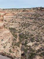
This photo shows the bench you will be walking on, the pouroff is off the photo to the left. You come down to the canyon bottom on the right side of the photo. The 2 darker grey sections of rock on the right side of the photo are the sections that you might need help with packs down.

The photo even shows a pool of water in the canyon, but this was taken in March.


slick.jpg
 
Thanks for the help, everyone. I really appreciate it. Great advice.

Sounds like the group should be able to handle it just fine, assuming we can find adequate water! I'll just be sure to pack a ton in case.
 
This photo shows the bench you will be walking on, the pouroff is off the photo to the left. You come down to the canyon bottom on the right side of the photo. The 2 darker grey sections of rock on the right side of the photo are the sections that you might need help with packs down.

The photo even shows a pool of water in the canyon, but this was taken in March.


View attachment 54297
Very helpful indeed! I can see why people get intimidated.
 
Similar threads
Thread starter Title Forum Replies Date
Bob Slickhorn Canyon System - 6 days Backpacking 22
mike_offerman Slickhorn Canyon Question Trip Planning 4
fossana Grand Gulch Pt 1 - Slickhorn 3rd to Trail Fork loop Hiking & Camping 6
LarryBoy A Slick Trip in Slickhorn Backpacking 7
DAA Todie, Slickhorn & Gravel Hiking & Camping 19
IntrepidXJ Slickhorn Perfect Kiva Hiking & Camping 4
J Reflection Canyon Trip Planning 3
fossana Found: prescription glasses near the top of the Flipoff Canyon approach General Discussion 5
Spud Salt Creek Canyon question Trip Planning 11
B Buckskin gulch/Pariah canyon Carpool Trip Planning 0
TractorDoc Paintbrush Canyon / Cascade Canyon Loop -- Grand Teton NP September 11, 2023 Hiking & Camping 9
Kullaberg63 15 day canyon route Backpacking 13
Titans Tricked in the canyon! Hiking & Camping 5
TrailScot Dayhiking the Under-the-Rim Trail - Bryce Canyon NP - October 2023 Hiking & Camping 4
Janice Such a GRAND Canyon - Deer Creek / Tapeats / Thunder River Backpacking 21
M Mee/Knowles Canyon Loop, Grand Junction Colorado Backpacking 4
OldBill Short hike at the Grand Canyon of Pennsylvania Hiking & Camping 1
S Paria Canyon- Whitehouse to Lees Ferry, Oct 18 to 21, 2023 Trip Reports 0
scatman Yellowstone's Thorofare, Headwaters of Thorofare Creek, Majo Pass, Younts Peak, Bob's Canyon, and Cub Creek - August 9, 2023 - Days 7 through 10 Backpacking 34
scatman Yellowstone's Thorofare, Headwaters of Thorofare Creek, Majo Pass, Younts Peak, Bob's Canyon, and Cub Creek - August 9, 2023 - Days 1 through 6 Backpacking 56
A Bowdie Canyon Trip Planning 10
TheMountainRabbit Silas Canyon (Popo Agie Wilderness) - August 2023 Backpacking 3
J Paria Canyon - One Day Trail Trip Planning 10
Bob The New Grand Canyon Trip Planning 1
WhozWutz Invite Horse Canyon Needles Meet Up (Members Only) 1
BJett Part 3 - Tour de Canyon Country. Lower Escalante Loop Hiking & Camping 0
BJett Part 2 - Tour de Canyon Country. Swell Times Hiking & Camping 0
BJett Part 1 - Tour de Canyon Country. Cedar Mesa. Hiking & Camping 8
Gretchen Millward Trachyte Creek via Woodruff Canyon, April 2023 Backpacking 9
F Grand Canyon hermits rest to granite rapids to bright angel Trip Planning 10
gnwatts Stillwater Canyon On The Water 11
shredhiker Kings Canyon July 2022 Kearsarge, Rae, & Sixty Lakes Backpacking 8
J Info needed: Bown's Canyon, Long Canyon Trip Planning 8
Gretchen Millward Cheesebox Canyon, Oct. 2022 Backpacking 14
Stickerbumper Fold Canyon Middle Exit Trip Planning 9
Janice Professor Creek / Mary Jane Canyon - mid April? Trip Planning 0
D Horseshoe Canyon or San Rafael Swell? Trip Planning 9
scatman North Ridge of City Creek Canyon - February 4, 2023 Hiking & Camping 17
scatman South Ridge of City Creek Canyon - January 28, 2023 Hiking & Camping 4
NorthwestWanderer 8 Day High Sierra trek : Humphreys Basin, Star Col, Granite Park, Lake Italy & Piute Canyon 6/25-7/2/22 Backpacking 7
T Amazing Discovery in Utah-Glen Canyon Trip Planning 65
Titans What’s your unfinished business? Hard canyon access, mtn peak, you name it! General Discussion 54
SteveR Big Spring-Elephant Canyon dayhike. With free bonus vacation pix! Hiking & Camping 13
Stephanie B Dirty Devil River Impassible at Poison Springs Canyon Off Road 0
LarryBoy Is there anything technical in White Canyon above the Black Hole? Trip Planning 16
dennisrodman A week in the Grand Canyon / Boucher / Hermit / Tonto Trail Trip Planning 4
XID_AZ Kanab Creek Wilderness - Sowats Canyon - Mountain Sheep Spring Trip Planning 6
travel2walk Yellowstone: Bechler Canyon, Aug 12-15 2022 Backpacking 21
balzaccom Mok Canyon Solitude for my birthday Backpacking 0
XID_AZ FiftyMile Canyon Sand slide Trip Planning 8

Similar threads

Back
Top