- Joined
- May 24, 2015
- Messages
- 179
Last year I hiked through the Ansel Adams Wilderness with one of my daughters in early August.
(Trip report here: https://backcountrypost.com/threads/high-sierra-lakes-tour.6295/#post-75048 )
My oldest daughter could not make that 2016 trip so I promised her a Sierra trip raincheck for the summer of 2017. Sierra 2016 had been a great trip with much more backcountry terrain left to explore so I decided to repeat the same cross country trip out of Agnew Meadows trailhead for 2017. I thought I would be smart and make the trip “perfect” by moving it back 10 days into late July to maximize the spring experience with more flowers and more snow in the higher elevations.
As is becoming our custom we drove straight from San Diego and broke up the trip by stopping and flopping our sleeping bags in the Alabama Hills located between Lone Pine and Whitney Portal. When we arrived at 1am I thought I would run down the dark and deserted trail to take a quick snapshot of the sky at Mobius Arch. To my surprise there was a professional photographer there at that late time in the night. He was taking time lapse photos once every 30 seconds and then his camera would travel a couple of millimeters up a rail that took up the entire tripod area. I had a good chat with him and eventually was able to get a picture of the milky way and see a sliver of moon rise.

I had to get to some quick sleep since we were also going to tour the arches starting before sunrise. This is my oldest daughter Kelley the next morning in my new favorite Mt Whitney photo.

There are more pictures of the arches in the camping forum here:
https://backcountrypost.com/threads/alabama-hills.6996/#post-83766
We picked up our permit and bear cans at the Inyo ranger station. I was hoping for the latest and greatest last minute information about the trail conditions from the rangers. They did not have any new information for us from anyone that had been on the trail. We had experienced the incredible record winter rain and snow that had hit the west coast, so we were well aware of that . We were also aware of the record snow melt that was continuing all through the Sierra. I was hopeful that the passes we had planned to travel over would be baking in the full sun and diminishing in snow cover each day.
The rangers did have some bad news, the road that connects the two ends of our hike was still in repair and therefore the Mammoth adventure shuttle was not running. If we kept with the plan that Holly and I did last year we would have added 4 miles of asphalt walking to the start of our trip and over 9 miles of uphill walking on asphalt on the last day. It was apparent our plans were going to be changed before we even got started thanks to the tremendous snowfall mother nature had dropped on the mountains between 2016 and 2017.
My longtime adventure partner Russ was also joining us with his college age son Will. That filled out our hiking permit.
While we were on the road Kelley got a call from a friend visiting from New Zealand. Fran was suddenly available to join us for her first Sierra trip also. She drove all night to the ranger station and was able pick up her own walk up permit easily.
It became evident that the road closure and unusual conditions were really impacting the normal day hikers that descend on Mammoth in the summer. The number of backpackers starting out on the trailhead was also impacted. Most of those we saw were coming in to resupply themselves from out on the John Muir trail or the Pacific Crest Trail, both of which paralleled our intended travels.
We started our hiking down the asphalt road to Agnew Meadows then got on the river trail.
There really are no river crossings of the Middle Fork of the San Joaquin on the trail. That was fortunate because the river was really flowing.
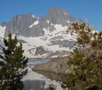
The trip was designed to maximize camp time and day hike time by making use of the high sierra passes to shorten our full pack milage and also put some distance away from the potential JMT and PCT crowds. Our destination was Thousand Island lake for the first night by way of the River trail. It would be our only long day at 12 miles. Mostly a gradual ascent but sometimes rather hot in the full summer sun.
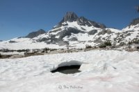
Towards the approach to the outlet of Thousand Island lake we started to cross some snow patches on the trail.

The Lake and surroundings were covered in a lot of snow for late July. When I saw this view for the first time I realized there was no way we were going to get to Lake Catherine as a day hike. It is a very remote Lake behind Mt Banner by way of the canyon in the right of this photo. We were not equipped with crampons and did not have the proper experience to go cross county across untraveled snow and ice.

We traveled pretty far west on the northern shore to get some isolation and find some patches that were not wet or snow covered for our camp. It did not take long for Holly to psych herself up and go for a brief dip.


I lost my breath just wading in up to my knees!
A marmot adopted us quickly and posed with all of our food in the bear canister.

That night I got lucky and caught a shooting star in one of my exposures. It was so quick I didn't believe my eyes. I was pretty happy when I got home and it was in there.
In the morning the landscape was loaded with cool panoramas. Unlike the previous flower year this year it was ice formations that were creatively scattered about.

It took a while but there were flowers to be found also.

At camp there was a buck with velvet antlers.

The plan for the day was supposed to be a day hike high up to Catherine Lake and also a recon of the pass we were supposed to pack over that afternoon. We could all see from a distance that the plan was not going happen but we all decided to go day hiking as far as we could before making any final decisions. This is a distant view of the pass in the far left of the photo that we needed to get over to continue our intended hiking agenda. Notice the pink watermelon snow on the surfaces facing the sun. Then notice where the slope gets too steep for the sun to make the watermelon algae grow. That was the part that concerned us.
As we hiked around the far end of the Lake we could see no real safe way to even start the hike to Lake Catherine. Too much snow and some of the streams would be hard to cross safely. So we hiked toward the pass to get a better look at it before making a decision that would affect the remainder of the trip. We came to a small stream and Fran decided she would wade across and do the recon for the group. She surprised us when she suddenly handed us back her boots, crossed the stream and continued onto the other side barefoot. She was like a frisky pony romping across the snow, the tundra and the forest, out of sight in a flash.
Fran crossing the distant snow patch on the right, barefoot.
Kelley explained that Fran had grown up on a NZ ranch and went barefoot almost her entire time at home.
She traveled really far out of our sight for better views of the path to the pass and then came back across the stream with a huge smile of satisfaction.

While she was away we realized that we probably could get across this pass with a careful lateral traverse but the next pass would be a lot more treacherous . We decided to change our plans by turning around and to backpack the conventional JMT trail back to Garnet lake as our plan B for our second night. That decision inspired us to take a group picture at the turnaround point of our cross country efforts.

Fran completed the rest of the day, hiking barefoot.
We took down our camp. One of the most scenic I have ever had.

We headed back the way we had come but this time got on the JMT south. We stopped and swam at Emerald lake. The JMT was covered in snow above the lake. Here the girls are studying the traverse we would need to do to hike out.
JMT hikers carefully going north on the Emerald Lake traverse.

We did not want to have to wait in line to get across this area so we got up to the ridge line quickly once the track was cleared.
The snow was real soft and the tracks were deep.
The next beautiful lake came up quickly. Fran immediately took her pack off and it was obvious what she was going to do. I barely had my pack off and my camera out before she jumped in to Ruby Lake.

After a few more minutes of hiking we came to our first views of Garnet Lake.
When I saw this view I stopped calling it Garnet Lake and started calling it Thousand Iceberg Lake. We hiked down to the shore and discovered the trail around the west was impassable with snow and the western campsites were snow covered. We were fortunate to find enough room for our three tents at the shore. While we were setting up the shoreline was clogged with sheets of ice. Fortunately a slight breeze developed a short time later that pushed the ice across the lake and allowed us to bath and fish.
Will caught the biggest rainbow of the trip shortly after this.

Holly becoming part of the landscape.

The backdrop felt more like something in the alps.

or maybe the Dolomites. Here Russ and Will are making good use of their thermarest chairs. I need to get one of those, they look like they are worth their weight to bring along.

When it came time to leave we had a big snow patch to traverse right away.

Russ and I felt so much better with poles. There were lots of snow holes ready to collapse that we could find with a little probing.

The trail followed the JMT around Garnet Lake then up and over a short pass down to the next set of lakes. It was another very short hike . As we watched the early morning JMT hikers they all seemed to climb straight up a couple of patches of steep snow towards the pass. That started to concern us. Fortunately when we got to the steep sections Will and the girls had found ways around the snow and ice. The trail characteristics were changing daily.
At the pass before descending to Shadow and Ediza lakes we realized we had a lot of time available so we ate lunch. Then we broke up and did some scrambling without packs. Will , followed by the girls, was on top of this rock pile in no time.

We were advised that the backpack to Ediza lake had some deep stream crossings ahead so we decided to camp the final two nights at Shadow Lake and day hike up to Ediza Lake.
There were some nice cascades on the way down to Shadow lake.
At Shadow lake there were camping restrictions near the lake shore so we set up tents on the hillsides but spent most of our time near the water. This was the first lake that did not have any ice sheets in it. All of the girls caught their first trout of the trip at this lake.

We were practicing catch and release but I accidentally injured a rainbow and it bled to the bottom of the lake. The group decided we should retrieve it and make a meal out of it. Fran dove down and caught it again by hand.

We shared our shoreline rock with this resident garter snake.

Our final full day we day hiked up to Ediza lake. It was originally supposed to be our night three campsite so we were happy to at least be able to get to it for a lunch stop. The regular trail to the lake campsites had a high volume stream running through it but we were able to scramble around on the north side and avoid the ford completely.
Snow bridges on trail.

Final path up to the Ediza Lake outlet.

Ediza Lake shoreline

Yet another lake with ice in it that the girls felt compelled to jump in and out of.

Followed by another Garter snake that felt compelled to crawl under and in between all of us.

Heading back to our camp there was a long set of great water features. This log was placed perfectly to form a frothy blueish pool below it.


On our final night we spent most of our time on the shoreline rock to avoid the Mozzies ( Kiwi-speak for skeeters). We each added some fresh trout to our freeze dried dinners. We also learned that freeze dried guacamole is not too bad and easy to prepare. After dinner we watched the stars, milky way, satellites and shooting stars come out while lying on the warm perfectly sloped rock.


On the hike out the next day there were lots of day hikers coming in. We found out from them that the shuttle had started running again. Yay! Catching a ride with the shuttle would save us 4 miles of uphill hiking on a steep asphalt road.
Mariposa Lilly on hike out.

So my plan to improve last years trip had been completely overtaken by mother natures record snow dump and melt off. We ended up exploring and camping at four new lakes compared to last year. We only stayed at one campsite that was on our intended agenda but we adapted to the conditions and had a great time with the incredible snow and icy scenery put before us. The navigation challenges that the snow and ice produced created an added boost to everyones outdoor experience enjoyment. Hiking with Kelley for the first time since she was little was a great confirmation that I had done something right. Not only was she competent in the outdoors but also confident and she made good decisions. Mission accomplished on that parenting goal!
Mammoth Mountain coming into view.

Russ and Will had caught an earlier shuttle. Here are the girls waiting for the final lift to the parking lot.

More hiking pictures on my flickr page at:
https://www.flickr.com/photos/14821634@N05/albums
Thanks for watching.
Tim and the team.
(Trip report here: https://backcountrypost.com/threads/high-sierra-lakes-tour.6295/#post-75048 )
My oldest daughter could not make that 2016 trip so I promised her a Sierra trip raincheck for the summer of 2017. Sierra 2016 had been a great trip with much more backcountry terrain left to explore so I decided to repeat the same cross country trip out of Agnew Meadows trailhead for 2017. I thought I would be smart and make the trip “perfect” by moving it back 10 days into late July to maximize the spring experience with more flowers and more snow in the higher elevations.
As is becoming our custom we drove straight from San Diego and broke up the trip by stopping and flopping our sleeping bags in the Alabama Hills located between Lone Pine and Whitney Portal. When we arrived at 1am I thought I would run down the dark and deserted trail to take a quick snapshot of the sky at Mobius Arch. To my surprise there was a professional photographer there at that late time in the night. He was taking time lapse photos once every 30 seconds and then his camera would travel a couple of millimeters up a rail that took up the entire tripod area. I had a good chat with him and eventually was able to get a picture of the milky way and see a sliver of moon rise.
I had to get to some quick sleep since we were also going to tour the arches starting before sunrise. This is my oldest daughter Kelley the next morning in my new favorite Mt Whitney photo.
There are more pictures of the arches in the camping forum here:
https://backcountrypost.com/threads/alabama-hills.6996/#post-83766
We picked up our permit and bear cans at the Inyo ranger station. I was hoping for the latest and greatest last minute information about the trail conditions from the rangers. They did not have any new information for us from anyone that had been on the trail. We had experienced the incredible record winter rain and snow that had hit the west coast, so we were well aware of that . We were also aware of the record snow melt that was continuing all through the Sierra. I was hopeful that the passes we had planned to travel over would be baking in the full sun and diminishing in snow cover each day.
The rangers did have some bad news, the road that connects the two ends of our hike was still in repair and therefore the Mammoth adventure shuttle was not running. If we kept with the plan that Holly and I did last year we would have added 4 miles of asphalt walking to the start of our trip and over 9 miles of uphill walking on asphalt on the last day. It was apparent our plans were going to be changed before we even got started thanks to the tremendous snowfall mother nature had dropped on the mountains between 2016 and 2017.
My longtime adventure partner Russ was also joining us with his college age son Will. That filled out our hiking permit.
While we were on the road Kelley got a call from a friend visiting from New Zealand. Fran was suddenly available to join us for her first Sierra trip also. She drove all night to the ranger station and was able pick up her own walk up permit easily.
It became evident that the road closure and unusual conditions were really impacting the normal day hikers that descend on Mammoth in the summer. The number of backpackers starting out on the trailhead was also impacted. Most of those we saw were coming in to resupply themselves from out on the John Muir trail or the Pacific Crest Trail, both of which paralleled our intended travels.
We started our hiking down the asphalt road to Agnew Meadows then got on the river trail.
There really are no river crossings of the Middle Fork of the San Joaquin on the trail. That was fortunate because the river was really flowing.
The trip was designed to maximize camp time and day hike time by making use of the high sierra passes to shorten our full pack milage and also put some distance away from the potential JMT and PCT crowds. Our destination was Thousand Island lake for the first night by way of the River trail. It would be our only long day at 12 miles. Mostly a gradual ascent but sometimes rather hot in the full summer sun.
Towards the approach to the outlet of Thousand Island lake we started to cross some snow patches on the trail.
The Lake and surroundings were covered in a lot of snow for late July. When I saw this view for the first time I realized there was no way we were going to get to Lake Catherine as a day hike. It is a very remote Lake behind Mt Banner by way of the canyon in the right of this photo. We were not equipped with crampons and did not have the proper experience to go cross county across untraveled snow and ice.
We traveled pretty far west on the northern shore to get some isolation and find some patches that were not wet or snow covered for our camp. It did not take long for Holly to psych herself up and go for a brief dip.
I lost my breath just wading in up to my knees!
A marmot adopted us quickly and posed with all of our food in the bear canister.
That night I got lucky and caught a shooting star in one of my exposures. It was so quick I didn't believe my eyes. I was pretty happy when I got home and it was in there.
In the morning the landscape was loaded with cool panoramas. Unlike the previous flower year this year it was ice formations that were creatively scattered about.
It took a while but there were flowers to be found also.
At camp there was a buck with velvet antlers.
The plan for the day was supposed to be a day hike high up to Catherine Lake and also a recon of the pass we were supposed to pack over that afternoon. We could all see from a distance that the plan was not going happen but we all decided to go day hiking as far as we could before making any final decisions. This is a distant view of the pass in the far left of the photo that we needed to get over to continue our intended hiking agenda. Notice the pink watermelon snow on the surfaces facing the sun. Then notice where the slope gets too steep for the sun to make the watermelon algae grow. That was the part that concerned us.
As we hiked around the far end of the Lake we could see no real safe way to even start the hike to Lake Catherine. Too much snow and some of the streams would be hard to cross safely. So we hiked toward the pass to get a better look at it before making a decision that would affect the remainder of the trip. We came to a small stream and Fran decided she would wade across and do the recon for the group. She surprised us when she suddenly handed us back her boots, crossed the stream and continued onto the other side barefoot. She was like a frisky pony romping across the snow, the tundra and the forest, out of sight in a flash.
Fran crossing the distant snow patch on the right, barefoot.
Kelley explained that Fran had grown up on a NZ ranch and went barefoot almost her entire time at home.
She traveled really far out of our sight for better views of the path to the pass and then came back across the stream with a huge smile of satisfaction.
While she was away we realized that we probably could get across this pass with a careful lateral traverse but the next pass would be a lot more treacherous . We decided to change our plans by turning around and to backpack the conventional JMT trail back to Garnet lake as our plan B for our second night. That decision inspired us to take a group picture at the turnaround point of our cross country efforts.
Fran completed the rest of the day, hiking barefoot.
We took down our camp. One of the most scenic I have ever had.
We headed back the way we had come but this time got on the JMT south. We stopped and swam at Emerald lake. The JMT was covered in snow above the lake. Here the girls are studying the traverse we would need to do to hike out.
JMT hikers carefully going north on the Emerald Lake traverse.
We did not want to have to wait in line to get across this area so we got up to the ridge line quickly once the track was cleared.
The snow was real soft and the tracks were deep.
The next beautiful lake came up quickly. Fran immediately took her pack off and it was obvious what she was going to do. I barely had my pack off and my camera out before she jumped in to Ruby Lake.
After a few more minutes of hiking we came to our first views of Garnet Lake.
When I saw this view I stopped calling it Garnet Lake and started calling it Thousand Iceberg Lake. We hiked down to the shore and discovered the trail around the west was impassable with snow and the western campsites were snow covered. We were fortunate to find enough room for our three tents at the shore. While we were setting up the shoreline was clogged with sheets of ice. Fortunately a slight breeze developed a short time later that pushed the ice across the lake and allowed us to bath and fish.
Will caught the biggest rainbow of the trip shortly after this.
Holly becoming part of the landscape.
The backdrop felt more like something in the alps.
or maybe the Dolomites. Here Russ and Will are making good use of their thermarest chairs. I need to get one of those, they look like they are worth their weight to bring along.
When it came time to leave we had a big snow patch to traverse right away.
Russ and I felt so much better with poles. There were lots of snow holes ready to collapse that we could find with a little probing.
The trail followed the JMT around Garnet Lake then up and over a short pass down to the next set of lakes. It was another very short hike . As we watched the early morning JMT hikers they all seemed to climb straight up a couple of patches of steep snow towards the pass. That started to concern us. Fortunately when we got to the steep sections Will and the girls had found ways around the snow and ice. The trail characteristics were changing daily.
At the pass before descending to Shadow and Ediza lakes we realized we had a lot of time available so we ate lunch. Then we broke up and did some scrambling without packs. Will , followed by the girls, was on top of this rock pile in no time.
We were advised that the backpack to Ediza lake had some deep stream crossings ahead so we decided to camp the final two nights at Shadow Lake and day hike up to Ediza Lake.
There were some nice cascades on the way down to Shadow lake.
At Shadow lake there were camping restrictions near the lake shore so we set up tents on the hillsides but spent most of our time near the water. This was the first lake that did not have any ice sheets in it. All of the girls caught their first trout of the trip at this lake.
We were practicing catch and release but I accidentally injured a rainbow and it bled to the bottom of the lake. The group decided we should retrieve it and make a meal out of it. Fran dove down and caught it again by hand.
We shared our shoreline rock with this resident garter snake.
Our final full day we day hiked up to Ediza lake. It was originally supposed to be our night three campsite so we were happy to at least be able to get to it for a lunch stop. The regular trail to the lake campsites had a high volume stream running through it but we were able to scramble around on the north side and avoid the ford completely.
Snow bridges on trail.
Final path up to the Ediza Lake outlet.
Ediza Lake shoreline
Yet another lake with ice in it that the girls felt compelled to jump in and out of.
Followed by another Garter snake that felt compelled to crawl under and in between all of us.
Heading back to our camp there was a long set of great water features. This log was placed perfectly to form a frothy blueish pool below it.
On our final night we spent most of our time on the shoreline rock to avoid the Mozzies ( Kiwi-speak for skeeters). We each added some fresh trout to our freeze dried dinners. We also learned that freeze dried guacamole is not too bad and easy to prepare. After dinner we watched the stars, milky way, satellites and shooting stars come out while lying on the warm perfectly sloped rock.
On the hike out the next day there were lots of day hikers coming in. We found out from them that the shuttle had started running again. Yay! Catching a ride with the shuttle would save us 4 miles of uphill hiking on a steep asphalt road.
Mariposa Lilly on hike out.
So my plan to improve last years trip had been completely overtaken by mother natures record snow dump and melt off. We ended up exploring and camping at four new lakes compared to last year. We only stayed at one campsite that was on our intended agenda but we adapted to the conditions and had a great time with the incredible snow and icy scenery put before us. The navigation challenges that the snow and ice produced created an added boost to everyones outdoor experience enjoyment. Hiking with Kelley for the first time since she was little was a great confirmation that I had done something right. Not only was she competent in the outdoors but also confident and she made good decisions. Mission accomplished on that parenting goal!
Mammoth Mountain coming into view.
Russ and Will had caught an earlier shuttle. Here are the girls waiting for the final lift to the parking lot.
More hiking pictures on my flickr page at:
https://www.flickr.com/photos/14821634@N05/albums
Thanks for watching.
Tim and the team.
Attachments
Last edited:

")