Question on Death Hollow Approaches

KC

Member
Joined
May 27, 2015
Messages
6
I was hoping for some advice on doing Death Hollow. My group can’t do the big drop into Death Hollow from the Boulder Mail Trail coming from Boulder (too much exposure). I was wondering if there is less exposure coming from the opposite direction on the Boulder Mail Trail (coming from the town of Escalante and dropping into Death Hollow that way)?

Also, with regard to exiting Death Hollow, does anyone know if you can exit on Big Flat Rd. (aka BLM 107 and BLM 108) that is just southeast of where Death Hollow meets the Escalante River?

Thanks for advice on either issue!
 
Nope. If the BMT from the east is not okay, you'll have just as much trouble coming from the west, and not just at the drop into Death Hollow.

There is a 'sneak route' southeast of the confluence of Death Hollow and the Escalante, but it is not for the faint of heart. It makes the other routes look like a walk in the park in regard to exposure.
 
I was hoping for some advice on doing Death Hollow. My group can’t do the big drop into Death Hollow from the Boulder Mail Trail coming from Boulder (too much exposure). I was wondering if there is less exposure coming from the opposite direction on the Boulder Mail Trail (coming from the town of Escalante and dropping into Death Hollow that way)?

Also, with regard to exiting Death Hollow, does anyone know if you can exit on Big Flat Rd. (aka BLM 107 and BLM 108) that is just southeast of where Death Hollow meets the Escalante River?

Thanks for advice on either issue!
These things are super subjective, but I was just down there on Saturday and there's nothing that I would consider particularly sketchy. Yeah there's a couple places where if you fell off it'd end badly, but on the other hand, it'd be pretty hard to fall off. The chisel trail is probably 5 feet wide at its narrowest - plenty wide unless you happen to be a cement mixer rather than a human. YMMV

One thing you could try is hiking in hiking down the river from Escalante, hiking the 4 miles upstream to the confluence of DH and Mamie Creek, and then back down DH, down the Escalante to the route 12 bridge, and out. It'd be pretty much equivalent mileage-wise to the BMT route. Plus the coolest bit of Death Hollow IMO is the last 4-5 miles.

Thanks for the suggestions/advice everybody.

This trip report did the hike counter-clockwise, starting in Escalante.

http://www.acrossutah.com/map/2008DeathHollow.htm

He describes the climb out of Death Hollow toward Escalante as not too sketchy. Also, the WOW Union Canyon Country book talks about the steep drop into Death Hollow from Boulder, but doesn't seem to say as much about climbing out of Death Hollow toward Escalante. Like you said, these things are subjective, but I was hoping that the climb out toward Escalante would be a tad bit easier.

He is on this site, ask him for yourself. @Jammer

In my opinion, neither side is very sketchy, but if the east is an issue, so is the west.
 
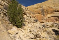
Definitely subjective based on experience, but my inexperienced friend joined me on that hike and he didn't have any problems at all. The steepest part is down low and is actually in chiseled/broken rock (pic below). Higher up it is open/rounded slickrock, but it's not as steep.

I haven't done the eastern part of the BMT or the Sneak Route so I can't compare (though from what I've read, I definitely would say stay away from the Sneak Route if anyone in the group has a fear of falling.) Also note -- most steep routes look far worse from a distance (and often in photos).

Do you have examples of what you (or your group) have done? Maybe something that caused stress re: exposure/steepness?

Shot of the route climbing out to the west:

BMT_west1.jpg
 
Definitely subjective based on experience, but my inexperienced friend joined me on that hike and he didn't have any problems at all. The steepest part is down low and is actually in chiseled/broken rock (pic below). Higher up it is open/rounded slickrock, but it's not as steep.

I haven't done the eastern part of the BMT or the Sneak Route so I can't compare (though from what I've read, I definitely would say stay away from the Sneak Route if anyone in the group has a fear of falling.) Also note -- most steep routes look far worse from a distance (and often in photos).

Do you have examples of what you (or your group) have done? Maybe something that caused stress re: exposure/steepness?

Shot of the route climbing out to the west:

View attachment 43860

Thanks for the photo and description. That is really helpful. We dropped into Fortymile Gulch last year; once we found the easiest route, there weren't any problems.

http://backcountrypost.com/threads/entering-forty-mile-gulch.3068/#post-57074

We didn't like the first bit of the Grandview Trail in Grand Canyon. The trail was fine, but one wrong step and . . .

It sounds like we can handle the BMT into Death Hollow. If not, we might just do the lower section from the Escalante River. But I'm not a big fan of out-and-back hikes, so we might give the BMT version a shot. Thanks again!
 
I just did Death Hollow, and I wouldn't consider any part of it "sketchy." That said, it is steep, and it was much better going down than up!!
 
Also, please post questions like this in the trip planning section, not the trip report section. Glad to have you on BCP
 
Similar threads
Thread starter Title Forum Replies Date
J Will be in Death Hollow in 2 weeks, had a question...... Trip Planning 28
Spud Salt Creek Canyon question Trip Planning 11
Outdoors24 Backcountry Tire Question General Discussion 12
kwc Southern Utah Accommodations Question General Discussion 10
swmalone Question about Garmin Inreach Send/Track Gear 11
AKay09 Rawah Wilderness Fire Question Trip Planning 3
Christo Yellowatone Permit question... General Discussion 16
IlVagabondo Yellowstone Camping Question General Discussion 13
B Uintas question Hiking & Camping 3
P Question about fording rivers in Yellowstone Trip Planning 10
Dhuff3243 Nooby with a question Noobs: Introduce yourself! 4
P Question about going around Shoshone Lake in Yellowstone Trip Planning 0
kwc Canada road tripping Northwest Territories question(s) General Discussion 2
U Maze District of Canyonlands question Trip Planning 15
swmalone GSENM Camping Question Trip Planning 37
Miya Noob Question about Hiking in the Snow General Discussion 32
O Green River/Stillwater Canyon question regarding water Trip Planning 3
Miya Bear Canister Noob Question Gear 27
Outdoors24 Gaia GPS question General Discussion 5
T RMNP sleeping pad question- mid July Trip Planning 4
Kelley Another Sleeping Pad question. Gear 5
Jackson Question about Deer Creek Trip Planning 2
R GPS Question Gear 13
B Upgrading Big Agnes tent question Gear 10
P Question about lighters General Discussion 5
C Denali day hike question Trip Planning 10
McKee80 dynamic range exposure question Photography 30
swmalone Question about Moab Canyoneering Trips/Guides General Discussion 8
swmalone Question about REI Garage Sales General Discussion 9
P Bears and hyperphagia and hiking question General Discussion 9
JDWalters Canyonlands/ Needles District question Trip Planning 5
JDWalters Escalante question General Discussion 12
Stevebo Yellowstone Question Trip Planning 19
Perry Dumb Question of the Day: Where is the northern gate on the Mirror Lake highway General Discussion 4
Perry Question About Number In Red Shown At Top of Main Page Questions, Suggestions & Support 2
regehr Granite Creek / Ibapah question Trip Planning 4
Bailey Question about Buckskin Gulch, Paria Canyon Backpacking 9
DrNed White Rim Trail - Fort Ruin Question Trip Planning 4
swmalone Question Regarding Trail Running Shoes Gear 2
Chuck the Mauler Convenient camp location question. Trip Planning 8
kimbur96 Question on star photography Photography 3
Vegan.Hiker Question about low light shooting Photography 8
Papa Dave Greetings! And one quick question Noobs: Introduce yourself! 1
Kullaberg63 Horseshoe Canyon question - complete descent, non technical Trip Planning 1
mike_offerman Slickhorn Canyon Question Trip Planning 4
Parma Copper Spur Question General Discussion 14
Joey Air pads and mildew question. Gear 26
BJett Question for you Rokinon FE14M-C 14mm F2.8 users... Photography 16
regehr Causey salmon run question General Discussion 3
steve Google Maps Engine Question on windows 8.1 laptop with USB gps General Discussion 0

Similar threads

Back
Top