Question on Death Hollow Approaches

KC

Member
Joined
May 27, 2015
Messages
6
I was hoping for some advice on doing Death Hollow. My group can’t do the big drop into Death Hollow from the Boulder Mail Trail coming from Boulder (too much exposure). I was wondering if there is less exposure coming from the opposite direction on the Boulder Mail Trail (coming from the town of Escalante and dropping into Death Hollow that way)?

Also, with regard to exiting Death Hollow, does anyone know if you can exit on Big Flat Rd. (aka BLM 107 and BLM 108) that is just southeast of where Death Hollow meets the Escalante River?

Thanks for advice on either issue!
 
Nope. If the BMT from the east is not okay, you'll have just as much trouble coming from the west, and not just at the drop into Death Hollow.

There is a 'sneak route' southeast of the confluence of Death Hollow and the Escalante, but it is not for the faint of heart. It makes the other routes look like a walk in the park in regard to exposure.
 
I was hoping for some advice on doing Death Hollow. My group can’t do the big drop into Death Hollow from the Boulder Mail Trail coming from Boulder (too much exposure). I was wondering if there is less exposure coming from the opposite direction on the Boulder Mail Trail (coming from the town of Escalante and dropping into Death Hollow that way)?

Also, with regard to exiting Death Hollow, does anyone know if you can exit on Big Flat Rd. (aka BLM 107 and BLM 108) that is just southeast of where Death Hollow meets the Escalante River?

Thanks for advice on either issue!
These things are super subjective, but I was just down there on Saturday and there's nothing that I would consider particularly sketchy. Yeah there's a couple places where if you fell off it'd end badly, but on the other hand, it'd be pretty hard to fall off. The chisel trail is probably 5 feet wide at its narrowest - plenty wide unless you happen to be a cement mixer rather than a human. YMMV

One thing you could try is hiking in hiking down the river from Escalante, hiking the 4 miles upstream to the confluence of DH and Mamie Creek, and then back down DH, down the Escalante to the route 12 bridge, and out. It'd be pretty much equivalent mileage-wise to the BMT route. Plus the coolest bit of Death Hollow IMO is the last 4-5 miles.

Thanks for the suggestions/advice everybody.

This trip report did the hike counter-clockwise, starting in Escalante.

http://www.acrossutah.com/map/2008DeathHollow.htm

He describes the climb out of Death Hollow toward Escalante as not too sketchy. Also, the WOW Union Canyon Country book talks about the steep drop into Death Hollow from Boulder, but doesn't seem to say as much about climbing out of Death Hollow toward Escalante. Like you said, these things are subjective, but I was hoping that the climb out toward Escalante would be a tad bit easier.

He is on this site, ask him for yourself. @Jammer

In my opinion, neither side is very sketchy, but if the east is an issue, so is the west.
 
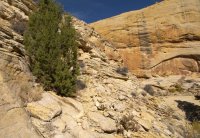
Definitely subjective based on experience, but my inexperienced friend joined me on that hike and he didn't have any problems at all. The steepest part is down low and is actually in chiseled/broken rock (pic below). Higher up it is open/rounded slickrock, but it's not as steep.

I haven't done the eastern part of the BMT or the Sneak Route so I can't compare (though from what I've read, I definitely would say stay away from the Sneak Route if anyone in the group has a fear of falling.) Also note -- most steep routes look far worse from a distance (and often in photos).

Do you have examples of what you (or your group) have done? Maybe something that caused stress re: exposure/steepness?

Shot of the route climbing out to the west:

BMT_west1.jpg
 
Definitely subjective based on experience, but my inexperienced friend joined me on that hike and he didn't have any problems at all. The steepest part is down low and is actually in chiseled/broken rock (pic below). Higher up it is open/rounded slickrock, but it's not as steep.

I haven't done the eastern part of the BMT or the Sneak Route so I can't compare (though from what I've read, I definitely would say stay away from the Sneak Route if anyone in the group has a fear of falling.) Also note -- most steep routes look far worse from a distance (and often in photos).

Do you have examples of what you (or your group) have done? Maybe something that caused stress re: exposure/steepness?

Shot of the route climbing out to the west:

View attachment 43860

Thanks for the photo and description. That is really helpful. We dropped into Fortymile Gulch last year; once we found the easiest route, there weren't any problems.

http://backcountrypost.com/threads/entering-forty-mile-gulch.3068/#post-57074

We didn't like the first bit of the Grandview Trail in Grand Canyon. The trail was fine, but one wrong step and . . .

It sounds like we can handle the BMT into Death Hollow. If not, we might just do the lower section from the Escalante River. But I'm not a big fan of out-and-back hikes, so we might give the BMT version a shot. Thanks again!
 
I just did Death Hollow, and I wouldn't consider any part of it "sketchy." That said, it is steep, and it was much better going down than up!!
 
Also, please post questions like this in the trip planning section, not the trip report section. Glad to have you on BCP
 

Don't like ads? Become a BCP Supporting Member and kiss them all goodbye. Click here for more info.

Back
Top