Pictured Rocks National Lakeshore

Curt

Member
Joined
Feb 1, 2014
Messages
418
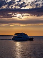
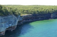
My wife has been wanting, for a long time, for us to take a trip to Michigan's Upper Peninsula. And for a long time I've been resisting this. Having grown up in the desert it's just been hard to get excited about a trip to a landscape covered with trees where everyday there is a possibility of rain. But I finally relented and off we went. It turned out to be a lot more interesting than I expected. The highlight of the trip was a visit to the "Pictured Rocks National Seashore". We were seeing this on the map and picked up some brochures in a motel and decided on a lark to sign up for a sunset cruise. Pictured Rocks is run by the National Park service. Although its not a National Park, it feels like one. Pictured Rocks runs for 40 miles along the south shore of Lake Superior between Munising and Grand Marais Michigan. It extends about 5 miles inland along the 40 mile length. There are hiking trails running the length of the coast and we saw several hikers. If you go hiking be prepared for bugs - biting flies by day and mosquitoes by night. A head net would be a good idea after sundown. A person could also make a trip by kayak or canoe and we saw a number of people doing this. A person would need to be careful to keep an eye on the weather going on the water. It may be one of the most dangerous coastlines in the world. There have been about 350 ship wrecks in storms since 1800 near this coast in the 70 miles between Munising and White Fish Bay.

The western half of Pictured Rocks consists of sandstone cliffs. The eastern half consists of dunes and we did not visit that half.

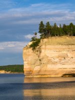
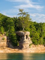
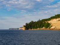
The pinnacle on the point in the foreground is called "Miner's Castle".
P7044224.jpg

P7044356.jpg

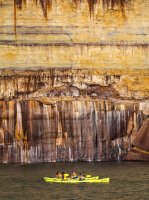
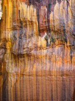
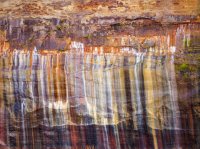
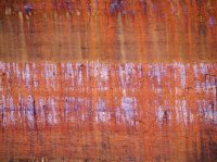
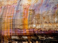
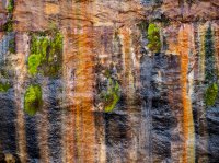
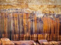
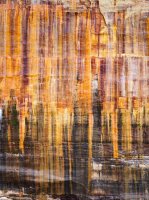
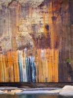
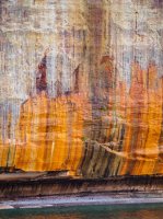
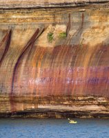
The mineral stains on the sand stone cliffs for which Pictured Rocks is named are due to ground water containing dissolved minerals seeping through the surface of the rock leaving the dissolved minerals behind. Most of the stains are quite large. Some of it looks a little like a Jackson Pollock painting.
P7044238.jpg

P7044246.jpg

The colors are amazing and quite varied.P7044455.jpg
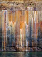
P7044439.jpg

P7044448.jpg

P7044480.jpg

P7044483.jpg

P7044476.jpg

P7044443.jpg

P7044469.jpg

P7044463.jpg

P7044460.jpg

P7044458.jpg

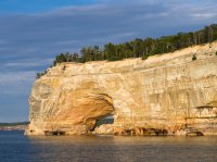
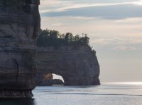
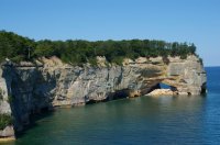
Wave action against the soft rock has excavated caves, arches, and pinnacles along the coast line.
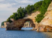
P7044290.jpg

P7044345.jpg

P7044354.jpg

P7044362.jpg

P7044287.jpg

P7044404.jpg

P7044372.jpg

P7044461.jpg

P7044507.jpg
 
Great photo's. I love the vivid colors.
Thanks! We were pretty amazed by the cool colors. The funny thing about that is that almost of all of the pictures I posted of the stained rocks were taken on the way back when everything was in the shade. Invariably the pictures taken when the rocks were in the shade, or when it was cloudy, had better colors than the ones taken when they were in sunlight. I would have expected the opposite.
 
This looks amazing Curt. I wonder if it's possible to cache a kayak somewhere so you can backpack the coast and paddle back.
 
Those are beautiful patterns on the rocks. I may have to add it to my list of places to visit.
 
Wow!! How beautiful is this place!! Too many damn places in the world I gotta see! Thanks for this eye opener.
 
Love that place! I was just up there for a four day weekend July 7-10 and hiked the Chapel Loop, ends up being 11.5 miles and traverses the tops of the cliffs in your photos. H-58 through the park used to be old 2 track logging roads, they paved it in 2010 which made it an amazing motorcycle road but really has changed the feel of the area and made it really hard to get a campsite through there. Cool seeing from water level, thanks for the photos!
 
This looks amazing Curt. I wonder if it's possible to cache a kayak somewhere so you can backpack the coast and paddle back.
There are two beaches along the western half where the cliffs are. Both are pretty large beaches and I think it would certainly be possible to pull in and leave a kayak to do some hiking/backpacking. The first is about halfway along the cliffs. The second is a couple miles from where the dunes start. That middle beach would probably be a pretty prime place to use a base a base to do what you're thinking about. The National Park Service has a basic map on their web page for Pictured Rock but it would give you an idea what the possibilities are.
 
From a Michigander to desert transplant, there are definitely some great places to explore in Michigan. You picked one of the better ones for sure. Lake Superior is pretty rugged. Some great coast on Lakes Michigan and Huron too (but mostly on the Canada side).
I've gone the other direction - grew up in the desert and have been transplanted to the midwest. I honestly didn't expect much but the whole trip in the U.P. was a lot better than I expected. I didn't say anything about one of the most interesting aspects of this trip for me and it was quite unexpected. That is the people in the U.P. I grew up in rural New Mexico. There was a literal hippie commune a quarter mile from my house and the general make-up / attitude of people from my childhood home is something I rarely see but recognize immediately when I see it. I saw it in the U.P. and it strangely felt like home. Not quite as extreme as my childhood home but definitely there. I enjoyed your home state. Thanks for your comments.
 
There are two beaches along the western half where the cliffs are. Both are pretty large beaches and I think it would certainly be possible to pull in and leave a kayak to do some hiking/backpacking. The first is about halfway along the cliffs. The second is a couple miles from where the dunes start. That middle beach would probably be a pretty prime place to use a base a base to do what you're thinking about. The National Park Service has a basic map on their web page for Pictured Rock but it would give you an idea what the possibilities are.

They are the most popular camp sites along the 62 mile length of the national lakeshore. You can actually create a loop from the TH...more like a triangle. It's an incredible hike! One of the best in the entire Midwest. I've done that hike 3 or 4 times and it never disappoints! Thanks for sharing.

Here's a view from the top.....#5 155.JPG #5 165.JPG #5 175.JPG #5 209.JPG #5 171.JPG
 
First, thanks for posting all the nice pictures. I lived near Pictured Rocks until two years ago, when I got the opportunity to move to the Yellowstone area. While I love Yellowstone, I love PIctured Rocks, too, and spent many days and nights there.

Second, someone suggested stashing a kayak at one of the two "western" beaches. Those would be Mosquito Beach (not as mosquito-ey as it sounds, usually), and Chapel Beach. Those are beautiful and popular, and would be nice to base-kayak from, BUT, if you look at the park map, there's an inland area that you can drive to. There's a small lake with a small drive-in campground (sometimes you can get one of the 8-12 sites--maybe there are more, but I doubt it), on Little Beaver Lake. Folks with boats put in there, paddle to the creek that connects Little Beaver to Beaver Lake, the follow the north shore of that lake to the outlet that is Beaver Creek. That wanders about to Lake Superior, at Beaver Creek backcountry campsite. From there, you have maybe two miles of 12 mile beach to get to the start of the cliffs. And, you might have to contend with some log jams in Beaver Creek, but there have been many times I've camped at Beaver Creek and had folks show up with kayaks. You could easily get a backcountry site there to use as a base-camp. To get to Mosquito or Chapel Beaches, you'd have to paddle from Miner's Beach. You can certainly get there, but it's a very exposed area. There's a local outfitter that takes people on tours, and it scares a lot of people who understand the risks that the clients are being exposed to. If you really want to hike the whole thing, and then kayak back, you might want to give the outfitter Northern Waters a call. I'm guessing that he'd be willing to spot you your kayak, or hold it for you while you hiked. He's really knowledgeable about kayaking and the area and would probably ask you some questions about your skill level--he doesn't want you to die. There always was a transportation service, and I assume it's still going. I forget what the days were, but you'd call ALTRAN (Alger County Transportation?) and they'd pick you up at one of their end points and move you to the other end point. If you wanted to do it on one of their regularly scheduled trips, and I think there were three days a week at 9 am or so, then the cost was something like $10-15 per person. If you wanted to be transported at a different time or day, then it was a good deal more expensive, but it wasn't outlandish, just more. And where they would pick you up is not where Northern Waters is, but my guess is that the Northern Waters guy would be willing to work something out--it's a small town. If that's what you want to do, I'd recommend that you a) get a Pastie at Muldoons, b) drop off your boat at Northern Waters, c) get to the pickup site and get shuttled, then hike back to Munising. Eat your Pastie the first night. Mmmm. The trail's easy. Depending on the time you are there, there may be many bugs. When you get to Munising, get your boat and head back. Beware, it's exposed. There *about* 12-15 miles of cliffs, which are broken up by a few beaches, about 12-15 miles of beach, and about 12-15 miles of 200 foot high sand dunes. The sand dunes section would offer NO protection from waves or much of anything else. There is absolutely no road access or trail access durning the dune section. There is some road/trail access during the beach section, and one road point and a few trail points where there is access during the cliffs section. Oh, I mentioned Beaver Lake--there's a backcountry water/backpacking campsite there, and also one on Au Sable Lake. Au Sable doesn't offer access to Lake Superior.

Now I'm "Pictured Rocks"-sick. Thanks for all the nice pictures...
 
I've always saved a few bucks and had the owner of Superior Motel help with shuttles rather than pay the big guy up there who's not friendly to deal with IMO.....sorry, Tom.

As of 2 years ago you can simply rent your kayaks in Munising, drop them at a few different spots and hike back to Miners Beach if you like.

There's a good bit of info, @Pringles . Nice
 
Thanks, Chuck. Northern Waters isn't "the big guy." I'm trying to avoid naming names. :) It's good to know about Superior Motel--I lived close enough I never stayed at any of the motels. Now that I've moved away, I stop by on the way to visit where I used to live, and that might be a good place to know about.

It's such a beautiful place. I would leave a hiking schedule with my sister, and my brother-in-law could never understand why I went there so often. He spends all his time in his (big and beautiful) garden. I rather enjoyed being on top of a 200 foot high cliff, in the presence of the big lake. :)
 
Similar threads
Thread starter Title Forum Replies Date
Janice Pictured Rocks National Lakeshore in Michigan's Upper Peninsula Backpacking 6
Opi Pictured Rocks 2013 Hiking & Camping 10
Titans Fun shaped Rocks Photography 26
balzaccom Stacking Rocks General Discussion 1
NorthwestWanderer Goat Rocks attempt & Tahklak Lake Hiking & Camping 1
Stephanie B Behind the Rocks, Ken's Lake Faux Falls, U-Turn Canyon, Seven Mile Canyon, and Dark Angel Hiking & Camping 4
Vegan.Hiker Hopewell Rocks, Cape d'Or, Canada Everything Else 12
J Dayhikes GSENM, Cap Reef, Behind the Rocks: Deer Cr, Tanks, Sheets Gulch, Moab Rim Apr. 4 to 8, 2018 Hiking & Camping 0
Ugly It's just a bunch of Rocks... Hiking & Camping 13
Kullaberg63 Indecision Peak, Red Rocks, NV Hiking & Camping 0
Nick Escalante On The Rocks On The Water 42
Ben Gooding City of Rocks, Coyote Creek Hiking & Camping 10
Ross The Needles, Behind the Rocks and Goblin Valley area Hiking & Camping 5
Ross Poison Spider Mesa views of Behind the Rocks Trip Planning 3
Ross Invite Halls Creek Narrows.....(& perhaps Needles/Behind The Rocks) Meet Up (Members Only) 12
DownUnderNoel The Pilbara: Red dust, trees, rocks and holes in the ground Everything Else 12
Seldom Seen Anderson Church Rocks Hiking & Camping 7
BrettCottrell Seneca Rocks, West Virginia Hiking & Camping 7
Jammer Behind the Rocks Backpacking 10
slc_dan Hamburger Rocks via The Post -Capitol Reef- Backpacking 14
gnwatts Clik Elite rocks! General Discussion 0
Alison Desert Rocks- Moab 2012 General Discussion 0
TheMountainRabbit News Release: Yellowstone National Park increases protection for bears and visitor safety by implementing changes to two bear management areas General Discussion 16
scatman The Gallatin River, Bighorn and Fawn Passes, Yellowstone National Park - September 7, 2023 Backpacking 14
futurafree government shutdown effects on national forests? General Discussion 21
BJett Packrafting the Obed National Wild & Scenic River - Tennessee On The Water 1
fossana New Baaj Nwaavjo I'tah Kukveni National Monument General Discussion 4
J York Fire, Mojave National Preserve. Aug 2023 Resource Discussions 3
Janice Field Trip - Washington Post podcast about national parks General Discussion 0
I Rescue Creek - Yellowstone National Park - June 3, 2023 Backpacking 15
scatman Rescue Creek - Yellowstone National Park - June 3, 2023 Backpacking 56
TractorDoc Cuyahoga Valley National Park (again!) 06/04/2023 Hiking & Camping 6
TractorDoc Cuyahoga Valley National Park 05/28/2023 Hiking & Camping 20
scatman Rescue Creek - Yellowstone National Park Meet Up (Members Only) 19
D Need suggestions -Beaverhead-Deerlodge National forrest, and Phillipsburg, MT Trip Planning 5
Ted California couple killed in Yosemite National Park rockslide identified by park officials General Discussion 0
NorthwestWanderer Backpacking Grand Teton National Park : Fossil Pass,Fox Creek Pass,Indian Lake,Alaska Basin,Hurricane Pass,Ice Floe Lake,& Snowdrift Lake Backpacking 19
fossana New National Monument planned in Southern NV General Discussion 3
canadug Hiker death in Zion National park :( Hiking & Camping 32
F Frontenac National Park, Quebec, Canada Hiking & Camping 2
J Mojave National Preserve Monsoon Aug. 3, 2022 Trip Planning 2
scatman Shoshone Lake Lollipop Loop - Yellowstone National Park - July 24, 2022 Backpacking 63
Absarokanaut Flooding in Yellowstone National Park and Adjacent Areas of Montana Today June 13, 2022 General Discussion 82
Dreamer El Yunque National Forest Hiking & Camping 3
Rockskipper pay-for-bot-scanning services for National Park campsites - interesting comments General Discussion 1
BJett Big South Fork National River & Recreation Area Packraft/Backpack Loop (TN) Backpacking 6
norwegianxplorer 7 days backpacking Breheimen/Glacier Home National Park in Norway Backpacking 2
pstm13 Rocky Mountain National Park Mid June with Kids Trip Planning 7
pstm13 Rocky Mountain National Park Mid June with Kids Trip Planning 0
Rockskipper Application Period Open For 2023 Private River Trips Through Grand Canyon National Park General Discussion 0

Similar threads

Back
Top