Ben
Member
- Joined
- Sep 12, 2014
- Messages
- 1,873
I took this summer off to ride my motorcycle up to Alaska and do some backpacking along the way. I left in June, and after seeing some friends in the Seattle area i went to do some hiking on the Olympic Coast.
This was my best trip of the whole summer, which was a little bit of a bummer since it was the first. Every other hike fell a little short of how perfect every thing was on this one. Gorgeous sunsets every night, great weather, no rain, lots of new sights, good sense of isolation. No crowds. I loved it.
My girl friend's brother was living in Seattle then, and had a day off, so he came to spend some time at the coast with me before i started the actual backpack. We went and walked around Beach 2, and either 3 or 4 before he had to leave.
I still have my fingers crossed that too much is better than too little.
Hunter, Brittinei's brother, in the fog on the coast. It really was kind of ethereal.
Barnacles on the roots of a long washed up stump.


Sea foam bubbles.
Intact sand dollar.
And Hunter again.
Some sea birds.
Anemones in a pool.
I left Hunter in the after noon and rode the rest of the way up to Rialto Beach, across the Quillayute River from the small community of La Push. I got there with enough time left in the day to make it out near the Hole In The Wall and set up camp, about a mile and a half from the parking lot.
Here's looking at James Island across the mouth of the Quillayute River.

Some sea stacks in the distance looking up Rialto Beach.
Looking down the spit at the mouth of the Quillayute, James Island on the right, La Push on the left. I don't know if La Push has fire works every night, or just when i'm camped in sight of it, but this trip had fire works. Twice.
James Island.
Looking out from Rialto Beach as the sun goes down.


Some sea stacks. These ones were like four or five stories tall.


The next morning. Some times barnacles were in clusters like this.
I'm not sure what these guys were.
The Hole In The Wall. I walked right through it between tide pools.
A marker for the overland route for when the tide is in and the Hole is flooded. Having a map and a current tide table is absolutely necessary for this trip.
Sea star.

Anemone.

Looking back. James Island in the distance.
A snail.
An other arch where i stopped and ate lunch.
Looking out from the first overland bypass, avoiding some impassable cliffs.
The marker for that bypass.

A washed up buoy. There were so many of these washed up here. And lots of rope also. And a pretty good amount of other trash, basically any thing that floated. Bottles, pallets, flip flops, a soccer ball, so much stuff.
Looking back at the bypass. The tree left of the saddle is the one pictured above with the marker on it.

An other sea stack.
Looking down from one of the bypasses. I enjoyed these things. They were so simple, just a washed up rope tied off at the top of the climb. Made the whole thing doable.


Found this just a little higher above the beach near a camp site.
Wilson.

Looking at an other by pass. You can see a rope, and some boards that have mostly given way.
View from the top.
The Norwegian shipwreck memorial.

The beach there, low tide.
A ghostly colored slug.
Near the Norwegian memorial. There are camp sites in the trees here. There is also an old abandoned trail that goes to Lake Ozette. It's very rough, and over grown, and gets lost some times. I walked out it for an hour without coming in sight of the lake before i turned around.
Later.

I was sitting around out side my tent and i heard the strangest noise, like a jackhammer rhythm. A sea otter was pounding open a shell on it's chest with a rock.
The next day i continued up toward Cape Alava. I came across some whale bones. Vertebrae.
Scapula, or shoulder blade.
A fin.
Vertebrae and ribs.
And even the skull. You can see my shadow next to it.
More buoys. I enjoyed the color.
Crab.
An indication of just how many buoys i saw.
A rather old chain.

One link has opened.
Looking North.
Looking back.
One of the things i really enjoyed was the mixed hiking conditions. Some times open sand beaches, some times cobbles, some times boulders. Some times exposed rock like this.
An other tunnel to pass through.

Not uncommon to have the route look like this.
Or this.


I think this is a petroglyph near Wedding Rocks.
Ozette Island.
Bodelteh Islands.
Camp night three, at Cape Alava. I walked a little beyond here trying to make it to Point of Arches, but had to turn around a little short to avoid walking in the dark.
Tskawahyah Island, connected at low tide.
Nice reflection in the wet sand.
Bald eagle.
Point of Arches is some of those distant stacks. The ridge running behind every thing is Vancouver Island.
The Ozette River, an easy ford.
Barnacles.
Mussels.
An other small island.
An over land by pass.
This was as far North as i made it before i had to turn back.
I liked these boulders.
On the way back to camp, some islands. The point on the left is just the other side of the Ozette River.

Looking down one of the by passes. Some were rather steep.

The sun starts to go down as i'm walking back.

Vancouver Island on the horizon.

The next day i start retracing my steps back to the South. Tide's out.
White Rock. That's actually it's name.


I got here just a little late for the tide, and had to do a little bit of hand and foot on the rock to traverse above the water.
Looking back after making it past.


I finally found the deer that had been making all the prints. I actually saw three others, a doe with two fawns.
Random metal relic.
Less sand, more rocks.


An other reflection.
More cliffy islands. They're all over the place.
Hawk on a rock.


The sun starts to go down on night four.
Late light.


After a final gorgeous sun set i camped on the North side of the Hole In The Rock this time. I skipped my planned camp site and walked may be 19 miles this day to be closer to out the next morning.


The marker for the parking lot.
Total mileage for the trip was about 53 miles over four nights.
 http://caltopo.com/m/0K0N
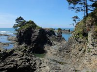
Featured image for home page:

This was my best trip of the whole summer, which was a little bit of a bummer since it was the first. Every other hike fell a little short of how perfect every thing was on this one. Gorgeous sunsets every night, great weather, no rain, lots of new sights, good sense of isolation. No crowds. I loved it.
My girl friend's brother was living in Seattle then, and had a day off, so he came to spend some time at the coast with me before i started the actual backpack. We went and walked around Beach 2, and either 3 or 4 before he had to leave.
I still have my fingers crossed that too much is better than too little.
Hunter, Brittinei's brother, in the fog on the coast. It really was kind of ethereal.
Barnacles on the roots of a long washed up stump.
Sea foam bubbles.
Intact sand dollar.
And Hunter again.
Some sea birds.
Anemones in a pool.
I left Hunter in the after noon and rode the rest of the way up to Rialto Beach, across the Quillayute River from the small community of La Push. I got there with enough time left in the day to make it out near the Hole In The Wall and set up camp, about a mile and a half from the parking lot.
Here's looking at James Island across the mouth of the Quillayute River.
Some sea stacks in the distance looking up Rialto Beach.
Looking down the spit at the mouth of the Quillayute, James Island on the right, La Push on the left. I don't know if La Push has fire works every night, or just when i'm camped in sight of it, but this trip had fire works. Twice.
James Island.
Looking out from Rialto Beach as the sun goes down.
Some sea stacks. These ones were like four or five stories tall.
The next morning. Some times barnacles were in clusters like this.
I'm not sure what these guys were.
The Hole In The Wall. I walked right through it between tide pools.
A marker for the overland route for when the tide is in and the Hole is flooded. Having a map and a current tide table is absolutely necessary for this trip.
Sea star.
Anemone.
Looking back. James Island in the distance.
A snail.
An other arch where i stopped and ate lunch.
Looking out from the first overland bypass, avoiding some impassable cliffs.
The marker for that bypass.
A washed up buoy. There were so many of these washed up here. And lots of rope also. And a pretty good amount of other trash, basically any thing that floated. Bottles, pallets, flip flops, a soccer ball, so much stuff.
Looking back at the bypass. The tree left of the saddle is the one pictured above with the marker on it.
An other sea stack.
Looking down from one of the bypasses. I enjoyed these things. They were so simple, just a washed up rope tied off at the top of the climb. Made the whole thing doable.
Found this just a little higher above the beach near a camp site.
Wilson.
Looking at an other by pass. You can see a rope, and some boards that have mostly given way.
View from the top.
The Norwegian shipwreck memorial.
The beach there, low tide.
A ghostly colored slug.
Near the Norwegian memorial. There are camp sites in the trees here. There is also an old abandoned trail that goes to Lake Ozette. It's very rough, and over grown, and gets lost some times. I walked out it for an hour without coming in sight of the lake before i turned around.
Later.
I was sitting around out side my tent and i heard the strangest noise, like a jackhammer rhythm. A sea otter was pounding open a shell on it's chest with a rock.
The next day i continued up toward Cape Alava. I came across some whale bones. Vertebrae.
Scapula, or shoulder blade.
A fin.
Vertebrae and ribs.
And even the skull. You can see my shadow next to it.
More buoys. I enjoyed the color.
Crab.
An indication of just how many buoys i saw.
A rather old chain.
One link has opened.
Looking North.
Looking back.
One of the things i really enjoyed was the mixed hiking conditions. Some times open sand beaches, some times cobbles, some times boulders. Some times exposed rock like this.
An other tunnel to pass through.
Not uncommon to have the route look like this.
Or this.
I think this is a petroglyph near Wedding Rocks.
Ozette Island.
Bodelteh Islands.
Camp night three, at Cape Alava. I walked a little beyond here trying to make it to Point of Arches, but had to turn around a little short to avoid walking in the dark.
Tskawahyah Island, connected at low tide.
Nice reflection in the wet sand.
Bald eagle.
Point of Arches is some of those distant stacks. The ridge running behind every thing is Vancouver Island.
The Ozette River, an easy ford.
Barnacles.
Mussels.
An other small island.
An over land by pass.
This was as far North as i made it before i had to turn back.
I liked these boulders.
On the way back to camp, some islands. The point on the left is just the other side of the Ozette River.
Looking down one of the by passes. Some were rather steep.
The sun starts to go down as i'm walking back.
Vancouver Island on the horizon.
The next day i start retracing my steps back to the South. Tide's out.
White Rock. That's actually it's name.
I got here just a little late for the tide, and had to do a little bit of hand and foot on the rock to traverse above the water.
Looking back after making it past.
I finally found the deer that had been making all the prints. I actually saw three others, a doe with two fawns.
Random metal relic.
Less sand, more rocks.
An other reflection.
More cliffy islands. They're all over the place.
Hawk on a rock.
The sun starts to go down on night four.
Late light.
After a final gorgeous sun set i camped on the North side of the Hole In The Rock this time. I skipped my planned camp site and walked may be 19 miles this day to be closer to out the next morning.
The marker for the parking lot.
Total mileage for the trip was about 53 miles over four nights.
http://caltopo.com/m/0K0NFeatured image for home page:
Attachments
Last edited: