- Joined
- Mar 11, 2022
- Messages
- 47
Hello everyone,
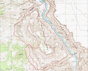
Below are some photos from a 4 day backpacking trip I did in May down and back up the Nankoweep trail, located in the northeastern corner of Grand Canyon NP. The original plan was to do a 4 day loop hike, exploring Nankoweep and Kwagunt canyons with a summit of Nankoweep butte along the way. However, after getting pummeled by the heat and trail during the long decent to Nankoweep creek, I shortened the trip to a simpler out and back from rim to river along the Nankoweep trail, with a much needed rest day on day two.
High and wild, I think the Nankoweep trail is a must do for the seasoned Grand Canyon hiker. Gone are the long mule trains and crowded campsites that you find along the main corridor routes. Instead you'll find 14 miles of primitive single track hiking down to the river, with gorgeous views, intriguing geology, and hardly another soul around for miles and miles. If you're looking for a more wild and primitive Grand Canyon experience with a trail, this is it.
With that said, the trail was much more difficult than I had planned for. From the car it was a long, dry 11 miles and 5000 ft. of elevation drop to my next water at Nankoweep creek. The last 3-4 miles from Tilted Mesa to Nankoweep creek was brutally hot in the late afternoon sun. I recommend carrying at least 6 quarts of water for this descent, and caching a quart of that water either at the NPS boundary or Marion point for the return trip back up. Fall or winter may be a better time to do this trip, especially if you are planning on taking several days to explore the lower canyon area. Note that access to the Nankoweep trail from the North Rim is closed from around December to mid May.
The Nankoweep trailhead is not accessible by road; you have to hike to it via another trail (trail #57). You can access this trail from the north, in the Saddle Mountain Wilderness area, which will lower your net elevation gain on the return trip by about 1000 ft. For those of you craving the true rim to river experience, you'll want to access trail #57 from the rim, inside of the national park, via forest road 610. This trailhead is at 8800 ft and is just north of Point Imperial - the high point along the North Rim in the NP.
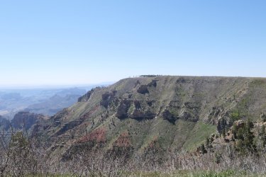
View of Point Imperial from the car at the North Rim access trail. It was a cool 60 degrees at the trailhead; you can still see pockets of snow at this elevation.
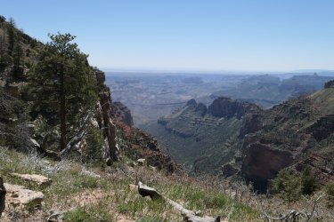
Looking down upper Nankoweep canyon from along trail #57
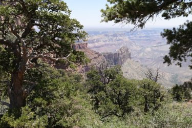
Looking southeast , near the Nankoweep/trail #57 trail junction. The Nankoweep trail contours along the Supai just below the prominent red cliff band, center of picture. Marion point (class 3 from the Nankoweep trail) is visible to the right.
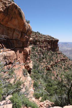
Near the beginning of the Supai traverse, along the Nankoweep trail. For 5 miles the trail contours along the strata at or near the base of the prominent upper cliff band in the picture all the way to Tilted Mesa. For me the traverse was not as scary as the NPS guide made it out to be. For the most part the strata that you are walking on along the base of the upper cliff band forms a ledge system 10-20 ft wide with minimal exposure and great views. In a few spots though, the ledge does narrow to about 5 ft across and things feel a little airy here. Thankfully, the trail is class 1 in these narrow sections with minimal obstacles to work around.
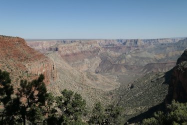
Along the Supai traverse, looking down towards Nankoweep creek about 4-5 miles away. My campsite and first water on the trail are visible to the left of the fork in the creek bed next to some dark colored rocks (Cardenas Basalts). The mighty Butte fault is clearly visible just past the campsite; Nankoweep butte is visible off to the right.
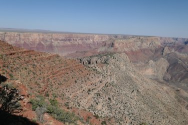
Near the end of the Supai traverse near the top of Tilted Mesa. The trail descends down the scree slopes on the right side of Tilted Mesa via a toe crushing, blister inducing set of steep switchbacks and traverses, all in full afternoon sun. You'll need trekking poles and a good pair of hiking boots to keep from sliding down the ball-bearing scree and debris in this section. I ran out of water near the top of the decent, complicating my situation further. By the time I reached water and the creekbed at dusk, I was in tatters. Somehow I managed to set up the tent, and after drinking 2 quarts of water and eating a late dinner, I passed out on top of my sleeping bag.
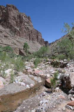
Nankoweep creek close to my campsite. After a much needed rest day nursing my blisters on day 2, on the third day of my trip I completed a day hike down Nankoweep creek to the Colorado river and back; roughly 6 miles round trip. Nankoweep creek was flowing all the way to the river with clear, silt free water that tasted great! Shade from the canyon walls and some pools that were just deep enough for soaking provided great places to rest and take in the views in this remote canyon.
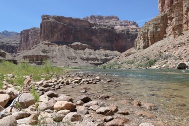
The Colorado river at Nankoweep. I spent about an hour here taking in and contemplating the scenery. The sudden change in view, the cool 45 degree water, and greeting the occasional rafting trip floating down the river provided an almost outworldly experience. I felt like the pioneer in the Twilight Zone episode who suddenly gets transported to the 1950s era diner. Here I was after hiking 15 grueling miles to reach this remote point, watching rafters float the river on rafts piled high with food and water! Of course I would have gladly had a beer with them, but the experience reminded me of the objective reality that only backpacking can seemingly provide to me.
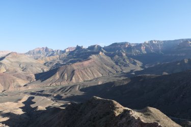
With about 5 quarts of water in my pack and a 5:30 am start, I began the ascent from my camp at Nankoweep creek back to my car on day 4. With all the difficulties I encountered on the way down, I was worried about having enough water (and endurance) to make it back to the rim and civilization. The plan was to get as far as I could through all of the scree on the lower part of the route before the sun hit the valley strong at around 9:30 am. Thankfully the pack was lighter and hiking up scree was much more straightforward than hiking down. I was also assisted by Mother Nature providing some high level cloud cover in the area till about 1 pm, which really helped me conserve water. With the extra quart of water that I cached near the NPS boundary on the way down, I made it back to the car with a cup or two of water to spare, and an incredible adventure to share! Thanks for viewing.
Below are some photos from a 4 day backpacking trip I did in May down and back up the Nankoweep trail, located in the northeastern corner of Grand Canyon NP. The original plan was to do a 4 day loop hike, exploring Nankoweep and Kwagunt canyons with a summit of Nankoweep butte along the way. However, after getting pummeled by the heat and trail during the long decent to Nankoweep creek, I shortened the trip to a simpler out and back from rim to river along the Nankoweep trail, with a much needed rest day on day two.
High and wild, I think the Nankoweep trail is a must do for the seasoned Grand Canyon hiker. Gone are the long mule trains and crowded campsites that you find along the main corridor routes. Instead you'll find 14 miles of primitive single track hiking down to the river, with gorgeous views, intriguing geology, and hardly another soul around for miles and miles. If you're looking for a more wild and primitive Grand Canyon experience with a trail, this is it.
With that said, the trail was much more difficult than I had planned for. From the car it was a long, dry 11 miles and 5000 ft. of elevation drop to my next water at Nankoweep creek. The last 3-4 miles from Tilted Mesa to Nankoweep creek was brutally hot in the late afternoon sun. I recommend carrying at least 6 quarts of water for this descent, and caching a quart of that water either at the NPS boundary or Marion point for the return trip back up. Fall or winter may be a better time to do this trip, especially if you are planning on taking several days to explore the lower canyon area. Note that access to the Nankoweep trail from the North Rim is closed from around December to mid May.
The Nankoweep trailhead is not accessible by road; you have to hike to it via another trail (trail #57). You can access this trail from the north, in the Saddle Mountain Wilderness area, which will lower your net elevation gain on the return trip by about 1000 ft. For those of you craving the true rim to river experience, you'll want to access trail #57 from the rim, inside of the national park, via forest road 610. This trailhead is at 8800 ft and is just north of Point Imperial - the high point along the North Rim in the NP.

View of Point Imperial from the car at the North Rim access trail. It was a cool 60 degrees at the trailhead; you can still see pockets of snow at this elevation.

Looking down upper Nankoweep canyon from along trail #57

Looking southeast , near the Nankoweep/trail #57 trail junction. The Nankoweep trail contours along the Supai just below the prominent red cliff band, center of picture. Marion point (class 3 from the Nankoweep trail) is visible to the right.

Near the beginning of the Supai traverse, along the Nankoweep trail. For 5 miles the trail contours along the strata at or near the base of the prominent upper cliff band in the picture all the way to Tilted Mesa. For me the traverse was not as scary as the NPS guide made it out to be. For the most part the strata that you are walking on along the base of the upper cliff band forms a ledge system 10-20 ft wide with minimal exposure and great views. In a few spots though, the ledge does narrow to about 5 ft across and things feel a little airy here. Thankfully, the trail is class 1 in these narrow sections with minimal obstacles to work around.

Along the Supai traverse, looking down towards Nankoweep creek about 4-5 miles away. My campsite and first water on the trail are visible to the left of the fork in the creek bed next to some dark colored rocks (Cardenas Basalts). The mighty Butte fault is clearly visible just past the campsite; Nankoweep butte is visible off to the right.

Near the end of the Supai traverse near the top of Tilted Mesa. The trail descends down the scree slopes on the right side of Tilted Mesa via a toe crushing, blister inducing set of steep switchbacks and traverses, all in full afternoon sun. You'll need trekking poles and a good pair of hiking boots to keep from sliding down the ball-bearing scree and debris in this section. I ran out of water near the top of the decent, complicating my situation further. By the time I reached water and the creekbed at dusk, I was in tatters. Somehow I managed to set up the tent, and after drinking 2 quarts of water and eating a late dinner, I passed out on top of my sleeping bag.

Nankoweep creek close to my campsite. After a much needed rest day nursing my blisters on day 2, on the third day of my trip I completed a day hike down Nankoweep creek to the Colorado river and back; roughly 6 miles round trip. Nankoweep creek was flowing all the way to the river with clear, silt free water that tasted great! Shade from the canyon walls and some pools that were just deep enough for soaking provided great places to rest and take in the views in this remote canyon.

The Colorado river at Nankoweep. I spent about an hour here taking in and contemplating the scenery. The sudden change in view, the cool 45 degree water, and greeting the occasional rafting trip floating down the river provided an almost outworldly experience. I felt like the pioneer in the Twilight Zone episode who suddenly gets transported to the 1950s era diner. Here I was after hiking 15 grueling miles to reach this remote point, watching rafters float the river on rafts piled high with food and water! Of course I would have gladly had a beer with them, but the experience reminded me of the objective reality that only backpacking can seemingly provide to me.

With about 5 quarts of water in my pack and a 5:30 am start, I began the ascent from my camp at Nankoweep creek back to my car on day 4. With all the difficulties I encountered on the way down, I was worried about having enough water (and endurance) to make it back to the rim and civilization. The plan was to get as far as I could through all of the scree on the lower part of the route before the sun hit the valley strong at around 9:30 am. Thankfully the pack was lighter and hiking up scree was much more straightforward than hiking down. I was also assisted by Mother Nature providing some high level cloud cover in the area till about 1 pm, which really helped me conserve water. With the extra quart of water that I cached near the NPS boundary on the way down, I made it back to the car with a cup or two of water to spare, and an incredible adventure to share! Thanks for viewing.
Last edited:

