- Joined
- Jun 25, 2012
- Messages
- 4,430
Objective: Wham Ridge, Vestal Peak - Grade III 5.6

This report is dedicated to the likes of @ram who showed that he could post a popular TR here involving adventure, suffering, climbing and even more suffering, and @Kullaberg63 who has demonstrated that you "don’t need no stinking trail”. You do not need to stick to the beaten path: if there is a long dirt road in the way put your bike in the mix, if there is a river blocking your route put your raft on the bike. If a cliff may be encountered put your rope on your raft on your bike on your back and carry all of it with your family including doggie off into the unknown. Kudos guys and props for doing it at an age where most people are slowing down or going home.
This report details this September's trip to clear a nemesis from my record. Being a driven person has led me to attempt and eventually succeed on many diverse life goals. Unfortunately some of these attempts have also ended in failure. The failed attempts that cause me the most angst are the long backcountry, technical rock climbs. These are my nemesis. They stick in my craw. I have been able to go back and repeat and complete most of these routes like on Charlotte Dome in the Sierra and Haystack Peak in the Wind Rivers. One of these nemesis that has stuck with me for 15 years is the Wham Ridge on Vestal Peak in the San Juan mountains of southwest Colorado. My partner Dan McCool and I climbed to 1/3 height on the route in August 17, 2000 when the monsoon skies opened up and sent us packing, saturated and defeated. This recount is of my clearing of this nemesis. My dear friends Jeff and Don joined me for this attempt. It wasn’t easy but it sure was rewarding.
And there I was, standing on a sloping ledge clipped in to three small pieces of metal anchoring me to the cliff, cold and tired. My two climbing bros Don and Jeff have left me alone at this belay ledge while they busily push the rope up the next pitch.
Old Man of the Mountain

I can hear those two way above me and out of sight, jawing happily about the trivial and the mundane. “Holy smokes, there is a lot of loose rock up here - we have to keep from knocking any killers down on Art.” “Oh, my feet are tired. Do you think we have much farther to go?” “I can still taste those sardines from lunch." etc. etc. etc.
We have been hiking and climbing since dawn and are maybe three-fourths of the way up the route. Although cold and tired I am content and optimistic that this nemesis is going to fall. I look around from this position in which I am temporarily stuck and am overwhelmed. My favorite position: on an artistically beautiful piece of rock in a delicate situation with ecstasy-inducing views surrounding me. I have to pee.
I first saw a grainy black and white picture of this peak in an old Colorado climbing guide 30 years ago. As I am want to do I said to myself “Holy Smokes, I am going to go climb (hike, ski, run) that rock! It is too beautiful to leave alone.” And so I did make an attempt on Wham Ridge 5 years later. I promptly failed. Rock climbing and rain-slickery rock do not mix. In another case I visited Alton, Utah due to a National Geographic article. I climbed Devil’s Tower because I saw it in “Close Encounters”. I rode my bike to Winslow, AZ because of the Eagles. And so it goes.
Climbing this route the way I choose to do it involves a fairly serious 4WD approach on old mining roads far above tree-line. It involves riding on a historic steam locomotive on a narrow-gauge railroad in the mountains in which they stop the whole train and drop your sorry butt off in the boondocks. It then involves backpacking in five miles and up nearly 3000’ feet to set a basecamp on what is euphemistically called a trail only by climbers. Only then do you get to start climbing.
Multimodal Travel Diagram:
My Bed >> Drive >> 4WD >> ChooChoo Train >> Backpack >> Climb Up >> Success << Climb down <<Backpack << ChooChoo Train << 4WD << Drive << My Bed
MAP
Click here to view on CalTopo
This rock climb ascends up the proud and wondrous Wham Ridge in the heart of the Winemuche Wilderness. This wilderness forms a large part of the San Juan Mountains of southwest Colorado. Specifically Wham Ridge is the north face of Vestal Peak in the Grenadier sub-range of the San Juans. The San Juan Mountains are the overall classification for a suite of sub-ranges including these Grenadiers.
The route requires addressing obvious logistical challenges. The weather is one of the big ones and the cause of my failure in 2000. We attempted the peak in August in the very heart of the monsoon. The San Juans enjoy copious precipitation caused by this southerly monsoonal flow. The plan for this attempt was to wait until mid-September and try the peak after the monsoon ended. The week before leaving for the start of this most-excellent adventure the monsoon was still going strong. This caused us to contemplate alternative sunny destinations - namely Mt. Coness in the Range of Light in northern Yosemite National Park. A few days before our departure however the forecast turned to 7 "orange balls". This is my short hand for high pressure setting in over southern Colorado due to the sun ball icons on the televised daily weather forecast. Time to vamoose!
Let’s get on with it.
Telluride on the 4WD approach - happened upon the annual film festival. We conducted the requisite inquiries into the Colorado smoke- house scene.

The road over the mountain - the Imogene Trail

Nearing the summit. 4Runner cheesecake shots.


San Juan’s mineralization make for amazing colors.

Rock Glacier

Box Canyon - an Ouray developed slot canyon attraction

Rarely-observed nesting American Black Swift (Cypseloides niger) in this slot canyon. There are only 150 known breeding sites in North America. This is one of them.

The infamous Gold King site - this summer’s environmental disaster that reddened the water all the way to Lake Powell

Our Ride

Running downstreaml along the Animas river.

Off-loading at the embarkation point

“Wait! I forgot my shoes!”

Our first view of our destination peak and Wham Ridge from the Colorado Trail. Vestal Peak, the furthest back and on the left, is our objective.

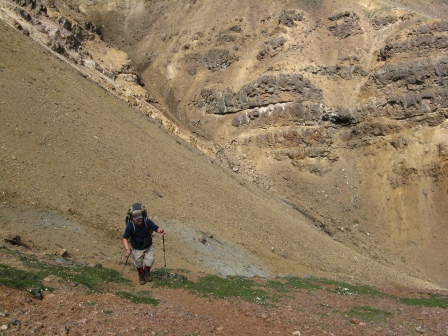
Jeff resting on "the trail” on the way up

Base camp in Vestal Creek meadows.

Vestal Peak from our dayhike before the climbing day. The smooth face on the right of the feature is Wham Ridge.

The full drainage from above our peak, Vestal. To the right of Vestal is Arrow Peak and to the right of it is the more rounded dome of Electric Peak.

Vestal Lake underneath the most easterly of the Trinity Peaks. Trinity One.

Jeff climbed to the pass on this “rest” day and shot this image of the full drainage.

Dawn. The start of our climbing day.

Alpen glow on, left to right, Trinity Three, Trinity Two, Trinity One and the promised land, Wham Ridge

The approach. Good to memorize the next couple of miles so we can reverse it - potentially in the dark.

The first sweet orange rays striking our objective and hopefully warming the rock up, and us.

Our “ridge” is mostly a smooth, glacially scoured and polished triangular face. Our route is drawn in with the benefit of hindsight.

Jeff and Don running and puffing up the start. The bottom was smooth and amazingly clean.

Jeff resting and inventing our path. Half the fun of backcountry rock climbing is the way-finding and half the stress.


A good perspective of the surprisingly low angle of the lower slabs at the start of the climb.

Now the wall begins to steepen. Not abruptly. You proceed and all of a sudden realize it is steep.

Time to rope up.

The first roped pitches were easy but time consuming. We had to spend time wandering around, back and forth, looking for a crack in which we could place protection. Would have been far faster to just solo. Especially because we were a team of three “dopes on a rope”.

The view down is improving. The ridge is steepening further and the rock is more and more broken.

Bringing Jeff up.

Don and Jeff fiddle-farting around with the belay and gear.

The view from the perch of the center section of the Grenadiers and the continental divide to the east.

The view to the northwest with other subranges of the San Juans in view.

I am alone. Clipped in to my perch listening to my bros above me having fun.

The light is improving. Shadows deepening. Contrast increasing.

Hey. WAIT A MINUTE! I snap out of my reverie, jerk erect and get my clock out my pocket. What time is it? 6:00 p.m. Damnation! I shout up to those two. “We are about to get benighted on this thing! Get a move-on!"
When climbing long routes in the backcountry I am filled with elation on summiting a peak but the relief does not kick in at that point. The stress is in no way relieved because the route finding, the difficulty and certainly the danger is often worse finding the way down. You are tired and in a hurry. You still have route finding to do and you are 4th-classing (climbing without use of roped protection) down which is harder than 4th class climbing up. And I am scared of the dark! Or, at least, scared of huddling - shivering on a cold ledge spooning with my two bros laying on our ropes for insulation. Time to accelerate.
We summit. Ruh Roh. I shout down to my belayers, “It’s a false summit”.
The view to the next and hopefully final summit.

Now we are really on top and can see that to continue on is to descend.

A few requisite hero shots from the summit. Don on top.

Jeff expressing jubilation on a peak hard earned.

Jeff gifted me an energy snack and behold, it is @Scatman’s elixir of recovery for backcountry pain and suffering. Honey Stinger.

The descent was quite sketch but we are motivated to hustle through it. After the worst of it this view shows better descending conditons but still steep and loose.

Shadows continue to deepen.

Arrow Peak from the Vestal/Arrow col where we are finally crossing back over to our side of the ridge after descending the opposite side from our camp and climb.

First view of the next part of the descent. Yuk. A boulder and talus field with sections of stacked huge boulders that we had to wend our way through. Unfortunately the first part is very steep.

Descent

More of the descent. At one point, mid-slope in this view Don tiredly dropped his guard, slipped and pitched forward doing two or three end-over-end rolls down the talus and dirt. As I ran over to him over the boulders he sat up and cursed so I knew he was going to be OK. Several bad bruises and minor cuts were the result and a delay. Now we knew we were going to be be-nighted.

Looking up at the side of Wham Ridge as we blew by.

The rest of the descent was convoluted and the increasing darkness made navigation more difficult. We encountered some very steep moraine slopes that were too dangerous to descend. People die from boulders rolling down on top of them when they attempt to descend at the angle of repose.
Luckily we wended our way through the worst of this with the last of the fading dusk light. We turned on our headlamps as we got onto the steep dirt and then the climbers trail trough the alpine bushes and, finally, the forest. As we stumbled back to camp climbers not far from the trail yelled out that they watched us climb all day and descend by headlamp to this point. “Great work in getting it done!” they said. Yeah, no kidding.
Home by about 11pm after starting walking at around 6. A full day. A nemesis cleared. A deep sense of relief and satisfaction.
I slept well after a quick dinner and a little scotch with my pickle juice at my side for cramps.
Our legs really protested picking up these massive climbing and camping packs to walk out. Thank you! mr. meadow for providing us a place to rest this week of adventure and strain.

Interesting mushrooms on the walk out.

Not the easiest “trail” to walk out on the next day.

This is berry and grub country. Bear country. We did see several medium piles of scat back there. There are only black bears in the San Juans. So far the browns have not returned. The San Juans were the location of the last grizzly bear killed in the lower 48 until we came to our senses and started helping them back to their environment. I may have that memory wrong. It may be the location of the last bear in Colorado and not the last in all of the 48 - I will have to go look it up.

Interesting fungi on a cut log end on the Colorado Trail.

Autumn Approacheth

The Animas River

Some of this orange is normal mineralization and much of it was left by the flood of debris and contamination from the Gold King.

Our ride.

Trudging to our next mode of transportation in Silverton. I count this as segment nine of our adventure travails. But this is one of the most important - head/feet wash, beer and snacks are in the truck.

The Grenadiers from the road drive from Silverton south to Durango. The Grenadiers and Wham Ridge are in view. See it?

Adios Nemesis!
- The End (thanks for reading along)
Featured Image for Home Page

Last edited:
")