- Joined
- May 24, 2015
- Messages
- 175
Part One:
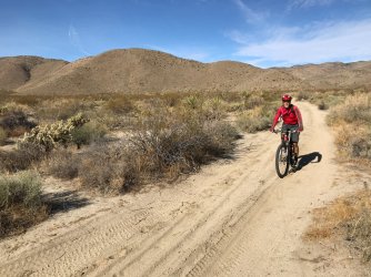
My buddy Chris and I, were looking for a good, full day ride, when Chris found a description in his mountain biking book for a ride that went thru the heart of the Anza Borrego state park. The town of Anza is at 4000 feet and is located in California's Riverside county. An abandoned jeep road descends out of town into Anza Borrego state park and connects to Borrego Springs at sea level, 30+ miles later. This seemed like an ideal ride for us to do, in the desert, in late fall. It would take me thru some upper parts of Coyote Canyon that I had never seen before and it would be downhill, making it easier to pedal thru the sand that we were bound to encounter.
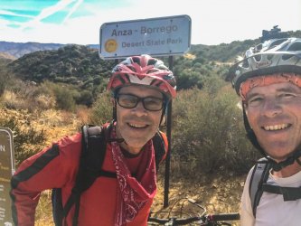
After shuttling our cars to each endpoint, we got started in Anza. It was late November so the desert heat was not going to be a factor.
All smiles in anticipation of a fun downhill to Borrego.
Crisp autumn skies.
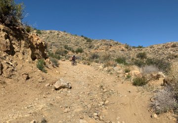
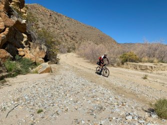
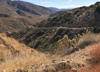
Since the jeep road did not connect anywhere, it was mostly abandoned and in bad shape, but decent enough for a fun downhill bike ride.
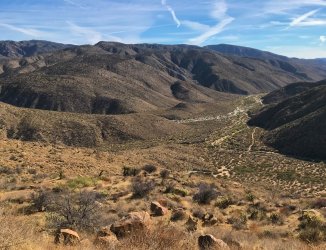
View to the distant canyons ahead.

We dropped over 1500 feet out of Anza very quickly.

Steep fun downhill to the valley floor.

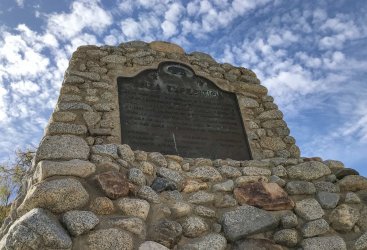
The trail follows the historic Anza route. Anza was the Spanish Colonel who led a band of families north from Mexico, all the way to San Francisco, in an effort to colonize Alta California. At one time it was believed that a child born here, in the desert, to one of the families, during the Anza expedition, may have been the first non native person born in California. Historians later discovered this was probably not really accurate.
This is called the first child monument.

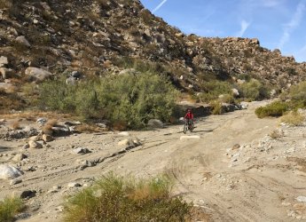
The ride follows the jeep road into a creek bed and becomes quite sandy, but still passable as long as you keep your momentum going.
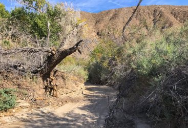
We passed a rock cabin along the way, then weaved our way thru a dry part called the upper willows.

The book describes the mid portion of the ride as being single track that passes thru the Middle Willows area. The jeep trail stops here. Riders must find the path thru the Middle Willows and then follow the spring fed stream for a mile out to the other side of the Willows.
Middle Willows blocking our access.
The line of willows blocking our access was quite tall and impenetrable in most places. We got off our bikes and tried to walk thru any open willow areas that we thought were trails, only to be met with downed willow branches and dead ends. There was no flowing water visible to lead us out to the other side, like the book suggested. We looked along both sides of the canyon walls that created the willow choked passage way; again, no luck. On my map, I noticed that the original Anza trail had gone above and around the entire willow choked valley. We decided to give this a try. We hoisted our bikes up the steep bouldered hills, to look for a passage or trail, only to be met by lots of chollas cactus and loose rocks. We found the old Anza historic trail, but it was unused and not of much help. We worried that traveling so far off trail was going to take out our tires with multiple chollas stickers. Suddenly, we started to feel the daylight was passing us by during the short November day. We assessed our water situation and our clothing situation and the remaining daylight. Chris decided we could search one more half hour for a path thru the Middle Willows before we needed to turn around, and start the unenviable task of biking back 10 miles thru loose sand and then two more miles up the 1500 feet of elevation towards the car. We did not want to risk spending the night on the trail, since the desert evening was going to be cold and dark. Something about our guide book was not adding up. There was not an obvious path forward even on foot. The pictures in the book had shown only shoulder high willows. So we reluctantly decided to turn around and face the fact that we were in an Epic Fail.
Riding back uphill in the deep loose sand was tough, but knowing that we had a steep bike push ahead of us, on top of it, was demoralizing. What was going to be a fun 30 mile ride mostly downhill was now a walking grunt push uphill in an attempt to beat the sun going down behind the mountains in Anza.. Fortunately, we had an extra layer for this contingency and we also had enough water for the extra exertion. We eventually made it back to the car, with some daylight to spare but it was a pretty good workout.
Part Two:
So what had gone wrong? We studied the mountain biking book and learned it was published in 1997. I then went online and found very little digital records of the Anza to Borrego ride. What I did find was a copy of a hand printed outdoor groups adventure schedule. They referenced something called the Coyote Canyon Clunker Classic, which was the exact ride Chris and I were trying to do; Anza to Borrego Springs. Evidently there was an organized ride in the 1980"s thru 2003 that grew to 300 participants and involved shuttle vans and T-shirts and entry fees. For some reason, it stopped being run. A little more research revealed that it was probably a victim of its own success.....it grew too big. That translated to me as being an insurance liability for the sponsors. The ride is very remote and not suitable for someone not equipped with the proper gear or skill level. If anyone breaks down mechanically or physically there is not going to be an ambulance or helicopter coming to the rescue anytime soon. A broken bike would mean a long unenjoyable sand slog for someone that paid $40 dollars for a day of fun. The rides popularity probably started to attract too many folks that were going to be in over their heads once they left Anza. The rides heyday was well before cell phones and to this day there is no cell phone service for most of the ride.
I also spoke with some rangers and they assured me that there was a walking trail thru the middle willows but is was easier to find from the bottom going up and it gets overgrown each year. I became determined to find the way thru the willows so that Chris and I could return and complete the ride. Much of the lower part of the ride from Borrego Springs upstream was familiar to me already. I even have done a trip report on portions of it:
https://backcountrypost.com/threads/bikepacking-anza-borrego.8502/
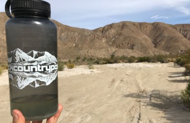
I needed a reason to go back out to the isolation of the desert during the pandemic restrictions if nothing more than to see the cool sunsets.

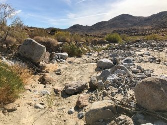
So in December I made my familiar trip to Borrego Springs, biked over boulder alley and then up Coyote canyon to the Middle Willows, for my first time, from the bottom. The approach from the bottom is along some dirt jeep trails except for the last mile or so. Then the trail enters the Coyote Canyon creek bed and gets pretty unfriendly for a mountain bike. For this maintenance trip I put the bike down and went on foot to find the water.

I was by myself this time and felt very isolated when I found I was in a Cougar dining area.
Cougar killed Bighorn ram at the base of the Willows creek.

The area was a perfect spot for mountain lions to ambush prey, as they drank from the perennial spring runoff before it disappeared into the sand. There was another sheep carcass backbone right nearby, so I knew this kill was no accident.
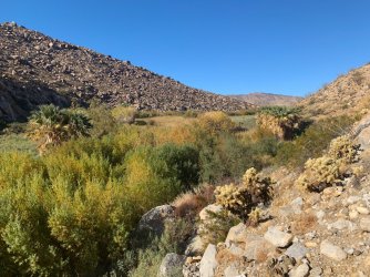
View of the Middle Willows one mile long trail problem from the Borrego side.

I found the flowing water, even in a dry December, and then I found what looked like a spider webbed path thru a tunnel of reeds and willow trees.
I am not claustrophobic but I felt I had to put on a crazy face before entering into the one mile tunnel, miles from anyone or cell service.
I was able to work my way in with snippers for about a quarter of mile up stream which was about 18 inches wide. I was determined to remove any eye level sticks and head level limbs. Eventually, I decided I needed to come back with a better pruning saw to complete my trail maintenance. So I exited and planned another trip. I spoke with the rangers again and they told me that the trail used to be maintained by the horse clubs that used to ride thru. Now that the plants had grown so high, it was no longer anything the horses ( or riders) wanted to enter, so it was not being regularly maintained. With the rangers approval, I decided to return with my hand saw with a goal of making the trail, bike rideable in at least the downstream direction for someone my height.
Cool Barrel cactus growing right out of a small crack in a boulder

Misleading trail arrow to nowhere.
After another maintenance trip I was able to break thru to the other side and find that Chis and I were originally on the right path all along. We had just needed to persevere thru some of the worst of the seasonal fallen willows until we would have reached the spring water, than another .75 of a mile thru the water downstream to daylight.
Part Three:
Now that I knew the path and I knew it was almost rideable thru the water, I recruited some friends to finally complete the ride. We could not get together until April but that turned out be good, because it would coincide with the desert flower bloom and longer riding days. Chris was still unavailable, but Mark was in town. Mark is not very experienced with desert mountain biking but he is a multiple Hawaii Ironman triathlete. We decided to use one car parked at Anza and bike downhill to Borrego, spend the night there, and then return the next day, in the uphill direction, to the car. This sounded physically ambitious to me, since I had made a vow to myself to never have to push my bike back uphill to Anza again, just a few months ago, during Chris and my epic fail. However, once my other friend Scott, joined in, Mark and my plan seemed like a glam camping version of the Clunker Classic compared to Scotts plan. Scott is a Mountain biking demon. He was limited on time, so he decided to drive to Borrego and start pedaling from there early in the dark morning, going uphill. He would pedal all the way thru the willows up to the top near Anza and meet us in the later morning to join Mark and I for our first day descent. So Scott was going to do both directions, in one day, on a hard tail bike ....that had only one gear on it....his preference.
Mark on my borrowed hard tail, loading up, parked at Anza
As we start to descend from Anza, we cross the Pacific Crest Trail right here, then climb back uphill for a bit. We did not see any hikers.

Mark negotiating the speedy descent.

Inside the sandy, narrow, Upper Willows creek bed
Cottonwoods in the desert creek bed.

We changed into different shoes/sandles for the one mile wet part.
The Willows
Trying to ride downstream through an open part of the Middle Willows

It was this deep and had a soft bottom in places, so not really ridable for very long.

Little pour over falls in the middle of the pathway.
Scott and Mark having exited the Middle Willows area.

We had met up with Scott high on the trail, and then made it successfully downhill, together, past the only real obstacle, the willows. By April, the rangers had marked everything with flagging tape making it easier for Scott to navigate upstream in the early light even though it was his first time in the area. We enjoyed the remainder of the day, taking side trips to see flower areas.


We found a tortoise in its den.
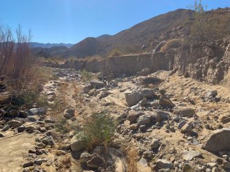
We pedaled down boulder alley, the three water crossings, past the desert garden area and back to civilization.
The last few miles are on asphalt in the vicinity of Borrego Springs. An artist has peppered the desert around town with his metal sculptures.

Scott had an amazing full day, completing both directions in one session. We parted ways with him at the Center Market.

The next day Mark and I started out of town early for session two, to try to beat the heat of the day, as best as we could, heading north to Anza.
Desert Dragon sculpture

Not a banner year for desert flowers but the Ocotillos were blooming strong.
We made it to a lower spring runoff called third crossing before the sun got too high.

We worked a lot harder this day so I made sure to pump some more water at every spring we came to.

This brittle brush bush was in full bloom where we dismounted to change into our wading shoes.
Amazing toad living in the middle of the desert.

Mark fixing his shoe deep in the willow tunnel
Pushing the bikes upstream past the unseen source of the spring water.

Water bottles were getting low as we started to push the bikes uphill to Anza.
At Upper Willows we checked out the inside of Baileys cabin, since it was open.

The push up the hill was tiring but the second time thru offered no surprises. We just had to put our heads down and keep moving.
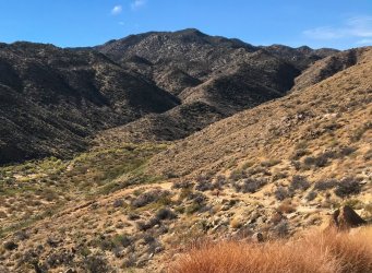
View looking back to Coyote Canyon area from the top switchback
We made it back to the car with plenty of light and still had some energy. It was interesting doing both directions but trudging thru the sand, in the uphill direction, was a lot of work, over the course of the day. Riders with fat tires would probably have made it thru easier. In retrospect, I found out there were a couple of Borrego Spring locals that do the bike ride thru the Middle Willows somewhat regularly. Chris and I evidently had just encountered the trail during a bad time of year. There were a lot of downed willows that made the Anza side willows entry trail unrecognizable and certainly unridable. I also found out there is a multi day, 400 mile ride called the Stagecoach Classic that incorporates all of the Anza -borrego ride into its path but i don't think it was run this year because of covid.
Here is Scotts one day Strava gps track of the ride.
Here is a cool cloud I saw one evening when i was finished doing trail maintenance.
Thanks for watching.
tv
My buddy Chris and I, were looking for a good, full day ride, when Chris found a description in his mountain biking book for a ride that went thru the heart of the Anza Borrego state park. The town of Anza is at 4000 feet and is located in California's Riverside county. An abandoned jeep road descends out of town into Anza Borrego state park and connects to Borrego Springs at sea level, 30+ miles later. This seemed like an ideal ride for us to do, in the desert, in late fall. It would take me thru some upper parts of Coyote Canyon that I had never seen before and it would be downhill, making it easier to pedal thru the sand that we were bound to encounter.
After shuttling our cars to each endpoint, we got started in Anza. It was late November so the desert heat was not going to be a factor.
All smiles in anticipation of a fun downhill to Borrego.
Crisp autumn skies.
Since the jeep road did not connect anywhere, it was mostly abandoned and in bad shape, but decent enough for a fun downhill bike ride.
View to the distant canyons ahead.
We dropped over 1500 feet out of Anza very quickly.
Steep fun downhill to the valley floor.
The trail follows the historic Anza route. Anza was the Spanish Colonel who led a band of families north from Mexico, all the way to San Francisco, in an effort to colonize Alta California. At one time it was believed that a child born here, in the desert, to one of the families, during the Anza expedition, may have been the first non native person born in California. Historians later discovered this was probably not really accurate.
This is called the first child monument.
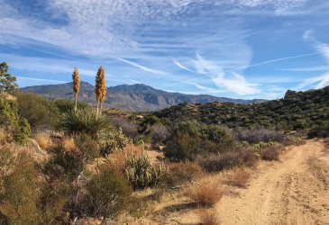
The ride follows the jeep road into a creek bed and becomes quite sandy, but still passable as long as you keep your momentum going.
We passed a rock cabin along the way, then weaved our way thru a dry part called the upper willows.
The book describes the mid portion of the ride as being single track that passes thru the Middle Willows area. The jeep trail stops here. Riders must find the path thru the Middle Willows and then follow the spring fed stream for a mile out to the other side of the Willows.
Middle Willows blocking our access.
The line of willows blocking our access was quite tall and impenetrable in most places. We got off our bikes and tried to walk thru any open willow areas that we thought were trails, only to be met with downed willow branches and dead ends. There was no flowing water visible to lead us out to the other side, like the book suggested. We looked along both sides of the canyon walls that created the willow choked passage way; again, no luck. On my map, I noticed that the original Anza trail had gone above and around the entire willow choked valley. We decided to give this a try. We hoisted our bikes up the steep bouldered hills, to look for a passage or trail, only to be met by lots of chollas cactus and loose rocks. We found the old Anza historic trail, but it was unused and not of much help. We worried that traveling so far off trail was going to take out our tires with multiple chollas stickers. Suddenly, we started to feel the daylight was passing us by during the short November day. We assessed our water situation and our clothing situation and the remaining daylight. Chris decided we could search one more half hour for a path thru the Middle Willows before we needed to turn around, and start the unenviable task of biking back 10 miles thru loose sand and then two more miles up the 1500 feet of elevation towards the car. We did not want to risk spending the night on the trail, since the desert evening was going to be cold and dark. Something about our guide book was not adding up. There was not an obvious path forward even on foot. The pictures in the book had shown only shoulder high willows. So we reluctantly decided to turn around and face the fact that we were in an Epic Fail.
Riding back uphill in the deep loose sand was tough, but knowing that we had a steep bike push ahead of us, on top of it, was demoralizing. What was going to be a fun 30 mile ride mostly downhill was now a walking grunt push uphill in an attempt to beat the sun going down behind the mountains in Anza.. Fortunately, we had an extra layer for this contingency and we also had enough water for the extra exertion. We eventually made it back to the car, with some daylight to spare but it was a pretty good workout.
Part Two:
So what had gone wrong? We studied the mountain biking book and learned it was published in 1997. I then went online and found very little digital records of the Anza to Borrego ride. What I did find was a copy of a hand printed outdoor groups adventure schedule. They referenced something called the Coyote Canyon Clunker Classic, which was the exact ride Chris and I were trying to do; Anza to Borrego Springs. Evidently there was an organized ride in the 1980"s thru 2003 that grew to 300 participants and involved shuttle vans and T-shirts and entry fees. For some reason, it stopped being run. A little more research revealed that it was probably a victim of its own success.....it grew too big. That translated to me as being an insurance liability for the sponsors. The ride is very remote and not suitable for someone not equipped with the proper gear or skill level. If anyone breaks down mechanically or physically there is not going to be an ambulance or helicopter coming to the rescue anytime soon. A broken bike would mean a long unenjoyable sand slog for someone that paid $40 dollars for a day of fun. The rides popularity probably started to attract too many folks that were going to be in over their heads once they left Anza. The rides heyday was well before cell phones and to this day there is no cell phone service for most of the ride.
I also spoke with some rangers and they assured me that there was a walking trail thru the middle willows but is was easier to find from the bottom going up and it gets overgrown each year. I became determined to find the way thru the willows so that Chris and I could return and complete the ride. Much of the lower part of the ride from Borrego Springs upstream was familiar to me already. I even have done a trip report on portions of it:
https://backcountrypost.com/threads/bikepacking-anza-borrego.8502/
I needed a reason to go back out to the isolation of the desert during the pandemic restrictions if nothing more than to see the cool sunsets.
So in December I made my familiar trip to Borrego Springs, biked over boulder alley and then up Coyote canyon to the Middle Willows, for my first time, from the bottom. The approach from the bottom is along some dirt jeep trails except for the last mile or so. Then the trail enters the Coyote Canyon creek bed and gets pretty unfriendly for a mountain bike. For this maintenance trip I put the bike down and went on foot to find the water.
I was by myself this time and felt very isolated when I found I was in a Cougar dining area.
Cougar killed Bighorn ram at the base of the Willows creek.
The area was a perfect spot for mountain lions to ambush prey, as they drank from the perennial spring runoff before it disappeared into the sand. There was another sheep carcass backbone right nearby, so I knew this kill was no accident.
View of the Middle Willows one mile long trail problem from the Borrego side.
I found the flowing water, even in a dry December, and then I found what looked like a spider webbed path thru a tunnel of reeds and willow trees.
I am not claustrophobic but I felt I had to put on a crazy face before entering into the one mile tunnel, miles from anyone or cell service.
I was able to work my way in with snippers for about a quarter of mile up stream which was about 18 inches wide. I was determined to remove any eye level sticks and head level limbs. Eventually, I decided I needed to come back with a better pruning saw to complete my trail maintenance. So I exited and planned another trip. I spoke with the rangers again and they told me that the trail used to be maintained by the horse clubs that used to ride thru. Now that the plants had grown so high, it was no longer anything the horses ( or riders) wanted to enter, so it was not being regularly maintained. With the rangers approval, I decided to return with my hand saw with a goal of making the trail, bike rideable in at least the downstream direction for someone my height.
Cool Barrel cactus growing right out of a small crack in a boulder
Misleading trail arrow to nowhere.
After another maintenance trip I was able to break thru to the other side and find that Chis and I were originally on the right path all along. We had just needed to persevere thru some of the worst of the seasonal fallen willows until we would have reached the spring water, than another .75 of a mile thru the water downstream to daylight.
Part Three:
Now that I knew the path and I knew it was almost rideable thru the water, I recruited some friends to finally complete the ride. We could not get together until April but that turned out be good, because it would coincide with the desert flower bloom and longer riding days. Chris was still unavailable, but Mark was in town. Mark is not very experienced with desert mountain biking but he is a multiple Hawaii Ironman triathlete. We decided to use one car parked at Anza and bike downhill to Borrego, spend the night there, and then return the next day, in the uphill direction, to the car. This sounded physically ambitious to me, since I had made a vow to myself to never have to push my bike back uphill to Anza again, just a few months ago, during Chris and my epic fail. However, once my other friend Scott, joined in, Mark and my plan seemed like a glam camping version of the Clunker Classic compared to Scotts plan. Scott is a Mountain biking demon. He was limited on time, so he decided to drive to Borrego and start pedaling from there early in the dark morning, going uphill. He would pedal all the way thru the willows up to the top near Anza and meet us in the later morning to join Mark and I for our first day descent. So Scott was going to do both directions, in one day, on a hard tail bike ....that had only one gear on it....his preference.
Mark on my borrowed hard tail, loading up, parked at Anza
As we start to descend from Anza, we cross the Pacific Crest Trail right here, then climb back uphill for a bit. We did not see any hikers.
Mark negotiating the speedy descent.
Inside the sandy, narrow, Upper Willows creek bed
Cottonwoods in the desert creek bed.
We changed into different shoes/sandles for the one mile wet part.
The Willows
Trying to ride downstream through an open part of the Middle Willows
It was this deep and had a soft bottom in places, so not really ridable for very long.
Little pour over falls in the middle of the pathway.
Scott and Mark having exited the Middle Willows area.
We had met up with Scott high on the trail, and then made it successfully downhill, together, past the only real obstacle, the willows. By April, the rangers had marked everything with flagging tape making it easier for Scott to navigate upstream in the early light even though it was his first time in the area. We enjoyed the remainder of the day, taking side trips to see flower areas.
We found a tortoise in its den.
We pedaled down boulder alley, the three water crossings, past the desert garden area and back to civilization.
The last few miles are on asphalt in the vicinity of Borrego Springs. An artist has peppered the desert around town with his metal sculptures.
Scott had an amazing full day, completing both directions in one session. We parted ways with him at the Center Market.
The next day Mark and I started out of town early for session two, to try to beat the heat of the day, as best as we could, heading north to Anza.
Desert Dragon sculpture
Not a banner year for desert flowers but the Ocotillos were blooming strong.
We made it to a lower spring runoff called third crossing before the sun got too high.
We worked a lot harder this day so I made sure to pump some more water at every spring we came to.
This brittle brush bush was in full bloom where we dismounted to change into our wading shoes.
Amazing toad living in the middle of the desert.
Mark fixing his shoe deep in the willow tunnel
Pushing the bikes upstream past the unseen source of the spring water.
Water bottles were getting low as we started to push the bikes uphill to Anza.
At Upper Willows we checked out the inside of Baileys cabin, since it was open.
The push up the hill was tiring but the second time thru offered no surprises. We just had to put our heads down and keep moving.
View looking back to Coyote Canyon area from the top switchback
We made it back to the car with plenty of light and still had some energy. It was interesting doing both directions but trudging thru the sand, in the uphill direction, was a lot of work, over the course of the day. Riders with fat tires would probably have made it thru easier. In retrospect, I found out there were a couple of Borrego Spring locals that do the bike ride thru the Middle Willows somewhat regularly. Chris and I evidently had just encountered the trail during a bad time of year. There were a lot of downed willows that made the Anza side willows entry trail unrecognizable and certainly unridable. I also found out there is a multi day, 400 mile ride called the Stagecoach Classic that incorporates all of the Anza -borrego ride into its path but i don't think it was run this year because of covid.
Here is Scotts one day Strava gps track of the ride.
Here is a cool cloud I saw one evening when i was finished doing trail maintenance.
Thanks for watching.
tv
Attachments
-
 IMG_6290.jpg570.2 KB · Views: 9
 -
 IMG_6307.jpg622.9 KB · Views: 8
 -
 IMG_0047.jpg608.3 KB · Views: 7
 -
 IMG_0071.jpg582.7 KB · Views: 7
 -
 IMG_0098.jpg557.6 KB · Views: 7
 -
 IMG_0110.jpg642 KB · Views: 7
 -
 IMG_6259.jpg296.7 KB · Views: 9
 -
 IMG_6271.jpg506.4 KB · Views: 9
 -
 IMG_6278.jpg613.6 KB · Views: 9
 -
 IMG_6280.jpg624.4 KB · Views: 9
 -
 IMG_6284.jpg544.8 KB · Views: 9
 -
 IMG_6295.jpg686.6 KB · Views: 10
 -
 IMG_6300.jpg446.3 KB · Views: 10
 -
 IMG_6304.jpg596.7 KB · Views: 10
 -
 IMG_6313.jpg203.9 KB · Views: 8
Last edited: