Navigation
Install the app
How to install the app on iOS
Follow along with the video below to see how to install our site as a web app on your home screen.
Note: This feature may not be available in some browsers.
More options
Style variation
You are using an out of date browser. It may not display this or other websites correctly.
You should upgrade or use an alternative browser.
You should upgrade or use an alternative browser.
Micro Trip Reports
- Thread starter steve
- Start date
- Status
- Not open for further replies.
mak1277
Member
- Joined
- May 2, 2014
- Messages
- 106
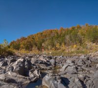
Multi-Purpose family outdoor adventure the weekend of 10/11-10/12 in and around Ohiopyle State Park in Pennsylvania.
Fall colors were maybe not quite at their peak, but still were pretty fantastic.

The day started with a short hike on the Laurel Highlands Hiking Trail, up to an overlook of the Youghiogheny River.

The next order of business was fly fishing...the fish weren't too active, but I at least had time for a photo as I was wading.

And, finally, a trout (my first), caught on a tenkara rod.

Fall colors were maybe not quite at their peak, but still were pretty fantastic.
The day started with a short hike on the Laurel Highlands Hiking Trail, up to an overlook of the Youghiogheny River.
The next order of business was fly fishing...the fish weren't too active, but I at least had time for a photo as I was wading.
And, finally, a trout (my first), caught on a tenkara rod.
Vegan.Hiker
Member
- Joined
- Jul 5, 2014
- Messages
- 2,099
Thanks Mak. Very cool to see some pics of Ohiopyle SP. I wanted to do a night or two out there when I had to fly to Pittsburgh on business this summer but couldn't make it work. Looks beautiful out there.
Kullaberg63
Member
- Joined
- Mar 6, 2014
- Messages
- 683

Last weekend's hike to the river via Rustler and lower Indian Creek.
Curt
Member
- Joined
- Feb 1, 2014
- Messages
- 426
I went backpacking in SE Missouri in October with a father and son on a section of the Ozark Trail. The reason for that location was that it went by a place called Goggins Mountain which is the last name of the father and son. Part of the trail was an equestrian trail and part was a hiking trail. We started and ended at Johnson Shut-Ins State Park. The "shut-ins" is where a portion of the Black River narrows up in something of a canyon with a very rocky bottom. Once we were on the trail we never saw another person. This surprised me because the Ozark Trail is a thru trail of about 350 miles, is only about 100 miles from St. Louis, and goes through the highest area of Missouri. Plus, I would think that fall would be the best time to hike this due to typically good weather, no bugs, and nice fall colors. But the trail looked like it was rarely used though it clearly was being maintained.
The trail typically was heavily forested and the undergrowth was dense. We camped right on the trail because we had trouble finding any place else open enough.


On Goggins Mountain.


The best of the shut-ins.

I was surprised to be able to see the Milky Way.


The trail typically was heavily forested and the undergrowth was dense. We camped right on the trail because we had trouble finding any place else open enough.
On Goggins Mountain.
The best of the shut-ins.
I was surprised to be able to see the Milky Way.
Attachments
- Joined
- Aug 9, 2007
- Messages
- 12,967
I went backpacking in SE Missouri in October with a father and son on a section of the Ozark Trail.
Nice! Great work on the star shots. That is in no way a micro trip report though. That stands very well on it's own. I think from now on anything more than 5 photos and I'm splitting it into it's own thread.
")
Aldaron
Member
- Joined
- Jun 16, 2012
- Messages
- 1,487
I decided to practice some cave photography this weekend. I've been doing a lot of caving since I moved, but taking pictures is time consuming, so it's tough to do when you're exploring with a group of people. Consequently, I don't have any good photos of my cave trips. Today, I just tried to experiment with some camera settings after the group left. I'm thinking about buying an Olympus TG-4 (any experience with that camera?) for these kinds of trips, so I took my mirrorless to replicate some of the limited shutter capabilities of the TG-4 to see if the pictures would still be okay. I think it will do fine...if you throw enough light at it, a four second shutter will catch everything you need, I guess.


- Joined
- Jun 25, 2012
- Messages
- 4,433
x2I like them. Good pictures, thanks for sharing.
Aldaron
Member
- Joined
- Jun 16, 2012
- Messages
- 1,487
I guess I could have told a little bit about the cave...the name of the cave is Hans Kennamer. It's on private land, but it's only about a mile from Cathedral Caverns State Park. It's a maze cave, which is very interesting, because it has a couple of areas that are simply a maze of passages. This is fun for kids because the passages don't really go anywhere, so it's hard for kids to get lost. Also, the maze part of the cave is dry, so kids don't get all wet and muddy. But there are at least three different entrances to the cave, and one of them enters near an underground stream. That part of the cave is very wet but has lots of signs of Indian presence. We had an archaeologist on the trip with us and he showed us places where Indians from several hundred years ago would use cane torches inside the cave and then leave soot marks on the ceiling when they would press the torches against the ceiling to knock off the ashes. The cave had several nice formation areas, including small soda straws. We also saw quite a bit of wildlife in this cave, including bats, salamanders, huge spiders, and a new animal for me: pack rats. The pack rats were huge and looked far more like cute gerbils than gross rats. This is the closest cave to my house (about 25 minutes away) that I've been to so far, and the land owner doesn't mind people going, so I'm glad to have been shown this cave.
So, there, now it's a micro trip report!")
So, there, now it's a micro trip report!


- Joined
- May 19, 2012
- Messages
- 2,017
There is a beautiful 100 year old log cabin not far from my house along the South Fork of Thompson Creek, in the the Thompson Divide area. It is an incredible little building, square cut logs, no chinking, and they are still tight, letting no light through. I had photographed it extensively, and one day before Thanksgiving day I needed those pics. No big deal, checked my backup drive. Not there. Checked my backup backup drive. Not there. I have been using Aperture, but for years I have been saving my RAW files to another separate file outside of Aperture before importing them into Aperture, for the simple reason my Mac does not let me search the Aperture Libraries for specific RAW file. A major flaw. For some reason I had no separate file of these images, and could not find a Aperture Library with them in it. A major lesson for me, get my RAW files out of all my old Aperture Libraries!
And be super diligent with backing up images, onto separate drives.
The bright side was I wanted to go back to get some shots, an adventure this time of year. There was a storm coming, so the only day was Thanksgiving day, because there was a good chance the road would not be passable for the rest of the winter. I had to get there before the sun set behind the high hill behind the building, so I had to leave fairly early. The sketchy part was i had to use my wifes (new to her) Crosstrek, through all kinds of conditions on a skinny road. A descent into the main fork of Thompson Creek, snow packed, and an ascent on the other side with a steep drop off. I was not looking forward to coming back down later! This was challenging for me, as I am not an experienced off road driver. It was a cold day, but in the sun it felt great.
A look down into the main fork of Thompson Creek. My goal is the valley center right, over the ridge coming down from the right:

After my first ascent, and looking over into the North Fork of Thompson Creek. I parked at the bridge right center, and hiked up the road. The road to the cabin breaks off to the left about 2/3's of the way up that little valley, then traverses up to the left over that saddle far center left:


After leaving the main road, looking down on it:


Looking up the road to the cabin. with the road I used into the valley in the back ground:

The view on the other side of the ridge, the cabin is at the far side of the pasture:
The sun was going down quick, but I had plenty of time to get the shots I needed. It was a great little hike.
A couple shots:


And be super diligent with backing up images, onto separate drives.
The bright side was I wanted to go back to get some shots, an adventure this time of year. There was a storm coming, so the only day was Thanksgiving day, because there was a good chance the road would not be passable for the rest of the winter. I had to get there before the sun set behind the high hill behind the building, so I had to leave fairly early. The sketchy part was i had to use my wifes (new to her) Crosstrek, through all kinds of conditions on a skinny road. A descent into the main fork of Thompson Creek, snow packed, and an ascent on the other side with a steep drop off. I was not looking forward to coming back down later! This was challenging for me, as I am not an experienced off road driver. It was a cold day, but in the sun it felt great.
A look down into the main fork of Thompson Creek. My goal is the valley center right, over the ridge coming down from the right:
After my first ascent, and looking over into the North Fork of Thompson Creek. I parked at the bridge right center, and hiked up the road. The road to the cabin breaks off to the left about 2/3's of the way up that little valley, then traverses up to the left over that saddle far center left:
After leaving the main road, looking down on it:
Looking up the road to the cabin. with the road I used into the valley in the back ground:
The view on the other side of the ridge, the cabin is at the far side of the pasture:
The sun was going down quick, but I had plenty of time to get the shots I needed. It was a great little hike.
A couple shots:
Last edited:
- Joined
- Jun 25, 2012
- Messages
- 4,433
Great story, Greg. Thanks!There is a beautiful 100 year old log cabin not far from my house along the South Fork of Thompson Creek, in the the Thompson Divide area. It is an incredible little building, square cut logs, no chinking, and they are still tight, letting no light through. I had photographed it extensively, and one day before Thanksgiving day I needed those pics. No big deal, checked my backup drive. Not there. Checked my backup backup drive. Not there. I have been using Aperture, but for years I have been saving my RAW files to another separate file outside of Aperture before importing them into Aperture, for the simple reason my Mac does not let me search the Aperture Libraries for specific RAW file. A major flaw. For some reason I had no separate file of these images, and could not find a Aperture Library with them in it. A major lesson for me, get my RAW files out of all my old Aperture Libraries!
And be super diligent with backing up images, onto separate drives.
The bright side was I needed to go back to get some shots, an adventure this time of year. There was a storm coming, so the only day was Thanksgiving day, because there was a good chance the road would not be passable for the rest of the winter. I had to get there before the sun set behind the high hill behind the building, so I had to leave fairly early. The sketchy part was i had to use my wifes (new to her) Crosstrek, through all kinds of conditions on a skinny road. A descent into the main fork of Thompson Creek, snow packed, and an ascent on the other side with a steep drop off. I was not looking forward to coming back down later! This was challenging for me, as I am not an experienced off road driver. It was a cold day, but in the sun it felt great.
A look down into the main fork of Thompson Creek. My goal is the valley center right, over the ridge coming down from the right:
After my first ascent, and looking over into the North Fork of Thompson Creek. I parked at the bridge right center, and hiked up the road. The road to the cabin breaks off to the left about 2/3's of the way up that little valley, then traverses up to the left over that saddle far center left:
After leaving the main road, looking down on it:
Looking up the road to the cabin. with the road I used into the valley in the back ground:
The view on the other side of the ridge, the cabin is at the far side of the pasture:
The sun was going down quick, but I had plenty of time to get the shots I needed. It was a great little hike.
A couple shots:
Did you have a specific purpose or job you were needing the cabin shots for?
- Joined
- Jun 25, 2012
- Messages
- 4,433
Plus it really bugs me when I lose stuff like that
I know how that feels. Keeps you up at night and lasts for days.

Curt
Member
- Joined
- Feb 1, 2014
- Messages
- 426
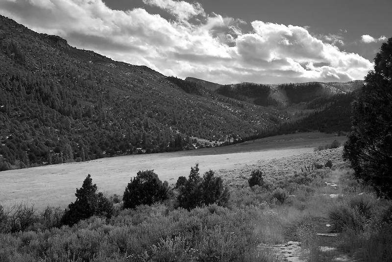
A few photos from the toe of Exit Glacier, in Kenai Fjords NP.
If I was paying attention I'd probably know the answer to this, but when were you back in Alaska?
Isn't this place kinda near Anchorage? How accessible is it? Were you backpacking or on a day hike? Go by yourself?
I hope you keep posting stuff on Alaska. It was never a place I thought I'd like but now, having been there, I'm fascinated. Thanks for the micro report.
Ben
Member
- Joined
- Sep 12, 2014
- Messages
- 1,873
I rode my motorcycle up to Alaska this summer : ) Exit Glacier is a rather short drive from Seward. Seward is not that far from Anchorage, but there are glaciers even closer than this. Views of Exit Glacier are very accessible. There is a trail that goes all the way to the top of it from a NPS visitor center and parking lot. Here's the park link. http://www.nps.gov/kefj/planyourvisit/harding_icefield_trail.htm Here's a report from when i walked to the top of that trail a couple years ago. http://backcountrypost.com/threads/exit-glacier-kenai-fjords-np.4379/ Getting to the toe of the Glacier requires a little off trail route finding, but is a very short walk. I was by my self. I was able to do a trip in Denali, and Gates of the Arctic before i left Alaska. Thanks Curt.
Vegan.Hiker
Member
- Joined
- Jul 5, 2014
- Messages
- 2,099
Starting to shake off the winter rust. Local 13 miler with my buddy Craig past two hiker shelters built by the Civilian Conservation Corps in the 1920's and 1930's. They both were built onto large boulders that served as the back wall, as can be seen in the top picture.


- Joined
- May 31, 2015
- Messages
- 3,353
We headed down to Moab last Friday afternoon and camped at Willow Springs. I was surprised when we got there by 5:30 and most of the spots were filled up. We snagged a small one for ourselves and set up. Everyone around was very friendly, and it was a very quiet night. The next day, we headed to Canyonlands and did a few shorter hikes. Grandview Point, Murphy Point, and False Kiva. We had the first two nearly to ourselves, and the day was beautiful. Fairly windy.
Unfortunately, False Kiva was not a great experience. We started off by taking the wrong trail, as I expected the unmarked trail to be a little hard to follow. This part was enjoyable though because we just followed a pretty little wash as it snaked its way to the edge of the cliff. We looked out and saw we were above where we needed to be, so we backtracked and found the trail. Unfortunately, there was a loud group of 10+ people our age or a few years younger ahead of us, heading up. We tried to wait them out, but they weren't going anywhere anytime soon. So we headed up too. Needless to say, sharing the place with them was unpleasant, especially since they were sitting all over the kiva taking selfies and staring at us like we didn't belong there. I didn't even take pictures. I don't mind sharing places with people, but that was too much.
Overall, the trip was great though. Just wish we would've had better luck timing that False Kiva walk. Looks like we'll have to head back sometime!
- Status
- Not open for further replies.