King's Peak Red Castle Loop Planning

DrNed

The mountains are calling and I must go
Joined
Mar 31, 2013
Messages
1,024
I'm planning a week long Uintas loop this summer starting at China Meadows TH going to Henry's Fork Lake. Spend night's 1-2 at Henry's Fork Lake. Summit King's come down and camp some where near the HIghline / Smith's Fork Pass trail for night 3.

So here's where I need advice. As I see it I've got 3 ways I can access Red Castle area.
1. Continue on the Highline over Tungsten Pass and Porcupine Pass, then leave the trail and go up
and over into the Red Castle area. Doing the reverse of @Nick 's route I measure the distance to be 7.3 miles to an arbitrary camp spot below Red Castle Lake. Going over 3 passes and climbing and descending through the boulders into Red Castle I've got to imagine these would be "hard" miles.

2. Follow Smith's Fork Pass trail over Smith's Fork Pass until this point then leave the trail cutting towards a spot just above Lower Red Castle Lake. Like I have shown here:
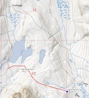
Red Castle Short Cut.jpg
This route I measure to be 6.3 miles to the same camp spot.

3. Follow the trail exactly as it is on the map to the same camp spot comes to about 8.5 miles.

So my question is, is there any reason why I shouldn't take the 2nd route? I've looked at Google Earth and I can't see any geographical reasons why I shouldn't make this short cut. Honestly I can't figure out why the trail doesn't go this way anyways. So for those who have been to the Red Castle area (I haven't) please share your advice on my options and any compelling reasons why I shouldn't take the noted short cut.
 
Your second route looks solid on sat images. Sometimes it can be harder going than you expect, but based on what I can see from space, it looks totally okay. If you want more big vistas and views, the other route is a winner.
 
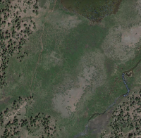
One other thought though. See the thick green on the south end of the lake there? That stuff can be pretty hard to get through. So long as you're loading stuff into your GPS, a line drawn by using sat images to help guide you around the rough stuff might be nice to have. Also to avoid that little cliff band a little east of this shot.

upload_2015-5-31_18-24-3.png
 
If you want more big vistas and views, the other route is a winner.
There's is that to consider too. Thanks for that reminder.

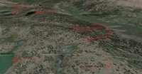
As I've played around with the sat. images I discovered a thing or two.
Shortcut Sat 1.jpg
My text on the image didn't come out as well as it looked on my end, so let me explain. The lake on top left is Lower Red Castle Lake. To the right of that is Langford Lake. Bottom left is East Red Castle Lake. The arrow on the right shows the Smith's Fork Pass trail and the line above that is the supposed course of the Smith's Fork Pass trail, according to the topo map.

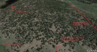
If you move slightly north you get this image:
Shortcut Sat 2.jpg
The important thing here is the trail marked at the bottom middle of the image. Either that is the Smith's Fork Pass trail or unmarked trail. According to the topo map the trail should be on the low side of this ridge, roughly where I have marked. If you continue to follow the trail it comes close to Langford Lake. If the trail I have marked in this image is actually the Smith's Fork Pass trail then my off trail distance and difficulty is almost zero because the trail will take me to the top of the ridge just above Lower Red Castle. All I have to do is drop down and

avoid that little cliff band a little east of this shot.

as well as the other rough stuff and I've cut about 2 miles.

So now I need to decide if I want views or an easy day of hiking. It might be a day of decision.
 
I have found that the trails on the topo maps, at least the USGS/Forest Service ones, are not always right on the money. You can check out some other areas you are familiar with and flip back and forth between the topo layer and the satellite layer and see just how off the trails marked on the topo maps can be, often by dozens of yards or more for many stretches. In fact, a real good example of this is right above Pleasant Grove. Check out the topo map for the GWT trail (#49) between Big Baldy and Battle Creek. The topo map shows the trail as being pretty direct with no switchbacks. However, flip it over to satellite view, or if you're familiar with that trail from doing it yourself, you'll know that in reality, there's at least a good half dozen long switchbacks.

While I've yet to visit the Red Castle area myself, if I were a betting man, I'd bet a good amount of money that what you see in your satellite image is in fact the Smiths Fork Pass Trail. You are pretty much doing what I had in mind myself for King's and Red Castle this summer. I would have done one night up near Henry Fork Lake but closer to Gunsight Pass. Then, if weather was good, hit up Kings and descend down to Yellowstone on day 2. For night #2, I would have camped up around that unnamed lake (or below it down in the trees) northeast of the junction with Smiths Fork Pass Trail. If weather and time were still good, I would have considered moving on up and over the pass and finding a spot near East Red Castle Lake. Then, possibly spend a 3rd night above Red Castle, or at least get a good walk through of it. Here, I was considering the same kind of shortcut but would probably want to keep closer to the rocky edge because as Nick pointed out, much of that green stuff draining into the lakes can be quite marshy. Then it's an easy out back to the trailhead. However, you're probably smart to spend two nights in Henry's if you have the time because you could take a whole day to explore down there while letting your body get a little more used to the altitude. Lots of great little lakes and waterfalls in the upper basin. Just talking about this has me tempted to still go do this route myself as I had planned, even if I have to do it solo. :)
 
I have cut across there before, but stayed a little closer to the mountain. The stream crossing was the only thing I remember that was bad, but I may have been a little further South.

I followed that trail on the satellite your seeing and that appears to be it, as I followed it all the way to the footbridge. Every map I have, including the Forest Service issued map has the trail going low. The last time I hiked it I don't remember the big hill, so that makes sense. It was probably rerouted to get the hiker away from the sheep in the meadow to the East. From what I understand, that is a fairly new thing - the sheep are not to intrude on the wilderness experience. (whatever that means - they are up there, and they are intruding).
 
Like @uintawanderer I have cut across, by lower Red Castle lake there are a lot of social trails for access to the lakeshore, and some campsites even, so you can avoid some of the marshy areas and just find a place across the inlet stream. I also stayed higher when cutting over to East Red Castle, I remember some boggy areas to the sides.

We took the trail down to the foot bridge from East Red Castle, and indeed it does stay up higher as the satellite shows, and at least from Smiths Fork Pass Lake it was well worn by horses, with a little bit more downhill from East to Lower than expected.
 
Thank you all for your input. This is my 17 yo daughter's trip so I'm going to pose the two options to her. We head out in 5 weeks! Thank you again.
 
Of those who have camped around Red Castle, do you have a favorite camp spot? I'm leaning towards the NE side of Lower Red Castle based on what I've seen - it seems to have the best view of Red Castle. Your experiences are appreciated.
 
Of those who have camped around Red Castle, do you have a favorite camp spot? I'm leaning towards the NE side of Lower Red Castle based on what I've seen - it seems to have the best view of Red Castle. Your experiences are appreciated.

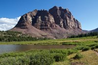
That could be good for a reflection shot. I don't think you can really go wrong though. This was taken along the trail on the SW side.

IMG_7955.jpg
 
Similar threads
Thread starter Title Forum Replies Date
DrNed Henry's Fork - King's Peak Backpacking 17
Brett King's Peak Loop from Henry's Fork TH Trip Planning 10
Nick 2 Boy Scouts Missing Near King's Peak General Discussion 6
Mikjik86 Backpacking Indian Peaks Wilderness - King Lake - August, 2023 Backpacking 0
regehr King's in two days Hiking & Camping 5
Laura V. SEKI Mineral King Loop, June 2021 Backpacking 7
Parma 3 Sons & A King General Discussion 21
balzaccom Clarence King's Life General Discussion 0
stevecochranephotography Storm King Mountain Memorial Trail... Glenwood Springs, Colorado Hiking & Camping 6
balzaccom Five day loop in SEKI out of Mineral King Backpacking 3
Brett King's Castle Loop - 5 day backpacking loop in the Uintas Backpacking 20
IntrepidXJ Crystal & Lead King Basin Off Road 7
BobFink Goschute Mountains, NV , Pisgah Peak, Hawk Watch Migration Site Everything Else 2
TheMountainRabbit Ortenburger Lake, Talus Lake, & Glacier Peak (Grand Teton NP) - October 2023 Backpacking 14
scatman Ensign Peak to Grandview Peak - October 9, 2023 Hiking & Camping 30
scatman Yellowstone's Thorofare, Headwaters of Thorofare Creek, Majo Pass, Younts Peak, Bob's Canyon, and Cub Creek - August 9, 2023 - Days 7 through 10 Backpacking 34
scatman Yellowstone's Thorofare, Headwaters of Thorofare Creek, Majo Pass, Younts Peak, Bob's Canyon, and Cub Creek - August 9, 2023 - Days 1 through 6 Backpacking 56
RockyMntCol Trip Planning Younts Peak / South Fork Yellowstone Trip Planning 12
T Cloud Peak backpack Trip Planning 0
RockyMntCol Cloud Peak Wilderness Loop Trip Planning 1
scatman Reid's Peak - Uintas - July 22, 2023 Hiking & Camping 6
W Paper map for Teton Wilderness (Younts Peak) Gear 4
scatman Grandeur Peak - Dragon Tail Route - June 10, 2023 Hiking & Camping 13
scatman Lookout Peak - May 27, 2023 Hiking & Camping 13
scatman Frary Peak - Antelope Island - February 20, 2023 Hiking & Camping 10
scatman Ensign Peak - November 24, 2022 Hiking & Camping 11
scatman Grandeur Peak - November 11, 2022 Hiking & Camping 15
Titans What’s your unfinished business? Hard canyon access, mtn peak, you name it! General Discussion 54
ram Eldorado Peak 2022 Backpacking 3
TheMountainRabbit Younts Peak (Teton/Washakie Wilderness) - July 2022 Backpacking 22
regehr Lookout Peak 6/25/22 Hiking & Camping 3
scatman Unnamed Peak 8194 - June 25, 2022 Hiking & Camping 17
scatman Mendon Peak - Wellsville Mountain Wilderness - June 4, 2022 Hiking & Camping 13
scatman Dale Peak - May 22, 2022 Hiking & Camping 21
westy Invite Glacier Peak, Washington Meet Up (Members Only) 2
TheMountainRabbit Invite Younts Peak, July 2022 Meet Up (Members Only) 11
LarryBoy SLC: Terrace Hills Drive to Big Mountain Peak Trip Planning 16
ram Glacier Peak July 2021 Backpacking 9
scatman Grandeur Peak - January 15, 2022 Hiking & Camping 6
scatman Frary Peak - Antelope Island - January 7, 2022 Hiking & Camping 21
Wanderlust073 Raleigh Peak Hiking & Camping 4
scatman Grandeur Peak Loop - December 4, 2021 Hiking & Camping 4
scatman Dale Peak - November 27, 2021 Hiking & Camping 3
scatman Grandeur Peak - Dagon's Tail Route - November 21, 2021 Hiking & Camping 9
K Kings Peak Trip Trip Planning 6
TrektheWorld Crater Lake and Lone Eagle Peak Backpacking 1
la_alpinista Thoughts on potential off trail routes in Cloud Peak Wilderness CPW Trip Planning 1
scatman Lone Peak - July 14, 2021 Hiking & Camping 28
Bob Yellowstone - Electric Peak visit Backpacking 2
scatman Lewiston Peak - May 15, 2021 Hiking & Camping 7

Similar threads

Back
Top