shredhiker
Member
- Joined
- Feb 14, 2023
- Messages
- 200
This was initially supposed to be a trip to the high country in Yosemite, which I feel has been fighting me for a few years now. The one trip I made there successfully was in September of 2020, starting from Sunrise Lakes, and for 5 of the 6 days the wildfire smoke was heavy and the views extremely limited. The day I visited Merced Lake in particular, the haze was so thick I couldn’t see 20 feet across the water. May of ’21 I came back, attempting to at least make it to back to Merced from the valley, but my buddy & I came up a few miles short, and had big plans to summit a snow covered Clouds Rest the following day, determined to make it back down to Curry Village in time for dinner (that was some of the best pizza & beer I’ve ever tasted). Then April of ’22, I took my younger brother on his first backpacking trip ever, and we were determined to make it up to Merced Lake from the valley floor. The incoming winter storm warning didn’t deter us from making an attempt to get up there, but around mile 12 of the 13.5 we needed to cover, daylight started running out. Then around 6am the next morning, the snow started coming down as predicted, so we made our way back down to the valley.
For the summer of 2022, I hit the permit lottery jackpot, starting from Sunrise Lakes during the 2nd week of July. I spent a lot of time mapping out the perfect 50 mile route that would include Sunrise Lakes, Cathedral Lakes, Vogelsang, and finally I was going to make it back to Merced Lake in better conditions. I spent a ridiculous amount of time looking through photos of all the areas I wanted to see, staring at the map trying to decide where I should aim to take the best sunrise & sunset photos, and I certainly made sure I had my CA 10 day fishing license. Then just before my trip, the Washburn fire was reported. The southern parts of the park were evacuated, and the northern areas were socked in with smoke. It wasn’t the first trip I’ve had screwed up by wildfires, and I’m sure it won’t be the last, but I have to admit this one was particularly disheartening. There are few places on earth that could excite me more than the backcountry of Yosemite, but it was time to figure out a plan B...
I already had my flight booked to Fresno and rental car reserved. I spent a few hours weighing out whether it was feasible to change my flight and find another rental car; maybe I could make something work heading to Denver, Salt Lake City, Idaho Falls, or Bozeman? Nope, my scheduled flight to Fresno was by far the most sensible choice. I started looking into other wilderness areas I was familiar with, at least on paper. You can’t backpack much of anywhere in CA without a permit it seems, so driving to a random trailhead and winging it for a week like I’d done in other regions was out of the question. I stayed up until 3am digging through my options on recreation.gov, looking at open spots, and figuring out drive times to various trailheads. By pure dumb luck there was one permit available from Onion Valley, I could use that to hike the heavily traveled Rae Lakes Loop! It was well known for being a crowded part of the Sierra, with multiple entry points & permit quotas that were filled every day of the summer, but it was a well documented route that was easy to research in a hurry.
I would have to start my hike the day I flew in from the east coast, making the 6 hour drive to the trailhead, which was just over 9000 ft, then trying to make it in and find a campsite near some usable water source before dark. I didn’t even know about the isobutane fuel shortage at that point. It was just about the most ridiculous start to a trip I could think of, so of course I was set on making it happen.
Day 1
I landed at the Fresno airport, sometime around 11am, thankfully coming from the opposite coast I gain a few hours while traveling. I made the 5 minute walk to the baggage claim, got my rental car, and headed over to the REI at the mall for my usual routine of picking up my camp fuel & grabbing lunch from the In-N-Out Burger across the street. I was shocked to discover they were out of camp fuel? Turns out there was a bit of a shortage going on that I was completely unaware of, so my usual 5 minute grab & go turned into a 2 hour ordeal with me driving all over town, while my girlfriend, who was back home in SC, called around for me until she found a sporting goods store that had a few cans left. I was about to just give up and try cold soaking all of my meals that were meant for boiling water. The entire route was up too high for fires to be allowed, and I was already a few hours late getting out or Fresno. Finally I began the long and beautiful drive to the Onion Valley trailhead, making a quick stop in Lone Pine to grab a sandwich to go, and look at the surrounding landscape wondering how many hikers had summited Mt Whitney that day.
Around 6:30 pm, July 11, I made it to the parking area for my trailhead, and grabbed one of the few open parking spots available. It took about a half hour to get my larger items out of my checked luggage & shoved into my pack, then make sure my extra snack foods were labeled and stored in one of the nearby bear lockers. I rushed through one last dummy check of my pack before finally cinching up the roll top and starting this hike. The terrain was attractive, rocky, and steep. It took about 10 minutes to realize that I was not only in plague like mosquito country, but I also really would have benefited from having a day to acclimate to this altitude. I’d traveled from sea level for trips up in the mountains several times before, usually at around 6000-7000 ft, pacing myself for the first few days I always felt fine. That evening, I did the best I could to look around and enjoy the scenery while struggling to make the 1.3 mile 800 ft climb up to Little Pothole Lake. I found a flat spot to throw my tent up, and eventually drifted off to sleep around 9pm, in spite of the lingering summer heat.


Day 2
I should have found a tent site with a bit more coverage, as by 6 am the sun was shining into my tent as bright & hot as could be, and my lazy morning of sleeping in came to an abrupt halt. I made some coffee & breakfast, which I took down to the shaded area by the lake to enjoy. I spent about half an hour fishing the small bits of lakeshore that were accessible before packing up camp.
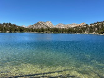
Thirty minutes into the climb up toward Kearsarge pass, I came to Gilbert Lake. It was larger and much more attractive than where I'd stayed the night before. I found myself wishing I'd gone a little further to spend the night there, but a brief stop to enjoy the view would have to suffice. The climb up the pass was dreadful, steep rocky switchbacks, and an elevation that I was totally un-acclimated for, and probably had no business hiking with such haste. I did my best to control my breathing, keep putting one foot in front of the other, and take advantage of the occasional rocks I found to sit on. The scenery did make for some nice motivation as I passed above Flower, Heart, and Big Pothole Lakes. I leap frogged with a few other struggling hikers, and occasionally passed folks on their way down who were entirely too happy to be going the opposite direction.
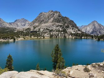
Finally right at 1pm, I made it to the top of the 11,760' Kearsarge Pass. There was a large group of super friendly folks up there, some heading in, others headed out, a few day hikers, and one who was doing the JMT and headed for a resupply. That view looking down into the backcountry was one of the most spectacular I've ever seen. One look into the Kearsarge Lakes Basin & over to Bullfrog Lake, and I knew I was going to cut my day short to camp there. That meant there would be zero chance of me finishing the full loop I had planned, but I was already moving slowly enough to re-evaluate my plans. I've learned that when I come across a place so beautiful it just calls out to me, it's best to stop and spend the night there when I can. The pinnacles made for a unbelievable and dramatic backdrop to the lake, and the water was as blue & pristine as anything I'd ever seen.
I took in the the awesome views as I hiked down to the 2nd lake in the basin, found a spot to call camp, and enjoyed a much needed day of relaxation, fishing, and walking the chain of lakes. Despite seeing several other campers and a few tents around the lakes, when dinner time came I could hardly tell they were close by. This ended up being one of my favorite days I've ever spent on trail anywhere. Tomorrow, I'd figure out what to do for the rest of the trip. It was a short 4.5 mile day, with 2,000' of elevation gain.


Day 3
I had hoped to wake up early enough to fish the lakes a before it started warming up, but the previous few days exhaustion took over, and I didn't roll out of my tent until 9am. The summer heat was beating down on me. While I had breakfast, I looked over the map and decided I would hike over to Bullfrog Lake to enjoy it up close, then start making my way up Glen Pass and camp somewhere in the Rae Lakes Basin.
I have to say Bullfrog Lake lived up to everything I'd ever heard about how pretty it was, not only looking down on it with the brilliant colorful peak that sits southwest of it, but walking the edge of the lake from every vantage point was just a real treat. I dropped my pack next to some nearby trees and spent a good hour just enjoying the scene. Around 12:30 I took my last look around the lake before starting my climb up Glenn Pass.
I felt slightly better than the days prior during my ascent, but still not great. It had taken me a few years to get comfortable hiking up to 10,000' & my first trip up into the 11-12k range was teaching me that it was a whole different animal, worthy of respect. There was a group of hikers I started chatting with over a few sections of switchbacks, and eventually we all ended up having lunch at one of the unnamed lakes & hiding out in the little bit of shade nearby. It turned out they were a guided outfit from REI, all of whom were super friendly, and the 7 of us wound up hiking together the rest of the way up the pass. It was grueling the entire way, but the good company made quick work of our suffering. Just past 5:30, we were all standing up there together at 11,798' for the 2nd day in a row, that was the highest point I'd ever hiked up to.
The view was probably every bit as awesome as Kearsarge Pass had been the day before, but I didn't have all day to celebrate & take it in. After a brief snack break, I headed down into Rae Lakes, hiking solo now as the group I'd met had a schedule to keep to and set out ahead of me. I found myself in the shade as I made my way down, enjoying the beautiful lake scenery. Along the northeastern 'thumb' of Upper Rae Lake, I found myself a nice little tent site, nestled up in the trees with a nice view looking over the water. It was close to 8pm by the time I made camp and I was far too exhausted from the days hike to do anything after dinner, except find a nice log to sit on and enjoy the sunset & the much welcome cool night air. I'd covered around 7 miles and climbed some 1,500'


Day 4
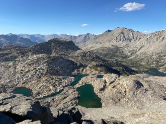
I woke early enough to get a few casts in before the heat was back in full force. After breakfast, I stashed all my food into my bear can, except for the clif bar in my pocket, and spent a few hours just kind of wandering around the gorgeous Rae Lakes Basin. It didn't take long before I bumped into my friends from the day before, and was glad to see everyone in good spirits. I picked the brain of one of the guides for a few minutes who knew the area well about where I should spend the next day or two. There was allegedly an off trail route nearby to Dragon Lake, which he said he always wanted to check out but never had time, then a few miles back toward Glen Pass was the trail into Sixty Lakes Basin which he said was supposed to be great, but he'd never been there either. A few other hikers I'd met in the past days had mentioned Sixty Lakes and two things always came up; how pretty it is, and how no one ever goes there because it isn't part of the popular routes most hikers are on. I decided that's where I would go next.
I really can't get over how beautiful Rae Lakes was, I very well could have spent another night or two there and not feel like I was missing out on whatever else was over the next ridge. I took my time meandering my way back toward camp, ate lunch, packed up, and headed out around 2pm. It's a bit of a climb to get up into Sixty Lakes, but I was rewarded with both of the rumors I'd heard being true. It was speckled with what seemed like countless unnamed lakes surrounded by trees, granite, sand, grassy meadows, just an incredibly diverse array of landscape. I also found the much needed solitude I was seeking. It's worth noting, that everyone I met on trail in the days prior had been pretty awesome. I had a lot of fantastic interactions with practically every hiker I'd met, & was really astonished at the level of camp and trail etiquette all around. It was one of the few trips I can say I actually enjoyed the crowds of people that I typically like to avoid. As pleasant as it was, it was nice to hike into an area alone to enjoy an evening of actually feeling like I was in the wilderness.
One of the guys I had met on trail mentioned that many of the lakes in Sixty Lakes were overrun with bullfrogs, due to a recent plan to restore their habitat, and that if I had any interest in fishing, to find a lake where I couldn't hear them. I have no idea how true that was, even now, but it seemed like logic as sound as any at the time. I kept hiking deeper into the basin that afternoon, trying to find the right lake which I decided had to be one where I saw fish and didn't hear frogs. My curiosity also had me wondering what was just a little further down the trail, which I eventually reached the end of, and kept heading in off trail until I found an area to make camp for the night. I had noticed the last mile or so that everything around me was quite green & lush, and while it was beautiful it screamed buggy. As soon as the sun began to dip, I found myself in the absolute worst mosquito hell I've ever endured. I had long clothing, deet, gloves, and my head net, but still spent the majority of my time hiding out in the tent, wishing I'd settled for one of the perfectly good campsites at one of those rocky lakes I'd passed earlier. I skipped out on a proper dinner that night, opting for some random snack foods instead, and managed to spend about an hour fishing the unnamed lakes nearby, and I also enjoyed one of the most incredible sunsets I've ever witnessed. I hiked somewhere around 5 miles and 700'


Day 5
I woke up around 7 am, ate breakfast inside my tent, and hiked out in a hurry, wearing my full mosquito armor, trying to get out of the grassy meadows and back toward the less buggy trail ASAP. It didn't take long to find myself back down at Rae Lakes, staring up the other side of Glen Pass. The views of Charlotte Lake had caught my eye on the way up on day 3, and I decided that would be my destination for the day. I took what was intended to be a quick break at Upper Rae Lake, and quickly started to feel pretty terrible. I wasn't sure if it was my food disagreeing with me, being up at altitude, or just the amount of energy exerted in the past few days, but whatever it was hit me hard & fast. I rested for about an hour, and it became less intense, but eventually I decided I needed to start making my way up the pass before any storms that may come.
I started the process once again, controlling my breath & slowly putting one foot forward. Surprisingly once I got moving, I felt a little better, then as I made my way up I was even moving faster. By the time I'd gotten to the final push, I felt as strong as I ever have. I was finally over the initial struggle with the altitude and felt like I had my trail legs back. This came about not a moment too soon, as I was chatting with a few other hikers, the skies up on Glenn Pass started to get dark, and it was time to head down. I managed to be up there alone for a few minutes, before I began my descent down toward Charlotte Lake. I never heard thunder or saw rain, and the sun was back on me soon enough. There was an unnamed lake/pool in the rocks not far below the pass that I scrambled down to. Between the hot sun and ice cold water, I decided to take a dip, seeing as I hadn't done so in nearly a week.
I enjoyed the expansive views as I made my way back down the trail, and headed onto Charlotte Lake. It was a popular camping area, I walked about halfway down the lake before finding a tent spot that offered a nice view & some space between myself and the other campers nearby. I set up around 5:30, and headed down to a nice little sandy beach section of the lake where I lounged for a few hours, shockingly I didn't see another hiker pass by on the trail that evening. I wasn't sure if this would be my last night, or if I should try to squeeze in one more. It would be cutting it close to hike out the following morning and drive back to catch my flight, but I was so in love with the area that it was a tempting idea. I covered 9 miles and total of 2,200' of elevation gain.


Day 6
It was very calm and quiet that morning, and there was a mirror like reflection on the lake. I drug my bear can down to the edge of a small grassy meadow, where I had coffee & breakfast overlooking the lake. I looked over the map and decided to hike out that day, feeling that getting back into town the night before my flight was the wiser choice. The idea of a hot shower along with some pizza & a couple of cold beers was also sounding pretty good. I sat there by the lake, so grateful that the trip had turned out as awesome as it did. I had all but forgotten about my plans for Yosemite, the fire, or any of the turmoil that came at the start of this hike. Somehow, it just felt like I was exactly where I was supposed to be.
I was torn between going all the way back down to Bullfrog Lake one last time, or staying on the higher trail that made an easier route to Kearsarge Pass. I decided to stick with the higher trail, as it would offer some different views, and would allow me to make better time. Seeing Bullfrog and Kearsarge Lakes again was just as awesome as the first time I'd looked down on them on day 2. I can absolutely see why the camping restrictions there are in place. I only passed a few other hikers on the trail until I started making my way up Kearsarge Pass, this time feeling pretty great and hiking at a much less embarrassing pace. Actually in that moment, it felt a little ridiculous that it was so hard to come up over that pass the first time. Once again, I was met with a large group of happy hikers at the top. I spent a good hour snacking, laughing, and exchanging stories about where we'd been or where we were going. I took turns taking and having taken some obligatory 'I was here' photos and headed back down to Onion Valley, just past noon.
It wasn't long after that, my phone went off for the first time in the week, signaling that my time in the wild had officially come to an end. I stopped in Lone Pine for the biggest burger and pile of fries & onion rings I could find, then made the long drive back to Fresno.


For the summer of 2022, I hit the permit lottery jackpot, starting from Sunrise Lakes during the 2nd week of July. I spent a lot of time mapping out the perfect 50 mile route that would include Sunrise Lakes, Cathedral Lakes, Vogelsang, and finally I was going to make it back to Merced Lake in better conditions. I spent a ridiculous amount of time looking through photos of all the areas I wanted to see, staring at the map trying to decide where I should aim to take the best sunrise & sunset photos, and I certainly made sure I had my CA 10 day fishing license. Then just before my trip, the Washburn fire was reported. The southern parts of the park were evacuated, and the northern areas were socked in with smoke. It wasn’t the first trip I’ve had screwed up by wildfires, and I’m sure it won’t be the last, but I have to admit this one was particularly disheartening. There are few places on earth that could excite me more than the backcountry of Yosemite, but it was time to figure out a plan B...
I already had my flight booked to Fresno and rental car reserved. I spent a few hours weighing out whether it was feasible to change my flight and find another rental car; maybe I could make something work heading to Denver, Salt Lake City, Idaho Falls, or Bozeman? Nope, my scheduled flight to Fresno was by far the most sensible choice. I started looking into other wilderness areas I was familiar with, at least on paper. You can’t backpack much of anywhere in CA without a permit it seems, so driving to a random trailhead and winging it for a week like I’d done in other regions was out of the question. I stayed up until 3am digging through my options on recreation.gov, looking at open spots, and figuring out drive times to various trailheads. By pure dumb luck there was one permit available from Onion Valley, I could use that to hike the heavily traveled Rae Lakes Loop! It was well known for being a crowded part of the Sierra, with multiple entry points & permit quotas that were filled every day of the summer, but it was a well documented route that was easy to research in a hurry.
I would have to start my hike the day I flew in from the east coast, making the 6 hour drive to the trailhead, which was just over 9000 ft, then trying to make it in and find a campsite near some usable water source before dark. I didn’t even know about the isobutane fuel shortage at that point. It was just about the most ridiculous start to a trip I could think of, so of course I was set on making it happen.
Day 1
I landed at the Fresno airport, sometime around 11am, thankfully coming from the opposite coast I gain a few hours while traveling. I made the 5 minute walk to the baggage claim, got my rental car, and headed over to the REI at the mall for my usual routine of picking up my camp fuel & grabbing lunch from the In-N-Out Burger across the street. I was shocked to discover they were out of camp fuel? Turns out there was a bit of a shortage going on that I was completely unaware of, so my usual 5 minute grab & go turned into a 2 hour ordeal with me driving all over town, while my girlfriend, who was back home in SC, called around for me until she found a sporting goods store that had a few cans left. I was about to just give up and try cold soaking all of my meals that were meant for boiling water. The entire route was up too high for fires to be allowed, and I was already a few hours late getting out or Fresno. Finally I began the long and beautiful drive to the Onion Valley trailhead, making a quick stop in Lone Pine to grab a sandwich to go, and look at the surrounding landscape wondering how many hikers had summited Mt Whitney that day.
Around 6:30 pm, July 11, I made it to the parking area for my trailhead, and grabbed one of the few open parking spots available. It took about a half hour to get my larger items out of my checked luggage & shoved into my pack, then make sure my extra snack foods were labeled and stored in one of the nearby bear lockers. I rushed through one last dummy check of my pack before finally cinching up the roll top and starting this hike. The terrain was attractive, rocky, and steep. It took about 10 minutes to realize that I was not only in plague like mosquito country, but I also really would have benefited from having a day to acclimate to this altitude. I’d traveled from sea level for trips up in the mountains several times before, usually at around 6000-7000 ft, pacing myself for the first few days I always felt fine. That evening, I did the best I could to look around and enjoy the scenery while struggling to make the 1.3 mile 800 ft climb up to Little Pothole Lake. I found a flat spot to throw my tent up, and eventually drifted off to sleep around 9pm, in spite of the lingering summer heat.
Day 2
I should have found a tent site with a bit more coverage, as by 6 am the sun was shining into my tent as bright & hot as could be, and my lazy morning of sleeping in came to an abrupt halt. I made some coffee & breakfast, which I took down to the shaded area by the lake to enjoy. I spent about half an hour fishing the small bits of lakeshore that were accessible before packing up camp.
Thirty minutes into the climb up toward Kearsarge pass, I came to Gilbert Lake. It was larger and much more attractive than where I'd stayed the night before. I found myself wishing I'd gone a little further to spend the night there, but a brief stop to enjoy the view would have to suffice. The climb up the pass was dreadful, steep rocky switchbacks, and an elevation that I was totally un-acclimated for, and probably had no business hiking with such haste. I did my best to control my breathing, keep putting one foot in front of the other, and take advantage of the occasional rocks I found to sit on. The scenery did make for some nice motivation as I passed above Flower, Heart, and Big Pothole Lakes. I leap frogged with a few other struggling hikers, and occasionally passed folks on their way down who were entirely too happy to be going the opposite direction.
Finally right at 1pm, I made it to the top of the 11,760' Kearsarge Pass. There was a large group of super friendly folks up there, some heading in, others headed out, a few day hikers, and one who was doing the JMT and headed for a resupply. That view looking down into the backcountry was one of the most spectacular I've ever seen. One look into the Kearsarge Lakes Basin & over to Bullfrog Lake, and I knew I was going to cut my day short to camp there. That meant there would be zero chance of me finishing the full loop I had planned, but I was already moving slowly enough to re-evaluate my plans. I've learned that when I come across a place so beautiful it just calls out to me, it's best to stop and spend the night there when I can. The pinnacles made for a unbelievable and dramatic backdrop to the lake, and the water was as blue & pristine as anything I'd ever seen.
I took in the the awesome views as I hiked down to the 2nd lake in the basin, found a spot to call camp, and enjoyed a much needed day of relaxation, fishing, and walking the chain of lakes. Despite seeing several other campers and a few tents around the lakes, when dinner time came I could hardly tell they were close by. This ended up being one of my favorite days I've ever spent on trail anywhere. Tomorrow, I'd figure out what to do for the rest of the trip. It was a short 4.5 mile day, with 2,000' of elevation gain.
Day 3
I had hoped to wake up early enough to fish the lakes a before it started warming up, but the previous few days exhaustion took over, and I didn't roll out of my tent until 9am. The summer heat was beating down on me. While I had breakfast, I looked over the map and decided I would hike over to Bullfrog Lake to enjoy it up close, then start making my way up Glen Pass and camp somewhere in the Rae Lakes Basin.
I have to say Bullfrog Lake lived up to everything I'd ever heard about how pretty it was, not only looking down on it with the brilliant colorful peak that sits southwest of it, but walking the edge of the lake from every vantage point was just a real treat. I dropped my pack next to some nearby trees and spent a good hour just enjoying the scene. Around 12:30 I took my last look around the lake before starting my climb up Glenn Pass.
I felt slightly better than the days prior during my ascent, but still not great. It had taken me a few years to get comfortable hiking up to 10,000' & my first trip up into the 11-12k range was teaching me that it was a whole different animal, worthy of respect. There was a group of hikers I started chatting with over a few sections of switchbacks, and eventually we all ended up having lunch at one of the unnamed lakes & hiding out in the little bit of shade nearby. It turned out they were a guided outfit from REI, all of whom were super friendly, and the 7 of us wound up hiking together the rest of the way up the pass. It was grueling the entire way, but the good company made quick work of our suffering. Just past 5:30, we were all standing up there together at 11,798' for the 2nd day in a row, that was the highest point I'd ever hiked up to.
The view was probably every bit as awesome as Kearsarge Pass had been the day before, but I didn't have all day to celebrate & take it in. After a brief snack break, I headed down into Rae Lakes, hiking solo now as the group I'd met had a schedule to keep to and set out ahead of me. I found myself in the shade as I made my way down, enjoying the beautiful lake scenery. Along the northeastern 'thumb' of Upper Rae Lake, I found myself a nice little tent site, nestled up in the trees with a nice view looking over the water. It was close to 8pm by the time I made camp and I was far too exhausted from the days hike to do anything after dinner, except find a nice log to sit on and enjoy the sunset & the much welcome cool night air. I'd covered around 7 miles and climbed some 1,500'
Day 4
I woke early enough to get a few casts in before the heat was back in full force. After breakfast, I stashed all my food into my bear can, except for the clif bar in my pocket, and spent a few hours just kind of wandering around the gorgeous Rae Lakes Basin. It didn't take long before I bumped into my friends from the day before, and was glad to see everyone in good spirits. I picked the brain of one of the guides for a few minutes who knew the area well about where I should spend the next day or two. There was allegedly an off trail route nearby to Dragon Lake, which he said he always wanted to check out but never had time, then a few miles back toward Glen Pass was the trail into Sixty Lakes Basin which he said was supposed to be great, but he'd never been there either. A few other hikers I'd met in the past days had mentioned Sixty Lakes and two things always came up; how pretty it is, and how no one ever goes there because it isn't part of the popular routes most hikers are on. I decided that's where I would go next.
I really can't get over how beautiful Rae Lakes was, I very well could have spent another night or two there and not feel like I was missing out on whatever else was over the next ridge. I took my time meandering my way back toward camp, ate lunch, packed up, and headed out around 2pm. It's a bit of a climb to get up into Sixty Lakes, but I was rewarded with both of the rumors I'd heard being true. It was speckled with what seemed like countless unnamed lakes surrounded by trees, granite, sand, grassy meadows, just an incredibly diverse array of landscape. I also found the much needed solitude I was seeking. It's worth noting, that everyone I met on trail in the days prior had been pretty awesome. I had a lot of fantastic interactions with practically every hiker I'd met, & was really astonished at the level of camp and trail etiquette all around. It was one of the few trips I can say I actually enjoyed the crowds of people that I typically like to avoid. As pleasant as it was, it was nice to hike into an area alone to enjoy an evening of actually feeling like I was in the wilderness.
One of the guys I had met on trail mentioned that many of the lakes in Sixty Lakes were overrun with bullfrogs, due to a recent plan to restore their habitat, and that if I had any interest in fishing, to find a lake where I couldn't hear them. I have no idea how true that was, even now, but it seemed like logic as sound as any at the time. I kept hiking deeper into the basin that afternoon, trying to find the right lake which I decided had to be one where I saw fish and didn't hear frogs. My curiosity also had me wondering what was just a little further down the trail, which I eventually reached the end of, and kept heading in off trail until I found an area to make camp for the night. I had noticed the last mile or so that everything around me was quite green & lush, and while it was beautiful it screamed buggy. As soon as the sun began to dip, I found myself in the absolute worst mosquito hell I've ever endured. I had long clothing, deet, gloves, and my head net, but still spent the majority of my time hiding out in the tent, wishing I'd settled for one of the perfectly good campsites at one of those rocky lakes I'd passed earlier. I skipped out on a proper dinner that night, opting for some random snack foods instead, and managed to spend about an hour fishing the unnamed lakes nearby, and I also enjoyed one of the most incredible sunsets I've ever witnessed. I hiked somewhere around 5 miles and 700'
Day 5
I woke up around 7 am, ate breakfast inside my tent, and hiked out in a hurry, wearing my full mosquito armor, trying to get out of the grassy meadows and back toward the less buggy trail ASAP. It didn't take long to find myself back down at Rae Lakes, staring up the other side of Glen Pass. The views of Charlotte Lake had caught my eye on the way up on day 3, and I decided that would be my destination for the day. I took what was intended to be a quick break at Upper Rae Lake, and quickly started to feel pretty terrible. I wasn't sure if it was my food disagreeing with me, being up at altitude, or just the amount of energy exerted in the past few days, but whatever it was hit me hard & fast. I rested for about an hour, and it became less intense, but eventually I decided I needed to start making my way up the pass before any storms that may come.
I started the process once again, controlling my breath & slowly putting one foot forward. Surprisingly once I got moving, I felt a little better, then as I made my way up I was even moving faster. By the time I'd gotten to the final push, I felt as strong as I ever have. I was finally over the initial struggle with the altitude and felt like I had my trail legs back. This came about not a moment too soon, as I was chatting with a few other hikers, the skies up on Glenn Pass started to get dark, and it was time to head down. I managed to be up there alone for a few minutes, before I began my descent down toward Charlotte Lake. I never heard thunder or saw rain, and the sun was back on me soon enough. There was an unnamed lake/pool in the rocks not far below the pass that I scrambled down to. Between the hot sun and ice cold water, I decided to take a dip, seeing as I hadn't done so in nearly a week.
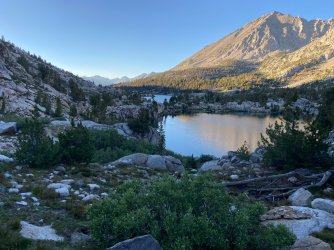
I enjoyed the expansive views as I made my way back down the trail, and headed onto Charlotte Lake. It was a popular camping area, I walked about halfway down the lake before finding a tent spot that offered a nice view & some space between myself and the other campers nearby. I set up around 5:30, and headed down to a nice little sandy beach section of the lake where I lounged for a few hours, shockingly I didn't see another hiker pass by on the trail that evening. I wasn't sure if this would be my last night, or if I should try to squeeze in one more. It would be cutting it close to hike out the following morning and drive back to catch my flight, but I was so in love with the area that it was a tempting idea. I covered 9 miles and total of 2,200' of elevation gain.
Day 6
It was very calm and quiet that morning, and there was a mirror like reflection on the lake. I drug my bear can down to the edge of a small grassy meadow, where I had coffee & breakfast overlooking the lake. I looked over the map and decided to hike out that day, feeling that getting back into town the night before my flight was the wiser choice. The idea of a hot shower along with some pizza & a couple of cold beers was also sounding pretty good. I sat there by the lake, so grateful that the trip had turned out as awesome as it did. I had all but forgotten about my plans for Yosemite, the fire, or any of the turmoil that came at the start of this hike. Somehow, it just felt like I was exactly where I was supposed to be.
I was torn between going all the way back down to Bullfrog Lake one last time, or staying on the higher trail that made an easier route to Kearsarge Pass. I decided to stick with the higher trail, as it would offer some different views, and would allow me to make better time. Seeing Bullfrog and Kearsarge Lakes again was just as awesome as the first time I'd looked down on them on day 2. I can absolutely see why the camping restrictions there are in place. I only passed a few other hikers on the trail until I started making my way up Kearsarge Pass, this time feeling pretty great and hiking at a much less embarrassing pace. Actually in that moment, it felt a little ridiculous that it was so hard to come up over that pass the first time. Once again, I was met with a large group of happy hikers at the top. I spent a good hour snacking, laughing, and exchanging stories about where we'd been or where we were going. I took turns taking and having taken some obligatory 'I was here' photos and headed back down to Onion Valley, just past noon.
It wasn't long after that, my phone went off for the first time in the week, signaling that my time in the wild had officially come to an end. I stopped in Lone Pine for the biggest burger and pile of fries & onion rings I could find, then made the long drive back to Fresno.
Attachments
Last edited:
 )
)")