muir_mountain
Wilderness Seeker
- Joined
- Apr 16, 2016
- Messages
- 121
I just thought I would throw this out there. I have not walked this route, just mapped out where it would, in theory, best go. It is very much a work-in-progress, so I thought I could get input from this fine community. 

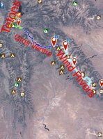
As pictured above, this backpacking route links 3 major mountain ranges in western Wyoming: The Wind River Range, the Gros Ventre Range, and the Teton Range.
Why would this route be appealing? Well, it is modeled (and logistically similar) to the wildly popular JMT(John Muir Trail) in California. The beauty of it is that it takes about 3 weeks to complete, the upper limit of time most folks can take off work.
I'll do a quick summary of the route from South to North. It mostly on trail and roads, with only a few small off-trail sections. Starting from the Big Sandy Trailhead, you more or less follow the Fremont and Highline trails north to the Green River Lakes trailhead, in essence doing a classic Traverse of the range. You can alter this route extensively to visit beautiful off-trail sections if you wish. I recommend taking a look at the Wind River High Route (WRHR) pioneered by Adventure Alan, for a more exciting Traverse than what the trails offer. Once at the Green River Lakes for Resupply, cross the green river bridge and stay north of the river on the Roaring Fork Trail. Follow the curving Green River Valley west and South on trails and 4x4 jeep roads to the Tosi Creek Trailhead.
This is the start of the Gros Ventre section. Follow Tosi Creek into Tosi Basin, then go off-trail east of Double Top Peak and down to Brewster Lake. This is absolutely spectacular country. From Brewster Lake, there is a 4-mile off-trail route described in Douglas Lorain's book "Backpacking Wyoming" that goes north to meet up with trails at the head of Gros Ventre River. Continue north on trails down Crystal Creek then west up the West Fork. Another off-trail section goes north on plateaus to Blue Miner Lake. From there, climb on the north slopes of Sheep Mointain, then off-trail to the northwest to the town of Kelly (all of this is in Wilderness land).
From Kelly, road walk west to Blacktail Butte, climb it, then continue down the north side and make your way to Moose Junction. Road walk past the visitors center (where you can pick up your backcountry permits) to Phelps Lake, where you go up the Death Canyon Trail and follow the Teton Crest Trail to Jenny or String Lake.
WHEW!!
I mapped it out and can provide a GPX track if any of you are interested. Depending on the variations you decide on in the Winds, it is between 210 and 230 miles, the same length as the JMT.
I'd really appreciate it if you guys and gals could help me out with the logistics and alternate ideas for this route (name for it??). I think this could have the potential to be a classic long-distance route, and go toe-to-toe with the JMT, if not exceed it, in scenery and grandeur.
Thank you!!


