House Rock Valley Rd and Vicinity 2016 (Full Report)

powderglut

In search of Fresh
Joined
Oct 17, 2012
Messages
367
UT/AZ Line....I've been in this area a half dozen times over the years. Some of the things we've done: the mandatory Wave hike, a couple of visits to White Pocket, trips to Paw Hole and Cottonwood Cove, Wire Pass, Buckskin, the full Paria hike to Lee's Ferry and partial exploration of the AZ trail. This year I had a pretty good list of things that were nearby, places that needed to be seen. We figured the Stateline CG would be a good base for the 1/2 dozen day hikes I had planned.
First things first. We need to find a camping spot at the BLM, Stateline CG, or... it's on to plan II. 6- 1/2 hours drive from Fruita CO gets us in about 2 PM.
Woohoo!! 4 out of the 8 sites are vacant.IMG_7505.JPG We're in!! This will be home for the next 6 or 7 nights. Virtually just on the other side of the ridge from the Wave. "Set up camp kids!" This ain't no backpack camp. A nice comfy car camp setup. Kinda the way I like it these days, especially if we're staying put and just doing day hikes. 2 couples from Steamboat Spgs and a buddy from Santa Fe NM. God... it's nice to be out of the endless white of the mountains and have predominantly red rocks ruling the view!! And...even better ....back wearing shorts again.
IMG_7502.JPG

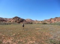
Our first morning and it's a nice cool sunny day. Perfect for hiking up Wahweap Creek for some hoodoos and toad stools.
IMG_7562.JPG
The first look of many...
IMG_7515.JPG

IMG_7518.JPG

IMG_7520.JPG

IMG_7524.JPG

IMG_7528.JPG

IMG_7537.JPG

IMG_7543.JPG

Is this place awesome or what??
IMG_7546.JPG

IMG_7550.JPG

IMG_7553.JPG

IMG_7555.JPG

IMG_7560.JPG

IMG_7563.JPG
What a cool place. Who would ever believe?
I kept thinking this is one wide ass creek. Takes a lot of water to create a fat wash like this. Can't imagine how much water runs thru this place when it's really going. Glad it was a cool day to hike. Exposure to the sun is endless. Good first day. Back to camp. Great dinner, fire and cocktails,wine, stars, company...
IMG_7503.JPG

Next day. So...after doing a hike in Upper Buckskin a few years ago, I noticed an ungodly amount of slick rock that needed exploring. I'd been wanting to see this crazy looking area in my dreams. This was finally the day. West Clark Bench (AKA Edmair's Secret). 5-6 mile drive north of camp and we're off.
IMG_7566.JPG

IMG_7572.JPG

This is going to be good.
IMG_7577.JPG

IMG_7579.JPG

IMG_7582.JPG

IMG_7586.JPG

Lacy rock, brain rock, striped rock. Rock heaven!IMG_7593.JPG

IMG_7597.JPG

IMG_7598.JPG

Nice lunch spot out of the wind
IMG_7606.JPG

I love this place! Huge views and endless rock.

IMG_7613.JPG

IMG_7610.JPG

IMG_7615.JPG

IMG_7627.JPG

IMG_7630.JPG

IMG_7635.JPG

UH OH!!!! I dropped my camera. And...not on the sand. Bummer!! My Canon point and shoot is toast. Wah!! Looks like the rest of this trip will be shot on a smart phone. Good thing we have plenty of beer and rum back at camp. I'm going to need a few good stiff ones.
To be continued.......
 

Attachments

  • IMG_7566.JPG
    IMG_7566.JPG
    115.2 KB · Views: 27
We've had 2 beautiful days so far. Both places completely over met my expectations. It still amazes me that there are so many places to see in this area on both sides of Hwy 89.

My friend tells me he has to get back to Santa Fe for appointments made months ago. Is there something nearby we can checkout for the morning so he can head out after noon. I have the Notch panel in mind just a mile or so south of the campground. I missed it on the last trip down because of a toe injury. The hike in is maybe a mile to the panel. You could then continue over the red ridge to the Sand Cove area of North Coyote Buttes. That is... if you had a permit for that day. We stuck to the panel.
Remember... I ruined my camera so all these pictures are taken with my wife's phone.

20160421_112205.jpg

20160421_112306.jpg

20160421_112356.jpg

20160421_112950.jpg

20160421_112608.jpg


This image makes me think of (don't laugh) a keyboard player in a band. A flamboyant one at that! Definitely my favorite image on the three panels.

20160421_113227.jpg


Time to get my buddy on the road. We take him back to camp and say our goodbyes.
We decide our afternoon needs to be spent a few miles further down HRV rd where the hills are striped with color. Still a bit north of where you would head up towards the Paw Hole.
Just another ordinary place along the road.

20160421_135525.jpg

20160421_135626.jpg

20160421_135903.jpg

20160421_140309.jpg

20160421_143439.jpg

20160421_142527.jpg


20160421_143439.jpg

20160421_143929.jpg

We get back to camp and find a sign. It is the UT/AZ sign made with sticks. After looking on Google earth, I believe he has missed the border by 60 to 70 ft. Nice try though.

20160421_151356.jpg

Our solar showers are nice and hot. Time to get the Arizona dust off us. Another stellar evening of good food and drink. What will tomorrow bring??


I have had Yellow Rock on my list for quite sometime. Approximately 14 miles up Cottonwood rd and you are at the Hackberry Canyon trail. Walk south down the creek a bit, turn right, and start climbing and climbing. Behold an enormous slab of Yellow rock!!

20160422_115124.jpg

20160422_115201.jpg

20160422_115821.jpg

20160422_120033.jpg
20160422_121010.jpg

20160422_121353.jpg

20160422_131611.jpg

Guardian of the cairn
20160422_131922.jpg

20160422_132020.jpg

The Brigham rd across from Yellow Rock.. quite a steep ass rd but the views are worth it.
20160422_144352.jpg

Behind the Cockscomb to the south
20160422_144648.jpg
All in All, the views from the top of Yellow Rock were some of the best in all directions. This place is really visually stunning. I will probably visit this place again. Views from the Brigham rd really give you a perspective of the valley and cockscomb. Yes... another stellar hike with outstanding colors. So much to see around here.

To be continued
 
@Scott Chandler and I did Edmaier's Secret in 2012. That area was INCREDIBLE. I wonder if understanding Geology would ruin the experience. Magic-God-Science. The wonder works using all available perspectives.
 
I decided I'd like to go on vacation with you, hang out in your camp and drink rum. Those colored striped rocks are crazy cool. I never knew something like that even existed. They remind me of Easter eggs.
 
That wall of wafer thin fins is amazing. And although I've been up and down House Rock Valley looking at those coloured Paria movie set-like hills I've never hiked off the road towards them, and your photos of those stripey coloured bumps close up are a really different and cool perspective.
 
I need to take a trip back to the Southern part of the state. Some of those rock formations are just crazy.
 
@chandlerwest ever since I walked passed that place, I have been dreaming of getting back and seeing that jumble of slick rock. More knowledge might actually make viewing it better. Still..It was pretty damn good!!
@Vegan.Hiker dinners weren't too shabby either. We had 1 vegetarian to accommodate. Fajitas, 2 curry dishes, Vietnamese Pho soup, pesto pastas... And yes.. a Rum Mojito hits the spot now and then. Don't see any reason not to have tasty menus and drinks while base camping.
@Ross one of our hiking partners is a water color artist. She said there was zero chance we'd be leaving HRV rd without an up close visit to those striped hills. I'm glad she dragged our asses over there. She was deliriously happy roaming around this area.
 
That wall of wafer thin fins is amazing. And although I've been up and down House Rock Valley looking at those coloured Paria movie set-like hills I've never hiked off the road towards them, and your photos of those stripey coloured bumps close up are a really different and cool perspective.
I was just telling @Jeffrey Chandler that this morning. Yet another excuse for me to drive over there!
 
Before I get started with the rest of the trip. Our pictures of Yellow Rock don't really do it justice. This place really is a gem with huge views everywhere. And the color..... you gotta love the color.
Saturday: My plan is to drive behind the town of Church Wells and see all the hoodoos in the White valley and Sidestep canyon area. Ah......but the wind!!!! The freaking wind!!! Did I say wind? We battened down the hatches at camp and made an attempt to see the rim rock hoodoos across from Paria station. Above Church Wells was going to be way too exposed. Nuh uh!! Huge wind. Next attempt? Toad stools a mile or 2 down the road?? Nuh uh!! Sand in your face, hair, ears.... so on. Brutally big wind! We head for Page to get ice and a few other necessary items. Sand and particulate in the air was off the charts. Oh well....one of those days. On the way back from Page we notice the wind had let up a wee bit so we did get a hike across from the Paria station. Some nice stuff up on the rim. Would be worth giving it more time than we did on a less windy day.
Remember these are all shot with my wife's phone, so some of the images are just so-so.
20160423_151900.jpg

20160423_150653.jpg

20160423_150454.jpg

Sunday: We leave HRV rd and plan on doing a stop in Escalante for the night and then heading for Starr Springs CG by the Henry Mts on Monday. Hikes in Maidenwater, Trachyte, the Irish canyons etc. So much for my perfect plans. By Sunday evening, the weather was starting to go south on us. Snow, rain and wind in the forecast all the way into the weekend. We decide we're staying in Escalante and do hikes locally until the weather runs us out of town.
Monday: Rainy , windy day. I've been to Calf Creek Falls many years ago, but my friends had not. It was time for a revisit on a crappy day. Totally worth seeing again!

20160425_130846.jpg

20160425_130909.jpg

20160425_132709.jpg

Tuesday: This is supposed to be our best day this week. I had planned on seeing Phipps Arch and Maverick Bridge from Spencer Flats, but chose the lower route from rt 12 down the river. I thought we would run into a few people, but was amazed to have this all to ourselves. N'eery a soul! This hike was way better than I thought and Phipps is a very impressive arch.

20160426_141200.jpg

20160426_141452.jpg

20160426_142017.jpg

20160426_153630.jpg

20160426_154547.jpg

Wed: Kind of a gnarly looking day, with snow way up on the high ridges and spitting rain now and then down low. We decide to find the 100 hands pictograph and whatever else is along that ridge above the Escalante River. I do an incredibly superb job of getting us quite lost, as I miss the turn for the big wall and head us high above hwy 12. This was supposed to be the easiest hiking trail of all. What does Reddirtdawg say, "You ain't lost if you don't care" or something like that. We begin backtracking when I run into a bearded guy hiking with his dog. He laughs when I ask if he's hiked this area, and puts us on the right track for 100 hands. Turns out... the house right there on the Escalante river and hwy 12 is his, for better than 35 years. Also turns out, he is one of the original 2 men that started SUWA. He decides to "bag" his intended hike and show us what he considers his proverbial backyard. As we hike up river, we get into many political conversations, and learn quite a lot about the GSENM, BLM, Escalante town locals, along with the origination of SUWA. More petroglyphs and conversation as he takes us further upstream to areas not often seen by others because of his private property lines. We eventually return to his house after coming down a rarely visited side canyon and sit on his redstone patio eating our pack lunches. A rare visit into his home, after getting chased inside because of rain. What a place! It's been an endless 35 year project, adding on to the small cabin and turning it into what it is today. Some framed letters on the wall from Edward Abbey and a few magazine articles give us a bit of historical insight w/BLM and SUWA. It all seems to authenticate his struggle to live in an extremely hostile environment. He was not well received by the locals in the early 80's. Being an environmentalist was like putting a target on your back. I'm thinking now.. that I was meant to get lost that morning, just so we could meet this guy. It was quite enlightening to say the least.

20160427_130406(0).jpg

20160427_131014.jpg

20160427_135725.jpg

20160427_131811.jpg


Thu: Oh man...is it ever snowing. Snowflakes the size of half dollars. So much stuff to pack in the car, and then a snowy ride to Boulder and then over Boulder Mt. This is going to be an interesting day. Snow begins to stick on the road on the way up from Calf Creek. You all know that spot.. The Hogsback! Glad we have all season tires and 4WD, as the plow is coming west and we head east, on the exposed snowy hwy. I think we will stop at Hells Backbone Grill for some breakfast and assess the situation. Funny... but few of the people eating in the restaurant seem to realize how bad it could be going over Boulder Mt. HMMMMM! I think it's serious, and I live it all winter, in Steamboat Spgs CO. We sit out the storm for a little while, enjoying our breakfast, until we spy the plow heading east. That's our cue! Follow the plow up the pass. Thank you plow. I actually felt sorry for the people coming the other way with 6-8 inches of unplowed snow coming down the pass. Crawling is the best description. Even a motorcycle (Idiot). Still snowing in Torrey, but just wet roads. I should have taken pictures of all the waterfalls coming off the walls thru Capitol Reef along hwy 24. We watch the Fremont river swell in size as we get to Hanksville. I can see a northern piece of the Henry Mts shrouded in clouds and packed with new snow. I think we made a good decision staying in Escalante.

20160428_081654.jpg

20160428_081821.jpg


We stopped in Grand Junction to stay with some friend's and had a snowy ride north of I-70 back up to Steamboat. Ahh...spring time in the Rockies, the high desert, .......you know what I mean.

All in all, a very worthy trip despite the wintery weather at the end. Time for a new camera. We still got a lot of places to see!!
 
Last edited:
Nice report. Great pics. What was the date of your trip?
We left on Sunday April 17 and got back to Steamboat Friday the 29th. Not quite the 2 + weeks we planned. Oh well!! I can honestly say, since we've done these spring trips since the late 70's, we have always gotten at least 1 day of snow. Good ole April!!
 
We will follow your tracks in November/December 2018:)
Great trip report - thank you!
Didn't know about the striped hills south of the petroglyph panel. Will try to find them- are they just along the road or how far in?
We have AWD, snow tires and we are used to driving in snow, but whoa.... that Hogsback in the snow is scary- lucky the plow was in front of you!!!
 
Similar threads
Thread starter Title Forum Replies Date
fossana Wire Pass fire (impacting House Rock Rd/Buckskin Gulch) Trip Planning 3
DownPour Mountain House meals and Ziplock bags General Discussion 7
Perry Exploring above Cataract Basin - One of the Best Seats in the House Hiking & Camping 1
Perry Forgive my Non-backcountry Post... Santa Came Early to My House Photography 15
Perry Mountain House Deal Back at CostCo General Discussion 3
kimbur96 Lost Creek Wilderness, Goose Creek to Shaft House. Backpacking 4
Eugene Paria Canyon from White House to Big Spring Backpacking 3
piper01 Moon House Ruins, Cedar Mesa Hiking & Camping 0
John Goering Mountain House at Costco again General Discussion 1
cmgz Paria River- White House to Lee's Ferry Backpacking 4
hatchcanyon Doll House in 1994 Off Road 4
IntrepidXJ Montezuma Canyon and the Doll House Hiking & Camping 11
Nick Mountain House deal on Amazon General Discussion 0
Nick Mountain House meals at Costco General Discussion 4
IntrepidXJ Moon House Ruins & Upper Johns Canyon Hiking & Camping 8
IntrepidXJ The Doll House & Tibbett Arch Hiking & Camping 0
FourisTheNewOne Buckskin Gulch via Wire Pass/White House - 2007 Backpacking 3
TrailScot Hole-in-the-Rock Road - Escalante General Discussion 11
TrailScot Capitol Reef NP - 5 Day Backpacking Adventure from Chimney Rock to Burro Wash - October 2023 Backpacking 10
Jackson Little Rock Creek Backpacking 5
2eez4life Suggestions: Uintas Backpacking with some rock climbing routes Trip Planning 0
kwc Another Southern Adirondacks hike - Clockmill Pond and Rock Lake Hiking & Camping 0
R Pony Express Trail, Black Rock to Simpson Springs Hiking & Camping 3
XID_AZ Willow Gulch from Hole in the Rock Trip Planning 4
fossana Yellow Rock, Pollock Arch, Hackberry Canyon loop (GSENM) Hiking & Camping 10
F Who has been here? Ruin off Hole-in-the-Rock road General Discussion 4
napatony13 UNUSUAL ROCK ART STYLES Off Road 4
scatman Beartooth Wilderness - Flat Rock Lake Lollipop Loop - July 26, 2021 Backpacking 56
C Coyote Gulch via Chimney rock trail Trip Planning 0
napatony13 BISHOP BACKROADS ROCK ART Off Road 2
napatony13 SUCCESSFUL SLEUTHING-Nevada Rock Art Off Road 6
Henk Moab rock art vandalized General Discussion 1
J Bunch O' N. San Rafael Swell summit scrambles April 10-12, 2021 (now w/rock art) Hiking & Camping 3
J Dayhiking Moab's awesome geography, couple hikes to summits and rock art April 8-9, 2021 Hiking & Camping 0
scatman Castle Rock - April 3, 2021 Hiking & Camping 13
norwegianxplorer Preikestolen, Pulpit Rock, Hiking Norways most Iconic and spectacular Landmark & views, Lysefjord, Norway Hiking & Camping 1
Stephanie B Fishing (for Trout) and Hunting (for Rock Art) In and Near Capitol Reef National Park Hiking & Camping 7
T Status of Traffic - Hole in the rock road - Escalante - September? Trip Planning 2
Stephanie B Searchin' for Ruins and Rock Art in San Juan County, UT Hiking & Camping 6
NorthwestWanderer Backpacking the Pasayten Wilderness : Harts Pass, PCT, Windy Pass, Buffalo Pass, Foggy Pass, Jim Pass, Hulman Pass & Rock Pass Meadows Backpacking 3
NorthwestWanderer Waterfall Hikes & the death of my legendary Chevy Cobalt...in a rock slide. Hiking & Camping 8
Stephanie B Eagle Rock Shelter (Delta County, CO) Hiking & Camping 2
Rockskipper Hiker seriously injured by rock at Fisher Towers General Discussion 12
Stephanie B Sand Island and Sand Dune Rock Art Hiking & Camping 1
b.stark Crack In Rock - Fall 2016 Backpacking 6
J Red Rock(s) Canyon Natl.Conservation Area Hikes and Scrambles Nov. 15 and 16, 2017 Hiking & Camping 0
L Red Castle Lakes / Wilson Peak OR Rock Creek Basin Trip Planning 4
LoneWolfOutdoors Eagle Rock Loop Trail in Arkansas Backpacking 6
BJett Shining Rock Wilderness Backpacking 10
Strawsome What is your favorite hike in the Escalante/Hole in the rock road area? General Discussion 6

Similar threads

Back
Top