Vegan.Hiker
Member
- Joined
- Jul 5, 2014
- Messages
- 2,099
Last week I took a week long road trip up to Nova Scotia, Canada. The main purpose of my trip was a 4 day backpacking trip on Cape Chignecto, Nova Scotia. This is just a short report of some of the other stuff I checked along the drive up. I'll do a more in-depth report of my actual backpacking trip in another report.
On the morning of Wednesday June 27th I left my home in New Jersey for Nova Scotia. It would be a 14 hour drive not counting any stops. I didn't know how long into the night I'd be able to last and how far north I'd make it my first day. I ended up making it through NY, CT, MA, NH, up the coast of Maine, through customs and into New Brunswick, Canada that first day. I wanted to stop at either Fundy Provincial Park or Hopewell Rocks Provincial Park along the way. I decided on Hopewell Rocks Provincial Park since it's a much smaller park and I only wanted to stop for a few hours. Since Fundy Provincial Park has a backpacking loop I'd like to do another time, I decided I'd save that park for another trip.
Hopewell Rocks Provincial Park is located in New Brunswick, Canada along the Bay of Fundy. The Bay of Fundy has the largest tides in the world. Whereas the average tidal range (vertical rise and fall) is 2 feet, the Bay of Fundy rises and falls 53 feet (the height of a 5 story building). That equates to over 160 billion tons of water flowing in and out of the bay every 6 hours. That exceeds the amount of water that flows through all of the world's freshwater rivers and streams in the same time period. As you would imagine, that much water movement creates some interesting coastal erosion over time. Since Hopewell Rocks is located in a narrow and shallower strait in the Bay of Fundy, the massive amount of water displacement churns up so much silt that the water is brown in color. Between the erosion and the brown silty water, you could say that the Bay of Fundy is the oceanic version of the Colorado River.
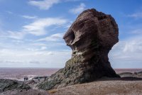
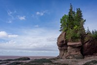
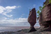
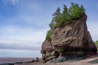
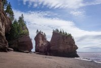
The park has a small trail system, but the real highlight is walking along the coast to view the formations which the park calls flower pot rocks. I took a short trail down to the beach to check them out. It was low tide when I was there so I was able to walk among the formations and get up close. During high tide, the flower pots become flooded around their base and become tiny islands.
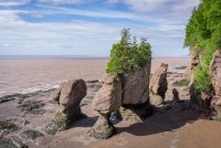
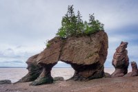
I included this picture below with people walking around to give scale to the size of some of these formations.
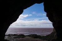
Looking out from one of the many little coves.
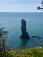
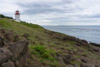
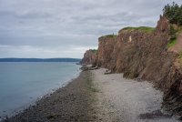
After leaving Hopewell Rocks Provincial Park I continued my drive to Nova Scotia. It would only be about 2.5 more hours to my destination. Once I made it to Nova Scotia, I saw signs for a place called Cape d'Or. I had never heard of it but figured I'd check it out since it was along the way. It turned out to be a few short trails along a cliff on the coast, one of which led to a small little lighthouse on a cape. The cool thing about walking out onto the tip of the cape was that it gave a nice view of the cliffs along the coastline. I noticed that the water on the Nova Scotia were was not brown like it was near Hopewell Rocks in New Brunswick.
My first real glimpse of the rugged Nova Scotia coastline.
And of course I need to include a picture of my trusty travel companion.

After leaving Cape d'Or I headed to the Ranger Station at Cape Chignecto to check-in and pick up my permits for my backpacking trip which I would be starting the next morning. The drive up was pretty cool but the backpacking was amazing. I'm hoping to have time to put together a trip report of the backpacking portion of my trip in the next week or so.
Thanks for checking this out.
John
On the morning of Wednesday June 27th I left my home in New Jersey for Nova Scotia. It would be a 14 hour drive not counting any stops. I didn't know how long into the night I'd be able to last and how far north I'd make it my first day. I ended up making it through NY, CT, MA, NH, up the coast of Maine, through customs and into New Brunswick, Canada that first day. I wanted to stop at either Fundy Provincial Park or Hopewell Rocks Provincial Park along the way. I decided on Hopewell Rocks Provincial Park since it's a much smaller park and I only wanted to stop for a few hours. Since Fundy Provincial Park has a backpacking loop I'd like to do another time, I decided I'd save that park for another trip.
Hopewell Rocks Provincial Park is located in New Brunswick, Canada along the Bay of Fundy. The Bay of Fundy has the largest tides in the world. Whereas the average tidal range (vertical rise and fall) is 2 feet, the Bay of Fundy rises and falls 53 feet (the height of a 5 story building). That equates to over 160 billion tons of water flowing in and out of the bay every 6 hours. That exceeds the amount of water that flows through all of the world's freshwater rivers and streams in the same time period. As you would imagine, that much water movement creates some interesting coastal erosion over time. Since Hopewell Rocks is located in a narrow and shallower strait in the Bay of Fundy, the massive amount of water displacement churns up so much silt that the water is brown in color. Between the erosion and the brown silty water, you could say that the Bay of Fundy is the oceanic version of the Colorado River.
The park has a small trail system, but the real highlight is walking along the coast to view the formations which the park calls flower pot rocks. I took a short trail down to the beach to check them out. It was low tide when I was there so I was able to walk among the formations and get up close. During high tide, the flower pots become flooded around their base and become tiny islands.


I included this picture below with people walking around to give scale to the size of some of these formations.


Looking out from one of the many little coves.


After leaving Hopewell Rocks Provincial Park I continued my drive to Nova Scotia. It would only be about 2.5 more hours to my destination. Once I made it to Nova Scotia, I saw signs for a place called Cape d'Or. I had never heard of it but figured I'd check it out since it was along the way. It turned out to be a few short trails along a cliff on the coast, one of which led to a small little lighthouse on a cape. The cool thing about walking out onto the tip of the cape was that it gave a nice view of the cliffs along the coastline. I noticed that the water on the Nova Scotia were was not brown like it was near Hopewell Rocks in New Brunswick.

My first real glimpse of the rugged Nova Scotia coastline.

And of course I need to include a picture of my trusty travel companion.

After leaving Cape d'Or I headed to the Ranger Station at Cape Chignecto to check-in and pick up my permits for my backpacking trip which I would be starting the next morning. The drive up was pretty cool but the backpacking was amazing. I'm hoping to have time to put together a trip report of the backpacking portion of my trip in the next week or so.
Thanks for checking this out.
John


