Tarp Boy
Member
- Joined
- Jan 18, 2020
- Messages
- 24
June-July 2016
This is a recap of my favorite backpacking trip – one I hope to repeat in the next few years. We were limited to the last week in June and first week in July due to work constraints. We lucked out that year because most of the snow had already melted. Had we gone the next year, we would not have been able to do the loop because of the snow pack.
The trip: We settled on an approximately 50 mile loop connecting the High Sierra Camps in Yosemite NP. What are the HSC? These are improved camps with platform tents, metal cots, running water, dining facilities and other amenities. You can enter a lottery to get a spot to go on guided day hikes and stay at these camps while carrying minimal gear. But that was not our trip.
Each camp also has a backpacker’s area with access to the water and outhouses, but more importantly for us, they have bear boxes where you can store your food. That eliminated the need for us to carry bear canisters, which are otherwise required in the back country.
A trailhead permit is required, and are obtained through a lottery system which you must apply for 168 days in advance. Heads up on this – even though it is called a trailhead permit, it actually means where you will spend your first night! Several trailheads are located at the same place.
Here is a link to more information:
https://www.nps.gov/yose/planyourvisit/backpacking.htm
And a map of the loop:

Here is a more detailed listing of the trails, in counterclockwise order, which matched our general itinerary, except we spent two nights at Merced and day hiked up to Washburn Lake on the extra day:
We arrived two days before due to travel time and the requirement to pick up our permit a day in advance. We were traveling from Cincinnati, OH. We also planned to spend a couple of days in San Francisco after the trip.
Enough of the intro, let’s get on to the trip and photos!
Day 1:
We arrived in San Francisco at about noon and rented a mini-van to transport the 5 of us. We picked up some supplies along the way and had a great meal at the last restaurant before entering the park from the west on Hwy 120. I can’t remember its name but here is a pic in the restaurant ( That's me on your left):

We arrived at the Crane Flat Campground in the late afternoon and then went on an evening hike to see the giant Sequoias at Merced Grove. Recommended!

Day 2:
We headed up Tioga road and stopped at Olmstead Point for a distant view of Half Dome.

Then it was on to the permit station in Tuolumne Meadows and a day hike up to Cathedral Lakes.


Backpacking
Day 3: Glen Aulin
We had decided to cache food in the bear lockers at the May Lake Trailhead. This meant we only needed to carry 2 ½ days of food for the beginning of our hike. The trail to Glen Aulin generally follows the Tuolumne river. At the beginning, as we hiked through the Tuolumne Meadows area, the river is gentle and at times widens out into large tranquil pools.

But as we transitioned from the meadows to the river gorge we experienced the true power of the river. There were many large cascades and waterfalls.


We arrived early enough that we decided to continue with a day-hike further down the Tuolumne.

This was the first day Glen Aulin was open. May Lake would be the next to open two days later. The others would open over the next several weeks.
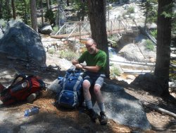
We had a nice spot al to ourselves at the Glen Aulin backpackers camp:

Met the ranger (for the first time). Be sure to have your permit handy, they will ask for it!
Day 4: May Lake
It was a steady, but not too difficult climb from our camp at 7,800 ft to May Lake at 9,270 ft.

Bridge from Glen Aulin.

Typical of the trail signs.


Savoring the adventure!!!

Dusk at May Lake.
Day 5: Sunrise Lake
The morning took us downhill to the trailhead, where we resupplied from our food cache. While at the trailhead, we met the cowpokes loading up supplies for stocking May Lake camp.

We continued downhill, at times walking on blacktop remnants of the original Tioga road I think, and crossed Tioga Road. The climb from there to the pass above Sunrise Lakes was brutal. But we did find a sweet spot along the way, on an unmarked side trail, at an overlook where we enjoyed a leisurely lunch with a view of Half Dome.

And saw this interesting rock formation resembling a dog's head:

That evening was perhaps the height of the mosquito hatch at Sunrise. We had to climb way up from the meadow to try to escape them so we could enjoy our dinner.

High above Sunshine Meadows.
Day 5: Merced
Another beautiful day of hiking - mostly downhill all day.

Twin Granite Domes.


We've reached the Merced river valley and now headed uphill to the camp

Merced Camp - our home for two nights. We chat with the same ranger again. Those folks put in some miles too!

Right behind our camp site. For reference, I'm about 5' 8":

Everything is big out here:

Day 6: Day hike to Washburn Lake
Two of us took the opportunity to take a refreshing dip in the lake!
Day 6: 3000’ climb to Vogelsang
Although this section was rated as strenuous, for the most part it was just a continuous climb - after the first 3.5 miles. Perhaps with the extra day at Merced and several days of hiking we had found our trail legs.


That's Merced lake as seen from the Fletcher Creek trail.


Here's a mule train returning from dropping supplies at Merced:


A view of the tail end of Fletcher Lake as it heads towards Fletcher Creek.
Day 7: Back to Tuolumne and on to the Valley.
The end of a backpack is always a bit bittersweet, but we were ready to finish up. We followed the Rafferty Creek trail back to Tuolumne Valley where we started.

Leaving Vogelsang Camp.

My favorite picture of Rafferty creek looking back towards Vogelsang.
We headed to the valley where we found we could get a free shower at the campground/pool house and then we got what seemed like the best pizza and craft beer we’ve ever had at one of the café’s. Band Aids were extra.

We played tourist with the rest of the throng in the valley before heading to San Francisco the next day. That would be another trip report in and of itself.
But I will share that we visited this "off beat" attraction:

This is a recap of my favorite backpacking trip – one I hope to repeat in the next few years. We were limited to the last week in June and first week in July due to work constraints. We lucked out that year because most of the snow had already melted. Had we gone the next year, we would not have been able to do the loop because of the snow pack.
The trip: We settled on an approximately 50 mile loop connecting the High Sierra Camps in Yosemite NP. What are the HSC? These are improved camps with platform tents, metal cots, running water, dining facilities and other amenities. You can enter a lottery to get a spot to go on guided day hikes and stay at these camps while carrying minimal gear. But that was not our trip.
Each camp also has a backpacker’s area with access to the water and outhouses, but more importantly for us, they have bear boxes where you can store your food. That eliminated the need for us to carry bear canisters, which are otherwise required in the back country.
A trailhead permit is required, and are obtained through a lottery system which you must apply for 168 days in advance. Heads up on this – even though it is called a trailhead permit, it actually means where you will spend your first night! Several trailheads are located at the same place.
Here is a link to more information:
https://www.nps.gov/yose/planyourvisit/backpacking.htm
And a map of the loop:
Here is a more detailed listing of the trails, in counterclockwise order, which matched our general itinerary, except we spent two nights at Merced and day hiked up to Washburn Lake on the extra day:
| From | To | Level | Distance & Time |
| Tuolumne Meadows Lodge | Glen Aulin | Moderate | 8.0 miles, 12.0 km 4 hours |
| Glen Aulin | May Lake | Strenuous | 8.5 miles, 13.7 km 5 hours |
| May Lake | Sunrise | Strenuous | 8.25 miles, 13.0 km 4.5 hours |
| Sunrise | Merced Lake | Moderate | 9.5 miles, 15.5 km 5 hours |
| Merced Lake | Vogelsang | Very Strenuous | 7.8 miles, 12.5 km 6 hours |
| Vogelsang | Tuolumne Meadows Lodge | Moderate | 6.8 miles, 11.0 km 3.5 hours |
We arrived two days before due to travel time and the requirement to pick up our permit a day in advance. We were traveling from Cincinnati, OH. We also planned to spend a couple of days in San Francisco after the trip.
Enough of the intro, let’s get on to the trip and photos!
Day 1:
We arrived in San Francisco at about noon and rented a mini-van to transport the 5 of us. We picked up some supplies along the way and had a great meal at the last restaurant before entering the park from the west on Hwy 120. I can’t remember its name but here is a pic in the restaurant ( That's me on your left):
We arrived at the Crane Flat Campground in the late afternoon and then went on an evening hike to see the giant Sequoias at Merced Grove. Recommended!
Day 2:
We headed up Tioga road and stopped at Olmstead Point for a distant view of Half Dome.
Then it was on to the permit station in Tuolumne Meadows and a day hike up to Cathedral Lakes.
Backpacking
Day 3: Glen Aulin
We had decided to cache food in the bear lockers at the May Lake Trailhead. This meant we only needed to carry 2 ½ days of food for the beginning of our hike. The trail to Glen Aulin generally follows the Tuolumne river. At the beginning, as we hiked through the Tuolumne Meadows area, the river is gentle and at times widens out into large tranquil pools.
But as we transitioned from the meadows to the river gorge we experienced the true power of the river. There were many large cascades and waterfalls.
We arrived early enough that we decided to continue with a day-hike further down the Tuolumne.
This was the first day Glen Aulin was open. May Lake would be the next to open two days later. The others would open over the next several weeks.
We had a nice spot al to ourselves at the Glen Aulin backpackers camp:
Met the ranger (for the first time). Be sure to have your permit handy, they will ask for it!
Day 4: May Lake
It was a steady, but not too difficult climb from our camp at 7,800 ft to May Lake at 9,270 ft.
Bridge from Glen Aulin.
Typical of the trail signs.
Savoring the adventure!!!
Dusk at May Lake.
Day 5: Sunrise Lake
The morning took us downhill to the trailhead, where we resupplied from our food cache. While at the trailhead, we met the cowpokes loading up supplies for stocking May Lake camp.
We continued downhill, at times walking on blacktop remnants of the original Tioga road I think, and crossed Tioga Road. The climb from there to the pass above Sunrise Lakes was brutal. But we did find a sweet spot along the way, on an unmarked side trail, at an overlook where we enjoyed a leisurely lunch with a view of Half Dome.
And saw this interesting rock formation resembling a dog's head:
That evening was perhaps the height of the mosquito hatch at Sunrise. We had to climb way up from the meadow to try to escape them so we could enjoy our dinner.
High above Sunshine Meadows.
Day 5: Merced
Another beautiful day of hiking - mostly downhill all day.
Twin Granite Domes.
We've reached the Merced river valley and now headed uphill to the camp
Merced Camp - our home for two nights. We chat with the same ranger again. Those folks put in some miles too!
Right behind our camp site. For reference, I'm about 5' 8":
Everything is big out here:
Day 6: Day hike to Washburn Lake
Two of us took the opportunity to take a refreshing dip in the lake!
Day 6: 3000’ climb to Vogelsang
Although this section was rated as strenuous, for the most part it was just a continuous climb - after the first 3.5 miles. Perhaps with the extra day at Merced and several days of hiking we had found our trail legs.
That's Merced lake as seen from the Fletcher Creek trail.
Here's a mule train returning from dropping supplies at Merced:
A view of the tail end of Fletcher Lake as it heads towards Fletcher Creek.
Day 7: Back to Tuolumne and on to the Valley.
The end of a backpack is always a bit bittersweet, but we were ready to finish up. We followed the Rafferty Creek trail back to Tuolumne Valley where we started.
Leaving Vogelsang Camp.
My favorite picture of Rafferty creek looking back towards Vogelsang.
We headed to the valley where we found we could get a free shower at the campground/pool house and then we got what seemed like the best pizza and craft beer we’ve ever had at one of the café’s. Band Aids were extra.
We played tourist with the rest of the throng in the valley before heading to San Francisco the next day. That would be another trip report in and of itself.
But I will share that we visited this "off beat" attraction: