DrNed
The mountains are calling and I must go
- Joined
- Mar 31, 2013
- Messages
- 1,026
I was really looking forward to this trip because my daughter Cosette had decided this is what she wanted to do to celebrate graduating high school this year.
Our group would consist of Cosette, two of her siblings, two of her friends, and myself.
We ended up leaving home shortly after 6:00 AM on Monday July 6 to clear skies.
Clear skies continued until Evanston, Wyoming where the clouds became dark, thick and low. It was Mother Nature forewarning us that she can change circumstances as quickly and dramatically as she chooses. Fortunately, after winding through a few small Wyoming towns we again found clear skies and pleasure in how quickly our travel was going.
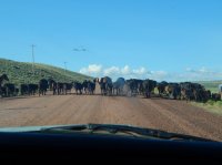
Unfortunately, the quick travel would come to an end as we had to push our way through tons of walking steak.

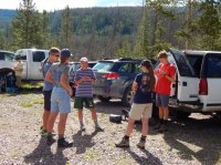
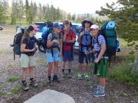
After making our way back into Utah, we eventually found ourselves at the China Meadows Trailhead.

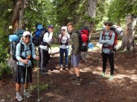
Locked & Loaded.

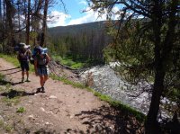
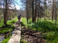
For the first little while the trail runs parallel to the East Fork of Smith's Fork river.

There are also several foot bridges carrying one over particularly wet and sloppy areas.

Being mostly sunny and dry the trail was in good shape as it gently rises towards the south. After about four miles the trail intersects with the Highline Trail, which we took.
After getting on the Highline we start to climb through the pines.
After more than seven miles through the pines the trail takes you up this rather steep meadow.

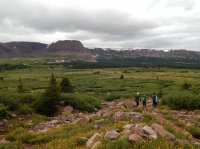
After reaching the top of this meadow we got our first payday. This ended up being my favorite viewpoint of the week. I'm guessing that this is called Henry's Fork Basin, but I don't know.

Teenagers being teenagers.

Going down we were treated to Paintbrush, Columbine and I don't know what the purple ones are called.

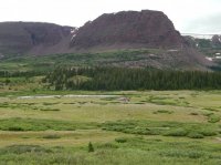
As we head towards Henry's Fork Pass Lake the clouds start to move in.

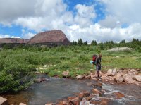
Our final river crossing before reaching camp. Though it's not visible, Henry's Fork Lake is just to the right of this image.

I'm so glad I brought my poles for this trip! Last year I had a fall which inspired to invest in trekking poles. We've debated their usefulness in another thread, but if for no other reason I'm glad I had them for the several river crossings we had similar to the one seen above.
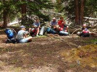
Camp.

Day 1 ended up being 12.25 miles. We were tired and hungry. So we quickly set up camp, ate dinner and talked about our day. During these conversations I realized that, she would never admit it, but my totally fit, soccer player daughter was feeling that she may have bit off more than she could chew - this being only here second BP trip.
By 9:00 the rain started and we all went to our tents for an early bed time.
I was certain a few of the teenagers were having second thoughts when they didn't get out of their tents until 10:00 AM. They had worked hard on Monday so they had earned it.
One of the girls, who is not a daughter of mine wandered off to use the bathroom. My son and I were waiting for her to get back before we took off to explore so we were aware of the time. After she had been gone what felt like long enough we started yelling for her. No response. After a few minutes of that we spread going a hundred yards in each direction, yelling for her.
She was unaccounted for almost :30 nerve racking minutes, but eventually we found her. Miracle #1
Shortly thereafter son and I went out exploring. In our wanderings we came across and few guys on horses with whom we chatted for a few minutes. Come to find out, our missing girl and wandered through their camp on the opposite side of the ridge from where we were camped - more than 1/2 a mile away. Who knows what goes through their minds?
The overcast skies quickly turned to rain and hail. We found a neat couple of pines that looked like they were made for hiding from the weather in. While sitting in this tree I took this shot a little shack.

After the rain slowed down, we got out and wandered around, but I could tell my son had lost his interest in exploring.

So we headed back to camp ate lunch and then the rain really picked up so we ended up spending the afternoon and evening in our tents.
Wednesday morning Cosette decided she wanted to summit Kings, but then hike out on Thursday instead of finishing our loop through Kings and then Red Castle.
So we were on the trail Wednesday by 7:30 AM headed towards Gunsight Pass.


Climbing to the top of Gunsight Pass.

Gunsight Pass.

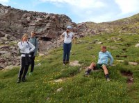
My kids are the ones who need to come up with some kind of awkward pose for every photo.

We took the Gunsight to Anderson short cut which is well traveled and well marked. Here's Roman waiting for the rest of us to catch up.

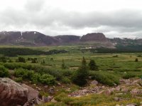
Looking down into Anderson Pass, before beginning our final ascent towards the summit of King's.

As anyone can tell from the previous pictures we've got cloudy, but good skies. The temperature is warm and there is no wind.
My youngest decided she didn't want to climb the rocks so she waited where the trail ends and it's just boulder hopping to the top.
Within what felt like just a few minutes the skies went from cottony clouds to these. At this point it's 11:30 AM and yell to the kids ahead of me that at 12:00 we need to turn back, no matter what.
 In the above photo you can see a point. I thought that was the summit. Nope. I got to that point at 12:00 and thought we need to head down. Not thirty seconds later a clap of thunder boomed. I yelled, "get down now!" They were so far ahead of me there's no way they could have heard me.
My youngest is down below and the wind is picking up and it's starting to rain. More thunder. The rain is turning to hail now. The precipitation is really picking up now so I hide my camera inside my shirt to offer it a little bit of protection. Therefore I don't have any images to back up what I'm about to describe, but please believe me - it's true.
Here's where I admit my mistake - I didn't make everyone bring their rain gear. Shake your heads at me, scold me . . . I know, I KNOW. Rookie.
I finally got down to my daughter. The rain and hail has paused for a few minutes. We get down into some rock to have a little protection.
More thunder. I'm yelling, hoping that kids will hear me. It's raining again, but not hard. We wait :30 more minutes before they all make it down. They say that they could feel static in the rocks and that their hair had been standing on end.
The clouds look like their swirling. I can see lightning glowing inside the clouds with every belch of thunder.
I cut their story off. "Let's go!" I'm inserting this image again to give some context to the next part of my story. It's just below where this picture was taken that I give the kids the "Let's go!" It only takes a minute or two more for the rain to start coming down, hard and it only takes another minute from then for the rain to turn to hail, to snow/hail. At this point we're about 5.5 miles from camp and despite what this image looks like, it's mostly boulder hopping from here to the bump at the bottom of the line coming down from the left in this image.
It's snowing hard now, but as you can see we're above tree line and there is nowhere to hide, so we keep going. The snow/hail begins to accumulate on the ground.
Fortunately the wind and snow are coming from our backs, so we don't have to walk into it.
Kids are getting scared. I tell them it's 1:00 in the afternoon. If it were 7:00 we might have cause to worry. We'll be back to camp before dark. We know exactly where we're going. We'll be okay. Miracle #2
After probably :45 minutes to an hour the storm stops and we're not dead! As soon as it stops the snow on the ground melts. In actuality the accumulation would have been what we would call in winter a dusting, but this is July and it snowed.
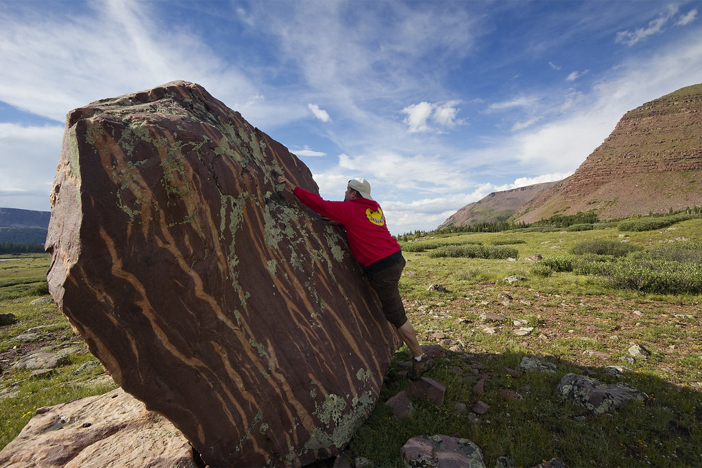
We continue our hike back to camp. As we do so I recognize what I'm pretty sure is the @ashergrey rock.


We saw a porcupine as we passed this formation.

We made it back to camp by 3:45 having done about 11 miles of tough hiking. I get warm and dry clothes on and lay down in my bag. The rain came back keeping me in my tent through the night.
We got up Thursday to a nice breeze which helped dry everything out before breaking camp.
Henry's Fork Pass Lake.

Along the way I was sure to get a picture of this rock for @Parma

Unfortunately, the challenges of this trip were not done. Once we reached the top of the basin I broke the buckle on my hip belt. My son tried to fashion something to help, but it didn't really do much. That means I've got 8 miles of carrying this #@$%&& pack on my shoulders.
With about 4 miles to go the rain started again and that stretch of trail which was so nice on the way in turned to muck. Not to mention all the horses that were really chewing up the mucky areas making it worse for us hikers.
Shortly after 5:00 PM we make it to the truck. We unload our packs, take off our muddy shoes and enjoy our Snickers bars and Cactus Coolers waiting for us. The rain picked up again, encouraging us to get into the truck and get going.
OH NO!! I've got a flat tire. Which was a signal for the rain to come down even harder.
We get out the spare and my son changes it in the pouring rain. Guess what. The spare is mostly flat too.
We're at least 20 miles from a cel signal. What am I going to do? Just keep going. Fortunately, the spare had just enough air that it wasn't riding on the rim. Off we go traveling 10 mph so I don't rip up the flat tire.
After almost an hour I realize I went the wrong way out of the trailhead. Really?! Here's where my "everything's going to be okay" attitude gets really thin and I become angry, frustrated and short tempered.
So eventually I get us back on the right way, but really, I've got a flat tire and there isn't anyplace to take it to get fixed. This is very rural Wyoming. What am I going to do? I have no idea, just keep driving.
It's close to 8:30 PM now and we're almost to the end of the dirt road and oil tanker truck passes us. (Remember, we're going about 10 mph). Once it passes us, it pulls over and the driver hops out.
As we get closer to him my son, sitting behind me says, "No way!" I can clearly see the truck driver now. It's my friend Andy who just started working up here in the oil fields. After exchanging surprises at crossing paths here we explain our tire situation. He's got a air compressor on his truck. He blows up our tire and we're on our way. Miracle #3
We stop in Evanston for a late dinner and check the tire to see that it's holding air (it is) and we finish our drive home without incident. (Yay!)
Featured image for home page:

Our group would consist of Cosette, two of her siblings, two of her friends, and myself.
We ended up leaving home shortly after 6:00 AM on Monday July 6 to clear skies.
Clear skies continued until Evanston, Wyoming where the clouds became dark, thick and low. It was Mother Nature forewarning us that she can change circumstances as quickly and dramatically as she chooses. Fortunately, after winding through a few small Wyoming towns we again found clear skies and pleasure in how quickly our travel was going.
Unfortunately, the quick travel would come to an end as we had to push our way through tons of walking steak.
After making our way back into Utah, we eventually found ourselves at the China Meadows Trailhead.
Locked & Loaded.
For the first little while the trail runs parallel to the East Fork of Smith's Fork river.
There are also several foot bridges carrying one over particularly wet and sloppy areas.
Being mostly sunny and dry the trail was in good shape as it gently rises towards the south. After about four miles the trail intersects with the Highline Trail, which we took.
After getting on the Highline we start to climb through the pines.
After more than seven miles through the pines the trail takes you up this rather steep meadow.
After reaching the top of this meadow we got our first payday. This ended up being my favorite viewpoint of the week. I'm guessing that this is called Henry's Fork Basin, but I don't know.
Teenagers being teenagers.
Going down we were treated to Paintbrush, Columbine and I don't know what the purple ones are called.
As we head towards Henry's Fork Pass Lake the clouds start to move in.
Our final river crossing before reaching camp. Though it's not visible, Henry's Fork Lake is just to the right of this image.
I'm so glad I brought my poles for this trip! Last year I had a fall which inspired to invest in trekking poles. We've debated their usefulness in another thread, but if for no other reason I'm glad I had them for the several river crossings we had similar to the one seen above.
Camp.
Day 1 ended up being 12.25 miles. We were tired and hungry. So we quickly set up camp, ate dinner and talked about our day. During these conversations I realized that, she would never admit it, but my totally fit, soccer player daughter was feeling that she may have bit off more than she could chew - this being only here second BP trip.
By 9:00 the rain started and we all went to our tents for an early bed time.
I was certain a few of the teenagers were having second thoughts when they didn't get out of their tents until 10:00 AM. They had worked hard on Monday so they had earned it.
One of the girls, who is not a daughter of mine wandered off to use the bathroom. My son and I were waiting for her to get back before we took off to explore so we were aware of the time. After she had been gone what felt like long enough we started yelling for her. No response. After a few minutes of that we spread going a hundred yards in each direction, yelling for her.
She was unaccounted for almost :30 nerve racking minutes, but eventually we found her. Miracle #1
Shortly thereafter son and I went out exploring. In our wanderings we came across and few guys on horses with whom we chatted for a few minutes. Come to find out, our missing girl and wandered through their camp on the opposite side of the ridge from where we were camped - more than 1/2 a mile away. Who knows what goes through their minds?
The overcast skies quickly turned to rain and hail. We found a neat couple of pines that looked like they were made for hiding from the weather in. While sitting in this tree I took this shot a little shack.
After the rain slowed down, we got out and wandered around, but I could tell my son had lost his interest in exploring.
So we headed back to camp ate lunch and then the rain really picked up so we ended up spending the afternoon and evening in our tents.
Wednesday morning Cosette decided she wanted to summit Kings, but then hike out on Thursday instead of finishing our loop through Kings and then Red Castle.
So we were on the trail Wednesday by 7:30 AM headed towards Gunsight Pass.
Climbing to the top of Gunsight Pass.
Gunsight Pass.
My kids are the ones who need to come up with some kind of awkward pose for every photo.
We took the Gunsight to Anderson short cut which is well traveled and well marked. Here's Roman waiting for the rest of us to catch up.
Looking down into Anderson Pass, before beginning our final ascent towards the summit of King's.
As anyone can tell from the previous pictures we've got cloudy, but good skies. The temperature is warm and there is no wind.
My youngest decided she didn't want to climb the rocks so she waited where the trail ends and it's just boulder hopping to the top.
Within what felt like just a few minutes the skies went from cottony clouds to these. At this point it's 11:30 AM and yell to the kids ahead of me that at 12:00 we need to turn back, no matter what.
In the above photo you can see a point. I thought that was the summit. Nope. I got to that point at 12:00 and thought we need to head down. Not thirty seconds later a clap of thunder boomed. I yelled, "get down now!" They were so far ahead of me there's no way they could have heard me.My youngest is down below and the wind is picking up and it's starting to rain. More thunder. The rain is turning to hail now. The precipitation is really picking up now so I hide my camera inside my shirt to offer it a little bit of protection. Therefore I don't have any images to back up what I'm about to describe, but please believe me - it's true.
Here's where I admit my mistake - I didn't make everyone bring their rain gear. Shake your heads at me, scold me . . . I know, I KNOW. Rookie.
I finally got down to my daughter. The rain and hail has paused for a few minutes. We get down into some rock to have a little protection.
More thunder. I'm yelling, hoping that kids will hear me. It's raining again, but not hard. We wait :30 more minutes before they all make it down. They say that they could feel static in the rocks and that their hair had been standing on end.
The clouds look like their swirling. I can see lightning glowing inside the clouds with every belch of thunder.
I cut their story off. "Let's go!" I'm inserting this image again to give some context to the next part of my story. It's just below where this picture was taken that I give the kids the "Let's go!" It only takes a minute or two more for the rain to start coming down, hard and it only takes another minute from then for the rain to turn to hail, to snow/hail. At this point we're about 5.5 miles from camp and despite what this image looks like, it's mostly boulder hopping from here to the bump at the bottom of the line coming down from the left in this image.
It's snowing hard now, but as you can see we're above tree line and there is nowhere to hide, so we keep going. The snow/hail begins to accumulate on the ground.
Fortunately the wind and snow are coming from our backs, so we don't have to walk into it.
Kids are getting scared. I tell them it's 1:00 in the afternoon. If it were 7:00 we might have cause to worry. We'll be back to camp before dark. We know exactly where we're going. We'll be okay. Miracle #2
After probably :45 minutes to an hour the storm stops and we're not dead! As soon as it stops the snow on the ground melts. In actuality the accumulation would have been what we would call in winter a dusting, but this is July and it snowed.
We continue our hike back to camp. As we do so I recognize what I'm pretty sure is the @ashergrey rock.
We saw a porcupine as we passed this formation.
We made it back to camp by 3:45 having done about 11 miles of tough hiking. I get warm and dry clothes on and lay down in my bag. The rain came back keeping me in my tent through the night.
We got up Thursday to a nice breeze which helped dry everything out before breaking camp.
Henry's Fork Pass Lake.
Along the way I was sure to get a picture of this rock for @Parma
Unfortunately, the challenges of this trip were not done. Once we reached the top of the basin I broke the buckle on my hip belt. My son tried to fashion something to help, but it didn't really do much. That means I've got 8 miles of carrying this #@$%&& pack on my shoulders.
With about 4 miles to go the rain started again and that stretch of trail which was so nice on the way in turned to muck. Not to mention all the horses that were really chewing up the mucky areas making it worse for us hikers.
Shortly after 5:00 PM we make it to the truck. We unload our packs, take off our muddy shoes and enjoy our Snickers bars and Cactus Coolers waiting for us. The rain picked up again, encouraging us to get into the truck and get going.
OH NO!! I've got a flat tire. Which was a signal for the rain to come down even harder.
We get out the spare and my son changes it in the pouring rain. Guess what. The spare is mostly flat too.
We're at least 20 miles from a cel signal. What am I going to do? Just keep going. Fortunately, the spare had just enough air that it wasn't riding on the rim. Off we go traveling 10 mph so I don't rip up the flat tire.
After almost an hour I realize I went the wrong way out of the trailhead. Really?! Here's where my "everything's going to be okay" attitude gets really thin and I become angry, frustrated and short tempered.
So eventually I get us back on the right way, but really, I've got a flat tire and there isn't anyplace to take it to get fixed. This is very rural Wyoming. What am I going to do? I have no idea, just keep driving.
It's close to 8:30 PM now and we're almost to the end of the dirt road and oil tanker truck passes us. (Remember, we're going about 10 mph). Once it passes us, it pulls over and the driver hops out.
As we get closer to him my son, sitting behind me says, "No way!" I can clearly see the truck driver now. It's my friend Andy who just started working up here in the oil fields. After exchanging surprises at crossing paths here we explain our tire situation. He's got a air compressor on his truck. He blows up our tire and we're on our way. Miracle #3
We stop in Evanston for a late dinner and check the tire to see that it's holding air (it is) and we finish our drive home without incident. (Yay!)
Featured image for home page:
Attachments
-
 DSCN1157.JPG74.4 KB · Views: 31
 -
 DSCN1164.JPG187.1 KB · Views: 31
 -
 DSCN1165.JPG184.7 KB · Views: 31
 -
 DSCN1168.JPG207 KB · Views: 30
 -
 DSCN1173.JPG229.4 KB · Views: 31
 -
 DSCN1184.JPG240.8 KB · Views: 30
 -
 DSCN1249.JPG183.4 KB · Views: 30
 -
 DSCN1278.JPG112.3 KB · Views: 31
 -
 DSCN1279.JPG119.4 KB · Views: 29
 -
 DSCN1281.JPG127.2 KB · Views: 28
 -
 DSCN1285.JPG212.6 KB · Views: 28
 -
 DSCN1292.JPG148.5 KB · Views: 29
 A different kind of ascent