Guess the spot

Cool. In Utah??? Must be part of the backcountry aviators network. Maybe those are all dirt though. I have no idea where but cool nonetheless.
 
Almost likes like Minersville area
 
I know the general area because I know where you went 4 years ago... I have no idea other than somewhere around Mount Trumbull. I'm going to guess Lake Valley.
 
Just over the hill from Toroweap, and the only spot you can drive to the edge of the river -800' drop. The lava flow after the air strip is only 1100 years old. The same lava flow blocked the river at that time. Dropping off the AZ strip into this place was like changing the foliage/climate zone, we saw some cool plants and cactus down in this spot.
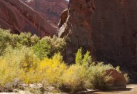
 
Just over the hill from Toroweap, and the only spot you can drive to the edge of the river -800' drop. The lava flow after the air strip is only 1100 years old. The same lava flow blocked the river at that time. Dropping off the AZ strip into this place was like changing the foliage/climate zone, we saw some cool plants and cactus down in this spot.

Im assuming that means I was close enough! What tributary/gulch/branch/fork/etc is this picture of running into the Escalante? (Nick you cant guess for a couple hours as I gave you the answer not too long ago!)
IMG_9981.jpg
 
Hmm...I was down on the Escalante this spring but I this doesn't look familiar. I'll throw out a wild guess: Fool's Canyon?
 
Seldom Seen Anderson, your guess was about 2 or 3 miles away. Close enough, I thought I would post a photo of the runway. If your ever down that way and have a good 4x4, make the drive down the lava field to the end of Whitmore Canyon and look at the river. The vegitation and cactus down in Whitmore are very different then the rest of the AZ Strip, a completely different zone.
 
Back
Top