Navigation
Install the app
How to install the app on iOS
Follow along with the video below to see how to install our site as a web app on your home screen.
Note: This feature may not be available in some browsers.
More options
Style variation
You are using an out of date browser. It may not display this or other websites correctly.
You should upgrade or use an alternative browser.
You should upgrade or use an alternative browser.
Guess the spot: Maps Edition
- Thread starter Backcountry Post
- Start date
HomerJ
Member
- Joined
- Jan 19, 2012
- Messages
- 1,199
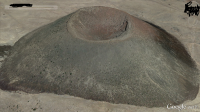
Bob, is that lava flow to the north? That's pretty cool!!!man...too easy....
You been there? It's neat from the top, very distinctive
https://www.google.com/maps/place/3...324353,12648m/data=!3m1!1e3!4m2!3m1!1s0x0:0x0
- Joined
- Jun 25, 2012
- Messages
- 4,430
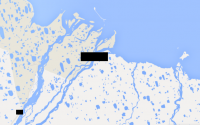
Alaska, I believe you. Those "pots" of water all along the tundra. Forget what they call them. Post the satellite view and I'll bet we can get it. 
Here is my WAG. ANWAR. And the black spots are where the oil will be spilling out if they drill it and the first earthquake happens.
Here is my WAG. ANWAR. And the black spots are where the oil will be spilling out if they drill it and the first earthquake happens.
John Goering
Member
- Joined
- Sep 30, 2014
- Messages
- 502
Purdhoe Bay
Ben
Member
- Joined
- Sep 12, 2014
- Messages
- 1,873
you got it @John Goering . that's the end of the dalton highway at deadhorse, ak. the road was the rare feature. and the town.
- Joined
- Jun 25, 2012
- Messages
- 4,430
You going there this summer?you got it @John Goering . that's the end of the dalton highway at deadhorse, ak. the road was the rare feature. and the town.
John Goering
Member
- Joined
- Sep 30, 2014
- Messages
- 502
Been busy the last week but will spread the redactilite on something soon-----
Wyatt Carson
Desert Vagabond
- Joined
- Apr 15, 2015
- Messages
- 331
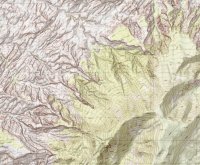
Is that over by Navajo mountain NW?
Don't like ads? Become a BCP Supporting Member and kiss them all goodbye. Click here for more info.


