swmalone
Member
- Joined
- Apr 27, 2016
- Messages
- 484
My wife and I attempted to visit the GSENM area in March of 2019 and were pretty much skunked with the amount of precipitation that they were receiving. That muddy trip can be found here: GSENM March 2019
March 8
This year we headed down in March again, but what a difference a couple of years can make. He headed down on March 8th at a chipper 5 a.m. We arrived at the Interagency Visitor Center at around 11 a.m. I knew that they weren't open but we picked up a camping permit and I had really hoped that at least the restrooms would be open since they were exterior to the main building, but no luck.
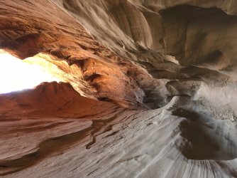
After filling up on gas and taking care of some other business we headed down HITRR. Instead of mud this time we were treated to dust. We drove to the Upper Dry Fork Trailhead and set off on a trip through the Dry Fork Narrows heading towards Peak-a-Boo and Spooky.
We had the Dry Fork Narrows completely to ourselves until right at the end and they approached Peak-a-Boo. There were a great warm up to exploring the area.

We arrived at the start of Peak-a-Boo to a bit of a line. A couple of people decided to turn back after attempting to climb in and a group behind us decided to leave after seeing the couple tap out. After waiting a few minutes it was finally our turn to scramble up into Peak-a-Boo.
Immediately upon entering we were greeted by a series of small bridges. I am sure most of you have probably done these canyons, but it was our first time and after reading about them so many times we were really soaking them in.

We worked our way through Peak-a-Boo trying to leave enough space between the groups in front of us so that everyone could somewhat feel like they had it to themselves. There were no groups immediately behind us, so taking our time wasn't holding anyone up.
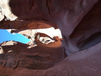
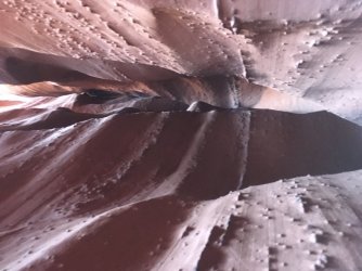
We eventually popped out of Peak-A-Boo and headed across to spooky, talking with the groups that had exited ahead of us. When we arrived at Spooky they let us go first and we began our decent. My wife was comparing Spooky to a haunted house and was giggling the entire way through. We eventually arrived at the chockstone jungle area and there was a couple trying to talk a woman through it. We couldn't even see her and she had apparently went over the top rather than dropping down below, which was what the couple guiding her planned to do as well until I told them it was a lot easier to go under and offered them the use of a small rope I had if they needed it. They let us go first, partly because I'm not sure they trusted me. There was a knotted rope there that made the decent much easier, but if you stay on the left side it is a pretty easy down climb.


We enjoyed the rest of our time in Spooky and upon exiting contemplated heading towards Brimstone but we wanted to find a campsite on Old Sheffield before it got dark. On our way back to the Trailhead we found a woman and couple of kids that were kind of roaming around, and eventually one of the kids asked if we knew how to get back to the trailhead. Apparently they had been wandering around in circles for about 30 minutes not sure of what way to go.
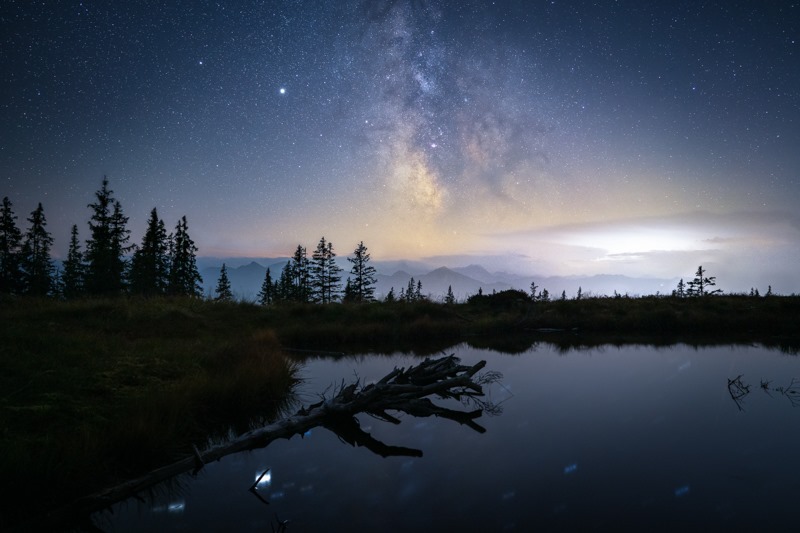
We arrived back at the trailhead and headed to Old Sheffield in search of a campsite. We ended up staying at one recommended by @Titans, it had great overlooks and great views of the stars. The only downside was that with the wind that started picking up the sand went everywhere.


I tried my hand at some star pictures, but I need to get out and practice, or do some research. They always looks so much better on the camera view screen then when I enlarge them not so much. Any tips would be appreciated.

March 9th
We woke up and tried to get as much sand as we could off of us as we ate breakfast and got ready for the big day. The sunrise from this site is amazing.

We drove down Old Sheffield a little ways and prepared to start our Bighorn Loop. I had been reading about the loop, researching it as much as possible, creating routes on gaia as well as on a couple different maps I had with me along with the compass.
The day started off great, a little breezy and a comfortable temperature for hiking in a light jacket. We arrived at the dryfall early in Bighorn and had no difficulty down climbing. My wife in there for scale is 5'5".

We continued down Bighorn enjoying the colors and the occasional slots. We could have stayed in the canyon except for one area that we had to bypass due to a large keeper pothole and a rappel that looked to be at least 15-20 feet. That was around midway through the Bighorn section. Here are a few pictures of the Bighorn section.


My wife found this above a short sections of slots I was playing around in. We put it right back where we found it.

After working our way through Bighorn down toward Harris Wash we had fallen behind schedule, so we skipped the short West Bighorn section of slots and began the trudge down Harris Wash towards Zebra.
Harris had some interesting scenery but the couple of miles to Zebra in the sand was exhausting. This was the least enjoyable portion of this loop and most likely the reason we would not repeat this hike as a loop.

We eventually arrived at Zebra. When we hiked to Zebra in 2019 there was water flowing out of the mouth of the canyon, this year it was bone dry. We hiked in and this slot is where it became noticeable that I put on some weight in 2020. I tried to stem up so I could get back to the more photogenic sections but I was beginning to get tired and kept slipping so the picture below was the best I was able to get.

We went up the slab to Zebra's left and started our route back toward Old Sheffield. I wish I had taken a photo of the potholes above Zebra to compare against 2019. There was so much water in 2019 that I had not realized how deep some of the pot holes were until I could see them dry this year. Instead of taking pictures we poured large quantities of sand from our shoes and began the trek back.
The area here stayed mostly above washes and canyons but still had a bit of sand in involved. It was beautiful but we had fallen further behind and my wife was starting to get worried with some dark clouds on the horizon.

We didn't take as many photos as I would have liked because we were trying to get back as quickly as possible. Here are a few from that section of the hike, including our UFO Moqui Marble.


We trudged along, getting more tired and noticing the occasional mountain lion scat.
My phone started to get pretty low on battery so I pulled out the battery pack and realized I didn't have the charging cable. We had been using Gaia to help navigate and this forgotten cable along with the dark clouds, wind, being behind schedule and being tired pushed my wife to having to restrain tears. I should note that my wife is used to fairly long hikes and these trips are for both of us. I never feel like I'm dragging her along, so to see her like that made me feel horrible. Luckily I did have the maps and compass and kept reassuring her that we would be fine. Thank you FFA orienteering competitions from 25 years ago.
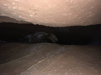
We eventually connected with the old road that was mentioned in Steve Allen's notes, although if you follow that guide there is no mesa with a prominent cave, there is a mesa with what appears to be a dark alcove.
Once we reached the old road and taking it to its end and reaching a high point where we could see our truck my wife visibly lightened. We found our way down some cliff bands and hiked back to Old Sheffield road and up to our truck. Overall we had ended up out there for about 7 hours and 40 minutes and had gone 14.5 miles. After a sufficient enough time to forget this hike my wife and I both agreed that we would like to explore the area between Old Sheffield and Zebra a bit more, but as a day hike out and back. Also the same with the West fork of Bighorn, just an out and back from the HITRR side.
We decided to skip cooking and had pizza at Escalante Outfitters, not sure if because we were so tired and hungry or what, but that was some of the best pizza we have ever eaten. We then ended up camping in the same spot again because we were exhausted and didn't want to look for a new one.
March 10th
Upon waking up our plans for this day changed. My wife had a few blisters and one of my big toe nails was completely black. The sand had gotten under the insole and forced by toe up towards the top of the shoe for much of the hike. It had ended up being much worse than I thought. We had planned to hike Upper Calf Creek Falls and head home through Boulder, but instead headed out the other direction and went to Bryce Canyon and checked out the overlooks. We had never been before and after our brief visit I think the family trip we had scheduled for GSENM might be changed to Bryce Canyon.
Here are a few pictures from Bryce


We stopped in Panguitch for lunch and then headed home. My wife is saying with how the Bighorn Loop went for us that she is saying the score is Escalante 2 Us 0. It might be a couple of years before I can convince her to explore GSENM more, luckily there is lots of other stuff hike.
Also I have no idea why those first few pictures are sideways. They show up with the correct orientation everywhere else. If I can figure out what is going on I will edit this later to make it a little easier on the eyes. Edit - Took at @Titans suggestions and was able to fix the sideway pictures.
March 8
This year we headed down in March again, but what a difference a couple of years can make. He headed down on March 8th at a chipper 5 a.m. We arrived at the Interagency Visitor Center at around 11 a.m. I knew that they weren't open but we picked up a camping permit and I had really hoped that at least the restrooms would be open since they were exterior to the main building, but no luck.
After filling up on gas and taking care of some other business we headed down HITRR. Instead of mud this time we were treated to dust. We drove to the Upper Dry Fork Trailhead and set off on a trip through the Dry Fork Narrows heading towards Peak-a-Boo and Spooky.
We had the Dry Fork Narrows completely to ourselves until right at the end and they approached Peak-a-Boo. There were a great warm up to exploring the area.
We arrived at the start of Peak-a-Boo to a bit of a line. A couple of people decided to turn back after attempting to climb in and a group behind us decided to leave after seeing the couple tap out. After waiting a few minutes it was finally our turn to scramble up into Peak-a-Boo.
Immediately upon entering we were greeted by a series of small bridges. I am sure most of you have probably done these canyons, but it was our first time and after reading about them so many times we were really soaking them in.
We worked our way through Peak-a-Boo trying to leave enough space between the groups in front of us so that everyone could somewhat feel like they had it to themselves. There were no groups immediately behind us, so taking our time wasn't holding anyone up.
We eventually popped out of Peak-A-Boo and headed across to spooky, talking with the groups that had exited ahead of us. When we arrived at Spooky they let us go first and we began our decent. My wife was comparing Spooky to a haunted house and was giggling the entire way through. We eventually arrived at the chockstone jungle area and there was a couple trying to talk a woman through it. We couldn't even see her and she had apparently went over the top rather than dropping down below, which was what the couple guiding her planned to do as well until I told them it was a lot easier to go under and offered them the use of a small rope I had if they needed it. They let us go first, partly because I'm not sure they trusted me. There was a knotted rope there that made the decent much easier, but if you stay on the left side it is a pretty easy down climb.
We enjoyed the rest of our time in Spooky and upon exiting contemplated heading towards Brimstone but we wanted to find a campsite on Old Sheffield before it got dark. On our way back to the Trailhead we found a woman and couple of kids that were kind of roaming around, and eventually one of the kids asked if we knew how to get back to the trailhead. Apparently they had been wandering around in circles for about 30 minutes not sure of what way to go.
We arrived back at the trailhead and headed to Old Sheffield in search of a campsite. We ended up staying at one recommended by @Titans, it had great overlooks and great views of the stars. The only downside was that with the wind that started picking up the sand went everywhere.
I tried my hand at some star pictures, but I need to get out and practice, or do some research. They always looks so much better on the camera view screen then when I enlarge them not so much. Any tips would be appreciated.
March 9th
We woke up and tried to get as much sand as we could off of us as we ate breakfast and got ready for the big day. The sunrise from this site is amazing.
We drove down Old Sheffield a little ways and prepared to start our Bighorn Loop. I had been reading about the loop, researching it as much as possible, creating routes on gaia as well as on a couple different maps I had with me along with the compass.
The day started off great, a little breezy and a comfortable temperature for hiking in a light jacket. We arrived at the dryfall early in Bighorn and had no difficulty down climbing. My wife in there for scale is 5'5".
We continued down Bighorn enjoying the colors and the occasional slots. We could have stayed in the canyon except for one area that we had to bypass due to a large keeper pothole and a rappel that looked to be at least 15-20 feet. That was around midway through the Bighorn section. Here are a few pictures of the Bighorn section.
My wife found this above a short sections of slots I was playing around in. We put it right back where we found it.
After working our way through Bighorn down toward Harris Wash we had fallen behind schedule, so we skipped the short West Bighorn section of slots and began the trudge down Harris Wash towards Zebra.
Harris had some interesting scenery but the couple of miles to Zebra in the sand was exhausting. This was the least enjoyable portion of this loop and most likely the reason we would not repeat this hike as a loop.
We eventually arrived at Zebra. When we hiked to Zebra in 2019 there was water flowing out of the mouth of the canyon, this year it was bone dry. We hiked in and this slot is where it became noticeable that I put on some weight in 2020. I tried to stem up so I could get back to the more photogenic sections but I was beginning to get tired and kept slipping so the picture below was the best I was able to get.
We went up the slab to Zebra's left and started our route back toward Old Sheffield. I wish I had taken a photo of the potholes above Zebra to compare against 2019. There was so much water in 2019 that I had not realized how deep some of the pot holes were until I could see them dry this year. Instead of taking pictures we poured large quantities of sand from our shoes and began the trek back.
The area here stayed mostly above washes and canyons but still had a bit of sand in involved. It was beautiful but we had fallen further behind and my wife was starting to get worried with some dark clouds on the horizon.
We didn't take as many photos as I would have liked because we were trying to get back as quickly as possible. Here are a few from that section of the hike, including our UFO Moqui Marble.
We trudged along, getting more tired and noticing the occasional mountain lion scat.
My phone started to get pretty low on battery so I pulled out the battery pack and realized I didn't have the charging cable. We had been using Gaia to help navigate and this forgotten cable along with the dark clouds, wind, being behind schedule and being tired pushed my wife to having to restrain tears. I should note that my wife is used to fairly long hikes and these trips are for both of us. I never feel like I'm dragging her along, so to see her like that made me feel horrible. Luckily I did have the maps and compass and kept reassuring her that we would be fine. Thank you FFA orienteering competitions from 25 years ago.
We eventually connected with the old road that was mentioned in Steve Allen's notes, although if you follow that guide there is no mesa with a prominent cave, there is a mesa with what appears to be a dark alcove.
Once we reached the old road and taking it to its end and reaching a high point where we could see our truck my wife visibly lightened. We found our way down some cliff bands and hiked back to Old Sheffield road and up to our truck. Overall we had ended up out there for about 7 hours and 40 minutes and had gone 14.5 miles. After a sufficient enough time to forget this hike my wife and I both agreed that we would like to explore the area between Old Sheffield and Zebra a bit more, but as a day hike out and back. Also the same with the West fork of Bighorn, just an out and back from the HITRR side.
We decided to skip cooking and had pizza at Escalante Outfitters, not sure if because we were so tired and hungry or what, but that was some of the best pizza we have ever eaten. We then ended up camping in the same spot again because we were exhausted and didn't want to look for a new one.
March 10th
Upon waking up our plans for this day changed. My wife had a few blisters and one of my big toe nails was completely black. The sand had gotten under the insole and forced by toe up towards the top of the shoe for much of the hike. It had ended up being much worse than I thought. We had planned to hike Upper Calf Creek Falls and head home through Boulder, but instead headed out the other direction and went to Bryce Canyon and checked out the overlooks. We had never been before and after our brief visit I think the family trip we had scheduled for GSENM might be changed to Bryce Canyon.
Here are a few pictures from Bryce
We stopped in Panguitch for lunch and then headed home. My wife is saying with how the Bighorn Loop went for us that she is saying the score is Escalante 2 Us 0. It might be a couple of years before I can convince her to explore GSENM more, luckily there is lots of other stuff hike.
Also I have no idea why those first few pictures are sideways. They show up with the correct orientation everywhere else. If I can figure out what is going on I will edit this later to make it a little easier on the eyes. Edit - Took at @Titans suggestions and was able to fix the sideway pictures.
Attachments
Last edited: