Grand Staircase Escalante 4 or 5 day backcountry trip

Bockus

New Member
Joined
Oct 22, 2024
Messages
1
Greetings from interior Alaska. I'm trying to put together a 4 or 5 day backcountry trip for Grand Staircase Escalante monument. We are both endurance athletes capable of covering big miles and are looking for a larger loop that we can do while leaving our rental car parked while we are out there. We are trying to get away from the crowds and will be there sometime in late March or early April. Any and all recommendations are much appreciated! Thank you all for your time and effort...
-Kyle
 
Greetings! We're hoping to do a guided backpack trip in Wrangell-St. Elias next summer, so I might ask for your advice on that...

There are many great options in GSENM, and there's lots of great info here on BCP which you may have already started reviewing. Have you ever hiked or backpacked in this region? It's necessary to know your water sources and plan accordingly. Also, in late March/early April river wading will be cold and deep in places, and river wading is part of any GSENM trip I'm aware of. Since you're from Alaska, that might not phase you but keep it in mind.

Our first trip to GSENM was outstanding - Boulder Mail Trail -> Escalante River @ Pine Creek -> along Escalante back to car @ Hwy 12 bridge. We arranged a shuttle to get us to the TH, but @TrailScot has a great report about connecting the route by foot so a shuttle isn't necessary. There are lots of great reports here about the BMT, and lots of people enjoy connecting BMT to Escalante River via Death Hollow. I hate cold water, so when we went in early April I knew that wouldn't work for us.

Our next trip was outstanding, too (well, they all are). We did the Little Death Hollow-Wolverine loop with a couple days basecamp at the Escalante River that enabled us to get to the Cosmic Ashtray (aka Volcano) and other fabulous stuff on the other side of the river. You might want to combine this with the Gulch and/or Harris Wash. I got lots of great info from @James and Amy, @John Morrow, and others here.

Our trip this spring was also outstanding, as we took the Coyote Gulch route and extended it multiple days. The scenery is fantastic. We were there later in April so the river was warmer than it will be earlier, and you're in the water a lot on this trip. I know some people do a longer trip in this area that includes Coyote Gulch as well as other canyons, but our canyoneering ability wasn't strong enough to consider that and we didn't have enough time anyway. Again, we got lots of great info from people here, including @Jammer and @desertvic and others.

I've seen @Bob's info about a trip we hope to do sometime soon, which is Silver Falls/Choprock/Neon Canyon/Golden Cathedral. I'm sure that's great, too!
 
That time of the year can be a roll of the dice! Three out of the six times we have been down there it has snowed and rained on us. There is no shortage of excellent info on this site. My number one warning is DO NOT drive on any non-paved road if they are wet or if rain is in the forecast....Those roads turn into dangerous and possibly deadly slippery mud.
 
Stevens/Fold loop exiting Fools Canyon. I prefer to start/end at the Coyote Gulch sneak route across from Jacob Hamblin Arch, but there are other options. Tack on Shofar, Hydra, Ichabod Canyons exiting the Bobway if you have time and capable of route finding on up to low 5th class terrain. You're unlikely to encounter anyone outside of the Coyote Gulch portion.
 
Stevens/Fold loop exiting Fools Canyon. I prefer to start/end at the Coyote Gulch sneak route across from Jacob Hamblin Arch, but there are other options. Tack on Shofar, Hydra, Ichabod Canyons exiting the Bobway if you have time and capable of route finding on up to low 5th class terrain. You're unlikely to encounter anyone outside of the Coyote Gulch portion.
That’s the longer loop I was thinking of!
 
The GSENM is a world class place to explore and backpack in. My wife and I have made numerous trips to region and have enjoyed every one of them. But, a small word of caution. You write that you are "endurance athletes capable of covering big miles". Essentially all travel in the monument is cross-country and not on any form of trail. We are both deeply experienced and reasonably strong backpackers and we often covered less than ten miles per day on our southern Utah trips. Obstacles, both large and small, both passable and impassible are plentiful. Route finding can be difficult and unpredictable. The dry slot canyon you are following may suddenly present a mile-long section full of cold water. The Escalante River can go from easily wade-able to flash flood impassible in an amazingly short period of time. Getting from a canyon floor to a rim may be stymied by as little as a ten foot high vertical slickrock wall and you will have to backtrack and find other possibilites. Depending on on the recent past weather, water in many locations can be hard to find with sources few and far apart: expect to carry a lot of it. Unless you have a lot direct experience traversing slickrock country, don't assume a lot of big days mileage wise. Besides, you will find yourself constantly slowed down by the stunning beauty of the place, with unexpected surprises everywhere that require time to explore and understand.

And all of the above is what helps make the place so magical. I hope that you have a fabulous trip.

James (and Amy)
 
Last edited:
So 50-60 miles?

Order Steve Allens Escalante book, get familiar with Caltopo. Use the two together and prepare to spend time. Once you get something assembled that seems within your limits take it here with more direct questions

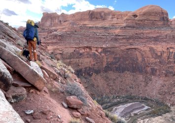
I think this is between Hydra and Ichabod. We might have been on the wrong bench here. Typical mile/hour terrain

IMG_4214.JPG
 
Last edited:
So 50-60 miles?

Order Steve Allens Escalante book, get familiar with Caltopo. Use the two together and prepare to spend time. Once you get something assembled that seems within your limits take it here with more direct questions

I think this is between Hydra and Ichabod. We might have been on the wrong bench here. Typical mile/hour terrain

View attachment 136545
Great picture!
 
Back
Top