Ben
Member
- Joined
- Sep 12, 2014
- Messages
- 1,873
If you haven't seen the report of my other Grand Canyon trip, in 2011 i went to the North Rim with my family, but just long enough to see that the canyon was there. Two years later i managed to make it down to backpack with my brother. If you only see the Grand Canyon from the rim, you haven't really seen it. We hiked down the North Kaibab trail, up the Bright Angel, hiked Horseshoe Mesa during an extra day on the South Rim, and then hiked back across the South and North Kaibab trails.
October 2013 the federal government shut down because people are idiots. This almost prevented this trip. But then state governments managed to fund some of the national parks and reopen them. I believe they reopened on a friday, i drove down to Provo to meet up with my brother on saturday. This ended up working out to our benefit. There were not near so many people in the canyon, at least initially, as there normally are.
We camped the first night on the North Rim. Spencer had never been to the Grand Canyon before. We about froze up there. I think it was below 20*. We weren't exactly prepared for that, but we also survived. Here's Spencer checking it out for the first time.
An other shot of Spencer. Looking south.
Sun going down across The Transept from the North Rim camp ground.
At the back country office the next morning. Pretty stoked on a thirty pound pack for a week.
The first day we had fourteen miles to hike down the North Kaibab trail to Bright Angel camp ground. Here's the top of the Coconino, a totally different place from lower in the canyon.
The Supai tunnel.

Cactus, so we know we're in Arizona.
Looking down Roaring Springs canyon in the Supai.

A bridge.
This was our friend on the way down. She was on vacation from the National Science Institute. She had hiked all the way across from the south side the day before, but was going back over two days. Here's the trail blasted out of the cliff.
You can see the trail winding it's way below the Redwall here.
Looking across. I believe Roaring Springs is at the brighter green patch at the lower right..jpg")
Cactus garden at the pump house at Roaring Springs.
Looking back up from below Roaring Springs canyon. In Bright Angel now.

We got in to Bright Angel camp ground late, hiking by moon light. It was actually really nice. The next morning we hiked the river walk before packing up camp and going up to Indian Garden. We came across this ram near the silver bridge, probably only because there hadn't been people camping at Bright Angel for a couple weeks. I have a hard time imagining sheep coming around here normally.
Naturally, it ran off.
Looking back across the bridge as the sun came up.
Looking up the river.
As we were making our way from the silver bridge to the black bridge to go back to the camp ground for breakfast we heard some thing coming toward us along the trail. We saw an other sheep, just trotting along our way. It came around a corner, and when it saw us there was probably one of the funniest things i have ever seen backpacking. It pulled a 180 so fast there was actually gravel skittering. It was like some thing out of a cartoon. Like it had actually spun out, booking it back the opposite direction. I have never seen an animal so surprised to see me. Seems it had not expected humans along the trail that day. It's the white spot below center.
Looking down on the black bridge from the river trail.
The tunnel to the bridge. A year later i had some guys from Israel tell me they thought this looked like the entrance to Moria.

Looking back along the bridge.
The unearthed ruins on the Bright Angel delta.
The silver bridge in some better light. I like this picture.
The river from the bridge, on our way to Indian Garden now. Less than five miles today. We wanted to take the time to enjoy it.
Spencer.

You can actually see the silver and the black bridge in this picture.
Yucca.

Looking up the river. The silver bridge is still in the picture.
No more bridge.
Near Pipe Creek.

The beach at Pipe Creek, before we head up.
Me and Spencer.

Looking back across on the way up. Ah, Supergroup.
Cottonwood in the Tapeats, not far below Indian Garden.

Very near Indian Garden.

We got to Indian Garden so early in the after noon. I hiked out the Tonto trail all the way around Horn Creek. Huge views there.


Check that cloud.
The sun was going down, or i would've just kept on hiking. Spencer stayed at Indian Garden, his knee was bothering him.
The next morning i hiked out to Panorama Point from Indian Garden before we hiked up to the rim. That was going to be less than five miles again. Passing the junction.
On the way out.
That's the point there with the railing. Don't fall off.
And the river from the point.


Looking at the south rim from the point. Indian Garden all the way on the left.

On the way back. Indian Garden center. Any thing look out of place.
On the Bright Angel trail. Easy hike up.
From one of the rest houses. Indian Garden is the green trees, you can see the trail.

Up on the rim. Check the crowds. Bright Angel canyon across the river. The North Kaibab trail comes down there.

Getting dark on the rim. Nearly all these pictures were taken with an ipod.
A view from the south rim. We spent two nights at Mather camp ground and hiked Horseshoe Mesa on our day in between.
.jpg")
Horseshoe Mesa. Great view over the east.
The old trail construction on the Grandview trail.


Spencer accidentally wandered into the radiation zone.
The old cabin. A Spencer in the window.
Looking back up at Grandview Point over Cottonwood Canyon. We just spent the after noon down here. It was fantastic, perfect weather. A raven stole a package of pepperoni from my pack while it was left at a trail as we wandered around. It opened up the zipper and every thing.
Looking across at Vishnu Temple.

Cactus.
This one had spines for days.

Spencer, view to the east. From the west tip of Horseshoe Mesa. Supergroup, and Palisades of the Desert.

What a lovely juniper. And the shade.
More lovely cactus.


And yucca.
On the way back up. Check those logs.
We took advantage of the opportunity to eat at the cafeteria.
This is how we got around on the South Rim. A lot of americans drove right past us. A lot. And then a few friends from Mexico gave us a ride out to the trail head. One of them sat on an other's lap to make room for us. Sweet people. On the way back a lot of americans drove past us again, and then we got a ride from a nice young swiss couple. Americans are lame. The foreigners were super cool.
At Mather camp ground, these notices were still around.
The next day we hiked down the South Kaibab to Bright Angel again. Switchbacks!
View from the South Kaibab.
This is a really good picture of the layers. Kaibab, Toroweap, Coconino, Hermit, Supai, Redwall, Muav.

Mules.

Coming down.
Here you can see the out houses at the Tipoff.
Supergroup, river, river trail, silver bridge. From the South Kaibab.

And then on the beach at Bright Angel. Black bridge in the back ground.

Pissing in the river.
Bright Angel camp ground.
So we hiked up the Clear Creek trail that evening to the over look.
Tarantula at the camp.
Camp.
The next day we had to hike up to Cottonwood camp. We went to Ribbon Falls along the way. Crossing Bright Angel Creek to get to the falls.

This is one of the tallest agave stalks i ever saw.

The base of the travertine mound below Ribbon Falls.
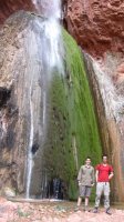
The mound in entirety. Plus Spencer.

Behind the falls.


Hanging our shirts out to dry at Cottonwood. In october.

The last day we hiked the rest of the the way out to the rim. Here's a picture of Roaring Springs.

Near the rim.
And we're back to the parking lot.
Featured image for home page:

October 2013 the federal government shut down because people are idiots. This almost prevented this trip. But then state governments managed to fund some of the national parks and reopen them. I believe they reopened on a friday, i drove down to Provo to meet up with my brother on saturday. This ended up working out to our benefit. There were not near so many people in the canyon, at least initially, as there normally are.
We camped the first night on the North Rim. Spencer had never been to the Grand Canyon before. We about froze up there. I think it was below 20*. We weren't exactly prepared for that, but we also survived. Here's Spencer checking it out for the first time.
An other shot of Spencer. Looking south.
Sun going down across The Transept from the North Rim camp ground.
At the back country office the next morning. Pretty stoked on a thirty pound pack for a week.
The first day we had fourteen miles to hike down the North Kaibab trail to Bright Angel camp ground. Here's the top of the Coconino, a totally different place from lower in the canyon.
The Supai tunnel.
Cactus, so we know we're in Arizona.
Looking down Roaring Springs canyon in the Supai.
A bridge.
This was our friend on the way down. She was on vacation from the National Science Institute. She had hiked all the way across from the south side the day before, but was going back over two days. Here's the trail blasted out of the cliff.
You can see the trail winding it's way below the Redwall here.
Looking across. I believe Roaring Springs is at the brighter green patch at the lower right.
Cactus garden at the pump house at Roaring Springs.
Looking back up from below Roaring Springs canyon. In Bright Angel now.
We got in to Bright Angel camp ground late, hiking by moon light. It was actually really nice. The next morning we hiked the river walk before packing up camp and going up to Indian Garden. We came across this ram near the silver bridge, probably only because there hadn't been people camping at Bright Angel for a couple weeks. I have a hard time imagining sheep coming around here normally.
Naturally, it ran off.
Looking back across the bridge as the sun came up.
Looking up the river.
As we were making our way from the silver bridge to the black bridge to go back to the camp ground for breakfast we heard some thing coming toward us along the trail. We saw an other sheep, just trotting along our way. It came around a corner, and when it saw us there was probably one of the funniest things i have ever seen backpacking. It pulled a 180 so fast there was actually gravel skittering. It was like some thing out of a cartoon. Like it had actually spun out, booking it back the opposite direction. I have never seen an animal so surprised to see me. Seems it had not expected humans along the trail that day. It's the white spot below center.
Looking down on the black bridge from the river trail.
The tunnel to the bridge. A year later i had some guys from Israel tell me they thought this looked like the entrance to Moria.
Looking back along the bridge.
The unearthed ruins on the Bright Angel delta.
The silver bridge in some better light. I like this picture.
The river from the bridge, on our way to Indian Garden now. Less than five miles today. We wanted to take the time to enjoy it.
Spencer.
You can actually see the silver and the black bridge in this picture.
Yucca.
Looking up the river. The silver bridge is still in the picture.
No more bridge.
Near Pipe Creek.
The beach at Pipe Creek, before we head up.
Me and Spencer.
Looking back across on the way up. Ah, Supergroup.
Cottonwood in the Tapeats, not far below Indian Garden.
Very near Indian Garden.
We got to Indian Garden so early in the after noon. I hiked out the Tonto trail all the way around Horn Creek. Huge views there.
Check that cloud.
The sun was going down, or i would've just kept on hiking. Spencer stayed at Indian Garden, his knee was bothering him.
The next morning i hiked out to Panorama Point from Indian Garden before we hiked up to the rim. That was going to be less than five miles again. Passing the junction.
On the way out.
That's the point there with the railing. Don't fall off.
And the river from the point.
Looking at the south rim from the point. Indian Garden all the way on the left.
On the way back. Indian Garden center. Any thing look out of place.
On the Bright Angel trail. Easy hike up.
From one of the rest houses. Indian Garden is the green trees, you can see the trail.
Up on the rim. Check the crowds. Bright Angel canyon across the river. The North Kaibab trail comes down there.
Getting dark on the rim. Nearly all these pictures were taken with an ipod.
A view from the south rim. We spent two nights at Mather camp ground and hiked Horseshoe Mesa on our day in between.
Horseshoe Mesa. Great view over the east.
The old trail construction on the Grandview trail.
Spencer accidentally wandered into the radiation zone.
The old cabin. A Spencer in the window.
Looking back up at Grandview Point over Cottonwood Canyon. We just spent the after noon down here. It was fantastic, perfect weather. A raven stole a package of pepperoni from my pack while it was left at a trail as we wandered around. It opened up the zipper and every thing.
Looking across at Vishnu Temple.
Cactus.
This one had spines for days.
Spencer, view to the east. From the west tip of Horseshoe Mesa. Supergroup, and Palisades of the Desert.
What a lovely juniper. And the shade.
More lovely cactus.
And yucca.
On the way back up. Check those logs.
We took advantage of the opportunity to eat at the cafeteria.
This is how we got around on the South Rim. A lot of americans drove right past us. A lot. And then a few friends from Mexico gave us a ride out to the trail head. One of them sat on an other's lap to make room for us. Sweet people. On the way back a lot of americans drove past us again, and then we got a ride from a nice young swiss couple. Americans are lame. The foreigners were super cool.
At Mather camp ground, these notices were still around.
The next day we hiked down the South Kaibab to Bright Angel again. Switchbacks!
View from the South Kaibab.
This is a really good picture of the layers. Kaibab, Toroweap, Coconino, Hermit, Supai, Redwall, Muav.
Mules.
Coming down.
Here you can see the out houses at the Tipoff.
Supergroup, river, river trail, silver bridge. From the South Kaibab.
And then on the beach at Bright Angel. Black bridge in the back ground.
Pissing in the river.
Bright Angel camp ground.
So we hiked up the Clear Creek trail that evening to the over look.
Tarantula at the camp.
Camp.
The next day we had to hike up to Cottonwood camp. We went to Ribbon Falls along the way. Crossing Bright Angel Creek to get to the falls.
This is one of the tallest agave stalks i ever saw.
The base of the travertine mound below Ribbon Falls.
The mound in entirety. Plus Spencer.
Behind the falls.
Hanging our shirts out to dry at Cottonwood. In october.
The last day we hiked the rest of the the way out to the rim. Here's a picture of Roaring Springs.
Near the rim.
And we're back to the parking lot.
Featured image for home page:
Last edited: